|
Sihlsee
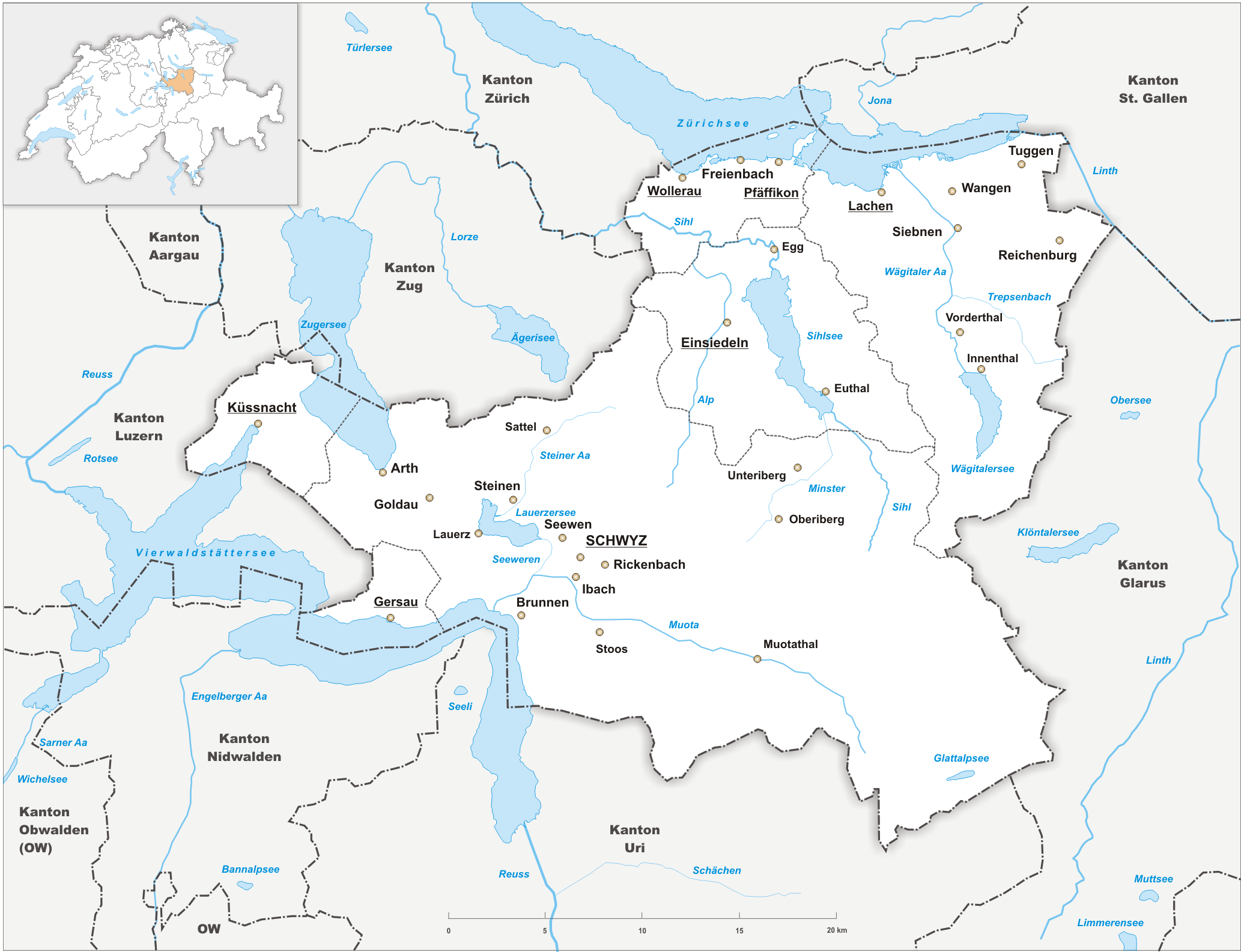
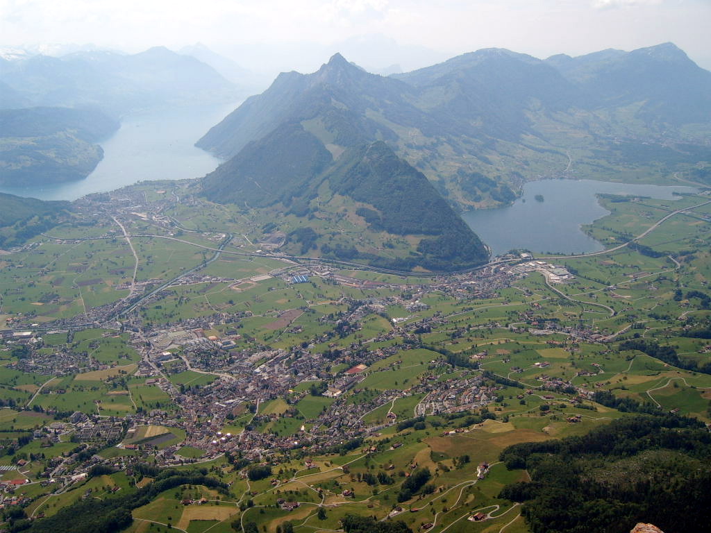
__NOTOC__ The Sihlsee (in English sometimes called ''Lake Sihl'') is an artificial lake in the Swiss canton of Schwyz, near the town of Einsiedeln. The lake was created by damming the river Sihl and flooding a section of the upper Sihl Valley. The lake feeds the , which is located to the north-east in Altendorf on the upper section of Lake Zürich (the ''Obersee'') and which supplies electricity to the Swiss Federal Railways (SBB). Its concrete dam is high and m long. The lake is the largest artificial lake of Switzerland in terms of surface with a maximum length of and maximum width of . The maximum depth is , and the lake has an approximate volume of . The power plant project started in 1932. A concrete dam and two viaducts over the lake were built before 1937 when the valley was flooded. As a result 107 farms disappeared completely and 1762 persons had to leave their homes. A failure of the dam could lead, according to studies, to an high flood wave through the lower Sih ... [...More Info...] [...Related Items...] OR: [Wikipedia] [Google] [Baidu] |
Sihl
The Sihl is a Switzerland, Swiss river that rises near the Druesberg mountain in the canton of Schwyz, and eventually flows into the Limmat in the centre of the Zürich, city of Zürich, after crossing the Zürich–Winterthur railway at . It has a length of , including the Sihlsee reservoir, through which the river flows. Water is abstracted from the river at the Sihlsee, leading to decreased downstream water flows and a consequent reduction in water quality. The river flows through, or along the border of, the cantons of Canton of Schwyz, Schwyz, Canton of Zürich, Zürich and Canton of Zug, Zug. The main settlements of the Sihl Valley are all in the canton of Zürich, and include the towns of Langnau am Albis and Adliswil, along with a south-western segment of the city of Zürich. Above Langnau am Albis, some from the confluence with the Limmat, there are no major settlements alongside the river, and only a few small villages. Whilst the Einsiedeln, Switzerland, town of Einsied ... [...More Info...] [...Related Items...] OR: [Wikipedia] [Google] [Baidu] |
Sihl Valley
Sihl Valley ( German: ''Sihltal'') is a river valley and belongs to the Zimmerberg-Sihltal region located in the Horgen (district), district of Horgen in the canton of Zurich, Switzerland. Commonly ''Sihltal'' is used as the name of the Lower Sihl Valley, i.e. the area in the southwest of the city of Zürich. Geography In common The area alongside Lake Zürich had been formed as the left moraine of the Last Glacial Period, Ice Age glacier, the bed of which is now the Lake Zürich and the valley of the Sihl. Sihl valley is extensively wooded, but also cultivated and heavily populated in its lower parts. The Sihl () is the name of a long river located in the cantons of Canton of Schwyz, Schwyz (SZ) and Canton of Zurich, Zürich (ZH). The valley compromises parts of the Districts of Switzerland, districts of Einsiedeln (district), Einsiedeln (SZ) (upper Sihl valley), Horgen (district), Horgen (ZH) and Zürich (district), Zürich. The region of the valley comprises about . ... [...More Info...] [...Related Items...] OR: [Wikipedia] [Google] [Baidu] |
Einsiedeln, Switzerland
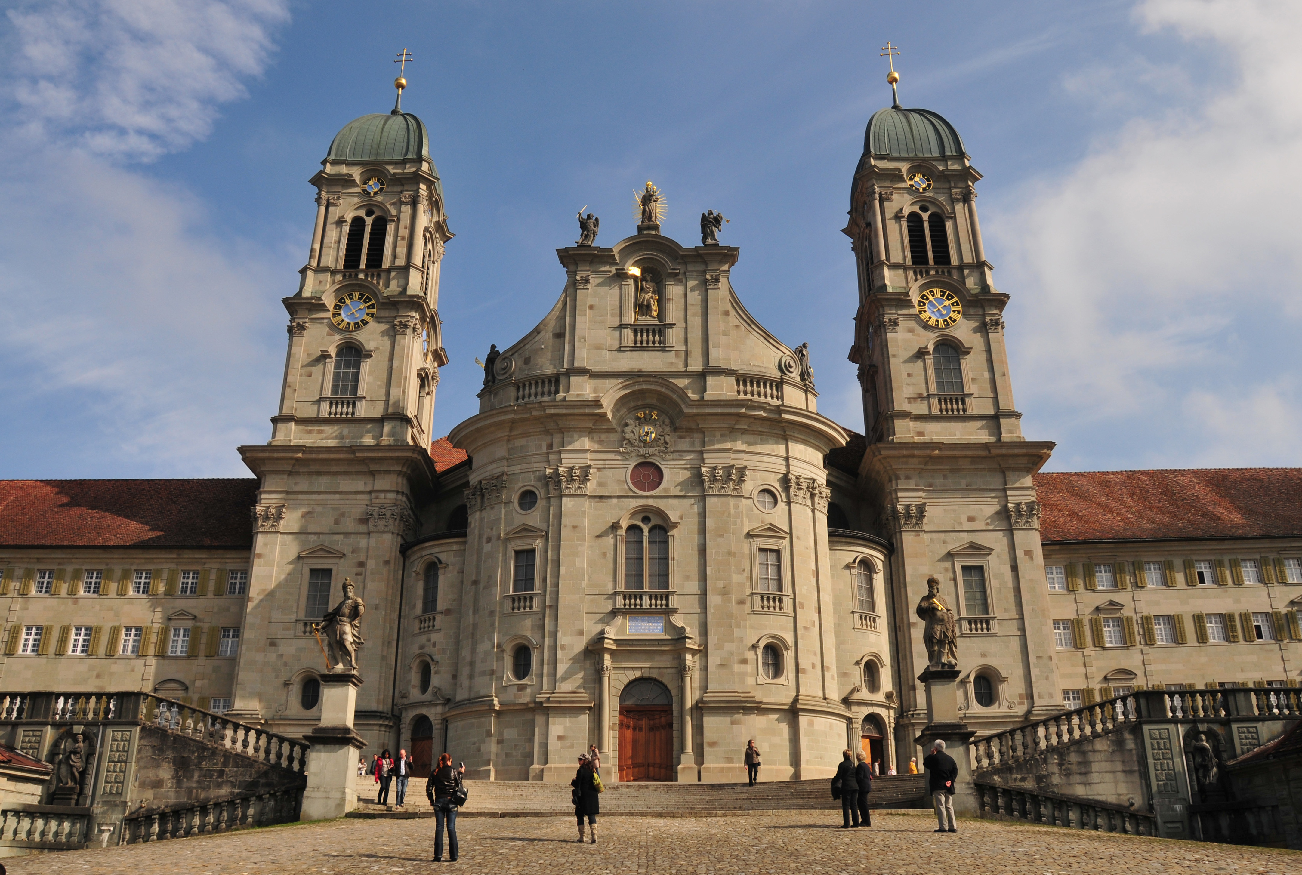
Einsiedeln () is a municipality and district in the canton of Schwyz in Switzerland known for its monastery, the Benedictine Einsiedeln Abbey, established in the 10th century. History Early history There was no permanent settlement in the area prior to the early medieval period, but numerous artefacts left by prehistoric hunters, dated to the Mesolithic to Bronze Age were recovered. The original " hermitage" is associated with St. Meinrad, a Benedictine monk from the family of the Counts of Hohenzollern. According to legend, Meinrad lived on the slopes of Mt. Etzel from 835 until his death in 861. During the next eighty years Saint Meinrad's hermitage was never without one or more hermits emulating his example. One of the hermits, named Eberhard, previously Provost of Strasburg, erected a monastery and church there, of which he became first abbot. Work on the monastery is said to have begun in 934. [...More Info...] [...Related Items...] OR: [Wikipedia] [Google] [Baidu] |
Minster (river)
The Minster is a river in the Swiss canton of Schwyz and a tributary of the Sihl river. It has a length of . Since the creation of the artificial Sihlsee reservoir by impounding the Sihl, the Minster now flows into the reservoir rather than directly into the river. The river's headwaters lie near the Ibergeregg pass, on the slopes of the Furggelenstock and Firstspitz mountains. From there it flows in a north-western direction to the villages of Oberiberg and Unteriberg. Between the two villages, the river flows under the Jessenenbruecke bridge. Some below this bridge, the Minster receives the waters of the Waag river, whilst a further on, it flows into the southern end of the Sihlsee. See also * List of rivers of Switzerland The following is a list of rivers of Switzerland (and tributaries thereof). Included rivers flow either entirely or partly through Switzerland or along its international borders. Swiss rivers belong to five drainage basins, i.e. of the Rhine, t ... [...More Info...] [...Related Items...] OR: [Wikipedia] [Google] [Baidu] |
Canton Of Schwyz
The canton of Schwyz ( ; ; ; ) is a Cantons of Switzerland, canton in central Switzerland between the Swiss Alps, Alps in the south, Lake Lucerne to the west and Lake Zürich in the north, centred on and named after the town of Schwyz. It is one of the founding cantons of Switzerland; Switzerland's name is derived from the name of the canton, and the flag of Switzerland from its coat of arms. For the history of the name, see Schwyz. The Swiss Federal Charter is on display in Schwyz. Northeast of the town of Schwyz is Einsiedeln Abbey. History Prehistory to the Roman era The earliest traces of humans in Schwyz are from the Upper Paleolithic and Early Mesolithic, or about 12,500 BC. An excavation of the karst caves in the valley of the Muota river (''Muotatal'') revealed numerous sites, some dating to the Younger Dryas period (). The alpine meadows at Bödmeren, Twärenen and Silberen were Stone Age hunter-gatherer camps. Ibex and red deer bones, along with charcoal, indicate tha ... [...More Info...] [...Related Items...] OR: [Wikipedia] [Google] [Baidu] |
Fluebrig
The Fluebrig (2,098 m) is a mountain massif of the Schwyzer Alps, located east of Unteriberg in the canton of Schwyz Schwyz (; ; ) is a town and the capital of the canton of Schwyz in Switzerland. The Federal Charter of 1291 or ''Bundesbrief'', the charter that eventually led to the foundation of Switzerland, can be seen at the ''Bundesbriefmuseum''. The of .... It is composed of several summits of which the highest is named ''Diethelm'' and the second highest ''Turner'' (2,069 m). On its northern side, the Fluebrig overlooks the Lake of Sihl (west) and the Lake of Wägital (east). References External links Fluebrig on Hikr Mountains of Switzerland Mountains of the Alps Mountains of the canton of Schwyz {{Schwyz-geo-stub ... [...More Info...] [...Related Items...] OR: [Wikipedia] [Google] [Baidu] |
Altendorf, Schwyz
Altendorf is a municipality in March District in the canton of Schwyz in Switzerland. History Altendorf is first mentioned in 972 as ''Rahprehteswilare''. In 1932, construction started on the '' Etzelwerk'', a hydro-electric power station to generate power for the Swiss Federal Railways. By 1937, the power station was complete and in operation. The plant continues in use today, and takes its water supply from the Sihlsee reservoir that lies to the south-west. Geography Altendorf has an area, , of . Of this area, 52.6% is used for agricultural purposes, while 37.5% is forested. Of the rest of the land, 9.4% is settled (buildings or roads) and the remainder (0.4%) is non-productive (rivers, glaciers or mountains). The municipality is located on the ''Obersee'' section of Lake Zurich. It is along the rail line Pfäffikon- Lachen and on the A3 motorway. It consists of the village of Altendorf and the hamlets of Seestatt along the lake and the hamlets of Muschelberg, Mittl ... [...More Info...] [...Related Items...] OR: [Wikipedia] [Google] [Baidu] |
Canton Of Schwyz
The canton of Schwyz ( ; ; ; ) is a Cantons of Switzerland, canton in central Switzerland between the Swiss Alps, Alps in the south, Lake Lucerne to the west and Lake Zürich in the north, centred on and named after the town of Schwyz. It is one of the founding cantons of Switzerland; Switzerland's name is derived from the name of the canton, and the flag of Switzerland from its coat of arms. For the history of the name, see Schwyz. The Swiss Federal Charter is on display in Schwyz. Northeast of the town of Schwyz is Einsiedeln Abbey. History Prehistory to the Roman era The earliest traces of humans in Schwyz are from the Upper Paleolithic and Early Mesolithic, or about 12,500 BC. An excavation of the karst caves in the valley of the Muota river (''Muotatal'') revealed numerous sites, some dating to the Younger Dryas period (). The alpine meadows at Bödmeren, Twärenen and Silberen were Stone Age hunter-gatherer camps. Ibex and red deer bones, along with charcoal, indicate tha ... [...More Info...] [...Related Items...] OR: [Wikipedia] [Google] [Baidu] |
Switzerland
Switzerland, officially the Swiss Confederation, is a landlocked country located in west-central Europe. It is bordered by Italy to the south, France to the west, Germany to the north, and Austria and Liechtenstein to the east. Switzerland is geographically divided among the Swiss Plateau, the Swiss Alps, Alps and the Jura Mountains, Jura; the Alps occupy the greater part of the territory, whereas most of the country's Demographics of Switzerland, 9 million people are concentrated on the plateau, which hosts List of cities in Switzerland, its largest cities and economic centres, including Zurich, Geneva, and Lausanne. Switzerland is a federal republic composed of Cantons of Switzerland, 26 cantons, with federal authorities based in Bern. It has four main linguistic and cultural regions: German, French, Italian and Romansh language, Romansh. Although most Swiss are German-speaking, national identity is fairly cohesive, being rooted in a common historical background, shared ... [...More Info...] [...Related Items...] OR: [Wikipedia] [Google] [Baidu] |
Reservoir
A reservoir (; ) is an enlarged lake behind a dam, usually built to water storage, store fresh water, often doubling for hydroelectric power generation. Reservoirs are created by controlling a watercourse that drains an existing body of water, interrupting a watercourse to form an Bay, embayment within it, excavating, or building any number of retaining walls or levees to enclose any area to store water. Types Dammed valleys Dammed reservoirs are artificial lakes created and controlled by a dam constructed across a valley and rely on the natural topography to provide most of the basin of the reservoir. These reservoirs can either be ''on-stream reservoirs'', which are located on the original streambed of the downstream river and are filled by stream, creeks, rivers or rainwater that surface runoff, runs off the surrounding forested catchments, or ''off-stream reservoirs'', which receive water diversion, diverted water from a nearby stream or aqueduct (water supply), aq ... [...More Info...] [...Related Items...] OR: [Wikipedia] [Google] [Baidu] |
Lake Zürich
Lake Zurich (, ; ) is a lake in Switzerland, extending southeast of the city of Zurich. Depending on the context, Lake Zurich or can be used to describe the lake as a whole, or just that part of the lake downstream of the Hurden peninsula and Seedamm causeway (between Pfäffikon, Schwyz, Pfäffikon and Rapperswil). In the latter case, the upstream part of the lake is called ''Obersee (Lake Zurich), Obersee'' (), while the lower part is sometimes also referred to as the Lower Lake (), respectively. Geography Lake Zurich is a glacial lake that was formed by the . Its main tributary is the River Linth, which rises in the glaciers of the Glarus Alps. The Linth originally flew directly into Lake Zurich, but was later diverted by the Hans Conrad Escher von der Linth, Escher canal (completed in 1811) into Lake Walen () from where its waters are now carried to the east end of Lake Zurich (near Schmerikon) by means of the straightened Linth canal (completed in 1816). Until the early ... [...More Info...] [...Related Items...] OR: [Wikipedia] [Google] [Baidu] |
Swiss Federal Railways
Swiss Federal Railways (, SBB; , CFF; , FFS) is the national railway company of Switzerland. The company was founded in 1902 and is headquartered in Bern. It used to be a State-owned enterprise, government institution, but since 1999 it has been a special stock corporation whose shares are held by the Swiss Confederation and the Cantons of Switzerland, Swiss cantons. It is the largest rail and transport company of Switzerland; it operates on most standard gauge lines of the Rail transport in Switzerland, Swiss railway network. It also heavily collaborates with most other transport companies of the country, such as the BLS AG, BLS, one of its main competitors, or (SOB), to provide fully integrated public transport timetable, timetables with Clock-face scheduling, cyclic schedules. SBB was ranked first among national Rail transport in Europe, European rail systems in the 2017 European Railway Performance Index for its intensity of use, quality of service, and safety rating. Whil ... [...More Info...] [...Related Items...] OR: [Wikipedia] [Google] [Baidu] |


