|
Shuqba
Shuqba () is a Palestinian town in the Ramallah and al-Bireh Governorate, located 17 kilometers northwest of the city of Ramallah in Palestinian National Authority, Palestine. Shuqba has a total area of , and the built-up area comprises . Shuqba was home to 5,459 inhabitants in 2017. Location Shuqba is located 17,9 km northwest of Ramallah. It bordered by Deir abu Mash'al and Al-Ittihad, Ramallah, Al-Itihad to the east, and Ni'lin, Qibya and Shabtin to the south. To the west is the Green Line (Israel), Green line, and to the north is 'Abud, Rantis, and Israeli settlement of Beit Aryeh-Ofarim, Ofarim. increasing in the 1931 census of Palestine, 1931 census to 696, still all Muslims, in a total of 130 houses.Mills, 1932, p23 In the Village Statistics, 1945, 1945 statistics, the population was 840, all Muslims,Government of Palestine, Department of Statistics, 1945, p 30/ref> while the total land area was 15,013 dunams, according to an official land and population survey. ... [...More Info...] [...Related Items...] OR: [Wikipedia] [Google] [Baidu] |
Natufian Culture
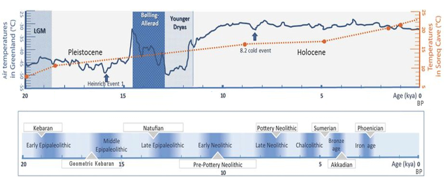
The Natufian culture ( ) is an archaeological culture of the late Epipalaeolithic Near East in West Asia from 15–11,500 Before Present. The culture was unusual in that it supported a sedentism, sedentary or semi-sedentary population even before the Origins of agriculture in West Asia, introduction of agriculture. Natufian communities may be the ancestors of the builders of the region's first List of Neolithic settlements, Neolithic settlements, which may have been the earliest in the world. Some evidence suggests deliberate cultivation of cereals, specifically rye, by the Natufian culture at Tell Abu Hureyra, the site of the earliest evidence of agriculture in the world. The world's oldest known evidence of the production of bread-like foodstuff has been found at Shubayqa 1, a 14,400-year-old site in Jordan, Jordan's northeastern desert, 4,000 years before the Origins of agriculture in West Asia, emergence of agriculture in Southwest Asia. In addition, the oldest known evidence ... [...More Info...] [...Related Items...] OR: [Wikipedia] [Google] [Baidu] |
Wadi An-Natuf
Wadi Natuf (Arabic: وادي الناطوف, ''Wadi al-Natuf'' / ''Wadi en-Natuf'') or Nahal Natuf () is a wadi (seasonal stream) in the West Bank and Israel, rising in the north of the Ramallah and al-Bireh Governorate of Palestine, crossing into Israel north of Modi'in and discharging into the Ayalon River at the Ben Gurion Airport. The Natufian culture–an archaeological culture of the Epipaleolithic period in the Levant region–is named after the wadi. Along with the Shuqba Cave, which opens onto its northern bank, Wadi Natuf has been nominated as a tentative UNESCO World Heritage Site in the State of Palestine Palestine, officially the State of Palestine, is a country in West Asia. Recognized by International recognition of Palestine, 147 of the UN's 193 member states, it encompasses the Israeli-occupied West Bank, including East Jerusalem, and th .... References Geography of Palestine Wadis of Israel Wadis of the West Bank {{Palestine-geo-stub ... [...More Info...] [...Related Items...] OR: [Wikipedia] [Google] [Baidu] |
Dorothy Garrod
Dorothy Annie Elizabeth Garrod, CBE, FBA (5 May 1892 – 18 December 1968) was an English archaeologist who specialised in the Palaeolithic period. She held the position of Disney Professor of Archaeology at the University of Cambridge from 1939 to 1952, and was the first woman to hold a chair at either Oxford or Cambridge. Early life and education Garrod was the daughter of the physician Sir Archibald Garrod and Laura Elizabeth Smith, daughter of the surgeon Sir Thomas Smith, 1st Baronet. She was born in Chandos Street, London, and was educated at home. Her first teacher was Isabel Fry as governess. Garrod recalled Fry teaching her, at age nine, in Harley Street with the daughter of Walter Jessop. She later attended Birklands School in St Albans. Pamela Jane Smith writes of Garrod as follows: "Garrod was a solid member of Britain's intellectual aristocracy. Her father, Sir Archibald Garrod, had been Regius Professor of Medicine at Oxford and is regarded as the founder of ... [...More Info...] [...Related Items...] OR: [Wikipedia] [Google] [Baidu] |
Shabtin
Shabtin is a Palestinian village in the Ramallah and al-Bireh Governorate of the State of Palestine, in the central West Bank. Shabtin is located north-west of Ramallah. Shabtin is bordered by Al Itihad to the east, Shuqba to the north, Ni'lin to the west, and Deir Qaddis to the south. Etymology The name Šabtīn /Šibtīn/ is Aramaic, and means ““sticks, canes”. History Just southeast of the village (at grid no. 1544/1528) is ''Kh. Shabtin'', where pottery sherds from the Persian,Finkelstein et al, 1997, p. 194 Persian/Hellenistic, late Roman,Dauphin, 1998, p. 830 Byzantine Umayyad/Abbasid eras have been found. The SWP noted "Traces of ruins" here. Pottery sherds from the Roman/Byzantine eras have been found at Shabtin.Finkelstein et al, 1997, p. 195 During the Crusader era, the area was a Crusader stronghold, centred around Aboud. Remains of a house from Crusader era have been identified in the centre of Shabtin. Sherds from the Mamluk era have been found in Shab ... [...More Info...] [...Related Items...] OR: [Wikipedia] [Google] [Baidu] |
Qibya
Qibya () is a Palestinian village in the West Bank, located northwest of Ramallah and exactly north of the large Israeli city of Modi'in. It is part of the Ramallah and al-Bireh Governorate, and according to the Palestinian Central Bureau of Statistics, it had a population of approximately 6,090 in 2017. The village is notorious for being the site of the 1953 Qibya massacre. Etymology The name Qibyā is Aramaic, and means “The cistern”. Location Qibya is located (horizontally) northwest of Ramallah. It is bordered by Ni'lin to the east, Shuqba to the north, the Green line to the west, and Budrus and Ni'lin to the south. History A Bar Kokhba Revolt coin dated to between 134 and 136 was found in a Karst cave near this village, suggesting that Jews who rebelled against the Roman Empire had found refuge in this cave. Potsherds from the Roman/Byzantine, Byzantine Empire, Mamluk and early Ottoman period have been found in the village.Finkelstein et al, 1997, p. 174 ... [...More Info...] [...Related Items...] OR: [Wikipedia] [Google] [Baidu] |
Ramallah And Al-Bireh Governorate
The Ramallah and al-Bireh Governorate () is one of 16 governorates of Palestine. It covers a large part of the central West Bank, on the northern border of the Jerusalem Governorate. Its district capital or ''muhfaza'' (seat) is the city of al-Bireh. According to the Palestinian Central Bureau of Statistics (PCBS), the district had a population of 279,730 in 2007. Its governor is Dr Laila Ghannam, the first female governor. Localities According to PCBS, the governorate has 78 localities, including refugee camps, in its jurisdiction. 13 localities have the status of municipality. Cities * Al-Bireh: 45,975 *Ramallah: 38,998 * Beitunia: 26,604 *Rawabi: 5,000 Municipalities The following localities in the Ramallah and al-Bireh Governorate have populations over 5,000. * Bani Zeid * Bani Zeid al-Sharqiya * Beit Liqya * Bir Zeit * Deir Ammar * Deir Dibwan * Deir Jarir * al-Ittihad * Kharbatha al-Misbah * al-Mazra'a ash-Sharqiya *Ni'lin * Silwad * Sinjil * Turmus Ayya * al-Za ... [...More Info...] [...Related Items...] OR: [Wikipedia] [Google] [Baidu] |
Rantis
Rantis () is a Palestinian town in the West Bank, located in the northwestern Ramallah and al-Bireh Governorate, 33 kilometers northwest of Ramallah. According to the Palestinian Central Bureau of Statistics, it had a population of 3,179 in 2017. Its population consists primarily of six clans: Danoun, Wahdan, Khallaf, Ballot, Dar Abo Salim, al-Ryahee and Hawashe.The Segregation Wall threatens the practice of territorial expansion in Rantis village Applied Research Institute - Jerusalem. 2004-06-26. Rantis has a land area 11,046 s of which 589 dunams are built-up area. The town's main economic sector is agriculture and 20% of its lan ... [...More Info...] [...Related Items...] OR: [Wikipedia] [Google] [Baidu] |
Mesolithic
The Mesolithic (Ancient Greek language, Greek: μέσος, ''mesos'' 'middle' + λίθος, ''lithos'' 'stone') or Middle Stone Age is the Old World archaeological period between the Upper Paleolithic and the Neolithic. The term Epipaleolithic is often used synonymously, especially for outside northern Europe, and for the corresponding period in Epipaleolithic Near East, the Levant and Epipaleolithic Caucasus, Caucasus. The Mesolithic has different time spans in different parts of Eurasia. It refers to the final period of hunter-gatherer cultures in Europe and the Middle East, between the end of the Last Glacial Maximum and the Neolithic Revolution. In Europe it spans roughly 15,000 to 5,000 Before Present, BP; in the Middle East (the Epipalaeolithic Near East) roughly 20,000 to 10,000 Before Present, BP. The term is less used of areas farther east, and not at all beyond Eurasia and North Africa. The type of culture associated with the Mesolithic varies between areas, b ... [...More Info...] [...Related Items...] OR: [Wikipedia] [Google] [Baidu] |
Neolithic
The Neolithic or New Stone Age (from Ancient Greek, Greek 'new' and 'stone') is an archaeological period, the final division of the Stone Age in Mesopotamia, Asia, Europe and Africa (c. 10,000 BCE to c. 2,000 BCE). It saw the Neolithic Revolution, a wide-ranging set of developments that appear to have arisen independently in several parts of the world. This "Neolithic package" included the History of agriculture, introduction of farming, domestication of animals, and change from a hunter-gatherer lifestyle to one of sedentism, settlement. The term 'Neolithic' was coined by John Lubbock, 1st Baron Avebury, Sir John Lubbock in 1865 as a refinement of the three-age system. The Neolithic began about 12,000 years ago, when farming appeared in the Epipalaeolithic Near East and Mesopotamia, and later in other parts of the world. It lasted in the Near East until the transitional period of the Chalcolithic (Copper Age) from about 6,500 years ago (4500 BCE), marked by the development ... [...More Info...] [...Related Items...] OR: [Wikipedia] [Google] [Baidu] |
Arabic Script
The Arabic script is the writing system used for Arabic (Arabic alphabet) and several other languages of Asia and Africa. It is the second-most widely used alphabetic writing system in the world (after the Latin script), the second-most widely used List of writing systems by adoption, writing system in the world by number of countries using it, and the third-most by number of users (after the Latin and Chinese characters, Chinese scripts). The script was first used to write texts in Arabic, most notably the Quran, the holy book of Islam. With Spread of Islam, the religion's spread, it came to be used as the primary script for many language families, leading to the addition of new letters and other symbols. Such languages still using it are Arabic language, Arabic, Persian language, Persian (Western Persian, Farsi and Dari), Urdu, Uyghur language, Uyghur, Kurdish languages, Kurdish, Pashto, Punjabi language, Punjabi (Shahmukhi), Sindhi language, Sindhi, South Azerbaijani, Azerb ... [...More Info...] [...Related Items...] OR: [Wikipedia] [Google] [Baidu] |
Sherd
This page is a glossary of archaeology, the study of the human past from material remains. A B C D E F G H I J K L M N O P Q R S T U V W X Y Z See also * Outline of archaeology * Table of years in archaeology * Glossary of history References Bibliography * * * * * * * * * External links About.com Archaeology Glossary {{Glossaries of science and engineering Archaeology Archaeology or archeology is the study of human activity through the recovery and analysis of material culture. The ... [...More Info...] [...Related Items...] OR: [Wikipedia] [Google] [Baidu] |


