|
Shropshire Wildlife Trust
The Shropshire Wildlife Trust (SWT) is a wildlife trust covering the geographic county of Shropshire, England. Nature reserves The trust manages 42 nature reserves (plus its headquarters in Shrewsbury – see next section) in the county: Headquarters The Trust has its main offices and visitor centre at 193 Abbey Foregate near the centre of Shrewsbury – they occupy the former "Shrewsbury Quest" museum, on the corner of Abbey Foregate and Old Potts Way, opposite The Abbey church. The site encompasses a restored medieval building known as the Old Infirmary and a 1730s building called Queen Anne House, as well as gardens, including a herb garden established when the site was the Shrewsbury Quest, and a fruit tree garden. The centre and its gardens is open to the public (usually Monday – Saturday) and has a shop as well as conference rooms available for hire. Many Trust-run events take place here, including children's events during the summer holidays. Every year the cent ... [...More Info...] [...Related Items...] OR: [Wikipedia] [Google] [Baidu] |
Shropshire
Shropshire (; abbreviated SalopAlso used officially as the name of the county from 1974–1980. The demonym for inhabitants of the county "Salopian" derives from this name.) is a Ceremonial counties of England, ceremonial county in the West Midlands (region), West Midlands of England, on the England–Wales border, border with Wales. It is bordered by Cheshire to the north-east, Staffordshire to the east, Worcestershire to the south-east, Herefordshire to the south, and the Welsh principal areas of Powys and Wrexham County Borough, Wrexham to the west and north-west respectively. The largest settlement is Telford, while Shrewsbury is the county town. The county has an area of and a population of 498,073. Telford in the east and Shrewsbury in the centre are the largest towns. Shropshire is otherwise rural, and contains market towns such as Oswestry in the north-west, Market Drayton in the north-east, Bridgnorth in the south-east, and Ludlow in the south. For Local government i ... [...More Info...] [...Related Items...] OR: [Wikipedia] [Google] [Baidu] |
Quarry Wood, Hinstock
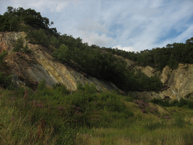
Quarry Wood nature reserve is a woodland on the west side of the A41 road at Hinstock in Shropshire that is managed by the Shropshire Wildlife Trust. Oak, birch and occasional hornbeam grow alongside swathes of rhododendron. The sandstone cliffs were formed in the Triassic period, around 220 million years ago, when this part of the country was hot and dry and dinosaurs were first emerging. The quarry may have provided the stone for the tower of St Oswald's church in the village and also some of the older houses, though quarrying ceased in the 1890s. The wood once provided cover for vast flocks of roosting thrushes and finches and, between 1966 and 1985, around 20,000 birds were ringed there. These birds no longer roost in such numbers, but the wood is home to a variety of birds including Eurasian jays, tits, Eurasian nuthatches, great spotted woodpecker The great spotted woodpecker (''Dendrocopos major'') is a medium-sized woodpecker with pied black and white plumage and a ... [...More Info...] [...Related Items...] OR: [Wikipedia] [Google] [Baidu] |
Visitor Centre
A visitor center or centre (see American and British English spelling differences), visitor information center or tourist information centre is a physical location that provides information to tourists. Types A visitor center may be a Civic center at a specific attraction or place of interest, such as a landmark, national park, national forest, or state park State parks are parks or other protected areas managed at the sub-national level within those nations which use "Federated state, state" as a political subdivision. State parks are typically established by a state to preserve a location on accou ..., providing information (such as trail maps, and about camp sites, staff contact, restrooms, etc.) and in-depth educational exhibits and artifact displays (for example, about natural or cultural history). Often a film or other media display is used. If the site has permit requirements or guided tours, the visitor center is often the place where these are coordinated. A tour ... [...More Info...] [...Related Items...] OR: [Wikipedia] [Google] [Baidu] |
Ludford, Shropshire
Ludford is a small village and civil parish in south Shropshire, England. The parish is situated adjacent to the market town of Ludlow and was, until 1895, partly in Herefordshire. The village is on the south bank of the River Teme, with Ludlow on the north bank, and is connected to the town by the grade I listed Ludford Bridge. The village is geologically notable with its Ludford Corner. History and geography Etymology The place name means the ford at the loud waters ("lud"); Ludlow's name means the hill ("low") by the loud waters. The loud waters are those of the River Teme, which flow rapidly through the area (now largely tamed by weirs). Domesday Book Ludford, Steventon, and the Sheet are all mentioned in the Domesday Book of 1086 as manors. They existed prior to the town of Ludlow, which grew up during or after the construction of the Norman castle there. Shropshire and Herefordshire Historically the parish was divided between Shropshire and Herefordshire and the vi ... [...More Info...] [...Related Items...] OR: [Wikipedia] [Google] [Baidu] |
Clun Forest
Clun Forest () is a remote, rural area of open pastures, moorland and mixed deciduous/coniferous woodland in the southwest part of the English county of Shropshire and also just over the border into Powys, Wales. It was once a Royal hunting forest covering an area that stretched from Ludlow up the Clun Valley. Set aside for hunting in mediaeval times, these areas were not necessarily heavily wooded, though in today's landscape there are numerous small woods, such as Radnor Wood, together with larger areas of conifer plantations established by the Forestry Commission along the Wales–England border north of Anchor for example (the planted Ceri Forest), and to the north and southeast of Clun. The ancient Offa's Dyke runs north–south through the area (and can be walked by the Offa's Dyke Path). It gives its name to a deanery of the Church of England's Diocese of Hereford. Geology The Forest is underlain by a succession of mudstones, sandstones and siltstones of Silurian a ... [...More Info...] [...Related Items...] OR: [Wikipedia] [Google] [Baidu] |
Church Stretton
Church Stretton is a market town and civil parish in Shropshire, England, south of Shrewsbury and north of Ludlow. The population in 2011 was 4,671.National Statistics Church Stretton 2011 population area and density The town was nicknamed Little Switzerland (landscape), Little Switzerland in the late Victorian era, Victorian and Edwardian era, Edwardian period for its landscape, and became a health resort. The local geology includes some of the oldest rocks in England and a notable Fault (geology), fault is named after the town. Church Stretton is in the Shropshire Hills AONB, Shropshire Hills Area of Outs ... [...More Info...] [...Related Items...] OR: [Wikipedia] [Google] [Baidu] |
Comley
Comley is a hamlet in Shropshire, England. It is near the A49 road, to the northeast of Church Stretton. It is situated between two prominent hills: Caer Caradoc to the south and The Lawley to the north. The elevation of the hamlet is around above sea level.Ordnance Survey mapping The hamlet is largely in the civil parish of Cardington, but Comley Farm is just within Longnor. Shropshire Wildlife Trust have a nature reserve in the former Comley Quarry. See also *Comley limestone The Comley Limestone is an Early Cambrian Lagerstätte exposed in Comley, Shropshire, England. It is known for its phosphatic microfossils, which can be extracted by acid maceration and are preserved in three dimensions in a similar fashion to ... References External links Hamlets in Shropshire Cardington, Shropshire {{Shropshire-geo-stub ... [...More Info...] [...Related Items...] OR: [Wikipedia] [Google] [Baidu] |
Clunton
Clunton is a village in south Shropshire, England, to the east of the small town of Clun. Location It lies on the B4368 road between Clun and Craven Arms. It is part of the civil parish of Clunbury. The nearest railway station is Hoptonheath. The village is at above sea level. The village centres on the B4368, though it branches southwards at Clunton Bridge (which crosses the River Clun). Near the centre is "The Crown" pub and St. Mary's Church. The Crown In 1994 the village public house, The Crown, was threatened with closure. A group of locals clubbed together and bought it, rather than lose it altogether . They still own it today. The pub is co-owned by 30 people, mostly locals. It remains a traditional country pub, with a selection of local real ales; The Crown has an entry in the CAMRA ''Good Beer Guide'' 2015. Clunton Coppice Nearby to the south of the village is Clunton Coppice, a remnant of the oak coppice woodland which was abundant in this part of Shropshi ... [...More Info...] [...Related Items...] OR: [Wikipedia] [Google] [Baidu] |
Catherton Common
Catherton Common is a nature reserve of the Shropshire Wildlife Trust, between Cleehill and Cleobury Mortimer in Shropshire, England. It is heathland, designated a Site of Special Scientific Interest. ''''. Retrieved 30 September 2021. Description The area of the reserve is ; it is an uncultivated landscape, in which houses and smallholdings are dispersed. There is heather, including , and |
The Ercall
The Ercall is a small hill in Shropshire, England, between The Wrekin and Wellington. It is an internationally important geological site, part of The Wrekin and The Ercall Site of Special Scientific Interest (SSSI). The hill is managed by Shropshire Wildlife Trust and includes 540 million year old ripple beds and ancient pre-Cambrian lava flows in exposed quarries. Quartzite from the neighbouring Wrekin is also visible. The Ercall bears the marks of extensive quarrying, although the quarries are now disused, safe and open to the public. When the M54 motorway was constructed in 1974, the road was built through the northern end of the hill. Flora and fauna The woods of the forest are important for various butterfly species. In the summer, the Ercall Woods which line the hill are a favourite habitat for the speckled wood and during spring when the forest is laden with bluebells, the dingy skipper can arrive in great numbers. The exposed quarries are popular with other butterfly ... [...More Info...] [...Related Items...] OR: [Wikipedia] [Google] [Baidu] |
Stiperstones
The Stiperstones () is a distinctive hill in Shropshire, England. The quartzite rock of the ridge formed some 480 million years ago. During the last Ice Age Stiperstones lay on the eastern margin of the Welsh ice sheet. The hill itself was not glaciated though glaciers occupied surrounding valleys and it was subject to intense freezing and thawing which shattered the quartzite into a mass of jumbled scree surrounding several residual rocky tors. At above sea level it is the second-highest hill in the county, surpassed only by Brown Clee Hill (). Stiperstones' summit ridge is crowned by several jagged outcrops of rock, which may be seen silhouetted against the sky. Geography The Stiperstones is noted for its tors of quartzite. The principal ones are named as follows, from north-east to south-west: * Shepherd's Rock () * Devil's Chair () * Manstone Rock () * Cranberry Rock () * Nipstone Rock () * The Rock () Manstone Rock is the highest of these at , and is topped with a t ... [...More Info...] [...Related Items...] OR: [Wikipedia] [Google] [Baidu] |


