|
Shokalskogo Island
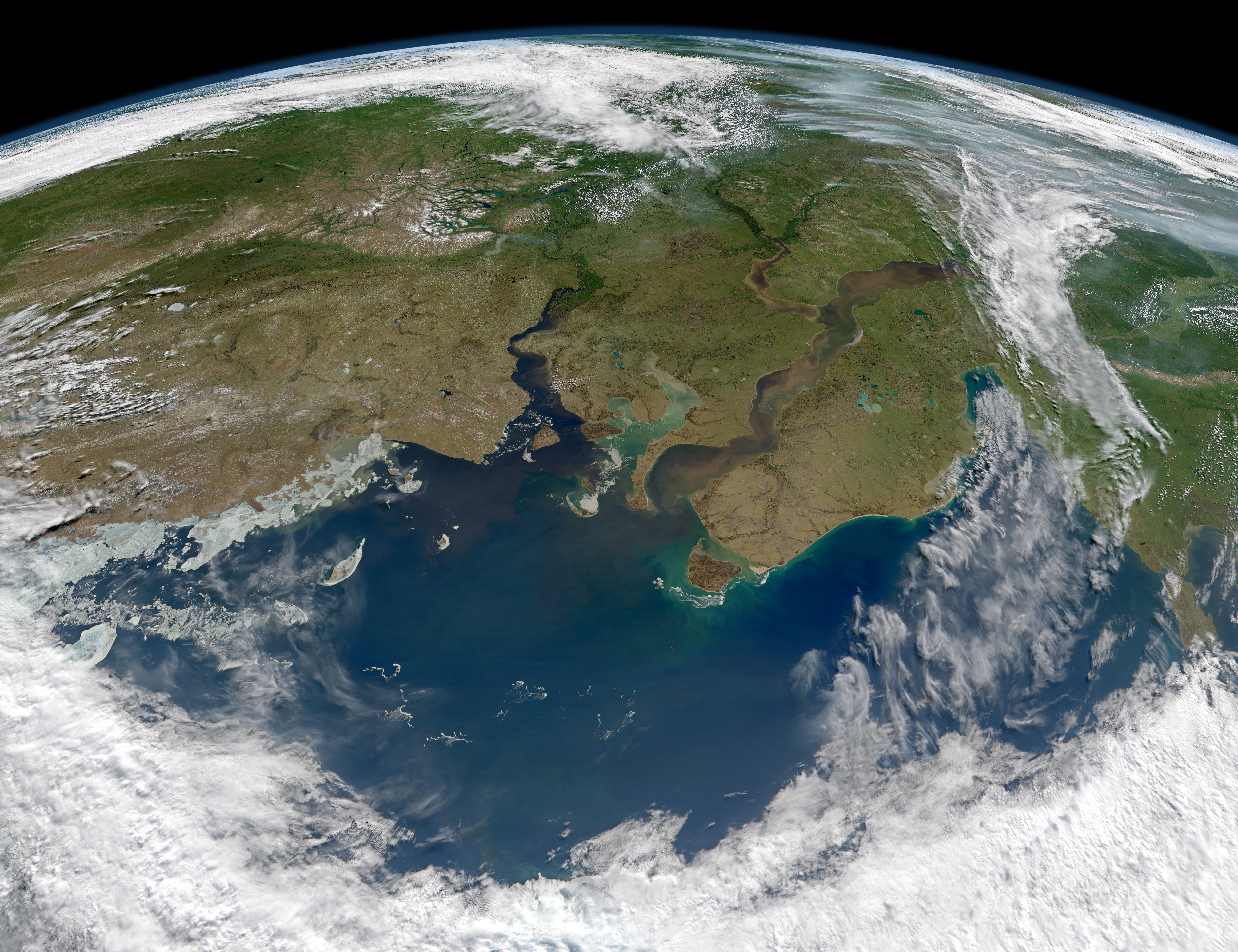
Shokalsky Island () is an island in the Kara Sea, in Russia. It is located on the eastern side of the mouth of the Ob River, off the tip of the narrow northwestern arm of the Gyda Peninsula. It is separated from it by a narrow strait full of islets known as Gydanskiy Proliv. Its latitude is 72° 58' N and its longitude 74° 27' E. The island has an area of 428 km2 and it is covered by tundra. The sea surrounding the island is covered with pack ice in the winter and there are numerous ice floes even in the summer, so that it is often merged with the Gydanskiy Peninsula in the Siberian mainland. This island belongs to the Yamalo-Nenets Autonomous Okrug which is the northern part of the Tyumen Oblast administrative division of the Russian Federation. This island is also part of the Great Arctic State Nature Reserve, the largest nature reserve of Russia. This island was named after Imperial Russian cartographer Yuly Shokalsky. Shokalsky Island should not be confused with a l ... [...More Info...] [...Related Items...] OR: [Wikipedia] [Google] [Baidu] |
Kara SeaSL
Kara or KARA may refer to: Geography Localities * Kara, Chad, a sub-prefecture * Kára, Hungary, a village * Kara, Uttar Pradesh, India, a township * Kara, Iran, a village in Lorestan Province * Kara, Republic of Dagestan, a rural locality in Dagestan, Russia * Kara, Sardauna, a village in Sardauna, Nigeria * Kara, Bougainville, a town on Bougainville Island in Papua New Guinea * Kara, Togo, a city in northern Togo ** Kara Region ** Roman Catholic Diocese of Kara, Togo * Gaya confederacy or Kara, a former confederation in the southern Korean peninsula * Kara crater, a meteorite crater in northern Russia Rivers, Seas * Kara (river), a river in northern Russia, flowing into the Kara Sea * Kara River (other), other rivers named Kara * Kara Lake, Bolivia * Kara Sea, a sea in the Arctic Ocean * Kara Strait, a strait in Russia People * Kara (name), a surname and given name, and a list of people with the name * Kara people, an ethnic group in South Sudan, exceeding 100,0 ... [...More Info...] [...Related Items...] OR: [Wikipedia] [Google] [Baidu] |
Kara Sea
The Kara Sea is a marginal sea, separated from the Barents Sea to the west by the Kara Strait and Novaya Zemlya, and from the Laptev Sea to the east by the Severnaya Zemlya archipelago. Ultimately the Kara, Barents and Laptev Seas are all extensions of the Arctic Ocean north of Siberia. The Kara Sea's northern limit is marked geographically by a line running from Cape Kohlsaat in Graham Bell Island, Franz Josef Land, to Cape Molotov (Arctic Cape), the northernmost point of Komsomolets Island in Severnaya Zemlya. The Kara Sea is roughly long and wide with an area of around and a mean depth of . Its main ports are Novy Port and Dikson and it is important as a fishing ground although the sea is ice-bound for all but two months of the year. The Kara Sea contains the East-Prinovozemelsky field (an extension of the West Siberian Oil Basin), containing significant undeveloped petroleum and natural gas. In 2014, US government sanctions resulted in Exxon having unti ... [...More Info...] [...Related Items...] OR: [Wikipedia] [Google] [Baidu] |
Russia
Russia, or the Russian Federation, is a country spanning Eastern Europe and North Asia. It is the list of countries and dependencies by area, largest country in the world, and extends across Time in Russia, eleven time zones, sharing Borders of Russia, land borders with fourteen countries. Russia is the List of European countries by population, most populous country in Europe and the List of countries and dependencies by population, ninth-most populous country in the world. It is a Urbanization by sovereign state, highly urbanised country, with sixteen of its urban areas having more than 1 million inhabitants. Moscow, the List of metropolitan areas in Europe, most populous metropolitan area in Europe, is the capital and List of cities and towns in Russia by population, largest city of Russia, while Saint Petersburg is its second-largest city and Society and culture in Saint Petersburg, cultural centre. Human settlement on the territory of modern Russia dates back to the ... [...More Info...] [...Related Items...] OR: [Wikipedia] [Google] [Baidu] |
Ob River
The Ob (; ) is a major river in Russia. It is in western Siberia, and with its tributary the Irtysh forms the world's seventh-longest river system, at . The Ob forms at the confluence of the Biya and Katun which have their origins in the Altai Mountains. It is the westernmost of the three great Siberian rivers that flow into the Arctic Ocean (the other two being the Yenisei and the Lena). Its flow is north-westward, then northward. The main city on its banks is Novosibirsk, the largest city in Siberia, and the third-largest city in Russia. It is where the Trans-Siberian Railway crosses the river. The Gulf of Ob is the world's longest estuary. Names The internationally known name of the river is based on the Russian name ''Обь'' (''Obʹ'', ). Possibly from Proto-Indo-Iranian '' *Hā́p-'', "river, water" (compare Vedic Sanskrit ''áp-'', Persian ''āb'', Tajik ''ob'', and Pashto ''obə'', "water"). Katz (1990) proposes Komi ''ob'' 'river' as the immediate source of ... [...More Info...] [...Related Items...] OR: [Wikipedia] [Google] [Baidu] |
Gyda Peninsula
The Gyda Peninsula () is a geographical feature of the Siberian coast in the Kara Sea. It takes its name from the river Gyda, that flows on the peninsula. It is roughly 400 km long and 360 km wide. This wide peninsula lies between the estuaries of the Ob (Gulf of Ob) and Yenisei Rivers ( Yenisei Gulf). The southwestern corner of the peninsula is limited by the Taz Estuary, and across the river lies the Yamal Peninsula. The climate in the whole area is arctic and harsh. Geography The Gyda Peninsula is mostly flat, with numerous lakes and rivers. Tanama has its sources in the peninsula.Танама, Great Soviet Encyclopedia in 30 vols. / Ch. ed. A.M. Prokhorov – 3rd ed. – M, 1969–1978. Its ground consists of permafrost and is covered by tundra. This peninsula has a few arms or subpeninsulas extending northwards into the Kara Sea, where there are some large islands off its shores, including Oleniy, Shokalsky and Vilkitsky Islands. There are two bays in its n ... [...More Info...] [...Related Items...] OR: [Wikipedia] [Google] [Baidu] |
Yamalo-Nenets Autonomous Okrug
The Yamalo-Nenets Autonomous Okrug (; ) also known as Yamalia () is a federal subject of Russia and an autonomous okrug of Tyumen Oblast. Its administrative center is the town of Salekhard, and its largest city is Novy Urengoy. The 2021 Russian Census recorded its population as 510,490. The autonomous okrug borders Krasnoyarsk Krai to the east, the Khanty-Mansi Autonomous Okrug to the south, and the Nenets Autonomous Okrug and Komi Republic to the west. Geography The West Siberian petroleum basin is the largest hydrocarbon (petroleum and natural gas) basin in the world covering an area of about 2.2 million km2, and is also the largest oil and gas producing region in Russia. The Nenets people are an indigenous tribe who have long survived in this region. Their prehistoric life involved subsistence hunting and gathering, including the taking of polar bears; the practice of hunting polar bears (''Ursus maritimus'') continues up to the present time. Yamalo-Nenets Autonomous Okr ... [...More Info...] [...Related Items...] OR: [Wikipedia] [Google] [Baidu] |
Tyumen Oblast
Tyumen Oblast () is a federal subjects of Russia, federal subject (an oblast) of Russia. It is located in Western Siberia, and is administratively part of the Ural Federal District. The oblast has administrative jurisdiction over two autonomous okrugs of Russia, autonomous okrugs: the Khanty-Mansi Autonomous Okrug, Khanty-Mansi and Yamalo-Nenets Autonomous Okrug. The oblast, including its autonomous okrugs, is the third-largest federal subject by area, and has a population of 3,395,755 (Russian Census (2010), 2010). (The rank is given without the autonomous okrugs' populations; the population and percentages are given for the territory of the oblast with the autonomous okrugs) Tyumen is the largest types of inhabited localities in Russia, city and the Administrative centre, administrative center of the oblast, and the first Russian settlement east of the Ural Mountains. Tyumen Oblast is the largest producer of oil and natural gas in the country, and has experienced an oil boom ... [...More Info...] [...Related Items...] OR: [Wikipedia] [Google] [Baidu] |
Russian Federation
Russia, or the Russian Federation, is a country spanning Eastern Europe and North Asia. It is the list of countries and dependencies by area, largest country in the world, and extends across Time in Russia, eleven time zones, sharing Borders of Russia, land borders with fourteen countries. Russia is the List of European countries by population, most populous country in Europe and the List of countries and dependencies by population, ninth-most populous country in the world. It is a Urbanization by sovereign state, highly urbanised country, with sixteen of its urban areas having more than 1 million inhabitants. Moscow, the List of metropolitan areas in Europe, most populous metropolitan area in Europe, is the capital and List of cities and towns in Russia by population, largest city of Russia, while Saint Petersburg is its second-largest city and Society and culture in Saint Petersburg, cultural centre. Human settlement on the territory of modern Russia dates back to the ... [...More Info...] [...Related Items...] OR: [Wikipedia] [Google] [Baidu] |
Great Arctic State Nature Reserve
The Great Arctic State Nature Reserve () is a nature reserve in Krasnoyarsk Krai, Russia. With an area of , it is the largest reserve of Russia and Eurasia, as well as one of the largest in the world. History The Great Arctic State Nature Reserve was founded on May 11, 1993 by Resolution No.431 of the Government of the Russian Federation. The Nature Reserves in Russia are known as ''zapovedniks''. Topography The Great Arctic State Nature Reserve is divided into nine sections: * Dikson - Sibiryakov section. *The Kara Sea Islands section, with a surface of . It includes the Sergei Kirov Islands, the Voronina Island, the Izvestiy TSIK Islands, the Arkticheskiy Institut Islands, the Sverdrup Island, the Uyedineniya Island and a number of smaller islands. This section represents rather fully the natural and biological diversity of Arctic Sea islands of the eastern part of the Kara Sea. *The Pyasina section. Includes the Pyasina Bay and the Pyasina river basin. *The Middendorff ... [...More Info...] [...Related Items...] OR: [Wikipedia] [Google] [Baidu] |
Yuly Shokalsky
Yuly Mikhailovich Shokalsky (; October 17, 1856 in Saint Petersburg – March 26, 1940 in Leningrad) was a Russian Empire and Soviet oceanographer, cartographer, and geographer. Career A grandson of Anna Kern, Pushkin's celebrated mistress, Shokalsky graduated from the Naval Academy in 1880 and made a career in the Imperial Russian Navy, helping establish the Sevastopol Marine Observatory and rising to the rank of Lieutenant-General in 1912. At the same time, he developed interest in limnology and meteorology and became the most prolific Russian author on the subjects. In the ''Marine Miscellanies'' alone, he published some 300 articles. Shokalsky's most important monograph was ''Oceanography'' (1917), a collection of his lectures which examined connection between meteorology and hydrology and emphasized the importance of monitoring marine phenomena in order to understand global changes of climate. Shokalsky insisted on differentiating oceanography and hydrography and co ... [...More Info...] [...Related Items...] OR: [Wikipedia] [Google] [Baidu] |
Vaygach Island
Vaygach Island () is an island in the Arctic Sea between the Pechora Sea and the Kara Sea. Geography Vaygach Island is separated from the Yugorsky Peninsula in the mainland by the Yugorsky Strait and from Novaya Zemlya by the Kara Strait. The island is a part of Nenets Autonomous Okrug of Arkhangelsk Oblast, Russia. * Area: * Length: ~ * Width: up to * Average temperatures: (February), (June) * Highest point: Vaygach Island is mainly formed of argillaceous slates, sandstone, and limestone. There are many rivers about in length, swamps, and small lakes on the island. For the most part it consists of tundra. Slight rocky ridges run generally along its length, and the coast has low cliffs in places. The island consists mostly of limestone, and its elevation above the sea is geologically recent. Raised beaches are frequent. The rocks are heavily scored by ice, but this was probably marine ice, not that of glaciers. The only settlement on the island is Varnek. Environm ... [...More Info...] [...Related Items...] OR: [Wikipedia] [Google] [Baidu] |


