|
Shahr-e Bozorg
Shahr-e Bozorg is a village and the district capital of Shahri Buzurg District, in Badakhshan Province in north-eastern Afghanistan. During May 1998 this village was at the epicentre of a large earthquake. Support was provided by helicopter and donkey convoy due to the inaccessibility of the area. Medical and emergency food support was provided by a consortium of the Northern Alliance Government and International NGOs assisted by UNOCHA from Faizabad, at that time the capital of the Northern Alliance held area of Afghanistan. Climate Shahr-e Bozorg has a humid continental climate (Köppen ''Dsb''). See also *Badakhshan Province Badakhshan Province (Dari: بدخشان) is one of the 34 provinces of Afghanistan, located in the northeastern part of the country. It is bordered by Tajikistan's Gorno-Badakhshan in the north and the Pakistani regions of Lower and Upper C ... References External linksSatellite map at Maplandia.com Populated places in Badakhshan Province [...More Info...] [...Related Items...] OR: [Wikipedia] [Google] [Baidu] |
Village
A village is a human settlement or community, larger than a hamlet but smaller than a town with a population typically ranging from a few hundred to a few thousand. Although villages are often located in rural areas, the term urban village is also applied to certain urban neighborhoods. Villages are normally permanent, with fixed dwellings; however, transient villages can occur. Further, the dwellings of a village are fairly close to one another, not scattered broadly over the landscape, as a dispersed settlement. In the past, villages were a usual form of community for societies that practice subsistence agriculture and also for some non-agricultural societies. In Great Britain, a hamlet earned the right to be called a village when it built a church.-4; we might wonder whether there's a point at which it's appropriate to talk of the beginnings of French, that is, when it wa ... ''village'', from Latin ''villāticus'', ultimately from Latin ''villa'' (English ''vi ... [...More Info...] [...Related Items...] OR: [Wikipedia] [Google] [Baidu] |
Districts Of Afghanistan
The districts of Afghanistan, known as ''wuleswali'' (, ''wuləswāləi''; , ''wuləswālī''; ''ulasvolik''), are secondary-level administrative units, one level below Provinces of Afghanistan, provinces. The Afghan government issued its first district map in 1973. It recognized 325 districts, counting ''wuleswalis'' (districts), ''alaqadaries'' (sub-districts), and ''markaz-e-wulaiyat'' (provincial center districts). In the ensuing years, additional districts have been added through splits, and some eliminated through merges. In June 2005, the Afghan government issued a map of 398 districts. It was widely adopted by many information management systems, though usually with the addition of ''Sharak-e-Hayratan'' for 399 districts in total. It remains the ''de facto'' standard as of late 2018, despite a string of government announcements of the creation of new districts. The latest announced set includes 421 districts. The country's Central Statistics Office (CSO) and the Indepe ... [...More Info...] [...Related Items...] OR: [Wikipedia] [Google] [Baidu] |
Shahri Buzurg District
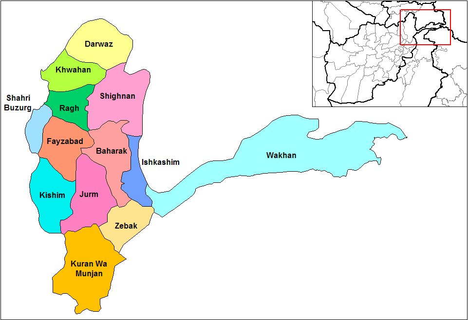
Shahr-e-Bozorg (; meaning Great City) is one of the 28 districts of Badakhshan province in northeastern Afghanistan. According to latest estimates, approximately 67,000 people live in the district. The district of Shahr-e-Bozorg is located in the western part of the province, east of Takhar Province and south of the Afghanistan–Tajikistan border. To the northeast is Yawan District, to the east is Yaftali Sufla District and to the southeast is Argo District. Shahr-e-Bozorg along with the surrounding and nearby districts were affected by the 2005 Hindu Kush earthquake. The district also deals with heavy snow and occasional avalanche during winter seasons. See also * Districts of Afghanistan The districts of Afghanistan, known as ''wuleswali'' (, ''wuləswāləi''; , ''wuləswālī''; ''ulasvolik''), are secondary-level administrative units, one level below Provinces of Afghanistan, provinces. The Afghan government issued its fir ... References External links * ... [...More Info...] [...Related Items...] OR: [Wikipedia] [Google] [Baidu] |
Badakhshan Province
Badakhshan Province (Dari: بدخشان) is one of the 34 provinces of Afghanistan, located in the northeastern part of the country. It is bordered by Tajikistan's Gorno-Badakhshan in the north and the Pakistani regions of Lower and Upper Chitral and Gilgit-Baltistan in the southeast. The province also has Afghanistan's only border with China spanning 91 kilometers (57 miles) in the eastern side of the province via its Wakhan District. It is part of a broader historical Badakhshan region, parts of which now also lie in Tajikistan and China. The province contains 22 districts, over 1,200 villages and approximately 1,055,000 people. Fayzabad serves as the provincial capital. Resistance activity has been reported in the province since the 2021 Taliban takeover of Afghanistan. Etymology During the Sassanids' reign it was called "bidix", and in Parthian times "bthšy". In Sassanid manuscripts found in Ka'ba-ye Zartosht it was called "Bałasakan". In Chinese sources fro ... [...More Info...] [...Related Items...] OR: [Wikipedia] [Google] [Baidu] |
Afghanistan
Afghanistan, officially the Islamic Emirate of Afghanistan, is a landlocked country located at the crossroads of Central Asia and South Asia. It is bordered by Pakistan to the Durand Line, east and south, Iran to the Afghanistan–Iran border, west, Turkmenistan to the Afghanistan–Turkmenistan border, northwest, Uzbekistan to the Afghanistan–Uzbekistan border, north, Tajikistan to the Afghanistan–Tajikistan border, northeast, and China to the Afghanistan–China border, northeast and east. Occupying of land, the country is predominantly mountainous with plains Afghan Turkestan, in the north and Sistan Basin, the southwest, which are separated by the Hindu Kush mountain range. Kabul is the country's capital and largest city. Demographics of Afghanistan, Afghanistan's population is estimated to be between 36 and 50 million. Ancient history of Afghanistan, Human habitation in Afghanistan dates to the Middle Paleolithic era. Popularly referred to as the graveyard of empire ... [...More Info...] [...Related Items...] OR: [Wikipedia] [Google] [Baidu] |
National Geospatial-Intelligence Agency
The National Geospatial-Intelligence Agency (NGA) is a combat support agency within the United States Department of Defense whose primary mission is collecting, analyzing, and distributing geospatial intelligence (GEOINT) to support national security. Founded in 1996 as the National Imagery and Mapping Agency (NIMA), it changed names in 2003. It is a member of the United States Intelligence Community. NGA headquarters, also known as NGA Campus East or NCE, is located at Fort Belvoir North Area in Springfield, Virginia. At , it is the third-largest government building in the Washington metropolitan area after the Pentagon and the Ronald Reagan Building and International Trade Center, Ronald Reagan Building. The agency also operates NGA Campus West, or NCW, in St. Louis, Missouri, and support and liaison offices worldwide. NGA also helps respond to natural and manmade disasters, helps with security planning for major events such as the Olympic Games, disseminates maritime safety ... [...More Info...] [...Related Items...] OR: [Wikipedia] [Google] [Baidu] |
Provinces Of Afghanistan
The provinces of Afghanistan ( ''Wilayah, wilāyat'') are the primary administrative divisions. Afghanistan is divided into 34 provinces. Each province encompasses a number of Districts of Afghanistan, districts or usually over 1,000 villages. Provincial governors played a critical role in the reconstruction of the Afghan state following the creation of the new government under Hamid Karzai. According to international security scholar Dipali Mukhopadhyay, many of the provincial governors of the western-backed government were former warlords who were incorporated into the political system. Provinces of Afghanistan Administrative The following table lists the province, capital, number of districts, UN region, region, ISO 3166-2:AF code and license plate code. Demographic The following table lists the province, population in 2024, area in square kilometers and population density. Regions of Afghanistan The following tables summarize data from the demographic ... [...More Info...] [...Related Items...] OR: [Wikipedia] [Google] [Baidu] |
Humid Continental Climate
A humid continental climate is a climatic region defined by Russo-German climatologist Wladimir Köppen in 1900, typified by four distinct seasons and large seasonal temperature differences, with warm to hot (and often humid) summers, and cold (sometimes severely cold in the northern areas) and snowy winters. Precipitation is usually distributed throughout the year, but often these regions do have dry seasons. The definition of this climate in terms of temperature is as follows: the mean temperature of the coldest month must be below or depending on the isotherm, and there must be at least four months whose mean temperatures are at or above . In addition, the location in question must not be semi-arid or arid. The cooler ''Dfb'', ''Dwb'', and ''Dsb'' subtypes are also known as hemiboreal climates. Although amount of snowfall is not a factor used in defining the humid continental climate, snow during the winter in this type of climate is almost a guarantee, either intermitte ... [...More Info...] [...Related Items...] OR: [Wikipedia] [Google] [Baidu] |
Köppen Climate Classification
The Köppen climate classification divides Earth climates into five main climate groups, with each group being divided based on patterns of seasonal precipitation and temperature. The five main groups are ''A'' (tropical), ''B'' (arid), ''C'' (temperate), ''D'' (continental), and ''E'' (polar). Each group and subgroup is represented by a letter. All climates are assigned a main group (the first letter). All climates except for those in the ''E'' group are assigned a seasonal precipitation subgroup (the second letter). For example, ''Af'' indicates a tropical rainforest climate. The system assigns a temperature subgroup for all groups other than those in the ''A'' group, indicated by the third letter for climates in ''B'', ''C'', ''D'', and the second letter for climates in ''E''. Other examples include: ''Cfb'' indicating an oceanic climate with warm summers as indicated by the ending ''b.'', while ''Dwb'' indicates a semi-Monsoon continental climate, monsoonal continental climate ... [...More Info...] [...Related Items...] OR: [Wikipedia] [Google] [Baidu] |


