|
Sespe Hot Springs
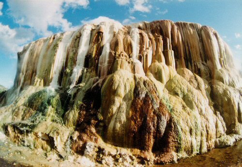
Sespe Hot Springs (Chumash: S'eqp'e') are a system of thermal springs and seeps that form a hot spring creek in the mountains near the Sespe Condor Sanctuary near Ojai, California. Description The hot springs were used for centuries by local indigenous people for their warmth and healing properties. The hot springs and hot creek are located in a remote desert mountainous area in Los Padres National Forest. The hot mineral water emerges from the ground at 194 °F / 90 °C through a series of seeps that flows down a hillside, cooling as it enters several primitive, rock and boulder-lined soaking pools. The temperature of the water cools as it mixes with cool water from a creek. Several seeps along the creekside emerge at cooler temperatures than the main springs. At the site, there is also a primitive rock sauna, and a hot waterfall. Location The hot springs are located 20 miles northeast of Sespe Creek canyon, approximately 20 miles from Matilija Canyon and 15 miles so ... [...More Info...] [...Related Items...] OR: [Wikipedia] [Google] [Baidu] |
Chumashan Languages
Chumashan is an extinct and revitalizing family of languages that were spoken on the southern California West Coast of the United States, coast by Native Americans in the United States, Native American Chumash people, from the Coastal plains and valleys of San Luis Obispo, California, San Luis Obispo to Malibu, California, Malibu, neighboring inland and Transverse Ranges valleys and canyons east to bordering the San Joaquin Valley, to three adjacent Channel Islands of California, Channel Islands: San Miguel Island, San Miguel, Santa Rosa Island, California, Santa Rosa, and Santa Cruz Island, Santa Cruz. The Chumashan languages may be, along with Yukian languages, Yukian and perhaps languages of southern Baja California such as Waikuri language, Waikuri, one of the oldest language families established in California, before the arrival of speakers of Penutian, Uto-Aztecan, and perhaps even Hokan languages. Chumashan, Yukian, and southern Baja languages are spoken in areas with lon ... [...More Info...] [...Related Items...] OR: [Wikipedia] [Google] [Baidu] |
Thermal Springs
A hot spring, hydrothermal spring, or geothermal spring is a spring produced by the emergence of geothermally heated groundwater onto the surface of the Earth. The groundwater is heated either by shallow bodies of magma (molten rock) or by circulation through faults to hot rock deep in the Earth's crust. Hot spring water often contains large amounts of dissolved minerals. The chemistry of hot springs ranges from acid sulfate springs with a pH as low as 0.8, to alkaline chloride springs saturated with silica, to bicarbonate springs saturated with carbon dioxide and carbonate minerals. Some springs also contain abundant dissolved iron. The minerals brought to the surface in hot springs often feed communities of extremophiles, microorganisms adapted to extreme conditions, and it is possible that life on Earth had its origin in hot springs. Humans have made use of hot springs for bathing, relaxation, or medical therapy for thousands of years. However, some are hot enough that im ... [...More Info...] [...Related Items...] OR: [Wikipedia] [Google] [Baidu] |
Sespe Condor Sanctuary
The Sespe Condor Sanctuary is a wildlife refuge in the Topatopa Mountains, in northeastern Ventura County, California, Ventura County, California. It is within the Sespe Wilderness in the southern Los Padres National Forest. History The United States Forest Service established the Sespe Condor Sanctuary in 1947 for the California condor, an endangered species which is the largest living bird in North America. On January 14, 1992, two captive-bred California condors and two Andean condors were released into the Sespe Condor Sanctuary, overlooking the Sespe Creek, near Fillmore, California. This was done by the United States Fish and Wildlife Service, U.S. Fish and Wildlife Service's Hopper Mountain National Wildlife Refuge Complex, the lead office for the California Condor Recovery Program. These captive-bred condors thrived in the wild and have begun to Reproduction, reproduce freely. Before the sanctuary was established, numerous condors were killed by Electric power transmis ... [...More Info...] [...Related Items...] OR: [Wikipedia] [Google] [Baidu] |
Ojai, California
Ojai ( ; Chumashan languages, Chumash: ''’Awhaỳ'') is a city in Ventura County, California. Located in the Ojai Valley, it is northwest of Los Angeles and east of Santa Barbara, California, Santa Barbara. The valley is part of the east–west trending Western Transverse Ranges and is about long by wide and divided into a lower and an upper valley, each of similar size, surrounded by hills and mountains. The population was 7,637 at the 2020 United States census, 2020 census, up from 7,461 at the 2010 United States Census, 2010 census. Ojai is known for its boutique hotels, recreation opportunities, hiking, and farmers' market of local organic agriculture. It has small businesses specializing in local and ecologically friendly art, design, and home improvement. Chain stores are prohibited by city ordinance to encourage local small business development and retain the town's character. The name Ojai is derived from the Mexican-era Rancho Ojai, which in turn took its name fr ... [...More Info...] [...Related Items...] OR: [Wikipedia] [Google] [Baidu] |
Los Padres National Forest
Los Padres National Forest is a United States national forest in Southern California, southern and central California. Administered by the United States Forest Service, Los Padres includes most of the mountainous land along the California coast from Ventura, California, Ventura to Monterey, California, Monterey, extending inland. Elevations range from sea level to . Geography The forest is approximately in area, of which or about 88% are public lands; the rest are privately owned inholdings. The forest is divided into two non-contiguous areas separated approximately from one another. The northern division lies within Monterey County, California, Monterey County and includes the Big Sur, Big Sur Coast and its scenic interior areas. This is a very popular area for hiking, with of hiking trails and 11 campsite, campgrounds (ranging from very rugged to suitable for recreational vehicles). The larger, so called main section of Los Padres lies further south, within San Luis O ... [...More Info...] [...Related Items...] OR: [Wikipedia] [Google] [Baidu] |
Sespe Creek
Sespe Creek (Chumashan languages, Chumash: S'eqp'e', "Kneecap") is a stream, some long,U.S. Geological Survey. National Hydrography Dataset high-resolution flowline dataThe National Map accessed March 16, 2011 in Ventura County, California, Ventura County, southern California, in the Western United States. The creek starts at Potrero Seco in the eastern Sierra Madre Mountains (California), Sierra Madre Mountains, and is formed by more than thirty tributary streams of the Sierra Madre and Topatopa Mountains, before it empties into the Santa Clara River (California), Santa Clara River in Fillmore, California, Fillmore. Thirty-one miles (50 km) of Sespe Creek is designated as a National Wild and Scenic River and National Scenic Waterway, and is untouched by dams or concrete channels. It is one of the last wild rivers in Southern California. It is primarily within the southern Los Padres National Forest. The name Sespe can be traced to a Chumash people, Chumash Indian village ... [...More Info...] [...Related Items...] OR: [Wikipedia] [Google] [Baidu] |
Matilija Creek
Matilija Creek ( ) is a major stream in Ventura County in the U.S. state of California. It joins with North Fork Matilija Creek to form the Ventura River. Many tributaries feed the mostly free flowing, creek,U.S. Geological Survey. National Hydrography Dataset high-resolution flowline dataThe National Map, accessed March 16, 2011 which is largely contained in the Matilija Wilderness. Matilija was one of the Chumash rancherias under the jurisdiction of Mission San Buenaventura. The meaning of the Chumash name is unknown. Course From its headwaters south of Sespe Creek in the Matilija Wilderness in Santa Barbara County, the creek flows east then south through a narrow V-shaped canyon into Ventura County. Below Matilija Falls it turns east and receives the Upper North Fork from the left, and almost immediately below that the West Fork (Murietta Canyon) from the right. The creek then flows east through a wider valley along the north side of the Santa Ynez Mountains before it emptie ... [...More Info...] [...Related Items...] OR: [Wikipedia] [Google] [Baidu] |
San Andreas Fault
The San Andreas Fault is a continental Fault (geology)#Strike-slip faults, right-lateral strike-slip transform fault that extends roughly through the U.S. state of California. It forms part of the tectonics, tectonic boundary between the Pacific plate and the North American plate. Traditionally, for scientific purposes, the fault has been classified into three main segments (northern, central, and southern), each with different characteristics and a different degree of earthquake risk. The average slip rate along the entire fault ranges from per year. In the north, the fault terminates offshore near Eureka, California, at the Mendocino triple junction, where three tectonic plates meet. The Cascadia subduction zone intersects the San Andreas fault at the Mendocino triple junction. It has been hypothesized that a major earthquake along the Cascadia subduction zone could trigger a rupture along the San Andreas Fault. In the south, the fault terminates near Bombay Beach, Califor ... [...More Info...] [...Related Items...] OR: [Wikipedia] [Google] [Baidu] |
HathiTrust
HathiTrust Digital Library is a large-scale collaborative repository of digital content from research libraries. Its holdings include content digitized via Google Books and the Internet Archive digitization initiatives, as well as content digitized locally by libraries. Etymology ''Hathi'' (), derived from the Sanskrit , is the Hindi word for 'elephant', an animal famed for its long-term memory. History HathiTrust was founded in October 2008 by the twelve universities of the Committee on Institutional Cooperation and the eleven libraries of the University of California. As of 2024, members include more than 219 research libraries across the United States, Canada, and Europe, and is based on a shared governance structure. Costs are shared by the participating libraries and library consortia. The repository is administered by the University of Michigan. The executive director of HathiTrust is Mike Furlough, who succeeded founding director John Wilkin after Wilkin stepped down ... [...More Info...] [...Related Items...] OR: [Wikipedia] [Google] [Baidu] |
Willett Hot Springs
Willett Hot Springs is located in the Sespe Wilderness, North of Ojai, California. This natural hot spring has been augmented by a man made collection basin. The most popular approach to the hot spring is by an approximate hike from the Piedra Blanca trailhead in Los Padres National Forest. Nearby Sespe Hot Springs (about ) has a reputation as one of the hottest springs in California.Martin, Hugo (December 7, 2008"Sespe Hot Springs in Ventura County: a hot time in the wilderness"''Los Angeles Times'' External links USDA: Los Padres National Forest Hot Springs References {{reflist Hot springs of California Los Padres National Forest Springs of Ventura County, California ... [...More Info...] [...Related Items...] OR: [Wikipedia] [Google] [Baidu] |


