|
Seluma Regency
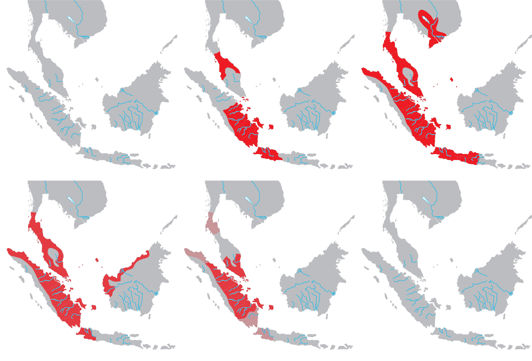
Seluma Regency is a regency of Bengkulu Province, Indonesia, on the west coast of the island of Sumatra. It was created on 25 February 2003 from what were formerly the northwestern districts of the South Bengkulu Regency. The regency seat is at the town of Pasar Tais. It covers an area of 2,479.36 km2, and had a population of 173,507 at the 2010 CensusBiro Pusat Statistik, Jakarta, 2011. and 207,877 at the 2020 Census;Badan Pusat Statistik, Jakarta, 2021. the official estimate as at mid 2022 was 213,755 (comprising 110,118 males and 103,637 females).Badan Pusat Statistik, Jakarta, 2023, ''Kabupaten Seluma Dalam Angka 2023'' (Katalog-BPS 1102001.1705) Bordering areas The regency borders South Bengkulu Regency to the southeast, the Indian Ocean to the southwest, Bengkulu (city) and Central Bengkulu Regency to the northwest, and South Sumatra Province (Empat Lawang Regency and Lahat Regency) to the northeast. Administrative districts The Regency is divided into fourteen districts ... [...More Info...] [...Related Items...] OR: [Wikipedia] [Google] [Baidu] |
List Of Regencies And Cities Of Indonesia
Regencies (''kabupaten'') and cities (''kota'') are the second-level administrative subdivision in Indonesia, immediately below the provinces, and above the districts. Regencies are roughly equivalent to American counties, although most cities in the United States are below the counties. Following the implementation of decentralization beginning on 1 January 2001, regencies and city municipalities became the key administrative units responsible for providing most governmental services. Each of regencies and cities has their own local government and legislative body. The difference between a regency and a city lies in demography, size, and economy. Generally, a regency comprises a rural area larger than a city, but also often includes various towns. A city usually has non-agricultural economic activities. A regency is headed by a regent (''bupati''), while a city is headed by a mayor (''wali kota''). All regents, mayors, and members of legislatures are directly elected via el ... [...More Info...] [...Related Items...] OR: [Wikipedia] [Google] [Baidu] |
Indian Ocean
The Indian Ocean is the third-largest of the world's five oceanic divisions, covering or ~19.8% of the water on Earth's surface. It is bounded by Asia to the north, Africa to the west and Australia to the east. To the south it is bounded by the Southern Ocean or Antarctica, depending on the definition in use. Along its core, the Indian Ocean has some large marginal or regional seas such as the Arabian Sea, Laccadive Sea, Bay of Bengal, and Andaman Sea. Etymology The Indian Ocean has been known by its present name since at least 1515 when the Latin form ''Oceanus Orientalis Indicus'' ("Indian Eastern Ocean") is attested, named after India, which projects into it. It was earlier known as the ''Eastern Ocean'', a term that was still in use during the mid-18th century (see map), as opposed to the ''Western Ocean'' ( Atlantic) before the Pacific was surmised. Conversely, Chinese explorers in the Indian Ocean during the 15th century called it the Western Oceans. In Anci ... [...More Info...] [...Related Items...] OR: [Wikipedia] [Google] [Baidu] |
Districts Of Indonesia
The term ''district'', in the context of Indonesia, refers to the third-level administrative subdivision, below regency or city. The local term ' is used in the majority of Indonesian areas, except in Papua, West Papua, and the Special Region of Yogyakarta. The term ' is used in Papua and West Papua. In the Special Region of Yogyakarta, the term ''kapanewon'' is used for districts within the regencies, while the term ' is used for districts within Yogyakarta, the province's only city. According to Statistics Indonesia, there are a total of 7,252 districts in Indonesia as at 2019, subdivided into 83,820 administrative villages (rural ' and urban '). During the Dutch East Indies and early republic period, the term ''district'' referred to ''kewedanan'', a subdivision of regency, while ' was translated as ''subdistrict'' ( nl, onderdistrict). Following the abolition of ''kewedanan'', the term ''district'' began to be associated with ' which has since been directly administered ... [...More Info...] [...Related Items...] OR: [Wikipedia] [Google] [Baidu] |
Lahat Regency
Lahat Regency is a regency of South Sumatra (or Sumatra Selatan) province, Indonesia. It covers a total area of 4,361.83 km2 and had a population of 369,974 at the 2010 Census and 430,071 at the 2020 Census. The city of Pagar Alam is an enclave within the regency, but is administratively separate. The administrative centre of Lahat regency is the town of Lahat. Administrative districts This Regency as at 2010 was administratively composed of twenty-one districts (''kecamatan''). Since 2010 three additional districts have been created - Sukamerindu (from part of Pajar Bulan District), Lahat Selatan (from Lahat District) and Mulak Sebingkai (from Mulak Ulu District). Their areas (in km2) and their populations at the 2010 and 2020 Censuses are listed below. The table also includes the locations of the district administrative centres, the number of administrative villages (rural ''desa'' and urban ''kelurahan'') in each district, and its post codes. Notes: (a) The distr ... [...More Info...] [...Related Items...] OR: [Wikipedia] [Google] [Baidu] |
Empat Lawang Regency
Empat Lawang Regency is a regency of South Sumatra Province, Indonesia. It covers an area of 2,256.44 km² and had a population of 221,176 at the 2010 Census and 333,622 at the 2020 Census. The regency seat is Tebing Tinggi. Administrative districts This Regency as at 2010 was administratively composed of seven districts A district is a type of administrative division that, in some countries, is managed by the local government. Across the world, areas known as "districts" vary greatly in size, spanning regions or county, counties, several municipality, municipa ... (''kecamatan''). Since 2010 three additional districts have been created - Pendopo Barat (from part of Pendopo District), Sikap Dalam (from part of Ulu Musi District) and Saling (from part of Tebing Tinggi District). The ten districts are listed below with their areas (in km2) and their populations at the 2010 Census and 2020 Census.Badan Pusat Statistik, Jakarta, 2021. The table also includes the locations ... [...More Info...] [...Related Items...] OR: [Wikipedia] [Google] [Baidu] |
South Sumatra
South Sumatra ( id, Sumatra Selatan) is a province of Indonesia. It is located on the southeast of the island of Sumatra, The province spans and had a population of 8,467,432 at the 2020 Census. The capital of the province is Palembang. The province borders the provinces of Jambi to the north, Bengkulu to the west and Lampung to the south. The Bangka Strait in the east separates South Sumatra and the island of Bangka, which is part of the Bangka Belitung Islands province. This province is rich in natural resources, such as petroleum, natural gas and coal. The province is inhabited by many different ethnic groups, with Palembang people the largest ethnic group. Most speak Palembang language, which is mutually unintelligible to both Indonesian and local Malay. Other ethnic groups include the Javanese, Sundanese, Minangkabau and Chinese. Most are concentrated in urban areas and are largely immigrants from other parts of Indonesia. From the 7th century to the late 14th centur ... [...More Info...] [...Related Items...] OR: [Wikipedia] [Google] [Baidu] |
Central Bengkulu Regency
Central Bengkulu is a regency of Bengkulu Province, Indonesia. It is located on the island of Sumatra, and was formed by being split away from the neighbouring North Bengkulu Regency. It covers an area of 1,223.94 km2 and had a population of 98,333 at the 2010 census and 116,706 at the 2020 census. Administrative districts At the time of the 2010 census, the regency was divided into ten districts A district is a type of administrative division that, in some countries, is managed by the local government. Across the world, areas known as "districts" vary greatly in size, spanning regions or counties, several municipalities, subdivisions o ... (''kecamatan''), but an eleventh district (Semidang Lagan) was added subsequently. The districts are detailed below with their areas and their populations at the 2010 census and the 2020 census.Badan Pusat Statistik, Jakarta, 2021. The table includes the locations of the district administrative centre, and the number of villages (ru ... [...More Info...] [...Related Items...] OR: [Wikipedia] [Google] [Baidu] |
Bengkulu (city)
Bengkulu ( Rejangese: ), formerly Bencoolen ( Dutch: ''Benkoelen'') is the capital of the Indonesian province of Bengkulu. The city is the second largest city on the west coast of Sumatra Island after Padang. Previously this area was under the influence of the kingdom of Inderapura and the Sultanate of Banten. The city also became the exile of Sukarno during the period of 1939 - 1942. It covers an area of 151.70 km2 and had a population of 308,544 at the 2010 Census and 373,591 at the 2020 Census.Badan Pusat Statistik, Jakarta, 2021. The city is also the largest city of Bengkulu Province. History The British East India Company founded Bengkulu (named Bencoolen by the British), in 1685, as their new commercial centre for the region. In the 17th century, the British East India Company controlled the spice trade in the Lampung region of southern Sumatra from a port in Banten, in the north west of the neighbouring island of Java. In 1682, a troop of the Dutch East Ind ... [...More Info...] [...Related Items...] OR: [Wikipedia] [Google] [Baidu] |
Regency Seat
A regency seat ( id, Ibu kota kabupaten) is an capital or seat of government of a regency in Indonesia. It is roughly equivalent of county seat in the United States or county town in the United Kingdom. Legally, regency seats are not administrative subdivisions of Indonesia and have no official boundaries. A regency seat may occupy an entire district (such as Sigli in Pidie Regency, Ngawi (town) in Ngawi Regency), a part of district (such as Sarilamak Sarilamak is a town in Lima Puluh Kota Regency, of West Sumatra province of Indonesia and it is the administrative seat (capital) of Lima Puluh Kota Regency. Populated places in West Sumatra Regency seats of West Sumatra {{WSumatra-g ... in Harau district, Lima Puluh Kota Regency), or several districts (such as Ungaran, which consists of West Ungaran district and East Ungaran district in Semarang Regency). References Capitals {{Indonesia-geo-stub ... [...More Info...] [...Related Items...] OR: [Wikipedia] [Google] [Baidu] |
Indonesia
Indonesia, officially the Republic of Indonesia, is a country in Southeast Asia and Oceania between the Indian and Pacific oceans. It consists of over 17,000 islands, including Sumatra, Java, Sulawesi, and parts of Borneo and New Guinea. Indonesia is the world's largest archipelagic state and the 14th-largest country by area, at . With over 275 million people, Indonesia is the world's fourth-most populous country and the most populous Muslim-majority country. Java, the world's most populous island, is home to more than half of the country's population. Indonesia is a presidential republic with an elected legislature. It has 38 provinces, of which nine have special status. The country's capital, Jakarta, is the world's second-most populous urban area. Indonesia shares land borders with Papua New Guinea, East Timor, and the East Malaysia, eastern part of Malaysia, as well as maritime borders with Singapore, Vietnam, Thailand, the Philippines, Australia, Palau, an ... [...More Info...] [...Related Items...] OR: [Wikipedia] [Google] [Baidu] |
South Bengkulu Regency
South Bengkulu ( id, Bengkulu Selatan) is a regency of Bengkulu Province, Indonesia, on the island of Sumatra. It covers 1,186.10 km2, and had a population of 142,940 at the 2010 Census and 166,249 ay the 2020 Census. Administrative districts The Regency is divided into eleven districts A district is a type of administrative division that, in some countries, is managed by the local government. Across the world, areas known as "districts" vary greatly in size, spanning regions or counties, several municipalities, subdivisions o ... ( id, kecamatan), tabulated below with their areas and their populations at the 2010 Census and the 2020 Census.Badan Pusat Statistik, Jakarta, 2021. The table also includes the number of administrative villages (rural ''desa'' and urban ''kelurahan'') in each district. References External links Official site Regencies of Bengkulu {{Bengkulu-geo-stub ... [...More Info...] [...Related Items...] OR: [Wikipedia] [Google] [Baidu] |
Sumatra
Sumatra is one of the Sunda Islands of western Indonesia. It is the largest island that is fully within Indonesian territory, as well as the sixth-largest island in the world at 473,481 km2 (182,812 mi.2), not including adjacent islands such as the Simeulue, Nias, Mentawai, Enggano, Riau Islands, Bangka Belitung and Krakatoa archipelago. Sumatra is an elongated landmass spanning a diagonal northwest–southeast axis. The Indian Ocean borders the northwest, west, and southwest coasts of Sumatra, with the island chain of Simeulue, Nias, Mentawai, and Enggano off the western coast. In the northeast, the narrow Strait of Malacca separates the island from the Malay Peninsula, which is an extension of the Eurasian continent. In the southeast, the narrow Sunda Strait, containing the Krakatoa Archipelago, separates Sumatra from Java. The northern tip of Sumatra is near the Andaman Islands, while off the southeastern coast lie the islands of Bangka and Belitun ... [...More Info...] [...Related Items...] OR: [Wikipedia] [Google] [Baidu] |


