|
Schwingesperrwerk
The Schwingesperrwerk is a man-made movable barrier located on the Schwinge at its confluence with the Elbe near Stade, Germany. It is part of the flood control program for the Lower Elbe tidewater region, from the weir in Geesthacht to the mouth of the Elbe where it flows into the North Sea. Engineers constructed the Schwingesperrwerk after a storm surge caused severe floods in the region in 1962. Built between June 1969 to August 1971, the barrier protects the area surrounding the Schwinge. The construction costs of the barrier amounted to about 7.5 million Euro, in 2013 currency. Seven thousand cubic metres of reinforced concrete, 900 tons of rebar steel and 1,200 tons of steel sheet pilings were used in the construction. The structure is 34 metres wide and equally deep. The shipping bay, which has a clearance width of 16 metres, can be closed with two double gates. Their cill lies at 4.5m below normal ( NN), while the top of the gates is 7.6m above normal. The gate ... [...More Info...] [...Related Items...] OR: [Wikipedia] [Google] [Baidu] |
Lower Saxon State Department For Waterway, Coastal And Nature Conservation
The Lower Saxon Department for Water, Coastal and Nature Conservation (german: Niedersächsischer Landesbetrieb für Wasserwirtschaft, Küsten- und Naturschutz) or NLWKN is a department of the state of Lower Saxony, with its headquarters in Norden (Ostfriesland) and is responsible to the Minister for the Environment and Climate Protection. Other NLWKN services * national flood reporting service in the catchment areas of the Weser, Aller and Leine The Leine (; Old Saxon ''Lagina'') is a river in Thuringia and Lower Saxony, Germany. It is a left tributary of the Aller and the Weser and is long. The river's source is located close to the town of Leinefelde in Thuringia. About downriver, t ... * national storm surge warning service for the Lower Saxon coast * current water level data ( gauge measurements) for the Weser and Ems External links Website: NLWKN Organisations based in Lower Saxony Hydraulic engineering Coastal engineering Nature conservation in Germany [...More Info...] [...Related Items...] OR: [Wikipedia] [Google] [Baidu] |
Schwinge (Elbe)
The Schwinge is a river of Lower Saxony, Germany, a left tributary of the Elbe. The Schwinge is long. It rises in the Hohes Moor near (a part of Kutenholz) on the Stade Geest in the bifurcation area with the Oste. From there it flows in a largely natural, more than upper reach towards Stade. Because of its very natural river scenery and its biodiversity, the floodplains of the upper reach and the meadows near Stade are protected for landscape conservation. In Stade the ca. 1000-year-old Hanse port (') lies at the Schwinge. Here the upper reach is isolated from tides by a sluice called ''Salztorschleuse'' since 1792; the lower reach of the Schwinge, which flows into the lower Elbe north-eastern of Stade at Stadersand, begins. Because of the deepening of the Elbe the average tidal hub of the lower reach rose to , because of the backlog when the sluice gates are closed the fluctuations of the upper reach only amounts to a few decimeters. Despite the embankment the banks of ... [...More Info...] [...Related Items...] OR: [Wikipedia] [Google] [Baidu] |
Geesthacht
Geesthacht () is the largest city in the Lauenburg (district), District of the Duchy of Lauenburg (Herzogtum Lauenburg) in Schleswig-Holstein in Northern Germany, south-east of Hamburg on the right bank of the Elbe, River Elbe. History A church was built in what is today Geesthacht around the year 800. The town was first mentioned in 1216 as ''Hachede'', then a part of the Duchy of Saxony. A change in the course of the Elbe cut the settlement into two: Geest''hacht'' and Marschacht (in today's Lower Saxony). In 1296, Geesthacht became part of the Duchy of Saxe-Lauenburg, partitioned from Saxony. Duke Eric III of Saxe-Lauenburg, Eric III pawned Geesthacht - as part of the Herrschaft (territory), Herrschaft of Bergedorf - to the Free City of Lübeck in 1370. In 1401, Duke Eric IV of Saxe-Lauenburg, Eric IV retook the pawned area by force. Geesthacht was ceded as part of a condominium to the Hanseatic cities Hamburg and Lübeck by the Peace of Perleberg in 1420. In 1811, Geesthacht ... [...More Info...] [...Related Items...] OR: [Wikipedia] [Google] [Baidu] |
Bascule Bridge
A bascule bridge (also referred to as a drawbridge or a lifting bridge) is a moveable bridge with a counterweight that continuously balances a span, or leaf, throughout its upward swing to provide clearance for boat traffic. It may be single- or double-leafed. The name comes from the French term for balance scale, which employs the same principle. Bascule bridges are the most common type of movable span because they open quickly and require relatively little energy to operate, while providing the possibility for unlimited vertical clearance for marine traffic. History Bascule bridges have been in use since ancient times, but until the adoption of steam power in the 1850s, very long, heavy spans could not be moved quickly enough for practical application. Types There are three types of bascule bridge and the counterweights to the span may be located above or below the bridge deck. The fixed- trunnion (sometimes a "Chicago" bascule) rotates around a large axle that raises the ... [...More Info...] [...Related Items...] OR: [Wikipedia] [Google] [Baidu] |
Amsterdam Ordnance Datum
Amsterdam Ordnance Datum or ' (NAP) is a vertical datum in use in large parts of Western Europe. Originally created for use in the Netherlands, its height was used by Prussia in 1879 for defining ', and in 1955 by other European countries. In the 1990s, it was used as the reference level for the United European leveling Network (UELN) which in turn led to the European Vertical Reference System (EVRS). Mayor Johannes Hudde of Amsterdam in a way came up with the idea after he expanded the sea dike after a flood in Amsterdam in 1675. Of course a dike should be storm-resistant to protect a city against flooding, and in this case a margin of "9 feet and 5 inches" (2.67 m - margin is defined in Amsterdam feet) was deemed enough to cope with rising water. So he measured the water level of the adjacent sea arm, ' and compared it with the water level in the canals within the city itself. He found that the water level at an average summer flood in the sea arm (when the water level rea ... [...More Info...] [...Related Items...] OR: [Wikipedia] [Google] [Baidu] |
Lock (water Transport)
A lock is a device used for raising and lowering boats, ships and other watercraft between stretches of water of different levels on river and canal waterways. The distinguishing feature of a lock is a fixed chamber in which the water level can be varied; whereas in a caisson lock, a boat lift, or on a canal inclined plane, it is the chamber itself (usually then called a caisson) that rises and falls. Locks are used to make a river more easily navigable, or to allow a canal to cross land that is not level. Later canals used more and larger locks to allow a more direct route to be taken. Pound lock A ''pound lock'' is most commonly used on canals and rivers today. A pound lock has a chamber with gates at both ends that control the level of water in the pound. In contrast, an earlier design with a single gate was known as a flash lock. Pound locks were first used in China during the Song Dynasty (960–1279 AD), having been pioneered by the Song politician and n ... [...More Info...] [...Related Items...] OR: [Wikipedia] [Google] [Baidu] |
North Sea Flood Of 1962
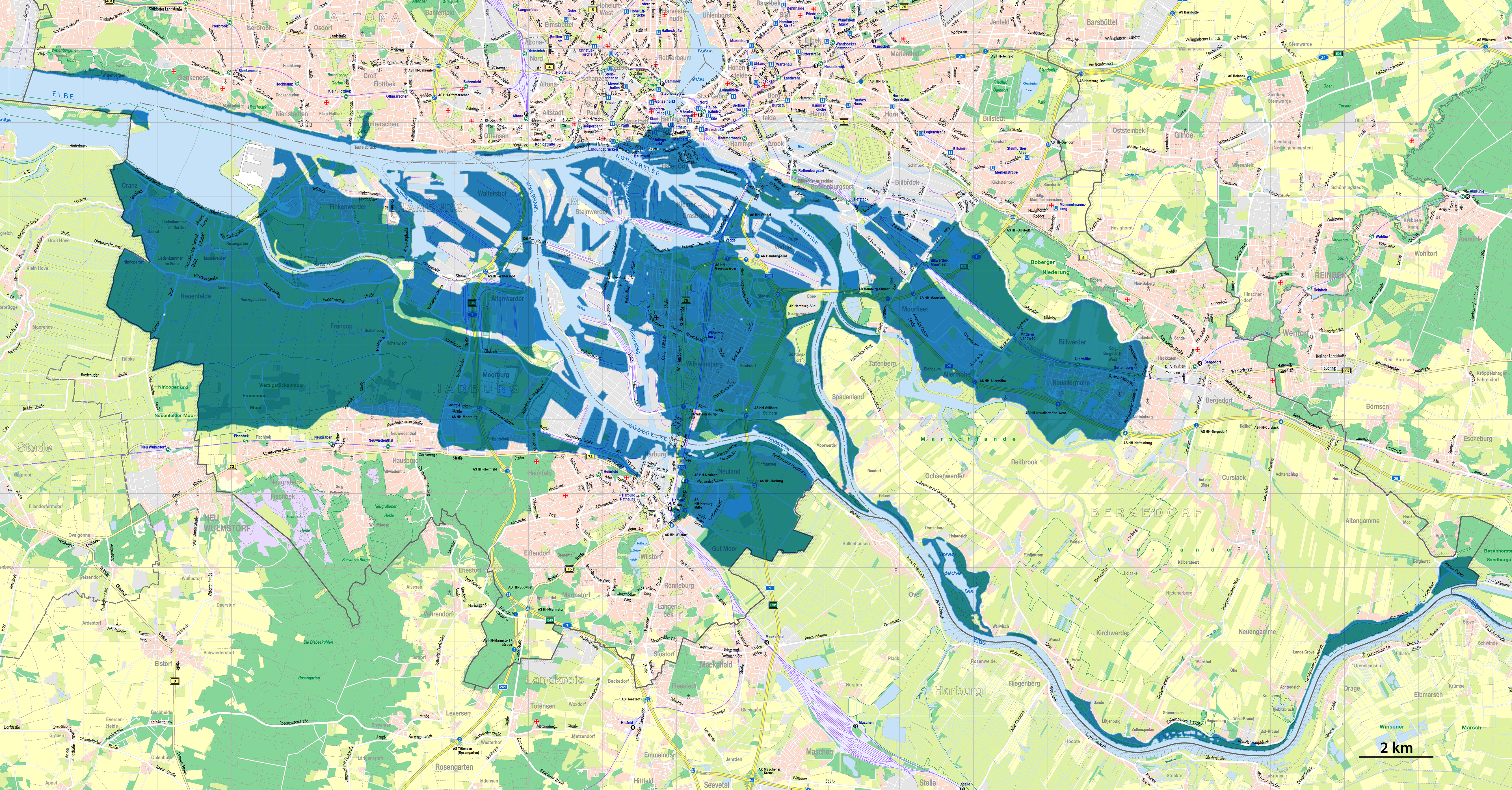
The North Sea flood of 1962 was a natural disaster affecting mainly the coastal regions of West Germany and in particular the city of Hamburg in the night from 16 February to 17 February 1962. In total, the homes of about 60,000 people were destroyed, and the death toll amounted to 315 in Hamburg. The extratropical cyclone responsible for the flooding had previously crossed the United Kingdom as the Great Sheffield Gale, devastating the city of Sheffield and killing nine people. Causes The flood was caused by the ''Vincinette'' low-pressure system, better known as the Great Sheffield Gale, approaching the German Bight from the southern Polar Sea. A European windstorm with peak wind speeds of 200 km/h pushed water into the German Bight, leading to a water surge the dykes could not withstand. Breaches along the coast and the rivers Elbe and Weser led to widespread flooding of huge areas. In Hamburg, on the river Elbe, but a full 100 km away from the coast, the ... [...More Info...] [...Related Items...] OR: [Wikipedia] [Google] [Baidu] |
Tide
Tides are the rise and fall of sea levels caused by the combined effects of the gravitational forces exerted by the Moon (and to a much lesser extent, the Sun) and are also caused by the Earth and Moon orbiting one another. Tide tables can be used for any given locale to find the predicted times and amplitude (or "tidal range"). The predictions are influenced by many factors including the alignment of the Sun and Moon, the phase and amplitude of the tide (pattern of tides in the deep ocean), the amphidromic systems of the oceans, and the shape of the coastline and near-shore bathymetry (see '' Timing''). They are however only predictions, the actual time and height of the tide is affected by wind and atmospheric pressure. Many shorelines experience semi-diurnal tides—two nearly equal high and low tides each day. Other locations have a diurnal tide—one high and low tide each day. A "mixed tide"—two uneven magnitude tides a day—is a third regular category. Tides va ... [...More Info...] [...Related Items...] OR: [Wikipedia] [Google] [Baidu] |
Weir
A weir or low head dam is a barrier across the width of a river that alters the flow characteristics of water and usually results in a change in the height of the river level. Weirs are also used to control the flow of water for outlets of lakes, ponds, and reservoirs. There are many weir designs, but commonly water flows freely over the top of the weir crest before cascading down to a lower level. Etymology There is no single definition as to what constitutes a weir and one English dictionary simply defines a weir as a small dam, likely originating from Middle English ''were'', Old English ''wer'', derivative of root of ''werian,'' meaning "to defend, dam". Function Commonly, weirs are used to prevent flooding, measure water discharge, and help render rivers more navigable by boat. In some locations, the terms dam and weir are synonymous, but normally there is a clear distinction made between the structures. Usually, a dam is designed specifically to impound water beh ... [...More Info...] [...Related Items...] OR: [Wikipedia] [Google] [Baidu] |
Unterelbe
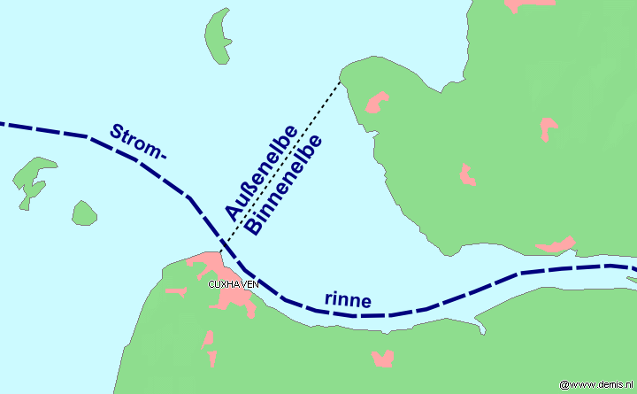
The Unterelbe or, in English usually the Lower Elbe, refers to the lower reaches of the river Elbe in Germany influenced by the tides. It starts at kilometre 586, at the sluice of Geesthacht, where the Elbe forms the border between Lower Saxony and Schleswig-Holstein. It continues downstream, then forming the border between Lower Saxony and Hamburg, before fully entering Hamburg territory. In Hamburg the Unterelbe forms two anabranches, Norderelbe and Süderelbe, the latter now partially a cut-off meander. Where Norderelbe and Süderelbe used to reunite, at kilometre 634 there is a bay called the . This marks the beginning of the section of the Unterelbe which called the Niederelbe. After leaving Hamburg it forms the border between Lower Saxony and Schleswig-Holstein, again. The end it defined by the Kugelbake in Cuxhaven at kilometre 727.73. It continues further into the Wadden Sea as the Außenelbe, where it passes the Hamburg islands Scharhörn and Nigehörn. See also *L ... [...More Info...] [...Related Items...] OR: [Wikipedia] [Google] [Baidu] |


