|
Schafalpenköpfe
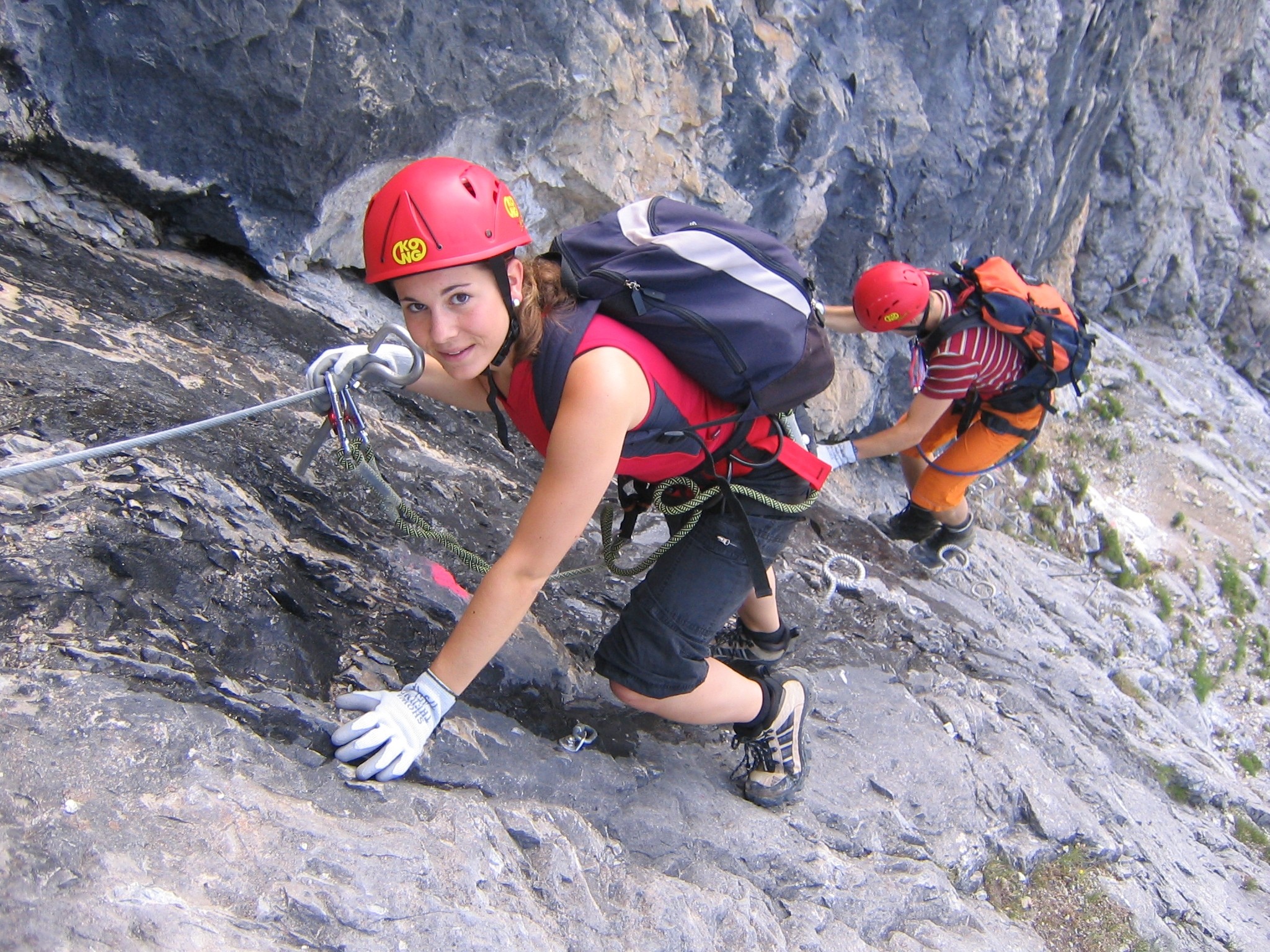
The Schafalpenköpfe are a small mountain formation, consisting of three mountain, peaks, the First Schafalpenkopf, First (2,272 m), Second Schafalpenkopf, Second (2,302 m) and Third Schafalpenkopf (2,320 m). A 2.4-kilometre-long klettersteig of medium difficulty (grade C), the Mindelheimer Klettersteig, runs over them. Origin of the name The naming of the mountains as ''Die Wilden'', "the Wild Ones" probably comes from the valley of Kleinwalsertal to the north, because they do not appear to be of agricultural value from that side. They were first mentioned in 1783 as the ''Wilden Köpf'' in Blasius Hueber's Vorarlberg map. The name of "Schafalpenköpfe" comes from the south and refers to the rocky summits (''Felsköpfe'') above the alpine sheep pastures (''Schäfalpen'') of the Taufersbergalpe, an alpine meadow. The name first appears as ''Schäfalpenkopf'' and ''Schäfalpenköpfl'' in 1819 in an old survey sheet of the Bavarian State Office for Survey and Geoin ... [...More Info...] [...Related Items...] OR: [Wikipedia] [Google] [Baidu] |
First Schafalpenkopf
The First Schafalpenkopf () or Southwestern Schafalpenkopf (''Südwestlicher Schafalpenkopf'') is a 2,272-metre-high mountain in the Allgäu Alps. It is part of the Schafalpenköpfe and the Mindelheim Klettersteig. Location and surrounding area The border between Germany and Austria runs over the summit of the First Schafalpenkopf, simultaneously dividing the states of Bavaria and Vorarlberg. On the Bavarian side it belongs to the administrative areas of the county of Landkreis Oberallgäu, Oberallgäu and the market town of Oberstdorf, on Austria soil to the district of Bezirk Bregenz, Bregenz and the parish of Mittelberg (Vorarlberg), Mittelberg. To the northeast the Second Schafalpenkopf (2,302 m) follows the First, the two being separated by a 2,170-metre-high arête. It is the reference point for the First Schafalpenkopf's topographic prominence of 102 metres. Its topographic isolation, isolation is 500 metres, reaching to the Second Schafalpenkopf. To the south of the ... [...More Info...] [...Related Items...] OR: [Wikipedia] [Google] [Baidu] |
Schafalpenköpfe Kemptner Kopf
The Schafalpenköpfe are a small mountain formation, consisting of three peaks, the First (2,272 m), Second (2,302 m) and Third Schafalpenkopf (2,320 m). A 2.4-kilometre-long klettersteig of medium difficulty (grade C), the Mindelheimer Klettersteig, runs over them. Origin of the name The naming of the mountains as ''Die Wilden'', "the Wild Ones" probably comes from the valley of Kleinwalsertal to the north, because they do not appear to be of agricultural value from that side. They were first mentioned in 1783 as the ''Wilden Köpf'' in Blasius Hueber's Vorarlberg map. The name of "Schafalpenköpfe" comes from the south and refers to the rocky summits (''Felsköpfe'') above the alpine sheep pastures (''Schäfalpen'') of the Taufersbergalpe, an alpine meadow. The name first appears as ''Schäfalpenkopf'' and ''Schäfalpenköpfl'' in 1819 in an old survey sheet of the Bavarian State Office for Survey and Geoinformation in Munich. An 1844 description of the bord ... [...More Info...] [...Related Items...] OR: [Wikipedia] [Google] [Baidu] |
Second Schafalpenkopf
The Second Schafalpenkopf (), also Middle Schafalpenkopf (''Mittlerer Schafalpenkopf'') is a 2,302-metre-high mountain in the Allgäu Alps. It is part of the Schafalpenköpfe and the Mindelheim Klettersteig. Location and surrounding area The border between Germany and Austria runs over the summit of the Second Schafalpenkopf, simultaneously separating the federal states of Bavaria and Vorarlberg. On the Bavarian side it belongs to the administrative units of the county of Oberallgäu and market town of Oberstdorf, on Austrian soil to the district of Bregenz and the parish of Mittelberg. To the northeast the Second Schafalpenkopf is followed by the Third Schafalpenkopf (2,320 m) from which it is separated by a 2,180-metre-high arête, which is the reference point for the Second Schafalpenkopf's topographic prominence of 122 metres. Its isolation is 600 metres, extending across to the Third Schafalpenkopf. To the south of the Second Schafalpenkopf is the valley of Rappe ... [...More Info...] [...Related Items...] OR: [Wikipedia] [Google] [Baidu] |
Mountain
A mountain is an elevated portion of the Earth's crust, generally with steep sides that show significant exposed bedrock. Although definitions vary, a mountain may differ from a plateau in having a limited summit area, and is usually higher than a hill, typically rising at least above the surrounding land. A few mountains are inselberg, isolated summits, but most occur in mountain ranges. mountain formation, Mountains are formed through tectonic plate, tectonic forces, erosion, or volcanism, which act on time scales of up to tens of millions of years. Once mountain building ceases, mountains are slowly leveled through the action of weathering, through Slump (geology), slumping and other forms of mass wasting, as well as through erosion by rivers and glaciers. High elevations on mountains produce Alpine climate, colder climates than at sea level at similar latitude. These colder climates strongly affect the Montane ecosystems, ecosystems of mountains: different elevations hav ... [...More Info...] [...Related Items...] OR: [Wikipedia] [Google] [Baidu] |
Third Schafalpenkopf
The Third Schafalpenkopf (), Highest Schafalpenkopf (''Höchster Schafalpenkopf'') or Northeastern Schafalpenkopf (''Nordöstlicher Schafalpenkopf'') is a 2,320-metre-high mountain in the Allgäu Alps The Allgäu Alps () are a mountain range in the Northern Limestone Alps, located on the Austria–Germany border, which covers parts of the Germany, German states of Bavaria and Baden-Württemberg and the Austrian states of Tyrol (state), Tyrol an .... It is part of the Mindelheimer Klettersteig. File:Dritter Schafalpenkopf vom Zweiten.JPG, From the southwest with the ''Großer Wanne'' File:Dritter Schafalpenkopf from Fiderepasshütte.JPG, From the Fiderepass Hut File:Mindelheimer Klettersteig Einstieg.JPG, Klettersteig entrance File:Mindelheimer Klettersteig Leiterbruecke.JPG, Ladder bridge at the summit References External links * {{DEFAULTSORT:Schafalpenkopf, Third Two-thousanders of Austria Mountains of the Alps Mountains of Bavaria Mountains of Tyrol (feder ... [...More Info...] [...Related Items...] OR: [Wikipedia] [Google] [Baidu] |
Klettersteig
A via ferrata (Italian for "iron path", plural ''vie ferrate'' or in English ''via ferratas'') is a protected climbing route found in the Alps and certain other Alpine locations. The protection includes steel fixtures such as cables and railings to arrest the effect of any fall, which the climber can either hold onto or clip into using climbing protection. Some via ferratas can also include steel fixtures that provide aid in overcoming the obstacles encountered, including steel ladders and steel steps. Description A via ferrata is a climbing route in the mountains that employs steel cables, rungs, or ladders, fixed to the rock to which the climbers affix a harness with two leashes, which allows the climbers to secure themselves to the metal fixture and limit any fall. The cable and other fixtures, such as iron rungs (stemples), pegs, carved steps, and ladders and bridges, provide both footings and handholds, as well. This allows climbing on otherwise dangerous routes without ... [...More Info...] [...Related Items...] OR: [Wikipedia] [Google] [Baidu] |
Bergverlag Rother
Bergverlag Rother is a German publisher with its headquarters in Oberhaching, Upper Bavaria. Since 1950 the company, that formerly went under the name of ''Bergverlag Rudolf Rother'', had published the Alpine Club Guides in cooperation with the German Alpine Club (DAV), the Austrian Alpine Club (ÖAV) and the South Tyrol Alpine Club. Rother publish a "famous series of English language guides" covering most of the popular walking destinations in the Alps and Europe. History The company was founded on 16 November 1920 in Munich Munich is the capital and most populous city of Bavaria, Germany. As of 30 November 2024, its population was 1,604,384, making it the third-largest city in Germany after Berlin and Hamburg. Munich is the largest city in Germany that is no ... by Rudolf Rother sen., a bookseller and mountaineer, and is one of the oldest and most important specialist Alpine publishers. [...More Info...] [...Related Items...] OR: [Wikipedia] [Google] [Baidu] |
Kleinwalsertal
Kleinwalsertal is a valley in the Austrian province of Vorarlberg and part of the Bregenz district. It includes the municipality of Mittelberg and consists of three villages along the River Breitach. Due to the geographic location in the Allgäu Alps with its alpine terrain, the Kleinwalsertal has no direct traffic connection to the rest of Vorarlberg. It is accessible only via Oberstdorf, Germany, to the north, and thus is an Austrian "practical exclave" or "pene-exclave". Etymology The name of the valley derives from the Walsers who moved there from the Valais () in the 13th century (see also " Großwalsertal"). Geography Natural geography The Kleinwalsertal is a high valley in the Allgäu Alps and is located in the east of Vorarlberg. The Breitach river runs through the entire valley and is fed by a few side streams, which come from the side valleys of the Kleinwalsertal. The Kleinwalsertal is almost completely surrounded by high mountains of the Allgäu Alps, which ... [...More Info...] [...Related Items...] OR: [Wikipedia] [Google] [Baidu] |
Bavarian State Office For Survey And Geoinformation
The Bavarian State Office for Digitizing, Broadband and Survey () or LDBV, until 31 December 2013 Bavarian State Office for Survey and Geoinformation () or LVG, is the name of the new division of the Bavarian Department of Survey, Information and Communication Technology within the Bavarian State Ministry of Finance formed on 1 August 2005 as part of the administrative reform in Bavaria. It was formed by a merge of the Bavarian State Survey Office and the survey departments of the district finance divisions responsible for cadastral survey. The LDBV has its headquarters in Munich, discharging its function as a middle-level authority for the 51 survey offices through the three regional divisions in Munich, Landshut and Schwabach Schwabach () is a German city of about 40,000 inhabitants near Nuremberg in the centre of the region of Franconia in the north of Bavaria. Together with the neighboring cities of Nuremberg, Fürth and Erlangen, Schwabach forms one of the three me ... ... [...More Info...] [...Related Items...] OR: [Wikipedia] [Google] [Baidu] |


