|
San Miguel (volcano)
San Miguel (also known as Volcán Chaparrastique) is a stratovolcano in central-eastern El Salvador, approximately southwest of the city of San Miguel. On January 16, 2002, a minor eruption of steam, gas, and ash occurred from the summit crater, lasting 3 hours but causing no real damage to life or property. Carbon dioxide emissions had been monitored since November 2001, and their steady increase continued to build up until the eruption. Twelve years later, on December 29, 2013, San Miguel erupted at 10:30 local time spewing ash and smoke into the sky, and prompted the evacuation of thousands of people living in a 3 km (1.9 mi) radius around the volcano.San Miguel volcano (El Salvador): new eruption ''Volcano Discovery''. Retrieved 30 December ... [...More Info...] [...Related Items...] OR: [Wikipedia] [Google] [Baidu] |
San Miguel Department (El Salvador)
San Miguel () is a department in the eastern part of El Salvador. The capital is San Miguel. The department is 2,077 km2 in area and has a population of over 678,000. Before the Spanish conquest of El Salvador, the territory that now consists of the departments of San Miguel, La Unión and Morazán was the Lenca kingdom of Chaparrastique (Place of Beautiful Orchids). San Miguel was first known as San Miguel de la Frontera. The city was founded by Luis de Moscoso on May 8, 1530, where it is now Santa Elena. On July 11, 1812, the city was given the title of "Noble y Leal Ciudad" (noble and loyal city). It was made a department on June 12, 1824. It is the location of Ciudad Barrios, the birthplace of Archbishop Óscar Romero. Municipalities # San Miguel Centro # San Miguel Norte # San Miguel Sur Districts # Carolina # Chapeltique # Chinameca # Chirilagua # Ciudad Barrios # Comacarán # El Tránsito # Lolotique # Moncagua # Nueva Guadalupe # Nuevo Edén d ... [...More Info...] [...Related Items...] OR: [Wikipedia] [Google] [Baidu] |
List Of Stratovolcanoes
A list of stratovolcanoes follows below. Africa Cameroon * Mount Manengouba, Eboga stratovolcano * Little Mount Cameroon * Mount Cameroon * Mount Oku Democratic Republic of Congo * Mount Nyiragongo, Goma; designated as a Decade Volcano ** It contains an active lava lake inside its crater which overflowed due to cracks in 2002. * Mount Mikeno * Mount Karisimbi * Mount Bisoke * Mount Sabyinyo * Mount Kahuzi Eritrea * Alid Volcano * Dubbi Volcano * Nabro Volcano Ethiopia * Adwa (volcano), Adwa * Aluto * Borawli, Afar Region * Mount Chilalo * Dabbahu Volcano * Mount Fentale Kenya * Mount Kenya, which contains several volcanic plugs on its peak. * Mount Longonot Rwanda * Mount Bisoke, on the border between Rwanda and the Democratic Republic of the Congo. * Mount Gahinga, on the border between Rwanda and Uganda. * Mount Karisimbi, on the border between Rwanda and the Democratic Republic of the Congo. * Mount Muhabura, on the border between Rwanda and Uganda. * Mount ... [...More Info...] [...Related Items...] OR: [Wikipedia] [Google] [Baidu] |
Active Volcanoes
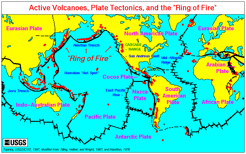
An active volcano is a volcano that is currently erupting, or has the potential to erupt in the future. Conventionally it is applied to any that have erupted during the Holocene (the current geologic epoch that began approximately 11,700 years ago). A volcano that is not currently erupting but could erupt in the future is known as a dormant volcano. Volcanoes that will not erupt again are known as extinct volcanoes. Overview There are 1,350 potentially active volcanoes around the world, 500 of which have erupted in historical time. Many active volcanoes are located along the Pacific Rim, also known as the Pacific Ring of Fire. An estimated 500 million people live near active volcanoes. ''Historical time'' (or recorded history) is another timeframe for ''active''. The span of recorded history differs from region to region. In China and the Mediterranean, it reaches back nearly 3,000 years, but in the Pacific Northwest of the United States and Canada, it reaches back less tha ... [...More Info...] [...Related Items...] OR: [Wikipedia] [Google] [Baidu] |
Stratovolcanoes Of El Salvador
A stratovolcano, also known as a composite volcano, is a typically conical volcano built up by many alternating layers (strata) of hardened lava and tephra. Unlike shield volcanoes, stratovolcanoes are characterized by a steep profile with a summit crater and explosive eruptions. Some have collapsed summit craters called calderas. The lava flowing from stratovolcanoes typically cools and solidifies before spreading far, due to high viscosity. The magma forming this lava is often felsic, having high to intermediate levels of silica (as in rhyolite, dacite, or andesite), with lesser amounts of less viscous mafic magma. Extensive felsic lava flows are uncommon, but can travel as far as 8 km (5 mi). The term ''composite volcano'' is used because strata are usually mixed and uneven instead of neat layers. They are among the most common types of volcanoes; more than 700 stratovolcanoes have erupted lava during the Holocene Epoch (the last 11,700 years), and many older, now ... [...More Info...] [...Related Items...] OR: [Wikipedia] [Google] [Baidu] |
Mountains Of El Salvador
A mountain is an elevated portion of the Earth's crust, generally with steep sides that show significant exposed bedrock. Although definitions vary, a mountain may differ from a plateau in having a limited summit area, and is usually higher than a hill, typically rising at least above the surrounding land. A few mountains are isolated summits, but most occur in mountain ranges. Mountains are formed through tectonic forces, erosion, or volcanism, which act on time scales of up to tens of millions of years. Once mountain building ceases, mountains are slowly leveled through the action of weathering, through slumping and other forms of mass wasting, as well as through erosion by rivers and glaciers. High elevations on mountains produce colder climates than at sea level at similar latitude. These colder climates strongly affect the ecosystems of mountains: different elevations have different plants and animals. Because of the less hospitable terrain and climate, mountains t ... [...More Info...] [...Related Items...] OR: [Wikipedia] [Google] [Baidu] |
Eruption Column
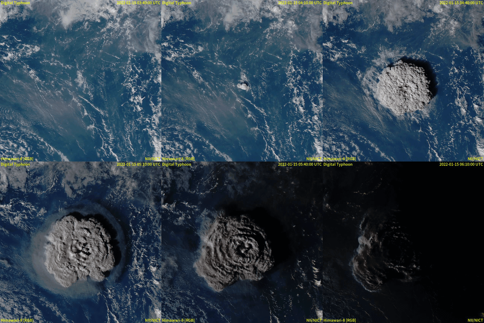
An eruption column or eruption plume is a cloud of super-heated Volcanic ash, ash and tephra suspended in volcanic gas, gases emitted during an explosive eruption, explosive volcanic eruption. The volcanic materials form a vertical column or Plume (fluid dynamics), plume that may rise many kilometers into the air above the vent of the volcano. In the most explosive eruptions, the eruption column may rise over , penetrating the stratosphere. Injection of Particulate, aerosols into the stratosphere by volcanoes is a major cause of short-term Volcanic winter, climate change. A common occurrence in explosive eruptions is ''column collapse'' when the eruption column is or becomes too dense to be lifted high into the sky by air convection, and instead falls down the slopes of the volcano to form pyroclastic flows or pyroclastic surge, surges (although the latter is less dense). On some occasions, if the material is not dense enough to fall, it may create pyrocumulonimbus clouds. Forma ... [...More Info...] [...Related Items...] OR: [Wikipedia] [Google] [Baidu] |
Chinameca (volcano)
Chinameca (also known as El Pacayal) is a stratovolcano in central-eastern El Salvador. It lies north of San Miguel volcano and rises over the town of Chinameca. The volcano is topped by a wide caldera known as Laguna Seca el Pacayal, and a satellite cone on the west side, Cerro el Limbo, rises higher than the caldera rim. Fumaroles can be found on the north side, and it has been the site of a geothermal exploration program. See also *List of volcanoes in El Salvador This is a list of active and extinct volcanoes in El Salvador. Volcanoes See also * Central America Volcanic Arc * List of volcanoes in Guatemala * List of volcanoes in Honduras * List of volcanoes in Nicaragua References {{Cent ... References Mountains of El Salvador Volcanoes of El Salvador Stratovolcanoes of El Salvador Calderas of Central America North American 1000 m summits {{ElSalvador-geo-stub ... [...More Info...] [...Related Items...] OR: [Wikipedia] [Google] [Baidu] |
Usulután (volcano)
Usulután is a stratovolcano in central El Salvador, rising above the coastal plain between the San Vicente and San Miguel volcanoes, and just east of Taburete volcano. The volcano is topped by a wide summit crater which is breached to the east. See also * List of volcanoes in El Salvador * List of stratovolcanoes A list of stratovolcanoes follows below. Africa Cameroon * Mount Manengouba, Eboga stratovolcano * Little Mount Cameroon * Mount Cameroon * Mount Oku Democratic Republic of Congo * Mount Nyiragongo, Goma; designated as a Decade Volcano ... References * Mountains of El Salvador Stratovolcanoes of El Salvador Usulután Department North American 1000 m summits {{ElSalvador-geo-stub ... [...More Info...] [...Related Items...] OR: [Wikipedia] [Google] [Baidu] |
List Of Volcanoes In El Salvador ...
This is a list of active and extinct volcanoes in El Salvador. Volcanoes See also * Central America Volcanic Arc * List of volcanoes in Guatemala * List of volcanoes in Honduras * List of volcanoes in Nicaragua References {{Central American volcanoes El Salvador Volcanoes A volcano is commonly defined as a vent or fissure in the crust of a planetary-mass object, such as Earth, that allows hot lava, volcanic ash, and gases to escape from a magma chamber below the surface. On Earth, volcanoes are most often fo ... [...More Info...] [...Related Items...] OR: [Wikipedia] [Google] [Baidu] |
El Salvador
El Salvador, officially the Republic of El Salvador, is a country in Central America. It is bordered on the northeast by Honduras, on the northwest by Guatemala, and on the south by the Pacific Ocean. El Salvador's capital and largest city is San Salvador. The country's population in 2024 was estimated to be 6 million according to a government census. Among the Mesoamerican nations that historically controlled the region are the Maya peoples, Maya, and then the Cuzcatlan, Cuzcatlecs. Archaeological monuments also suggest an early Olmec presence around the first millennium BC. In the beginning of the 16th century, the Spanish conquest of El Salvador, Spanish Empire conquered the Central American territory, incorporating it into the Viceroyalty of New Spain ruled from Mexico City. However, the Viceroyalty of New Spain had little to no influence in the daily affairs of the isthmus, which was colonized in 1524. In 1609, the area was declared the Captaincy General of Guatemala by the ... [...More Info...] [...Related Items...] OR: [Wikipedia] [Google] [Baidu] |
Seismic Activity
An earthquakealso called a quake, tremor, or tembloris the shaking of the Earth's surface resulting from a sudden release of energy in the lithosphere that creates seismic waves. Earthquakes can range in intensity, from those so weak they cannot be felt, to those violent enough to propel objects and people into the air, damage critical infrastructure, and wreak destruction across entire cities. The seismic activity of an area is the frequency, type, and size of earthquakes experienced over a particular time. The seismicity at a particular location in the Earth is the average rate of seismic energy release per unit volume. In its most general sense, the word ''earthquake'' is used to describe any seismic event that generates seismic waves. Earthquakes can occur naturally or be induced by human activities, such as mining, fracking, and nuclear weapons testing. The initial point of rupture is called the hypocenter or focus, while the ground level directly above it is the ... [...More Info...] [...Related Items...] OR: [Wikipedia] [Google] [Baidu] |
Greenhouse Gas Emissions
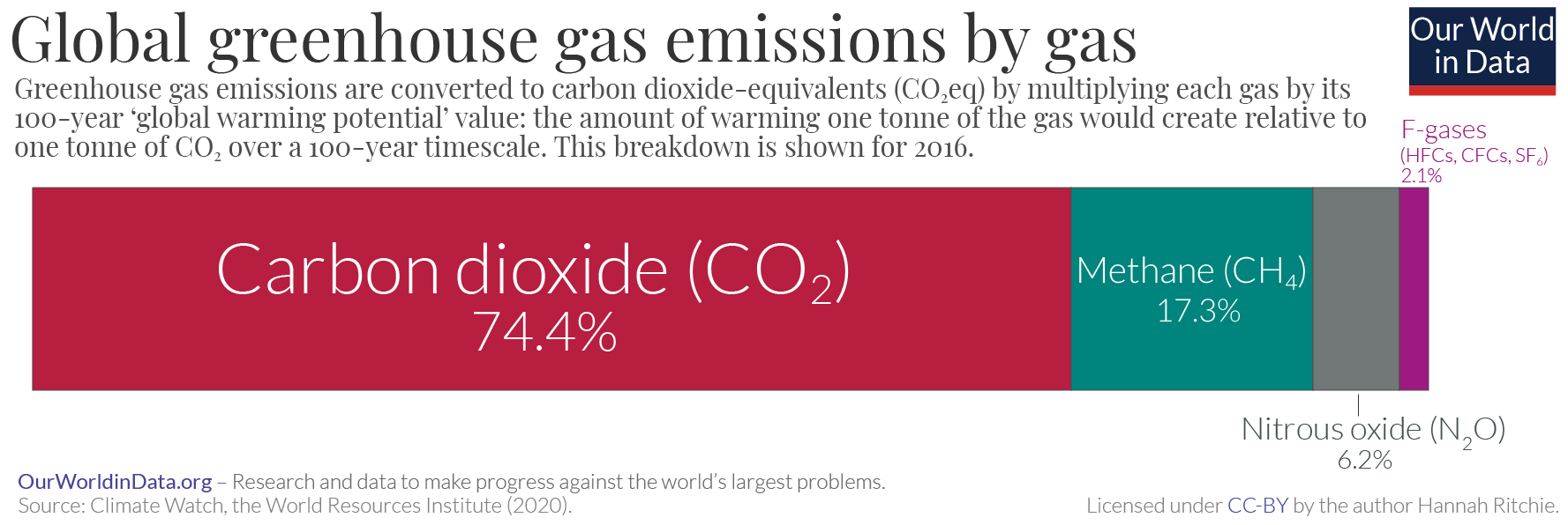
Greenhouse gas (GHG) emissions from human activities intensify the greenhouse effect. This contributes to climate change. Carbon dioxide (), from burning fossil fuels such as coal, petroleum, oil, and natural gas, is the main cause of climate change. The top contributors to greenhouse gas emissions, largest annual emissions are from China followed by the United States. The United States has List of countries by greenhouse gas emissions per capita, higher emissions per capita. The main producers fueling the emissions globally are Big Oil, large oil and gas companies. Emissions from human activities have increased Carbon dioxide in Earth's atmosphere, atmospheric carbon dioxide by about 50% over pre-industrial levels. The growing levels of emissions have varied, but have been consistent among all greenhouse gases. Emissions in the 2010s averaged 56 billion tons a year, higher than any decade before. Total cumulative emissions from 1870 to 2022 were 703 (2575 ), of which 484±20 (177 ... [...More Info...] [...Related Items...] OR: [Wikipedia] [Google] [Baidu] |


