|
Saladillo Stream
The Saladillo Stream (Spanish, Arroyo Saladillo or Río Saladillo) is a small tributary of the Paraná River, that discharges into it between the cities of Rosario and Villa Gobernador Gálvez, in the . It serves as the political border between these two towns of the Greater Rosario area, and is one of the two important affluents of the Paraná in the area, together with the Ludueña Stream in the north. Although in Spanish the Saladillo is called an ''arroyo'', it is not an arroyo in the English sense of a dry or intermittent stream. The Spanish word ''arroyo'' means "stream" or "brook", but the Saladillo is a sizable river with a drainage basin encompassing . Río Saladillo is a variant name in Spanish. Its water services an important area in the southern part of Santa Fe province—both economically for agriculture, and demographically, since its last few kilometres flow through inside a densely populated area (Rosario has over a million residents). The port of Villa Goberna ... [...More Info...] [...Related Items...] OR: [Wikipedia] [Google] [Baidu] |
Arroyo Saladillo
Arroyo often refers to: * Arroyo (watercourse), an intermittently dry creek Arroyo may also refer to: Places United States * Arroyo, Pennsylvania * Arroyo, Puerto Rico, a municipality * Arroyo, West Virginia Spain * Arroyo (Santillana del Mar), a town Other * Arroyo (surname) * Restaurante Arroyo in Mexico City, the world's largest Mexican restaurant * Arroyo, a fictional village in the computer game ''Fallout 2'' * USS ''Arroyo'' (SP-197), a United States Navy patrol boat in commission from 1917 to 1918 * "Arroyo", a song by band SWA See also * Aroya (other) Aroya may refer to: * Årøya, an island of Finnmark, Norway * Arøya, a group of islands of Telemark, Norway * Aroya, Colorado, a small, rural, unincorporated community in Cheyenne County, Colorado Cheyenne County is a county located in the U ... * Arroyo High School (other) * * {{disambiguation, geo ... [...More Info...] [...Related Items...] OR: [Wikipedia] [Google] [Baidu] |
Pollutant
A pollutant or novel entity is a substance or energy introduced into the environment that has undesired effect, or adversely affects the usefulness of a resource. These can be both naturally forming (i.e. minerals or extracted compounds like oil) or anthropogenic in origin (i.e. manufactured materials or byproducts). Pollutants result in environmental pollution or become of public health concern when they reach a concentration high enough to have significant negative impacts. A pollutant may cause long- or short-term damage by changing the growth rate of plant or animal species, or by interfering with resources used by humans, human health or wellbeing, or property values. Some pollutants are biodegradable and therefore will not persist in the environment in a long term. However, the degradation products of some pollutants are themselves pollutants such as DDE and DDD produced from the degradation of DDT. Pollution has widespread negative impact on the environment. Wh ... [...More Info...] [...Related Items...] OR: [Wikipedia] [Google] [Baidu] |
Rivers Of Argentina
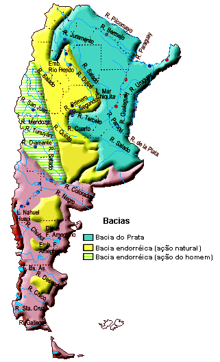
This is a list of rivers of Argentina. Longest Rivers By drainage basin This list is arranged by drainage basin, with respective tributaries indented under each larger stream's name. Rivers in the table above are in bold. La Plata Basin * Río de la Plata ** Uruguay River *** Gualeguaychú River *** Mocoretá River *** Miriñay River *** Aguapey River *** Pepiri-Guazu River ** Paraná River *** Arrecifes River *** Gualeguay River *** Nogoyá River *** Arroyo del Medio *** Saladillo Stream *** Ludueña Stream *** Carcarañá River **** Tercero River (Calamuchita River) **** Cuarto River (Saladillo River, Chocancharava River) *** Salado River (Argentina), Salado River (Salado del Norte, Juramento River, Pasaje River, Calchaquí River) **** Horcones River ***** Urueña River **** Arenales River **** Rosario River (Argentina), Rosario River **** Guasamayo River *** San Javier River (Santa Fe), San Javier River *** Feliciano River *** Guayquiraró River *** Corriente River *** Para ... [...More Info...] [...Related Items...] OR: [Wikipedia] [Google] [Baidu] |
Rosario, Santa Fe
Rosario () is the largest city in the central provinces of Argentina, Argentine province of Santa Fe Province, Santa Fe. The city, located northwest of Buenos Aires on the west bank of the Paraná River, is the third-most populous city in the country after Buenos Aires and Cordoba. With a growing and important metropolitan area, Greater Rosario has an estimated population of 1,750,000 . One of its main attractions includes the neoclassical architecture, neoclassical, Art Nouveau, and Art Deco architecture that has been preserved in hundreds of residences, houses and public buildings. The city is also famous for being the birthplace of the Argentine footballer Lionel Messi. Rosario is the head city of the Rosario Department and is located at the heart of the major industrial corridor in Argentina. The city is a major rail transport, railroad terminal and the shipping center for north-eastern Argentina. Ships reach the city via the Paraná River, which allows the existence of a ... [...More Info...] [...Related Items...] OR: [Wikipedia] [Google] [Baidu] |
Google Maps
Google Maps is a web mapping platform and consumer application offered by Google. It offers satellite imagery, aerial photography, street maps, 360° interactive panorama, interactive panoramic views of streets (Google Street View, Street View), real-time traffic conditions, and route planner, route planning for traveling by foot, car, bike, air (in Software release life cycle#Beta, beta) and public transportation. , Google Maps was being used by over one billion people every month around the world. Google Maps began as a C++ desktop program developed by brothers Lars Rasmussen (software developer), Lars and Jens Eilstrup Rasmussen, Jens Rasmussen, Stephen Ma and Noel Gordon in Australia at Where 2 Technologies. In October 2004, the company was acquired by Google, which converted it into a web application. After additional acquisitions of a geospatial data visualization company and a real-time traffic analyzer, Google Maps was launched in February 2005. The service's Front and ... [...More Info...] [...Related Items...] OR: [Wikipedia] [Google] [Baidu] |
GEOnet Names Server
The GEOnet Names Server (GNS), sometimes also referred to in official documentation as Geographic Names Data or geonames in domain and email addresses, is a service that provides access to the United States National Geospatial-Intelligence Agency's (NGA) and the US Board on Geographic Names's (BGN) database of geographic feature names and locations for locations outside the US. The database is the official repository for the US Federal Government on foreign place-name decisions approved by the BGN. Approximately 20,000 of the database's features are updated monthly. Names are not deleted from the database, "except in cases of obvious duplication". The database contains search aids such as spelling variations and non-Roman script spellings in addition to its primary information about location, administrative division, and quality. The accuracy of the database had been criticised. Accuracy A 2008 survey of South Korea toponyms on GNS found that roughly 1% of them were actually Ja ... [...More Info...] [...Related Items...] OR: [Wikipedia] [Google] [Baidu] |
List Of Rivers Of Argentina
This is a list of rivers of Argentina. Longest Rivers By drainage basin This list is arranged by drainage basin, with respective tributaries indented under each larger stream's name. Rivers in the table above are in bold. La Plata Basin * Río de la Plata ** Uruguay River *** Gualeguaychú River *** Mocoretá River *** Miriñay River *** Aguapey River *** Pepiri-Guazu River ** Paraná River *** Arrecifes River *** Gualeguay River *** Nogoyá River *** Arroyo del Medio *** Saladillo Stream *** Ludueña Stream *** Carcarañá River **** Tercero River (Calamuchita River) **** Cuarto River (Saladillo River, Chocancharava River) *** Salado River (Salado del Norte, Juramento River, Pasaje River, Calchaquí River) **** Horcones River ***** Urueña River **** Arenales River **** Rosario River **** Guasamayo River *** San Javier River *** Feliciano River *** Guayquiraró River *** Corriente River *** Paraná Miní River **** Tapenagá River **** Palometa River ... [...More Info...] [...Related Items...] OR: [Wikipedia] [Google] [Baidu] |
Water Pollution
Water pollution (or aquatic pollution) is the contamination of Body of water, water bodies, with a negative impact on their uses. It is usually a result of human activities. Water bodies include lakes, rivers, oceans, aquifers, reservoirs and groundwater. Water pollution results when contaminants mix with these water bodies. Contaminants can come from one of four main sources. These are sewage discharges, industrial activities, agricultural activities, and urban runoff including stormwater. Water pollution may affect either surface water or groundwater pollution, groundwater. This form of pollution can lead to many problems. One is the environmental degradation, degradation of aquatic ecosystems. Another is spreading Waterborne diseases, water-borne diseases when people use polluted water for drinking or irrigation. Water pollution also reduces the ecosystem services such as drinking water provided by the Water resources, water resource. Sources of water pollution are either p ... [...More Info...] [...Related Items...] OR: [Wikipedia] [Google] [Baidu] |
Urban Stream
An urban stream is a formerly natural River, waterway that flows through a Urban area, heavily populated area. Often times, urban streams are low-lying points in the landscape that characterize catchment urbanization. Urban streams are often Water pollution, polluted by urban runoff and combined sewer outflows. Water scarcity makes flow management in the rehabilitation of urban streams problematic. Description Governments may alter the flow or course of an urban stream to prevent localized flooding by river engineering: lining stream beds with concrete or other hardscape materials, diverting the stream into culverts and storm sewers, or other means. Some urban streams, such as the subterranean rivers of London, run completely underground. These modifications have often reduced habitat for fish and other species, caused downstream flooding due to alterations of flood plains, and worsened water quality. Stressors Toxicants, ionic concentrations, nutrient pollution, available nutr ... [...More Info...] [...Related Items...] OR: [Wikipedia] [Google] [Baidu] |
Flood
A flood is an overflow of water (list of non-water floods, or rarely other fluids) that submerges land that is usually dry. In the sense of "flowing water", the word may also be applied to the inflow of the tide. Floods are of significant concern in agriculture, civil engineering and public health. Environmental issues, Human changes to the environment often increase the intensity and frequency of flooding. Examples for human changes are land use changes such as deforestation and Wetland conservation, removal of wetlands, changes in waterway course or flood controls such as with levees. Global environmental issues also influence causes of floods, namely climate change which causes an Effects of climate change on the water cycle, intensification of the water cycle and sea level rise. For example, climate change makes Extreme weather, extreme weather events more frequent and stronger. This leads to more intense floods and increased flood risk. Natural types of floods include riv ... [...More Info...] [...Related Items...] OR: [Wikipedia] [Google] [Baidu] |
Riparian Zone
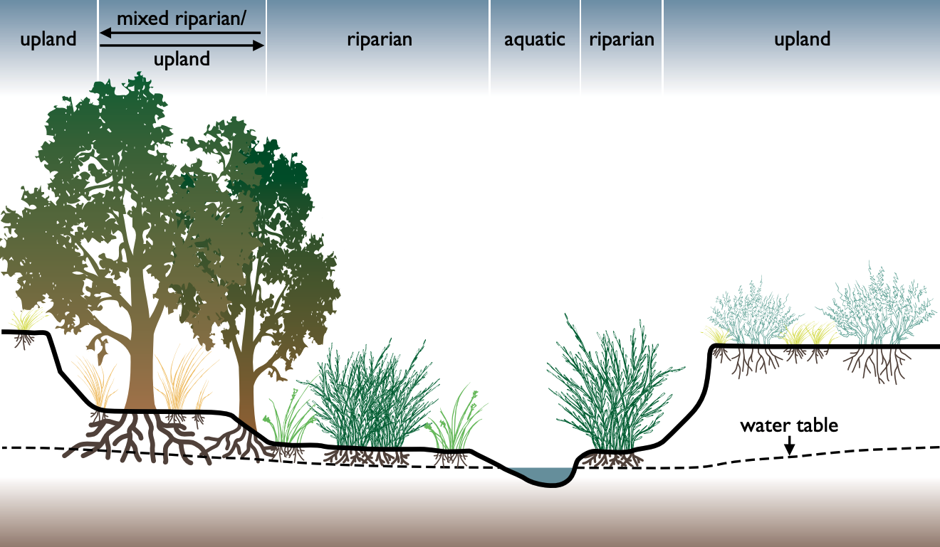
A riparian zone or riparian area is the interface between land and a river or stream. In some regions, the terms riparian woodland, riparian forest, riparian buffer zone, riparian corridor, and riparian strip are used to characterize a riparian zone. The word ''riparian'' is derived from Latin ''wiktionary:ripa, ripa'', meaning "bank (geography), river bank". Riparian is also the proper nomenclature for one of the terrestrial biomes of the Earth. Plant habitats and communities along the river margins and banks are called riparian vegetation, characterized by aquatic plant, hydrophilic plants. Riparian zones are important in ecology, environmental resource management, and civil engineering because of their role in soil conservation, their habitat biodiversity, and the influence they have on terrestrial animal, terrestrial and semiaquatic fauna as well as aquatic ecosystems, including grasslands, woodlands, wetlands, and even non-vegetative areas. Riparian zones may be natural ... [...More Info...] [...Related Items...] OR: [Wikipedia] [Google] [Baidu] |
Erosion
Erosion is the action of surface processes (such as Surface runoff, water flow or wind) that removes soil, Rock (geology), rock, or dissolved material from one location on the Earth's crust#Crust, Earth's crust and then sediment transport, transports it to another location where it is deposit (geology), deposited. Erosion is distinct from weathering which involves no movement. Removal of rock or soil as clastic sediment is referred to as ''physical'' or ''mechanical'' erosion; this contrasts with ''chemical'' erosion, where soil or rock material is removed from an area by Solvation, dissolution. Eroded sediment or solutes may be transported just a few millimetres, or for thousands of kilometres. Agents of erosion include rainfall; bedrock wear in rivers; coastal erosion by the sea and Wind wave, waves; glacier, glacial Plucking (glaciation), plucking, Abrasion (geology), abrasion, and scour; areal flooding; Aeolian processes, wind abrasion; groundwater processes; and Mass wastin ... [...More Info...] [...Related Items...] OR: [Wikipedia] [Google] [Baidu] |


