|
Sacramento County
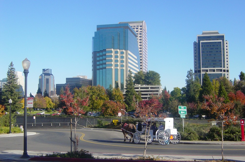
Sacramento County () is a county located in the U.S. state of California. As of the 2020 United States census, the population was 1,585,055. Its county seat is Sacramento, which has been the state capital of California since 1854. Sacramento County is the central county of the Greater Sacramento metropolitan area. The county covers about in the northern portion of the Central Valley, on into Gold Country. Sacramento County extends from the low delta lands between the Sacramento River and San Joaquin River, including Suisun Bay, north to about beyond the State Capitol and east into the foothills of the Sierra Nevada Mountains. The southernmost portion of Sacramento County has direct access to San Francisco Bay. Since 2010, statewide droughts in California have further strained Sacramento County's water security. History Sacramento County was one of the original counties of California, which were created in 1850 at the time of statehood. The county was named after t ... [...More Info...] [...Related Items...] OR: [Wikipedia] [Google] [Baidu] |
List Of Counties In California
The U.S. state of California is divided into 58 counties. The state was first divided into 27 counties on February 18, 1850. These were further sub-divided to form sixteen additional counties by 1860. Another fourteen counties were formed through further subdivision from 1861 to 1893. The most recent county to form was Imperial County, in 1907. California is home to San Bernardino County, the largest county in the contiguous United States, as well as Los Angeles County, the most populous county in the United States. The counties of California are local arms of the State of California, described by the Supreme Court of California as agents ("the county is merely a political subdivision of state government, exercising only the powers of the state, granted by the state…'") and the property they hold is held on behalf of all the people of the state. As such, the State Legislature may delegate any of the functions of the State to the counties but likewise can reassume any ... [...More Info...] [...Related Items...] OR: [Wikipedia] [Google] [Baidu] |
County Seat
A county seat is an administrative center, seat of government, or capital city of a county or parish (administrative division), civil parish. The term is in use in five countries: Canada, China, Hungary, Romania, and the United States. An equivalent term, shire town, is used in the U.S. state of Vermont and in several other English-speaking jurisdictions. Canada In Canada, the Provinces and territories of Canada, provinces of Ontario, Quebec, New Brunswick, Prince Edward Island, and Nova Scotia have counties as an administrative division of government below the provincial level, and thus county seats. In the provinces of Prince Edward Island, New Brunswick, and Nova Scotia, the term "shire town" is used in place of county seat. China County seats in China are the administrative centers of the counties in the China, People's Republic of China. They have existed since the Warring States period and were set up nationwide by the Qin dynasty. The number of counties in China proper g ... [...More Info...] [...Related Items...] OR: [Wikipedia] [Google] [Baidu] |
United States Census Bureau
The United States Census Bureau, officially the Bureau of the Census, is a principal agency of the Federal statistical system, U.S. federal statistical system, responsible for producing data about the American people and American economy, economy. The U.S. Census Bureau is part of the United States Department of Commerce, U.S. Department of Commerce and its Director of the United States Census Bureau, director is appointed by the president of the United States. Currently, Ron S. Jarmin is the acting director of the U.S. Census Bureau. The Census Bureau's primary mission is conducting the United States census, U.S. census every ten years, which allocates the seats of the United States House of Representatives, U.S. House of Representatives to the U.S. state, states based on their population. The bureau's various censuses and surveys help allocate over $675 billion in federal funds every year and it assists states, local communities, and businesses in making informed decisions. T ... [...More Info...] [...Related Items...] OR: [Wikipedia] [Google] [Baidu] |
County (United States)
In the United States, a county or county equivalent is an Administrative division, administrative subdivision of a U.S. state, state or territories of the United States, territory, typically with defined geographic Border, boundaries and some level of governmental authority. The term "county" is used in 48 states, while Louisiana and Alaska have functionally equivalent subdivisions called List of parishes in Louisiana, parishes and List of boroughs and census areas in Alaska, boroughs, respectively. Counties and other local governments in the United States, local governments exist as a matter of U.S. state law, so the specific governmental powers of counties may vary widely between the states, with many providing some level of services to civil townships, Local government in the United States, municipalities, and Unincorporated area#United States, unincorporated areas. Certain municipalities are List of U.S. municipalities in multiple counties, in multiple counties. Some municip ... [...More Info...] [...Related Items...] OR: [Wikipedia] [Google] [Baidu] |
California's 7th Congressional District
California's 7th congressional district is a List of United States congressional districts, United States congressional district in California. Doris Matsui, a Democratic Party (United States), Democrat, has represented the district since January 2023. Currently, it encompasses southern Sacramento County, California, Sacramento County, part of Yolo County, California, Yolo County, and a tiny portion of Solano County, California, Solano County. It includes all of Sacramento, California, Sacramento south of the American River, including Downtown Sacramento, and its suburbs of West Sacramento, California, West Sacramento, Elk Grove, California, Elk Grove, and Galt, California, Galt. It is a heavily Democratic district. Prior to redistricting in 2021, it was entirely in Sacramento County and included the eastern and southern suburbs of Sacramento. Competitiveness Containing most of the state capital of Sacramento, the 7th is currently a solidly Democratic district with a D+16 rati ... [...More Info...] [...Related Items...] OR: [Wikipedia] [Google] [Baidu] |
California's 6th Congressional District
California's 6th congressional district is a congressional district in the U.S. state of California. It is represented by Democratic Party (United States), Democrat Ami Bera. Currently, the 6th district is entirely in Sacramento County, California, Sacramento County and includes the north side of the city of Sacramento, California, Sacramento and its suburbs of Rancho Cordova, California, Rancho Cordova, Citrus Heights, California, Citrus Heights, Rio Linda, California, Rio Linda, Elverta, California, Elverta, Arden-Arcade, California, Arden-Arcade, Antelope, California, Antelope, Foothill Farms, California, Foothill Farms, North Highlands, California, North Highlands, and most of Fair Oaks, California, Fair Oaks. Prior to redistricting by the California Citizens Redistricting Commission of 2021, the district included the entire city of Sacramento, California, Sacramento and some of its suburbs. The district was represented by Democrat Doris Matsui. Recent election results ... [...More Info...] [...Related Items...] OR: [Wikipedia] [Google] [Baidu] |
California's 3rd Congressional District
California's 3rd congressional district is a List of United States congressional districts, U.S. congressional district in California. It includes the northern Sierra Nevada and northeastern suburbs of Sacramento, California, Sacramento, stretching south to Death Valley. It encompasses Alpine County, California, Alpine, Inyo County, California, Inyo, Mono County, California, Mono, Nevada County, California, Nevada, Placer County, California, Placer (where the majority of the district’s population lives), Plumas County, California, Plumas, and Sierra County, California, Sierra counties, as well as parts of El Dorado County, California, El Dorado, Sacramento County, California, Sacramento, and Yuba County, California, Yuba counties. It includes the Sacramento suburbs of Roseville, California, Roseville (the district's largest city), Folsom, California, Folsom, Orangevale, California, Orangevale, Rocklin, California, Rocklin, Auburn, California, Auburn, and Lincoln, California, Li ... [...More Info...] [...Related Items...] OR: [Wikipedia] [Google] [Baidu] |
Area Code 916
Area codes 916 and 279 are telephone area codes in the North American Numbering Plan for Sacramento, the state capital, and most of its suburbs. Area code 916 was one of the first three original area codes established in California in October 1947, originally assigned to the most northern part, but remapped in 1950 to the northeast. Area code splits have reduced the numbering plan area to the greater Sacramento area. Area code 279 began service in an overlay in March 2018 to relieve an exhausted supply of central office codes in 916. History Originally, in 1947, the numbering plan area comprised the far northern portion of the state. In 1950, as part of a realignment of California's area codes, 916 was remapped to the northeastern corner of California, from the Sierra Nevada to the Central Valley. This involved changing Sacramento from area code 415 to 916. In 1958, 916 was reduced in geographic extend in the north, with the creation of new area code 209 for the southern pa ... [...More Info...] [...Related Items...] OR: [Wikipedia] [Google] [Baidu] |
Area Code 209
Area codes 209 and 350 are telephone area codes in the North American Numbering Plan (NANP) for the U.S. state of California. Their service area includes Stockton, Modesto, Turlock, Merced, Winton, Atwater, Livingston, Manteca, Ripon, Tracy, Lodi, Galt, Sonora, Los Banos, San Andreas, Mariposa, and Yosemite, the northern San Joaquin Valley (part of the Central Valley), and the Sierra Foothills. Area code 209 was created in an area code split of area code 916 in 1958. On November 14, 1998, the southern half of this numbering plan area received the assignment of area code 559. On October 24, 2021, 209 was transitioned to ten-digit dialing despite not being part of an overlay complex at that time. The area code had telephone numbers assigned for the central office code 988, which was designated as a nationwide three-digit dialing code for the 988 Suicide & Crisis Lifeline in 2022. This created a conflict for all NPAs with central office code 988 that still permitted ... [...More Info...] [...Related Items...] OR: [Wikipedia] [Google] [Baidu] |
Federal Information Processing Standard
The Federal Information Processing Standards (FIPS) of the United States are a set of publicly announced standards that the National Institute of Standards and Technology (NIST) has developed for use in computer systems of non-military United States government agencies and contractors. FIPS standards establish requirements for ensuring computer security and interoperability, and are intended for cases in which suitable industry standards do not already exist. Many FIPS specifications are modified versions of standards the technical communities use, such as the American National Standards Institute (ANSI), the Institute of Electrical and Electronics Engineers (IEEE), and the International Organization for Standardization (ISO). Specific areas of FIPS standardization The U.S. government has developed various FIPS specifications to standardize a number of topics including: * Codes, e.g., FIPS county codes or codes to indicate weather conditions or emergency indications. In 1994, ... [...More Info...] [...Related Items...] OR: [Wikipedia] [Google] [Baidu] |
Pacific Daylight Time
The Pacific Time Zone (PT) is a time zone encompassing parts of western Canada, the western United States, and western Mexico. Places in this zone observe standard time by subtracting eight hours from Coordinated Universal Time ( UTC−08:00). During daylight saving time, a time offset of UTC−07:00 is used. In the United States and Canada, this time zone is generically called the Pacific Time Zone. Specifically, time in this zone is referred to as Pacific Standard Time (PST) when standard time is being observed (early November to mid-March), and Pacific Daylight Time (PDT) when daylight saving time (mid-March to early November) is being observed. In Mexico, the corresponding time zone is known as the ''Zona Noroeste'' (Northwest Zone) and observes the same daylight saving schedule as the United States and Canada. The largest city in the Pacific Time Zone is Los Angeles, whose metropolitan area is also the largest in the time zone. The zone is two hours ahead of the Hawai ... [...More Info...] [...Related Items...] OR: [Wikipedia] [Google] [Baidu] |


