|
Rutog Town
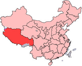
The Rutog Town (), called Rituzhen in Chinese (; ), KNAB place name database. is a town and the seat of Rutog County in the far western . It is also a major military base for China near the disputed border with India allowing it to press its claims militarily. The town was built around in 1999 by the Chinese administration of Tibet on the China National Highway 219.: "Further south the road skirts around the e ... [...More Info...] [...Related Items...] OR: [Wikipedia] [Google] [Baidu] |
People's Republic Of China
China, officially the People's Republic of China (PRC), is a country in East Asia. With population of China, a population exceeding 1.4 billion, it is the list of countries by population (United Nations), second-most populous country after India, representing 17.4% of the world population. China spans the equivalent of five time zones and Borders of China, borders fourteen countries by land across an area of nearly , making it the list of countries and dependencies by area, third-largest country by land area. The country is divided into 33 Province-level divisions of China, province-level divisions: 22 provinces of China, provinces, 5 autonomous regions of China, autonomous regions, 4 direct-administered municipalities of China, municipalities, and 2 semi-autonomous special administrative regions. Beijing is the country's capital, while Shanghai is List of cities in China by population, its most populous city by urban area and largest financial center. Considered one of six ... [...More Info...] [...Related Items...] OR: [Wikipedia] [Google] [Baidu] |
Spanggur Tso
Spanggur Tso, also called Maindong Tso, Mendong Tso, is a saltwater lake in Rutog County in the Tibet Autonomous Region of China, close to the border with Ladakh. India claims a major portion of the lake as its own territory, as part of Ladakh. To the west of the lake lies the Spanggur Gap, a low pass through which the Line of Actual Control runs. To the north is the much larger lake Pangong Tso. Spanggur Tso is at an elevation of 4,305 meters and has an area of 61.6 square kilometres. The lake's average annual temperature is around -4 to -2 °C, and the annual precipitation is 50 to 75 mm. The western portion of the lake is claimed by India. Name The Tibetan name of the lake is Maindong Tso or Mendong Tso (; ),Ngari Prefecture , KNAB Place Name Database, retrieved 27 July 2021. which means "medicine face lake". In Ladakh, it was known ... [...More Info...] [...Related Items...] OR: [Wikipedia] [Google] [Baidu] |
Township-level Divisions Of Tibet
This is a list of Towns of the People's Republic of China, township-level divisions of Tibet Autonomous Region (TAR), People's Republic of China (PRC). After Administrative divisions of the People's Republic of China#Province level, province, Administrative divisions of the People's Republic of China#Prefecture level, prefecture, and Administrative divisions of the People's Republic of China#County level, county-level divisions, township-level divisions constitute the formal fourth-level administrative divisions of the PRC. As of the end of 2014, there are a total of 691 such divisions in TAR, divided into 9 Subdistrict (China), subdistricts, 140 Town (China), towns, 534 Townships of the People's Republic of China, townships, and 8 ethnic townships. Lhasa (prefecture-level city), Lhasa Chengguan District, Lhasa, Chengguan District Subdistricts ( or ; Toinjoichu) * Caigungtang Subdistrict (; ), Chabxi Subdistrict (; ), Garmagoinsar Subdistrict (; ), Gündêling Subdistrict (; ... [...More Info...] [...Related Items...] OR: [Wikipedia] [Google] [Baidu] |
Populated Places In Ngari Prefecture
Population is a set of humans or other organisms in a given region or area. Governments conduct a census to quantify the resident population size within a given jurisdiction. The term is also applied to non-human animals, microorganisms, and plants, and has specific uses within such fields as ecology and genetics. Etymology The word ''population'' is derived from the Late Latin ''populatio'' (a people, a multitude), which itself is derived from the Latin word ''populus'' (a people). Use of the term Social sciences In sociology and population geography, population refers to a group of human beings with some predefined feature in common, such as location, race, ethnicity, nationality, or religion. Ecology In ecology, a population is a group of organisms of the same species which inhabit the same geographical area and are capable of interbreeding. The area of a sexual population is the area where interbreeding is possible between any opposite-sex pair within the area ... [...More Info...] [...Related Items...] OR: [Wikipedia] [Google] [Baidu] |
List Of Towns And Villages In Tibet
An alphabetical list of populated places, including cities, towns, and villages, in the Tibet Autonomous Region of western China. A *Alamdo *Alhar *Arza *Asog B *Baga, Tibet, Baga *Bagar *Baidi, Nagarzê County, Baidi *Baima *Baimai *Baixoi *Bamda *Banag *Banbar *Banggaidoi *Bangkor *Bangru *Bangxing *Baqên Town, Baqên *Bar *Bêba *Bei *Bênqungdo *Bilung *Birba *Biru Town, Biru *Bogkamba *Boindoi *Bolo, Gonjo County, Bolo *Bongba *Boqê *Bumgyê *Bungona’og *Bünsum *Burang Town, Burang *Bushêngcaka C *Caina Township, Caina *Cakaxiang *Camco *Cawarong *Cazê *Cêgnê *Cêngdo *Cêri *Cêrwai *Chabug *Chacang *Chagla *Chagna *Chagyoi *Cha’gyüngoinba *Chalükong *Chamco *Chamda *Chamoling *Changgo *Changlung *Changmar *Charing *Chatang *Chawola *Chêcang *Chênggo *Chepzi *Chibma *Chido *Chigu *Chongkü *Chongsar *Chowa *Chubalung *Chubarong *Chuka *Chumba *Chumbu *Chunduixiang *Co Nyi *Cocholung *Codoi, Tibet, Codoi *Cogo, Tibet, Cogo *Coka, Tibet, Coka *Comai * ... [...More Info...] [...Related Items...] OR: [Wikipedia] [Google] [Baidu] |
Khurnak Plain
The Khurnak Fort () is a ruined fort on the northern shore of Pangong Lake, which spans eastern Ladakh in India and Rutog County in the Tibet region of China. The area of the Khurnak Fort is disputed by India and China, and has been under Chinese administration since 1958. Though the ruined fort itself is not of much significance, it serves as a landmark denoting the middle of Pangong Lake. The fort lies at the western edge of a large plain formed as the alluvial fan of a river called Changlung Lungpa, which falls into Pangong Lake from the north. The plain itself is called ''Ote Plain'' locally, but is now generally called the Khurnak Plain. Geography The Khurnak Fort stands on a large plain called ''Ot'' or ''Ote'' at the centre of Pangong Lake on its northern bank. In recent times, the plain has come to be called the "Khurnak Plain", after the fort. The plain divides Pangong Lake into two halves: to the west is the ''Pangong Tso'' proper and to the east are a string of ... [...More Info...] [...Related Items...] OR: [Wikipedia] [Google] [Baidu] |
Kongka La
The Kongka Pass or Kongka La () is a low mountain pass on the Line of Actual Control between India and China in eastern Ladakh. It lies on a spur of the Karakoram range that intrudes into the Chang Chenmo Valley adjacent to the disputed Aksai Chin region. China claimed the location as its border in a 1956 map, and attacked an Indian patrol party in 1959 killing ten policemen and apprehending ten others. Known as the Kongka Pass incident, the event was a milestone in the escalation of the border dispute between the two countries. Name In the Ladakhi language, Kongka () means a "low pass or ridge, high point or rise of a plateau". In the first reference we have of this pass, it was called "Salmu Kongka" and explained as a "small pass". : Describing the route from Leh to Keriya: "Leaving hangchenmo valleyshortly after the Shahidulla road turns off to the left, it ascends to the plateau by a small pass (the Salmu Kongka); descending again into the valley and crossing the Changche ... [...More Info...] [...Related Items...] OR: [Wikipedia] [Google] [Baidu] |
Tsamda County
13-06-2025 Zanda County or Tsamda County (, zh, s=札达县) is a county in the Ngari Prefecture to the extreme west of the Tibet Autonomous Region of China. Its seat of power is at Tholing, the former capital of the Guge kingdom. Zanda is said to mean “a place where there is grass downstream”, an allusion to the grassy river bed of the Sutlej river that flows through the county. Ancient Zanda horse ('' Hipparion zandaense'') skeletons have been found in Zanda County's Sutlej basin. horsetalk.co.nz, 25 April 2012. Zanda County is bounded by India's sta ... [...More Info...] [...Related Items...] OR: [Wikipedia] [Google] [Baidu] |
Demchok, Ngari Prefecture
Demchok (), KNAB Place Name Database, retrieved 27 July 2021. is a Chinese-administered village in the Zhaxigang Township, Ngari Prefecture in the Tibet Autonomous Region of China. India disputes the status and claims it as part of the Demchok sector that it regards as part of Ladakh. Geography Demchok is located on the west bank of the Indus, roughly 30 k ...[...More Info...] [...Related Items...] OR: [Wikipedia] [Google] [Baidu] |
Spanggur Lake
Spanggur Tso, also called Maindong Tso, Mendong Tso, is a saltwater lake in Rutog County in the Tibet Autonomous Region of China, close to the border with Ladakh. India claims a major portion of the lake as its own territory, as part of Ladakh. To the west of the lake lies the Spanggur Gap, a low pass through which the Line of Actual Control runs. To the north is the much larger lake Pangong Tso. Spanggur Tso is at an elevation of 4,305 meters and has an area of 61.6 square kilometres. The lake's average annual temperature is around -4 to -2 °C, and the annual precipitation is 50 to 75 mm. The western portion of the lake is claimed by India. Name The Tibetan name of the lake is Maindong Tso or Mendong Tso (; ),Ngari Prefecture , KNAB Place Name Database, retrieved 27 July 2021. which means "medicine face lake". In Ladakh, it was know ... [...More Info...] [...Related Items...] OR: [Wikipedia] [Google] [Baidu] |
Lonely Planet
Lonely Planet is a travel guide book publisher. Founded in Australia in 1973, the company has printed over 150 million books. History 20th century Lonely Planet was founded by married couple Maureen Wheeler, Maureen and Tony Wheeler. In 1972, they embarked on an overland trip through Europe and Asia to Australia following the route of the Oxford and Cambridge Far Eastern Expedition. The company name originates from the Mondegreen, misheard "lovely planet" in a song written by Matthew Moore. Lonely Planet's first book, ''Across Asia on the Cheap'', had 94 pages; it was written by the couple in their home. The original 1973 print run consisted of stapled booklets with pale blue cardboard covers. Wheeler returned to Asia to write ''Across Asia on the Cheap: A Complete Guide to Making the Overland Trip'', published in 1975. The Lonely Planet guide book series initially expanded to cover other countries in Asia, with the India guide book in 1981, and expanded to the rest of th ... [...More Info...] [...Related Items...] OR: [Wikipedia] [Google] [Baidu] |
Kashgar
Kashgar () or Kashi ( zh, c=喀什) is a city in the Tarim Basin region of southern Xinjiang, China. It is one of the westernmost cities of China, located near the country's border with Kyrgyzstan and Tajikistan. For over 2,000 years, Kashgar was a strategically important oasis on the Silk Road between China, the Middle East, and Europe. It is one of the oldest continuously inhabited cities in the world and has a population of 711,300 people (). Kashgar's urban area covers , although its administrative area extends over . At the convergence point of widely varying cultures and empires, Kashgar has been under the rule of the Chinese, Turkic, Mongol and Tibetan empires. The city has also been the site of a number of battles between various groups of people on the steppes. Now administered as a county-level city, Kashgar is the administrative centre of Kashgar Prefecture, which has an area of and a population of approximately 4 million . Kashgar was declared a Special Economic ... [...More Info...] [...Related Items...] OR: [Wikipedia] [Google] [Baidu] |


