|
Route Nationale 25
The Route nationale 25 is a motorway in northern France. It connects the towns of Amiens and Arras and is approximately 68 km long. Route Until recently, the road used to begin at a junction with the N1 in the centre of Amiens at the Esplanade Édouard Branly. The road followed Rue du Marechal de Lattre de Tassigny to the north. The new road now starts at a junction with the A29 autoroute and forms the north east section of the town's by-pass. The routes re-converge at junction 38 with the RN 25 heading north and the by-pass becoming the RN 1. The road passes Villers-Bocage passing through open countryside. After Beauval the road drops into the Authie valley and the town of Doullens. The road turns east thereafter and passes several British War Cemeteries. The road passes Beaumetz-lès-Loges before reaching the outskirts of Arras. The new road becomes the towns north west by-pass ending at a junction with the RN 17. The old road is now numbered the RD 265 and n ... [...More Info...] [...Related Items...] OR: [Wikipedia] [Google] [Baidu] |
Motorway
A controlled-access highway is a type of highway that has been designed for high-speed vehicular traffic, with all traffic flow—ingress and egress—regulated. Common English terms are freeway, motorway, and expressway. Other similar terms include ''wikt:throughway, throughway'' or ''thruway'' and ''parkway''. Some of these may be limited-access highways, although this term can also refer to a class of highways with somewhat less isolation from other traffic. In countries following the Vienna Convention on Road Signs and Signals, Vienna convention, the motorway qualification implies that walking and parking are forbidden. A fully controlled-access highway provides an unhindered flow of traffic, with no traffic signals, Intersection (road), intersections or frontage, property access. They are free of any at-grade intersection, at-grade crossings with other roads, railways, or pedestrian paths, which are instead carried by overpasses and underpasses. Entrances and exits to t ... [...More Info...] [...Related Items...] OR: [Wikipedia] [Google] [Baidu] |
Route Nationale 17
The Route nationale 17, or RN17, is a trunk road ( nationale) in France connecting Paris to the border with Belgium. Reclassification The majority of the route runs close to the A1 autoroute. As a result, north of Senlis the road has been downgraded and re-classified as the RD1017 and RD917. There is a small section of the RN17 remaining between Arras and Lille. Route Paris-Senlis-Arras-Lens-Lille-''Belgium'' Paris to Senlis (0 km – 31 km) The road starts north of Paris as a branch of the RN2, opposite the Airport Paris-Le Bourget, and heads north east as the Av du Mai 1985 and then Route de Flandre. The road skirts the western edge of the Charles de Gaulle Airport, crosses the RD104 and then through open countryside. After the village of Survillers the road enters the ''Parc Naturel Régional de Oise Pays de France''. The road now passes through the ''Forêt du Chantilly'' before reaching the Cathedral City of Senlis. Senlis to Arras (31 km to 162 km) At Senlis there are ... [...More Info...] [...Related Items...] OR: [Wikipedia] [Google] [Baidu] |
Carvin
Carvin () is a Communes of France, commune in the Pas-de-Calais Departments of France, department in the Hauts-de-France region of France about northeast of Lens, Pas-de-Calais, Lens. History During World War I, from October 1914 to October 1918, Carvin was occupied by the Germans. Over 6,000 soldiers are buried in one of the largest German cemeteries in the Nord-Pas-de-Calais region. Carvin was awarded the Croix de guerre 1914–1918 (France), Croix de Guerre on 28 September 1920. In May 1940, during the Germany, German invasion of France, a battle in Carvin's town centre allowed the bulk of British and French troops to escape to the Dunkirk evacuation. Once the allies had gone, the troops of the Wehrmacht arrested and murdered many miners at Arras. In 1947, Carvin lost nearly a third of its territory with the separation of the commune of Libercourt. Population Twin towns Carvin is Twin towns and sister cities, twinned with: * Kłodzko, Poland * Carvico, Italy See al ... [...More Info...] [...Related Items...] OR: [Wikipedia] [Google] [Baidu] |
Abbeville
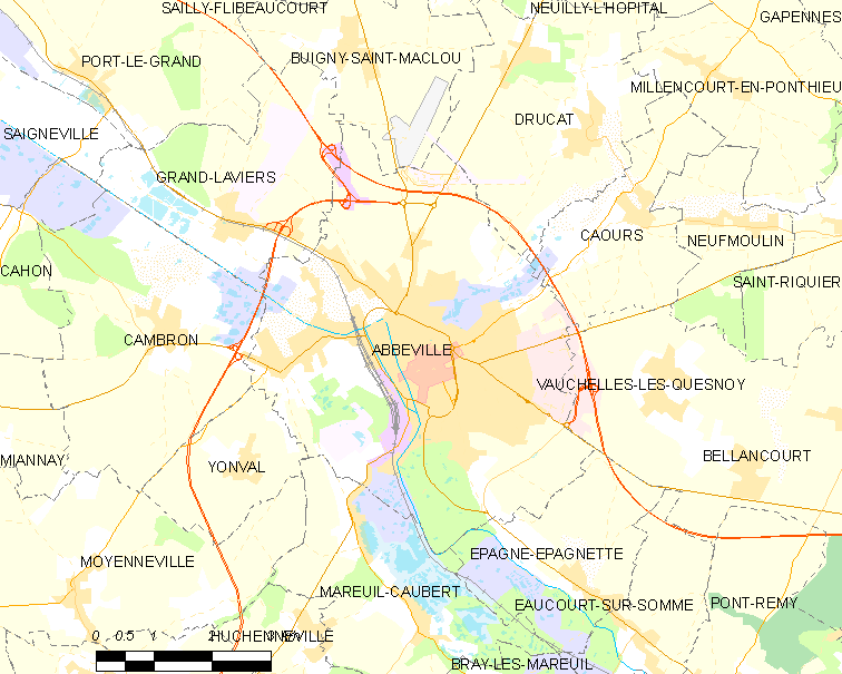
Abbeville (; ; ) is a commune in the Somme department and in Hauts-de-France region in northern France. It is the of one of the arrondissements of Somme. Located on the river Somme, it was the capital of Ponthieu. Geography Location Abbeville is located on the river Somme, from its modern mouth in the English Channel. The majority of the town is located on the east bank of the Somme, as well as on an island. It is located at the head of the Abbeville Canal, and is northwest of Amiens and approximately from Paris. It is also as the crow flies from the and the English Channel. In the medieval period, it was the lowest crossing point on the Somme and it was nearby that Edward III's army crossed shortly before the Battle of Crécy in 1346. Just halfway between Rouen and Lille, it is the historical capital of the County of Ponthieu and maritime Picardy. Quarters, hamlets and localities *Émonville Park takes its name from one of its owners Arthur Foulc d'Émonvil ... [...More Info...] [...Related Items...] OR: [Wikipedia] [Google] [Baidu] |
Eu, Seine-Maritime
Eu () is a Communes of France, commune in the Seine-Maritime Departements of France, department in the Normandy (administrative region), Normandy Regions of France, region in northern France. Eu is located near the coast in the eastern part of the department, near the border with Picardy. Its inhabitants are known in French as the ''Eudois''. Geography Eu is situated at the junction of the RD 1015, the Route nationale 25, RD 925, the RD 940 and the RD 1314 roads, in the steep-sided valley of the river Bresle (river), Bresle, whose mouth is away to the north-west in Le Tréport. Eu station has rail connections to Beauvais and Le Tréport. Etymology The name of the commune is related to that of the river on which it stands. Before being called the ''Bresle'', this small river was known in the Middle Ages under the name of ''Ou'', which then became ''Eu''. History The County of Eu was created in 996 by Duke Richard I of Normandy for his illegitimate son Geoffrey, Count of Brio ... [...More Info...] [...Related Items...] OR: [Wikipedia] [Google] [Baidu] |
Dieppe, Seine-Maritime
Dieppe (; ; or Old Norse ) is a coastal Communes of France, commune in the Seine-Maritime departments of France, department, Normandy (administrative region), Normandy, northern France. Dieppe is a seaport on the English Channel at the mouth of the river Arques (river), Arques. A regular ferry service runs to Newhaven, East Sussex, Newhaven in England. Famous for its scallops, Dieppe also has a popular Shingle beach, pebbled beach, a 15th-century castle and the churches of James, son of Zebedee, Saint-Jacques and Saint Remigius, Saint-Remi. The mouth of the river Scie (river), Scie lies at Hautot-sur-Mer, directly to the west of Dieppe. The inhabitants of the town of Dieppe are called () and () in French. History First recorded as a small fishing settlement in 1030, Dieppe was an important prize fought over during the Hundred Years' War. It housed Dieppe maps, the most advanced French school of cartography in the 16th century. Two of France's best navigators, Michel le V ... [...More Info...] [...Related Items...] OR: [Wikipedia] [Google] [Baidu] |
Saint-Valery-en-Caux
Saint-Valery-en-Caux (, literally ''Saint-Valery in Pays de Caux, Caux'') is a Communes of France, commune in the Seine-Maritime Departments of France, department in the Normandy (administrative region), Normandy region in northern France. The addition of an acute accent on the "e" (Valéry) is incorrect. Geography The town is located north of Rouen. A small fishing port and light industrial town situated in the Pays de Caux, some west of Dieppe at the junction of the D53, D20, D79 and the D925 roads. Here, huge chalk cliffs rise up from the pebble beach (sandy at low tide) to overlook the English Channel. The Gare de Saint-Valery-en-Caux, SNCF station closed in the 1990s and the only public transport is an infrequent bus service. History The town is said to have been founded by Walric, abbot of Leuconay, Saint Valery in the 7th century. A monastery was built on the site of the present-day town and was known as ‘’’Sanctum Walaricum’’’ in 990 Common Era, CE, acc ... [...More Info...] [...Related Items...] OR: [Wikipedia] [Google] [Baidu] |
Fécamp
Fécamp () is a commune in the northwestern French department of Seine-Maritime. Geography Fécamp is situated in the valley of the river Valmont, at the heart of the Pays de Caux, on the Alabaster Coast. It is around northeast of Le Havre, and around northwest of Rouen. History Origin of the name According to its late medieval founding legend, the trunk of a fig tree (''ficus'') carrying the Precious Blood of Christ collected by Joseph of Arimathea was washed ashore on the riverbank at Fécamp in the 1st century. Immediately, a fountain of holy blood gushed from the site; the relic attracted many medieval pilgrims, enhancing the reputation of the city. The monks' legend justified the artificial etymology of the name to ''Fici-campus'', the camp of the fig tree. Fécamp, however, is mentioned in 875 as ''Fiscannum'' and in 990 as ''Fiscannus'' and as late as 1496 which stem from the Germanic root ''fisc'' (English "fish") with an unknown suffix. It used to be the name ... [...More Info...] [...Related Items...] OR: [Wikipedia] [Google] [Baidu] |
Lille
Lille (, ; ; ; ; ) is a city in the northern part of France, within French Flanders. Positioned along the Deûle river, near France's border with Belgium, it is the capital of the Hauts-de-France Regions of France, region, the Prefectures in France, prefecture of the Nord (French department), Nord Departments of France, department, and the main city of the Métropole Européenne de Lille, European Metropolis of Lille. The city of Lille proper had a population of 236,234 in 2020 within its small municipal territory of , but together with its French suburbs and exurbs the Lille metropolitan area (French part only), which extends over , had a population of 1,515,061 that same year (January 2020 census), the fourth most populated in France after Paris, Lyon, and Marseille. The city of Lille and 94 suburban French municipalities have formed since 2015 the Métropole Européenne de Lille, European Metropolis of Lille, an Indirect election, indirectly elected Métropole, metropolitan ... [...More Info...] [...Related Items...] OR: [Wikipedia] [Google] [Baidu] |
Le Havre
Le Havre is a major port city in the Seine-Maritime department in the Normandy (administrative region), Normandy region of northern France. It is situated on the right bank of the estuary of the Seine, river Seine on the English Channel, Channel southwest of the Pays de Caux, very close to the Prime Meridian (Greenwich), Prime Meridian. Le Havre is the most populous commune of Upper Normandy, although the total population of the greater Le Havre conurbation is smaller than that of Rouen. It is also the second largest subprefecture in France, after only Reims. The name ''Le Havre'' means "the harbour" or "the port". Its inhabitants are known as ''Havrais'' or ''Havraises''. The city and Port of Le Havre, port were founded by Francis I of France, King Francis I in 1517. Economic development in the early modern period was hampered by European wars of religion, religious wars, conflicts with the English, epidemics, and storms. It was from the end of the 18th century that Le Havre st ... [...More Info...] [...Related Items...] OR: [Wikipedia] [Google] [Baidu] |
Beaumetz-lès-Loges
Beaumetz-lès-Loges (; Picard:''Biaumetz-lès-Loges'') is a commune in the Pas-de-Calais department in the Hauts-de-France region in northern France. Geography A farming village located 7 miles (11 km) southwest of Arras at the junction of the N25 with the D7 road. Population Sights * The church of St. Michel, dating from the fifteenth century. * Vestiges of an old castle. * A World War I cemetery. See also *Communes of the Pas-de-Calais department The following is a list of the 887 communes of the Pas-de-Calais department of France. The communes cooperate in the following intercommunalities (as of 2025): References External links The cemetery at Beaumetz [...More Info...] [...Related Items...] OR: [Wikipedia] [Google] [Baidu] |
France
France, officially the French Republic, is a country located primarily in Western Europe. Overseas France, Its overseas regions and territories include French Guiana in South America, Saint Pierre and Miquelon in the Atlantic Ocean#North Atlantic, North Atlantic, the French West Indies, and List of islands of France, many islands in Oceania and the Indian Ocean, giving it Exclusive economic zone of France, one of the largest discontiguous exclusive economic zones in the world. Metropolitan France shares borders with Belgium and Luxembourg to the north; Germany to the northeast; Switzerland to the east; Italy and Monaco to the southeast; Andorra and Spain to the south; and a maritime border with the United Kingdom to the northwest. Its metropolitan area extends from the Rhine to the Atlantic Ocean and from the Mediterranean Sea to the English Channel and the North Sea. Its Regions of France, eighteen integral regions—five of which are overseas—span a combined area of and hav ... [...More Info...] [...Related Items...] OR: [Wikipedia] [Google] [Baidu] |


