|
Rosenberg (Baden)
Rosenberg (Baden) is a Franconian town in the Neckar-Odenwald-Kreis, district of Neckar-Odenwald-Kreis, in Baden-Württemberg, Germany, about 26 km northeast of Mosbach. It belongs to the European metropolitan region of Rhine-Neckar. Geography Location Rosenberg lies in the Muschelkalk hill country of the Bauland region and is one-third forested. The municipal area is drained by the Kirnau river. Municipal divisions The municipality of Rosenberg includes the former municipalities of Bronnacker, Hirschlanden and Sindolsheim. The municipality of Rosenberg within the boundaries of 1970 included the village (formerly a minor town) of Rosenberg, the locality Siedlung Dörrhof, and the houses Gaimühle and Talmühle. The municipality of Rosenberg in 1970 included the deserted villages of Mensingenheim and the demolished Neumühle. The deserted village of Mettelheim is included in the area of the former municipality of Sindolsheim. History 13th to 19th centuries Rosenberg was fi ... [...More Info...] [...Related Items...] OR: [Wikipedia] [Google] [Baidu] |
Franconia
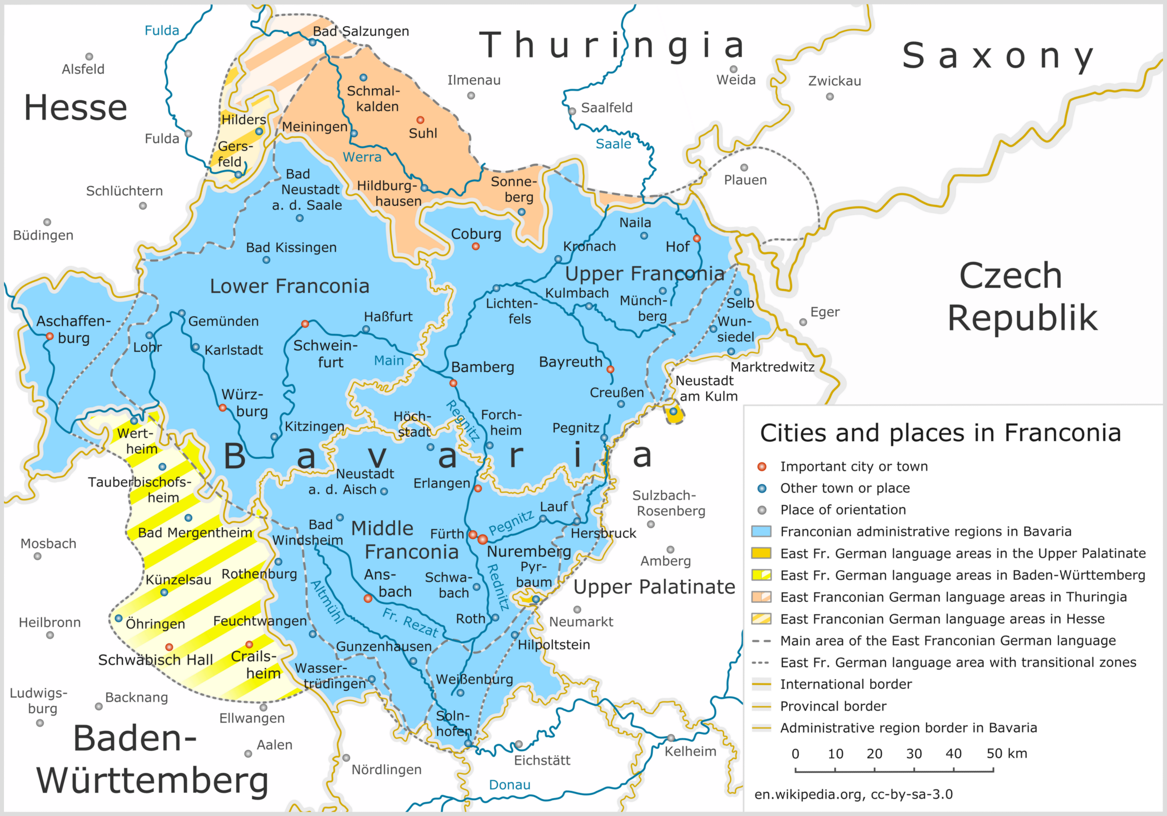
Franconia ( ; ; ) is a geographical region of Germany, characterised by its culture and East Franconian dialect (). Franconia is made up of the three (governmental districts) of Lower Franconia, Lower, Middle Franconia, Middle and Upper Franconia in Bavaria, the adjacent, East Franconian, Franconian-speaking South Thuringia, south of the Thuringian Forest—which constitutes the language boundary between Franconian and Thuringian—and the eastern parts of Heilbronn-Franconia in Baden-Württemberg. Those parts of the Vogtland lying in Saxony (largest city: Plauen) are sometimes regarded as Franconian as well, because the Vogtlandian dialects are mostly East Franconian. The inhabitants of Saxon Vogtland, however, mostly do not consider themselves Franconian. On the other hand, the inhabitants of the Hessian dialect, Hessian-speaking parts of Lower Franconia west of the Spessart (largest city: Aschaffenburg) do consider themselves Franconian, although not speaking the dialect. He ... [...More Info...] [...Related Items...] OR: [Wikipedia] [Google] [Baidu] |
Franconian Railway
{{disambig ...
Franconian may refer to: *anything related to Franconia (German ''Franken''), a historic region in Germany, now part of Bavaria, Thuringia and Baden-Württemberg *East Franconian German, a dialect spoken in Franconia *Franconian languages *Franconian (stage), a stage in North American stratigraphy named for the Franconia Formation, near the town of Franconia in eastern Minnesota *Franconian notation, mensural musical notation as formulated by Franco of Cologne in the 13th century See also * Name of the Franks *Frankish (other) *Franks (other) Frank, FRANK, or Franks may refer to: People * Frank (given name) * Frank (surname) * Franks (surname) * Franks, a Germanic people in late Roman times * Franks, a term in the Muslim world for all western Europeans, particularly during the Crus ... [...More Info...] [...Related Items...] OR: [Wikipedia] [Google] [Baidu] |
Würzburg
Würzburg (; Main-Franconian: ) is, after Nuremberg and Fürth, the Franconia#Towns and cities, third-largest city in Franconia located in the north of Bavaria. Würzburg is the administrative seat of the Regierungsbezirk Lower Franconia. It spans the banks of the Main (river), Main river. Würzburg is situated approximately 110 km west-northwest of Nuremberg and 120 km east-southeast of Frankfurt, Frankfurt am Main. The population as of 2019 is approximately 130,000 residents. Würzburg is famous for its partly rebuilt and reconstructed old town and its Würzburger Residenz, a palace that is a List of World Heritage Sites in Germany, UNESCO World Heritage Site. The regional dialect is East Franconian German. History Early and medieval history A Bronze Age Europe, Bronze Age (Urnfield culture) refuge castle, the Celtic Segodunum, and later a Roman Empire, Roman fort, stood on the hill known as the Leistenberg, the site of the present Fortress Marienberg. The ... [...More Info...] [...Related Items...] OR: [Wikipedia] [Google] [Baidu] |
Heilbronn
Heilbronn () is a List of cities and towns in Germany, city in northern Baden-Württemberg, Germany, surrounded by Heilbronn (district), Heilbronn District. From the late Middle Ages on, it developed into an important trading centre. At the beginning of the 19th century, Heilbronn became one of the centres of early industrialisation in Württemberg. Heilbronn's old town was completely destroyed during the air raid of 4 December 1944 and rebuilt in the 1950s. Today Heilbronn is the economic centre of the Heilbronn-Franconia, Heilbronn-Franken region. Heilbronn is known for its wine industry and is nicknamed ''Käthchenstadt'', after Heinrich von Kleist's ''Das Käthchen von Heilbronn''. Geography Heilbronn is located in the northern corner of the Neckar Sedimentary basin, basin at the bottom of the Wartberg (Heilbronn), Wartberg (308 m). It occupies both banks of the Neckar, and the highest spot inside city limits is the Schweinsberg (mountain), Schweinsberg with a height of 372 ... [...More Info...] [...Related Items...] OR: [Wikipedia] [Google] [Baidu] |
Rathaus Gemeinde Rosenberg
In local government, a city hall, town hall, civic centre (in the UK or Australia), guildhall, or municipal hall (in the Philippines) is the chief administrative building of a city, town, or other municipality. It usually houses the city or town council and at least some other arms of the local government. It also often functions as the office of the mayor (or other executive), if the relevant municipality has such an officer. In large cities, the local government is often administratively expansive, and the city hall may bear more resemblance to a municipal capitol building. By convention, until the middle of the 19th century, a single large open chamber (or "hall") formed an integral part of the building housing the council and such other organs of government as supported it. The hall may be used for council meetings and other significant events. This large chamber, the "town hall" (and its later variant "city hall") became synonymous with the whole building, and, synec ... [...More Info...] [...Related Items...] OR: [Wikipedia] [Google] [Baidu] |
Grand Duchy Of Baden
The Grand Duchy of Baden () was a German polity on the east bank of the Rhine. It originally existed as a sovereign state from 1806 to 1871 and later as part of the German Empire until 1918. The duchy's 12th-century origins were as a Margraviate of Baden, margraviate that eventually split into two, Margraviate of Baden-Durlach, Baden-Durlach and Margraviate of Baden-Baden, Baden-Baden, before being reunified in 1771. The territory grew and assumed its ducal status after the dissolution of the Holy Roman Empire but suffered a Baden Revolution, revolution in 1848, whose demands had been formulated in Offenburg the previous year at a meeting now considered the first-ever democratic program in Germany. With the collapse of the German Empire it became part of the Weimar Republic under the name Republic of Baden. The Grand Duchy of Baden was bordered to the north by the Kingdom of Bavaria and the Grand Duchy of Hesse, to the west by the Rhine, to the south by Switzerland, and to the ... [...More Info...] [...Related Items...] OR: [Wikipedia] [Google] [Baidu] |
Neckar-Odenwald-Kreis
Neckar-Odenwald-Kreis is a ''Landkreis'' (district) in the north of Baden-Württemberg, Germany. Neighboring districts are (from east clockwise) Main-Tauber-Kreis, Hohenlohe-Kreis, Heilbronn, Rhein-Neckar-Kreis, Odenwaldkreis (Hesse) and Landkreis Miltenberg (Bavaria). The district is part of the Rhine-Neckar Metropolitan Region. History The district was created in 1973 by merging the previous districts Buchen and Mosbach. At first it was named ''Odenwaldkreis'', however to avoid confusion with the neighboring district in Hesse with the same name it was renamed in 1974 to be ''Neckar-Odenwald-Kreis''. Geography As the name already suggests the district is located in the Odenwald mountains, with the highest elevation at the Katzenbuckel (626 m) near Waldbrunn in the west of the district. The main river of the district is the Neckar. Coat of arms The district's coat of arms might be described thus: Per pale dexter bendy lozengy argent and azure, sinister gules a wheel spo ... [...More Info...] [...Related Items...] OR: [Wikipedia] [Google] [Baidu] |
Bailiwick Of Franconia
Bad Mergentheim (; Mergentheim until 1926; East Franconian: ''Märchedol'') is a town in the Main-Tauber-Kreis district in the German state of Baden-Württemberg. It has a population of around 23,000. An officially recognized spa town since 1926, Bad Mergentheim is also known as the headquarters of the Teutonic Order from 1526 until 1809. Geography Subdivisions Since administrative reform in the 1970s the following villages have been part of the municipality: Althausen ''(pop. 600)'', Apfelbach ''(350)'', Dainbach ''(370)'', Edelfingen ''(1,400''; birthplace of the American biochemist Julius Adler), Hachtel ''(360)'', Herbsthausen ''(200)'', Löffelstelzen ''(1,000)'', Markelsheim ''(2,000)'', Neunkirchen ''(1,000)'', Rengershausen ''(480)'', Rot ''(260)'', Stuppach ''(680)'', Wachbach ''(1,300)'' History Mergentheim is mentioned in chronicles as early as 1058, as the residence of the family of the counts of Hohenlohe. The brothers Andreas, Heinrich and Friedrich von Hohenlohe ... [...More Info...] [...Related Items...] OR: [Wikipedia] [Google] [Baidu] |


