|
Robert C. Patterson (engineer)
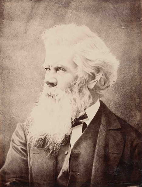
Robert Charles Patterson (21 March 1844 – 21 June 1907) was an Australian engineer, remembered for his work on railways in three colonies, the Australian Overland Telegraph Line (OTL), and civic works in Tasmania, where he served a term in the Tasmanian House of Assembly, House of Assembly. History Patterson was born in Melbourne, son of Mary Jane Patterson, a daughter of George Keys of Dandenong, and James Patterson, a merchant, who died around 1850. Mrs Patterson married again, in 1856, to James Jamieson, of County Tyrone, also her birthplace. He was educated at the St Kilda, Victoria#Education and schools, Collegiate School, St Kilda, where he won the gold medal in two consecutive semesters in 1857 He went on to King's College, London, where he studied engineering and was articled to William Wilson M. Inst, C.E., of Westminster. Wilson was known for his work on the Grosvenor Bridge, Victoria Bridge, the first railway bridge over the Thames. Railways His articles havin ... [...More Info...] [...Related Items...] OR: [Wikipedia] [Google] [Baidu] |
Australian Overland Telegraph Line
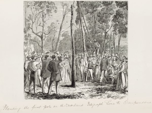
The Australian Overland Telegraph Line was an electrical telegraph system for sending messages the between Darwin, in what is now the Northern Territory of Australia, and Adelaide, the capital of South Australia. Completed in 1872 (with a line to Western Australia added in 1877), it allowed fast communication between Australia and the rest of the world. When it was linked to the Java-to-Darwin submarine telegraph cable several months later, the communication time with Europe dropped from months to hours; Australia was no longer so isolated from the rest of the world. The line was one of the great engineering feats of 19th-century Australia and probably the most significant milestone in the history of telegraphy in Australia. Conception and competition By 1855 speculation had intensified about possible routes for the connection of Australia to the new telegraph cable in Java and thus Europe. Among the routes under consideration were either Ceylon to Albany in Western Austr ... [...More Info...] [...Related Items...] OR: [Wikipedia] [Google] [Baidu] |
Deloraine, Tasmania
Deloraine is a town on the Meander River (Tasmania), Meander River, in the central north of Tasmania, Australia. It is 50 km west of Launceston, Tasmania, Launceston and 52 km south of Devonport, Tasmania, Devonport along the Bass Highway (Tasmania), Bass Highway. It is part of the Meander Valley Council. Deloraine recorded a population of 3,035 in the . Deloraine, like most Tasmanian towns, has a temperate and wet climate. History The region was explored in 1821 by Captain Roland, who was searching for farm land. The land was granted to new settlers, and the town is now a major agricultural centre, with a large number of farms of all types in the area. Deloraine is named after a character from the poem ''The Lay of the Last Minstrel'', written by Sir Walter Scott. Deloraine Post Office opened on 29 October 1836. The town won the State Tidy Towns award in 1992, 1993 and 1995, and the Australian Community of the Year award in 1997. Economy While Deloraine is a predomi ... [...More Info...] [...Related Items...] OR: [Wikipedia] [Google] [Baidu] |
Leader Of The Opposition (Tasmania)
The leader of the opposition in Tasmania is the title of the leader of the largest minority party in the state lower house, the Tasmanian House of Assembly. They act as the public face of the opposition, leads the opposition on the floor of parliament. They thus act as a chief critic of the government and ultimately attempt to portray the opposition as a feasible alternate government. They are also given certain additional rights under parliamentary standing orders, such as extended time limits for speeches. Should the opposition win an election, the leader of the opposition will usually be nominated to become the premier of Tasmania. The position of leader of the opposition was essentially informal throughout the nineteenth century, with formal recognition only being granted in the early twentieth century. As there was no party system until 1909, the loose ideological blocs in parliament tended to change regularly, and few people lasted in the position for more than one or two ... [...More Info...] [...Related Items...] OR: [Wikipedia] [Google] [Baidu] |
Electoral District Of South Hobart
The electoral district of South Hobart, sometimes referred to as Hobart South, was an electoral district of the Tasmanian House of Assembly. It was based in Tasmania's capital city, Hobart. The seat was created as a single-member seat ahead of the 1871 election following the dissolution of the multi-member Hobart Town seat. In 1886, it became a two-member seat, and at the 1897 election, it was abolished when the seat of Hobart Hobart ( ) is the capital and most populous city of the island state of Tasmania, Australia. Located in Tasmania's south-east on the estuary of the River Derwent, it is the southernmost capital city in Australia. Despite containing nearly hal ... was created under a trial of the Hare-Clark model. The seat was then recreated as a single-member seat at the 1903 election and was abolished when the Tasmanian parliament adopted the Hare-Clark electoral model for the entire state in 1909. Members for South Hobart First incarnation: 1871–1897 Secon ... [...More Info...] [...Related Items...] OR: [Wikipedia] [Google] [Baidu] |
Electoral District Of Hobart
{{Australia-gov-stub ...
The electoral district of Hobart was a multi-member electoral district of the Tasmanian House of Assembly. It was based in Tasmania's capital city, Hobart. It was created at the 1897 election under a trial of the Hare-Clark electoral model along with the seat of Electoral district of Launceston. It continued for two terms, before being broken up again in 1903 into Central, East, North, South and West Hobart. In 1909, the entire state adopted Hare-Clark, and the Hobart region became part of the Denison division. Members for Hobart References * * * Parliament of Tasmania (2006)The Parliament of Tasmania from 1956 Hobart Hobart ( ) is the capital and most populous city of the island state of Tasmania, Australia. Located in Tasmania's south-east on the estuary of the River Derwent, it is the southernmost capital city in Australia. Despite containing nearly hal ... [...More Info...] [...Related Items...] OR: [Wikipedia] [Google] [Baidu] |
Free Trade Party
The Free Trade Party (FTP), officially known as the Free Trade and Liberal Association and also referred to as the Revenue Tariff Party in some states, was an Australian political party. It was formally organised in 1887 in New South Wales, in time for the 1887 New South Wales colonial election, which the party won. The party advocated the abolition of protectionism, especially protective tariffs and other restrictions on trade, arguing that this would create greater prosperity for all. However, many members also advocated use of minimal tariffs for government revenue purposes only. Its most prominent leader was George Reid, who led the Reid government as the fourth Prime Minister of Australia (1904–1905). In New South Wales, it was succeeded by the Liberal and Reform Association in 1902, and federally by the Anti-Socialist Party in 1906. In 1909, the Anti-Socialist Party merged with the Protectionist Party to form the Liberal Party. History The party was centred on Ne ... [...More Info...] [...Related Items...] OR: [Wikipedia] [Google] [Baidu] |
Sorell, Tasmania
Sorell is a town in Tasmania, Australia, north-east of Hobart. It is located on the Tasman Highway at the junction with the Arthur Highway. Sorell is one of Tasmania's oldest towns, being first settled in 1808 as a small farming community and becoming an official township in 1821. At the , Sorell had a population of 1,546, and at the 2011 census, a population of 2,476. and at the 2016 census, a population of 2,907. History Pre-contact The Mumirimina People of the Oyster Bay Tribe traditionally lived in the Sorell area. Post-contact Sorell was first explored by Europeans by a party from Risdon Cove in 1803. This first exploration was done by Lieutenant Governor Collins, who originally named the area Pitt Water after the current Chancellor of the Exchequer. Sorell was later renamed after Lieutenant Governor William Sorell by Governor Lachlan Macquarie on a tour. Fertile land was discovered, and it was first settled in 1808, but remained an isolated farming community unti ... [...More Info...] [...Related Items...] OR: [Wikipedia] [Google] [Baidu] |
Bellerive, Tasmania
Bellerive is a suburb of the City of Clarence, part of the greater Hobart area, Tasmania, Australia. It stretches from Kangaroo Bay, bordering Rosny Park, along the shoreline of Bellerive Esplanade to Kangaroo Bluff, then to Bellerive Beach, and east to Second Bluff where Bellerive meets Howrah. To the north, Bellerive is bordered by the foothills of Waverly Flora Park. History Bellerive was first settled in the 1820s, originally known as "Kangaroo Point" due to the large number of kangaroos seen on the shore. Even before this time, a ferryman regularly crossed the Derwent River, coming ashore in the Bellerive area. After the first settlers arrived, the area expanded rapidly, with roads leading to the farming districts of Clarence Plains ( Rokeby), Coal River (Richmond), and Hollow Tree (Cambridge). By the 1830s, the name was changed to Bellerive (French for "beautiful shore"). The village became the hub of eastern shore contact with Hobart, with several boats crossing betwee ... [...More Info...] [...Related Items...] OR: [Wikipedia] [Google] [Baidu] |
Derwent Valley Railway (Tasmania)
The Derwent Valley Railway is an inoperational heritage railway in Tasmania, Australia. Its base is in New Norfolk. It is 3' 6" narrow gauge. History Tasmanian Government Railways opened the Derwent Valley Line in 1887.Stokes, H.J.W. (1975)''The Derwent Valley Railway'' Australian Railway Historical Society Bulletin, June, 1975 pp125-143 Initially, it ran from the junction at Bridgewater, on the main north–south Hobart to Devonport line, to New Norfolk, a distance of 18 kilometres. It was extended to 29 km at Plenty in 1887, and then to 41 km at Glenora in 1888. It closely follows the course of the River Derwent for the first 39 km as far as Coniston, and crosses the river at three different points. The following years saw a number of plans to extend the line further up the Derwent Valley or to connect it to the west coast. Finally, twenty one years later, in 1909, it was extended along the Tyenna River, another 8 km to what is now Westerway. In 191 ... [...More Info...] [...Related Items...] OR: [Wikipedia] [Google] [Baidu] |
Glenora, Tasmania
Glenora is a rural locality in the local government area (LGA) of Derwent Valley Council, Derwent Valley in the South-east LGA Region, South-east LGA region of Tasmania. The locality is about north-west of the town of New Norfolk, Tasmania, New Norfolk. The 2016 Australian census, 2016 census recorded a population of 78 for the state suburb of Glenora. History Glenora was gazetted as a locality in 1959. It is believed that the name was intended to be Glen Nora, after the daughter of a pioneer of the district, but it was corrupted over time. Geography The Tyenna River forms part of the northern boundary until it meets the River Derwent (Tasmania), Derwent River, which then forms the remainder of the northern boundary and part of the eastern. The Derwent Valley Railway (Tasmania), Derwent Valley Railway line runs through from south-east to north-west. Road infrastructure Route B61 (Gordon River Road) runs through from south to north-west. References Towns in Tasmania Lo ... [...More Info...] [...Related Items...] OR: [Wikipedia] [Google] [Baidu] |
Bridgewater, Tasmania
Bridgewater is a northern suburb of Hobart, Tasmania, Australia, 19 kilometres from the central business district. Overview Bridgewater is situated on the eastern shore of the Derwent River. It is a suburb of the local government area of the Municipality of Brighton. From a transport perspective, Bridgewater is one of the first suburbs encountered by visitors traveling from the state's north via the Midland Highway and the Brighton Bypass. The suburb connects to the western shore via the Bridgewater Bridge. Bridgewater was also once home to the railway station on the South line, which was used by commuters for travel into the city. It was demolished in April 1997. Culture Bridgewater commonly has a reputation for its low social class and is noted as a disadvantaged area. Much of this is due to the mass of public housing, mainly built in the 1970s as part of a public housing project that was operating from 1944 to 1989. It also has one of the highest proportions of cigarette ... [...More Info...] [...Related Items...] OR: [Wikipedia] [Google] [Baidu] |
State Records Of South Australia
State Records of South Australia (SRSA) is the archives and records management authority for the Government of South Australia. It is responsible for storing, managing, protecting and providing access to the official records of the South Australian Government, as well as providing South Australian state and local government agencies with advice about records management, freedom of information and information privacy. State Records was established under the State Records Act 1997 Historical background The need for a South Australian government archives was identified earliest by historian Henry Hussey whilst seeking access to government records in 1862 for the purpose of compiling a history of the early days of the colony. In 1915, George Cockburn Henderson put forward a proposal, and in October 1918 the South Australian Parliament granted 700 pounds to the Public Library Board to adapt the former Armoury building on North Terrace, Adelaide, as the Government Store for archives. ... [...More Info...] [...Related Items...] OR: [Wikipedia] [Google] [Baidu] |


