|
Rigolets Bridge
The Fort Pike Bridge (also known as the Rigolets Bridge), named after nearby Fort Pike, carries U.S. Route 90 across the Rigolets on the eastern side of Lake Pontchartrain between New Orleans and Slidell in Louisiana. It is owned and operated by Louisiana Department of Transportation and Development The bridge opened on June 9, 1930, and along with the Chef Menteur Bridge provided a free route between New Orleans and the Mississippi Gulf Coast. West of the bridge was the site of Jayne Mansfield's death in June 1967. A new span was constructed just to the north of the old span. High-rise replacement Construction of a new $50 million high-rise bridge began in October 2004. The new bridge was built by Massman Construction Co., of Kansas City, MO. It was delayed by Hurricane Katrina in 2005, which pushed a devastating storm surge through the area. The new bridge is just over one mile (1.6 km) in length and features two lanes with shoulders on both sides. The bridge rise ... [...More Info...] [...Related Items...] OR: [Wikipedia] [Google] [Baidu] |
Fort Pike
Fort Pike State Historic Site is a decommissioned 19th-century United States fort, named after Brigadier General Zebulon Pike. It was built following the War of 1812 to guard the Rigolets pass in Louisiana, a strait from the Gulf of Mexico, via Lake Borgne, to Lake Pontchartrain bordering New Orleans. It was located near the community of Petite Coquille, now within the city limits of New Orleans. The fort's ruins have long been a tourist attraction with periods of abandonment. The fort was damaged by the Hurricane Katrina storm surge in 2005, and closed for a period. It also had to be closed following Hurricanes Gustav and Isaac in 2008 and 2012, respectively. History A fort had been constructed in 1793 at Petit Coquilles, and was the intended destination of Jones's gunboat squadron prior to the Battle of Lake Borgne. General Jackson's engineer, Major Latour, lamented upon the state of the fort in 1814. Postwar, it was decided to improve the coastal defences with the creation o ... [...More Info...] [...Related Items...] OR: [Wikipedia] [Google] [Baidu] |
The Times Picayune
''The Times-Picayune , The New Orleans Advocate'' (commonly called ''The Times-Picayune'' or the ''T-P'') is an American newspaper published in New Orleans, Louisiana. Ancestral publications of other names date back to January 25, 1837. The current publication is the result of the 2019 acquisition of ''The Times-Picayune'' (which was the result of the 1914 union of ''The Picayune'' with the ''Times-Democrat'') by the New Orleans edition of ''The Advocate'' in Baton Rouge, Louisiana. ''The Times-Picayune'' was awarded the Pulitzer Prize for Public Service in 1997 for its coverage of threats to the world’s fisheries and in 2006 for its coverage of Hurricane Katrina. Four of ''The Times-Picayune'''s staff reporters also received Pulitzers for breaking news reporting for their storm coverage. The paper funded the Edgar A. Poe Award for journalistic excellence, which was presented annually by the White House Correspondents' Association from 1990 to 2019. History Established as ... [...More Info...] [...Related Items...] OR: [Wikipedia] [Google] [Baidu] |
Road Bridges In Louisiana
A road is a thoroughfare used primarily for movement of traffic. Roads differ from streets, whose primary use is local access. They also differ from stroads, which combine the features of streets and roads. Most modern roads are paved. The words "road" and "street" are commonly considered to be interchangeable, but the distinction is important in urban design. There are many types of roads, including parkways, avenues, controlled-access highways (freeways, motorways, and expressways), tollways, interstates, highways, and local roads. The primary features of roads include lanes, sidewalks (pavement), roadways (carriageways), medians, shoulders, verges, bike paths (cycle paths), and shared-use paths. Definitions Historically, many roads were simply recognizable routes without any formal construction or some maintenance. The Organization for Economic Co-operation and Development (OECD) defines a road as "a line of communication (travelled way) using a stabilized base other ... [...More Info...] [...Related Items...] OR: [Wikipedia] [Google] [Baidu] |
Swing Bridges In The United States
Swing or swinging may refer to: Apparatus * Swing (seat), a hanging seat that swings back and forth * Pendulum, an object that swings * Russian swing, a swing-like circus apparatus * Swing ride, an amusement park ride consisting of suspended seats that rotate like a merry-go-round Arts, entertainment, and media Films * ''Swing'' (1938 film), an American film directed by Oscar Micheaux * ''Swing'' (1999 film), an American film by Nick Mead * ''Swing'' (2002 film), a French film by Tony Gatlif * ''Swing'' (2003 film), an American film by Martin Guigui * ''Swing'' (2010 film), a Hindi short film * ''Swing'' (2021 film), an American film by Michael Mailer Music Styles * Swing (jazz performance style), the sense of propulsive rhythmic "feel" or "groove" in jazz * Swing music, a style of jazz popular during the 1930s–1950s Groups and labels * Swing (Canadian band), a Canadian néo-trad band * Swing (Hong Kong band), a Hong Kong pop music group * Swing Time Records, a rec ... [...More Info...] [...Related Items...] OR: [Wikipedia] [Google] [Baidu] |
Bridges Completed In 2008
A bridge is a structure built to span a physical obstacle (such as a body of water, valley, road, or railway) without blocking the path underneath. It is constructed for the purpose of providing passage over the obstacle, which is usually something that is otherwise difficult or impossible to cross. There are many different designs of bridges, each serving a particular purpose and applicable to different situations. Designs of bridges vary depending on factors such as the function of the bridge, the nature of the terrain where the bridge is constructed and anchored, the material used to make it, and the funds available to build it. The earliest bridges were likely made with fallen trees and stepping stones. The Neolithic people built boardwalk bridges across marshland. The Arkadiko Bridge, dating from the 13th century BC, in the Peloponnese is one of the oldest arch bridges in existence and use. Etymology The ''Oxford English Dictionary'' traces the origin of the word ''bridge' ... [...More Info...] [...Related Items...] OR: [Wikipedia] [Google] [Baidu] |
Bridges In New Orleans
This is a list of bridges and other crossings of the Lower Mississippi River from the Ohio River downstream to the Gulf of Mexico. Locations are listed with the left bank (moving downriver) listed first. Crossings See also *List of crossings of the Upper Mississippi River *List of crossings of the Ohio River *List of crossings of the Arkansas River References External links {{GeoGroupThe Bridges And Structures Of The Lower Mississippi River Crossings of the Mississippi River, * Arkansas transportation-related lists, Mississippi River crossings Louisiana transportation-related lists, Mississippi River crossings Mississippi transportation-related lists, Mississippi River crossings Lists of river crossings in the United States, Mississip ... [...More Info...] [...Related Items...] OR: [Wikipedia] [Google] [Baidu] |
CSX Chef Menteur Pass Bridge
The CSX Chef Menteur Pass Bridge carries one track of CSX rail lines across the Chef Menteur Pass on the eastern side of Lake Pontchartrain in New Orleans New Orleans (commonly known as NOLA or The Big Easy among other nicknames) is a Consolidated city-county, consolidated city-parish located along the Mississippi River in the U.S. state of Louisiana. With a population of 383,997 at the 2020 ... by the Venetian Isles neighbordood. References Bridges in New Orleans Swing bridges in the United States Railroad bridges in Louisiana CSX Transportation bridges {{US-rail-bridge-struct-stub ... [...More Info...] [...Related Items...] OR: [Wikipedia] [Google] [Baidu] |
CSX Rigolets Pass Bridge
The CSX Rigolets Pass Bridge carries one track of CSX Transportation across the Rigolets on the eastern side of Lake Pontchartrain between New Orleans New Orleans (commonly known as NOLA or The Big Easy among other nicknames) is a Consolidated city-county, consolidated city-parish located along the Mississippi River in the U.S. state of Louisiana. With a population of 383,997 at the 2020 ... and St. Tammany Parish, near Slidell. Accidents Louisville & Nashville freight train number 71 derailed on the morning of January 7, 1896. The locomotive and 20 boxcars derailed and sank 50 feet underwater. 12 people died, one man nearly drowned, a telegraph operator was one of the many people that went missing, Jas Kenn, a German, nearly drowned and was badly crippled. The rest of the crew also survived the wreck. The cause of the accident was the engineer who didn't observe the regulations of the approach to the draw, running the red signal References * GulfLive - Rigole ... [...More Info...] [...Related Items...] OR: [Wikipedia] [Google] [Baidu] |
I-10
Interstate 10 (I-10) is the southernmost transcontinental highway in the Interstate Highway System of the United States. It is the fourth-longest Interstate in the country at , following I-90, I-80, and I-40. It was part of the originally planned Interstate Highway network that was laid out in 1956, and its last section was completed in 1990. I-10 stretches from the Pacific Ocean at State Route 1 (SR 1, Pacific Coast Highway) in Santa Monica, California, to I-95 in Jacksonville, Florida. Other major cities connected by I-10 include (from west to east) Los Angeles, Phoenix, Las Cruces, El Paso, San Antonio, Houston, Baton Rouge, New Orleans, Gulfport, Mobile, Pensacola, and Tallahassee. Over one-third of its total length is within the state of Texas, where the freeway spans the state at its widest breadth. Route description , - , CA , , - , AZ , , - , NM , , - , TX , , - , LA , , - , MS , , - , AL , , - , FL , , - , Total , Californi ... [...More Info...] [...Related Items...] OR: [Wikipedia] [Google] [Baidu] |
I-10 Twin Span Bridge
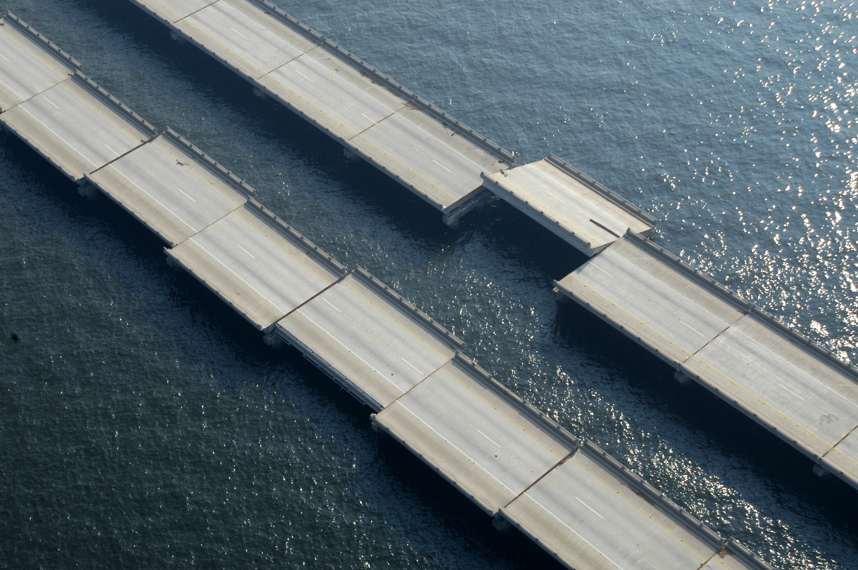
The I-10 Twin Span Bridge, officially known as the Frank Davis "Naturally N'Awlins" Memorial Bridge, is a nearly causeway near New Orleans. It consists of two parallel trestle bridges. These parallel bridges cross the eastern end of Lake Pontchartrain in southern Louisiana from New Orleans to Slidell. The current bridge spans were constructed in the second half of the 2000s after the original bridges were extensively damaged by Hurricane Katrina on August 29, 2005. The first span opened to eastbound traffic on July 9, 2009. On April 7, 2010, the second span was opened to traffic and the old twin spans were permanently closed to traffic. The approaches to the westbound lanes were completed with a ribbon-cutting ceremony on September 8, 2011, and the opening of all six lanes the next morning. The original Twin Span bridges were demolished shortly after the replacement spans opened. A short portion remains in use as a public fishing pier in Slidell. The debris from the demoli ... [...More Info...] [...Related Items...] OR: [Wikipedia] [Google] [Baidu] |
Chef Menteur Pass
The Chef Menteur Pass is a narrow natural waterway which, along with the Rigolets, connects Lake Pontchartrain and Lake Borgne in New Orleans, Louisiana. It begins at and follows a generally southeastward course. In the days of sailing ships, much commerce from the Gulf of Mexico sailed through the pass and the Rigolets into Lake Pontchartrain to New Orleans and surrounding communities. The Lake Catherine neighborhood of New Orleans is to the east side of the pass. The Venetian Isles neighborhood of New Orleans is to the west of the pass. Chef Menteur Pass was long guarded by Fort Macomb, now an abandoned ruin on the western side of the pass. Two bridges span the pass. The automobile bridge, constructed in 1929, carries U.S. Highway 90; the portion of this road between central New Orleans and the pass was long known as "Chef Menteur Road" before the route became a U.S. highway. Portions are still known as "Chef Menteur Highway." The CSX railroad bridge also spans Chef Menteur ... [...More Info...] [...Related Items...] OR: [Wikipedia] [Google] [Baidu] |


