|
Reuschberg (Spessart)
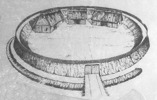
Reuschberg (Spessart) is a hill in the Spessart range, located in the Landkreis Aschaffenburg, part of the Franconia region of Bavaria, Germany. It has an elevation of 415 metres. The wooded hill is located mostly in the unincorporated area of '. At its foot lies the town of Schöllkrippen. To the south is the valley of the Höllenbach, to the north that of the Kleiner Laudenbach, both of which flow into the Kahl. There is a transmission mast on the hill, operated by Vodafone, located on the slope at an elevation of around 385 metres. Near the hilltop, there is a circular rampart, known as ' or ''Altenburg'', with remains of both earth and masonry walls, long thought to date to the La Tène period. However, excavations in 2005 indicate that it most likely is a 10th-century refuge castle A refuge castleCreighton, Oliver (2015). ''Early European Castles''. Bloomsbury. or refuge fort (, also ''Fluchtburg'', ''Volksburg'', ''Bauernburg'' or ''Vryburg'') is a castle-like defens ... [...More Info...] [...Related Items...] OR: [Wikipedia] [Google] [Baidu] |
Bavaria
Bavaria, officially the Free State of Bavaria, is a States of Germany, state in the southeast of Germany. With an area of , it is the list of German states by area, largest German state by land area, comprising approximately 1/5 of the total land area of Germany, and with over 13.08 million inhabitants, it is the list of German states by population, second most populous German state, behind only North Rhine-Westphalia; however, due to its large land area, its population density is list of German states by population density, below the German average. Major cities include Munich (its capital and List of cities in Bavaria by population, largest city, which is also the list of cities in Germany by population, third largest city in Germany), Nuremberg, and Augsburg. The history of Bavaria includes its earliest settlement by Iron Age Celts, Celtic tribes, followed by the conquests of the Roman Empire in the 1st century BC, when the territory was incorporated into the provinces of Ra ... [...More Info...] [...Related Items...] OR: [Wikipedia] [Google] [Baidu] |
Germany
Germany, officially the Federal Republic of Germany, is a country in Central Europe. It lies between the Baltic Sea and the North Sea to the north and the Alps to the south. Its sixteen States of Germany, constituent states have a total population of over 84 million in an area of , making it the most populous member state of the European Union. It borders Denmark to the north, Poland and the Czech Republic to the east, Austria and Switzerland to the south, and France, Luxembourg, Belgium, and the Netherlands to the west. The Capital of Germany, nation's capital and List of cities in Germany by population, most populous city is Berlin and its main financial centre is Frankfurt; the largest urban area is the Ruhr. Settlement in the territory of modern Germany began in the Lower Paleolithic, with various tribes inhabiting it from the Neolithic onward, chiefly the Celts. Various Germanic peoples, Germanic tribes have inhabited the northern parts of modern Germany since classical ... [...More Info...] [...Related Items...] OR: [Wikipedia] [Google] [Baidu] |
Spessart
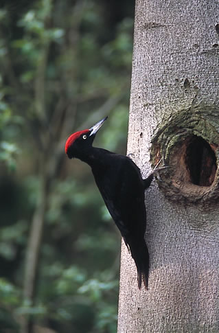
Spessart () is a ''Mittelgebirge'', a range of low wooded mountains, in the States of Bavaria and Hesse in Germany. It is bordered by the Vogelsberg, Rhön and Odenwald. The highest elevation is the Geiersberg (Spessart), Geiersberg at 586 metres above sea level. Etymology The name is derived from "Spechtshardt". ''Specht'' is the German word for woodpecker and ''Hardt'' is an outdated word meaning "hilly forest". Geography Location The Spessart is a ''Mittelgebirge'', part of the German Central Uplands, located in the Lower Franconia region of Bavaria and in Hesse, Germany. It is bordered by other ranges of hills: the Vogelsberg in the north, Rhön in the northeast and Odenwald in the southwest. Another way of describing the extent of the range is by naming the rivers that border it: the Main (river), Main in the south and west, the Kinzig (Main), Kinzig in the north and the Sinn (river), Sinn in the northeast. The area of the Spessart totals around 2,440 square kilometre ... [...More Info...] [...Related Items...] OR: [Wikipedia] [Google] [Baidu] |
Aschaffenburg (district)
Aschaffenburg (Low Franconian: ) is a (district) in Bavaria, Germany. It is bounded by (from the west and clockwise) the districts of Darmstadt-Dieburg, Offenbach, Main-Kinzig (all in the state of Hesse), the districts Main-Spessart and Miltenberg, and the City of Aschaffenburg. History The history of Aschaffenburg goes back as far as the year 957. Initially a Roman settlement, it came under the authority of the electors of Mainz in 982 and was chartered in 1173. Remains of Roman settlements were found on the river Main. There was a Roman military camp in today's municipality of Stockstadt am Main. After the Roman retreat, the region became subject to Alemanni and Franks before becoming a part of the Electorate of Mainz. While the banks of the Main were populated all these centuries, the hills of the Spessart were virtually unsettled until the 13th century. The districts of Aschaffenburg and Alzenau were established in 1862, half a century after the state of Bavaria had a ... [...More Info...] [...Related Items...] OR: [Wikipedia] [Google] [Baidu] |
Unincorporated Area
An unincorporated area is a parcel of land that is not governed by a local general-purpose municipal corporation. (At p. 178.) They may be governed or serviced by an encompassing unit (such as a county) or another branch of the state (such as the military). There are many unincorporated communities and areas in the United States and Canada, but many countries do not use the concept of an unincorporated area. By country Argentina In Argentina, the provinces of Chubut Province, Chubut, Córdoba Province (Argentina), Córdoba, Entre Ríos Province, Entre Ríos, Formosa Province, Formosa, Neuquén Province, Neuquén, Río Negro Province, Río Negro, San Luis Province, San Luis, Santa Cruz Province, Argentina, Santa Cruz, Santiago del Estero Province, Santiago del Estero, Tierra del Fuego Province, Argentina, Tierra del Fuego, and Tucumán Province, Tucumán have areas that are outside any municipality or commune. Australia Unlike many other countries, Australia has only local go ... [...More Info...] [...Related Items...] OR: [Wikipedia] [Google] [Baidu] |
Schöllkrippen
Schöllkrippen is a market community in the Aschaffenburg (district), Aschaffenburg district in the ''Regierungsbezirk'' of Lower Franconia (''Unterfranken'') in Bavaria, Germany and seat of the ''Municipal association, Verwaltungsgemeinschaft'' (municipal association) of Schöllkrippen. It had a total population of around 4,300 in 2020, and experienced a decrease down to 4112 in 2023 Geography Location Schöllkrippen is the largest settlement of the Kahlgrund and lies on the river Kahl (river), Kahl on the western edge of the Spessart (range). The main ''Ortsteil'' of Schöllkrippen lies at the foot of the Reuschberg (Spessart), Reuschberg. Subdivisions Schöllkrippen's ''Ortsteile'' are Schöllkrippen, and . Schöllkrippen ''Ortsteil'' consists of the following ''Orte'': , , , Röderhof, and Schöllkrippen proper. Neighbouring communities The neighbouring communities are from the north (clockwise): Westerngrund, Kleinkahl, (an unincorporated area), Sommerkahl, Blankenbac ... [...More Info...] [...Related Items...] OR: [Wikipedia] [Google] [Baidu] |
Höllenbach (Kahl)
The Höllenbach is a small river of Bavaria, Germany. It is a left tributary of the Kahl in Schöllkrippen. The Höllenbach rises at the Röderhof on the Reuschberg (415 m). It flows westwards through a water protection area , past the nature adventure pool to Schöllkrippen. There it flows into the Kahl opposite the mouth of the Westerbach, under the intersection of state roads 2305 and 2306. See also *List of rivers of Bavaria A list of rivers of Bavaria, Germany: A * Aalbach * Abens * Ach * Afferbach * Affinger Bach * Ailsbach * Aisch * Aiterach * Alpbach *Alster * Altmühl * Alz * Amper * Anlauter * Arbach * Arbachgraben * Aschaff * Aschbach * Attel * Aubach, tributa ... Rivers of Bavaria Rivers of the Spessart Rivers of Germany {{Bavaria-river-stub ... [...More Info...] [...Related Items...] OR: [Wikipedia] [Google] [Baidu] |
Kleinlaudenbach (Kahl)
The Kleinlaudenbach, also called Kleiner Laudenbach, is a river of Bavaria, Germany. It is a left tributary of the Kahl near Kleinkahl. The Kleinlaudenbach rises on the Degen-Weg in the Schöllkrippener Forest at the foot of the Eselshöhe ridge , below the ''Laudenberg'' (478 m). See also *List of rivers of Bavaria A list of rivers of Bavaria, Germany: A * Aalbach * Abens * Ach * Afferbach * Affinger Bach * Ailsbach * Aisch * Aiterach * Alpbach *Alster * Altmühl * Alz * Amper * Anlauter * Arbach * Arbachgraben * Aschaff * Aschbach * Attel * Aubach, tributa ... Rivers of Bavaria Rivers of the Spessart Rivers of Germany {{Bavaria-river-stub ... [...More Info...] [...Related Items...] OR: [Wikipedia] [Google] [Baidu] |
Kahl (river)
The Kahl is a river in the northern Spessart in Bavaria and Hesse, Germany. It is a right tributary of the Main and is long. The name Kahl comes from the Old High German word ''kaldaha'', which means cool and clear. The Kahl rises from two sources left and right of the road at the foot of the Spessart hills, near Kleinkahl. These springs produce 50–60 litres per second. The Kahl flows into the Main in Kahl am Main near the old Kahl Nuclear Power Plant. The largest tributaries are Westerbach, Sommerkahl, Reichenbach and Geiselbach. Tributaries Tributaries from source to mouth: Left * Büchelbach * Edelbach * Kleine Kahl * Kleinlaudenbach * Höllenbach * Sommerkahl * Blankenbach * Erlenbach * Feldkahl * Weibersbach (not to be confused with the right tributary) * Reichenbach * Forstgraben * Rappach * Fleutersbach * Hemsbach * Hitziger Lochgraben * Kertelbach * Krebsbach * Neuwiesenbach Right * Lindenbach * Habersbach * Westerbach * Krombach * Sterzenbach ... [...More Info...] [...Related Items...] OR: [Wikipedia] [Google] [Baidu] |
Circular Rampart
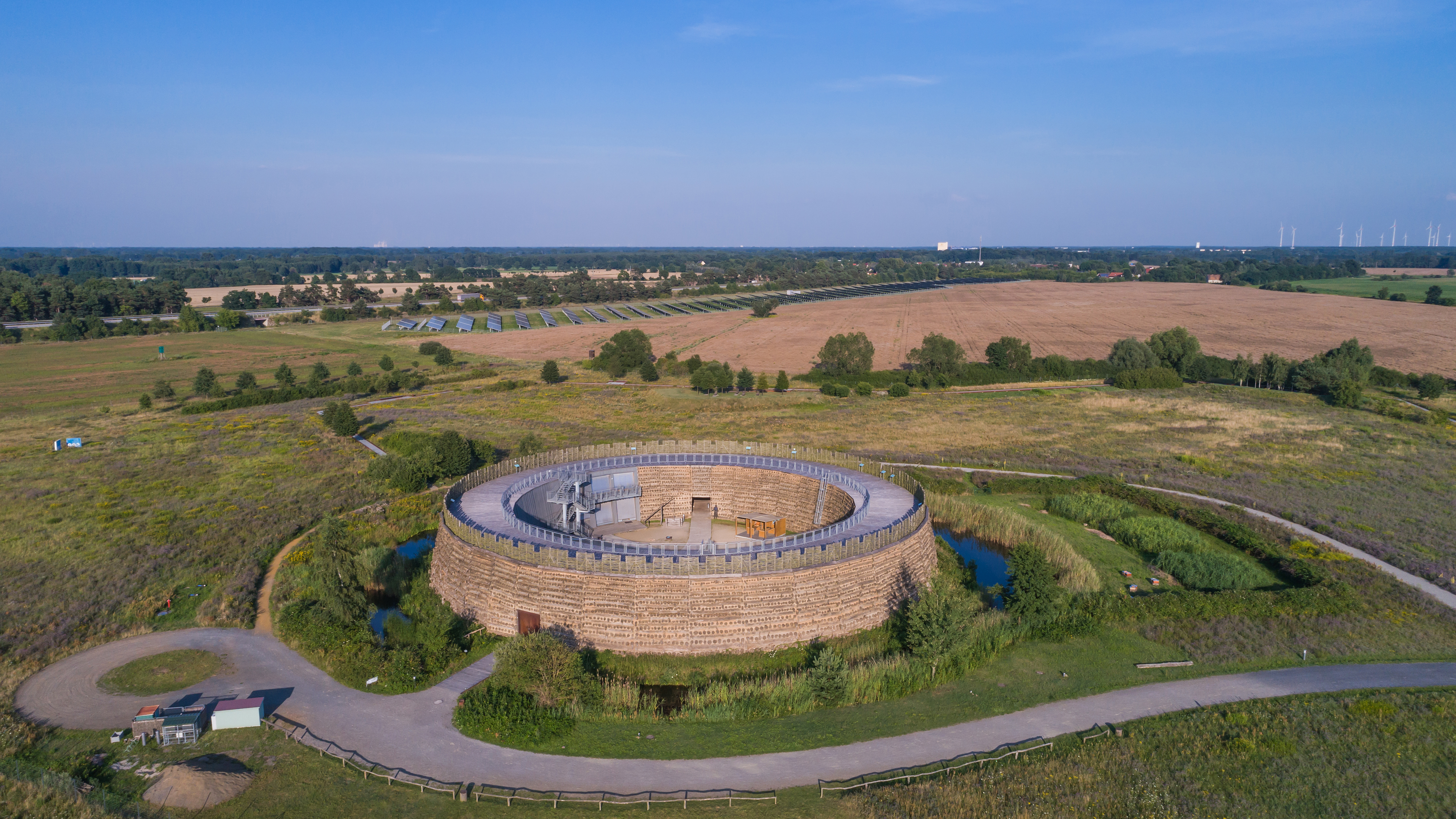
A circular rampart () is an embankment built in the shape of a circle that was used as part of the defences for a military fortification, hill fort or refuge, or was built for religious purposes or as a place of gathering. The period during which these structures were built ranged from the Neolithic to the Middle Ages. Construction The key feature of a circular Rampart (fortification), rampart is that the Earthworks (engineering)#Military use, embankment formed the primary element of the defensive fortification.Radig (1935), pp. 9–10. It can be constructed in various ways: as a simple earth embankment, as a wood and earth structure, or as a wall. Circular ramparts usually have a moat or Ditch (fortification), ditch in front of them; the embankment can be enhanced with a wooden palisade. They are mostly found on lowlands, but sometimes encircle the summit of a hill. Often several concentric rings were built, which produced a more effective defensive position against attackers. T ... [...More Info...] [...Related Items...] OR: [Wikipedia] [Google] [Baidu] |
La Tène Culture
The La Tène culture (; ) was a Iron Age Europe, European Iron Age culture. It developed and flourished during the late Iron Age (from about 450 BC to the Roman Republic, Roman conquest in the 1st century BC), succeeding the early Iron Age Hallstatt culture without any definite cultural break, under considerable Mediterranean influence from the Greeks in pre-Roman Gaul, the Etruscan civilization, Etruscans, and the Culture of Golasecca, Golasecca culture, but whose artistic style nevertheless did not depend on those Mediterranean influences. La Tène culture's territorial extent corresponded to what is now Prehistory of France#The Iron Age, France, History of Belgium#Celtic and Roman periods, Belgium, Early history of Switzerland#Iron Age, Switzerland, History of Austria#Iron Age, Austria, History of England#Later Prehistory, England, History of Germany#Iron Age, Southern Germany, the History of the Czech lands#Iron Age, Czech Republic, Prehistoric Italy#Iron Age, Northern ... [...More Info...] [...Related Items...] OR: [Wikipedia] [Google] [Baidu] |
Refuge Castle
A refuge castleCreighton, Oliver (2015). ''Early European Castles''. Bloomsbury. or refuge fort (, also ''Fluchtburg'', ''Volksburg'', ''Bauernburg'' or ''Vryburg'') is a castle-like defensive location, usually surrounded by Rampart (fortification), ramparts, that is not permanently occupied but acts as a temporary retreat for the local population when threatened by war or attack. In former times such sites were also described as giant castles (German: ''Hünenburgen'') because their origin was ascribed to Giant (mythology), giants. History In Europe a multitude of large protohistoric sites surrounded by earthworks has been uncovered by archaeological excavations, many over 100 metres in diameter, that are understood to be refuge castles. Amongst ancient historical references to them are the refuge castles of the Gauls described by Julius Caesar, Caesar as ''oppida'', although they could also be permanent settlements. Similar ringwork (''Ringwall'') systems were built by th ... [...More Info...] [...Related Items...] OR: [Wikipedia] [Google] [Baidu] |


