|
Rendalen Municipality
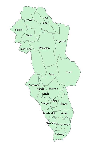
Rendalen is a municipality in Innlandet county, Norway. It is located in the traditional district of Østerdalen. The administrative centre of the municipality is the village of Bergset. Other villages in the municipality include Hanestad, Otnes, Sjølisand, Unset, Åkre, and Åkrestrømmen. The municipality is the 13th largest by area out of the 357 municipalities in Norway. Rendalen is the 292nd most populous municipality in Norway with a population of 1,846. The municipality's population density is and its population has decreased by 2.4% over the previous 10-year period. General information The municipality of Rendalen was established on 1 January 1965 when the old Ytre Rendal Municipality (population: 1,913) and Øvre Rendal Municipality (population: 1,629) were merged. On 1 January 1984, the unpopulated Spekedalen valley was transferred from Tynset Municipality to Rendalen. Historically, the municipality was part of Hedmark county. On 1 January 2020, the municipality ... [...More Info...] [...Related Items...] OR: [Wikipedia] [Google] [Baidu] |
Bergset
Bergset is the administrative centre of Rendalen Municipality in Innlandet county, Norway. The village is located on the western shore of the river Renaelva, about north of the village of Otnes in the largely rural Østerdalen valley. The village had a population (2012) of 243 and a population density of . Since 2012, the population and area data for this village area has not been separately tracked by Statistics Norway. History Bergset was also the administrative centre of the former Øvre Rendal Municipality which is now a part of Rendalen Municipality. Øvre Rendal Church, built in 1761, is located in Bergset. The Bull Museum, Rendalen Village Museum in Bergset contains a collection relating to the author Jacob Breda Bull (1853–1930), who was a resident of Rendalen. Bull was buried in the nearby Ytre Rendal Church. References External linksRendalen Bygdemuseum website {{use dmy dates, date=February 2022 Rendalen Villages in Innlandet ... [...More Info...] [...Related Items...] OR: [Wikipedia] [Google] [Baidu] |
Åkrestrømmen
Åkrestrømmen is a village in Rendalen Municipality in Innlandet county, Norway Norway, officially the Kingdom of Norway, is a Nordic countries, Nordic country located on the Scandinavian Peninsula in Northern Europe. The remote Arctic island of Jan Mayen and the archipelago of Svalbard also form part of the Kingdom of .... The village is located along the river Renaelva at the northern end of the lake Storsjøen, about south of the village of Åkre. The town of Koppang lies about to the southwest of Åkrestrømmen. References Rendalen Villages in Innlandet {{Innlandet-geo-stub ... [...More Info...] [...Related Items...] OR: [Wikipedia] [Google] [Baidu] |
Azure (heraldry)
In heraldry, azure ( , ) is the tincture (heraldry), tincture with the colour azure (color), blue, and belongs to the class of tinctures called "colours". In engraving, it is sometimes depicted as a region of horizontal lines or else is marked with either az. or b. as an abbreviation. The term azure shares its origin with the Spanish word "azul", which refers to the same color, deriving from Hispanic Arabic ''lāzaward'', the name of the deep blue stone now called lapis lazuli. The word was adopted into Old French by the 12th century, after which the word passed into use in the blazon of coat of arms, coats of arms. As a heraldic colour, the word azure means "blue", and reflects the name for the colour in the Anglo-Norman language, Anglo-Norman dialect spoken by French-speaking Norman nobles following the Norman Conquest of England. A wide range of colour values is used in the depiction of azure in armory and flags, but in common usage it is often referred to simply as "blue". ... [...More Info...] [...Related Items...] OR: [Wikipedia] [Google] [Baidu] |
Blazon
In heraldry and heraldic vexillology, a blazon is a formal description of a coat of arms, flag or similar emblem, from which the reader can reconstruct an accurate image. The verb ''to blazon'' means to create such a description. The visual depiction of a coat of arms or flag has traditionally had considerable latitude in design, but a verbal blazon specifies the essentially distinctive elements. A coat of arms or flag is therefore primarily defined not by a picture but rather by the wording of its blazon (though in modern usage flags are often additionally and more precisely defined using geometrical specifications). ''Blazon'' is also the specialized language in which a blazon is written, and, as a verb, the act of writing such a description. ''Blazonry'' is the art, craft or practice of creating a blazon. The language employed in ''blazonry'' has its own vocabulary and syntax, which becomes essential for comprehension when blazoning a complex coat of arms. Other armorial ob ... [...More Info...] [...Related Items...] OR: [Wikipedia] [Google] [Baidu] |
Coat Of Arms
A coat of arms is a heraldry, heraldic communication design, visual design on an escutcheon (heraldry), escutcheon (i.e., shield), surcoat, or tabard (the last two being outer garments), originating in Europe. The coat of arms on an escutcheon forms the central element of the full achievement (heraldry), heraldic achievement, which in its whole consists of a shield, supporters, a crest (heraldry), crest, and a motto. A coat of arms is traditionally unique to the armiger (e.g. an individual person, family, state, organization, school or corporation). The term "coat of arms" itself, describing in modern times just the heraldic design, originates from the description of the entire medieval chainmail "surcoat" garment used in combat or preparation for the latter. Roll of arms, Rolls of arms are collections of many coats of arms, and since the early Modern Age centuries, they have been a source of information for public showing and tracing the membership of a nobility, noble family, a ... [...More Info...] [...Related Items...] OR: [Wikipedia] [Google] [Baidu] |
Renaelva
The Rena or Renaelva is a river in Innlandet county, Norway. The long river runs through Rendalen Municipality and Åmot Municipality in Innlandet county. This river is a tributary of the large river Glomma. Kjøllsæter Bridge connects the east and west side of the river. The river Julussa flows from south through the Julussdalen valley and into the river Rena. The Rena watershed has a drainage area of . The river begins at the confluence of the rivers Tysla and Unsetåa which is just south of the Fonnåsfjellet mountain and just north of the village of Bergset. The river flows south through the lakes Lomnessjøen and Storsjøen and when the river reaches the village of Rena, just flows into the large river Glomma. A tunnel has been built to transport part of the water from the upper Glomma The Glomma or Glåma is Norway's longest and most voluminous river. With a total length of , it has a drainage basin that covers 13% of Norway's surface area, all in the southern ... [...More Info...] [...Related Items...] OR: [Wikipedia] [Google] [Baidu] |
Valley
A valley is an elongated low area often running between hills or mountains and typically containing a river or stream running from one end to the other. Most valleys are formed by erosion of the land surface by rivers or streams over a very long period. Some valleys are formed through erosion by glacial ice. These glaciers may remain present in valleys in high mountains or polar areas. At lower latitudes and altitudes, these glacially formed valleys may have been created or enlarged during ice ages but now are ice-free and occupied by streams or rivers. In desert areas, valleys may be entirely dry or carry a watercourse only rarely. In areas of limestone bedrock, dry valleys may also result from drainage now taking place underground rather than at the surface. Rift valleys arise principally from earth movements, rather than erosion. Many different types of valleys are described by geographers, using terms that may be global in use or else applied only locally ... [...More Info...] [...Related Items...] OR: [Wikipedia] [Google] [Baidu] |
Reindeer
The reindeer or caribou (''Rangifer tarandus'') is a species of deer with circumpolar distribution, native to Arctic, subarctic, tundra, taiga, boreal, and mountainous regions of Northern Europe, Siberia, and North America. It is the only representative of the genus ''Rangifer''. More recent studies suggest the splitting of reindeer and caribou into six distinct species over their range. Reindeer occur in both Animal migration, migratory and wiktionary:sedentary#Adjective, sedentary populations, and their herd sizes vary greatly in different regions. The tundra subspecies are adapted for extreme cold, and some are adapted for long-distance migration. Reindeer vary greatly in size and color from the smallest, the Svalbard reindeer (''R.'' (''t.'') ''platyrhynchus''), to the largest, Osborn's caribou (''R. t. osborni''). Although reindeer are quite numerous, some species and subspecies are in decline and considered Vulnerable species, vulnerable. They are unique among deer (Ce ... [...More Info...] [...Related Items...] OR: [Wikipedia] [Google] [Baidu] |
Prestegjeld
A ''prestegjeld'' was a geographic and administrative area within the Church of Norway (''Den Norske Kirke'') roughly equivalent to a parish. This traditional designation was in use for centuries to divide the kingdom into ecclesiastical areas that were led by a parish priest. ''Prestegjelds'' began in the 1400s and were officially discontinued in 2012. History Prior to the discontinuation of the ''prestegjeld'', Norway was geographically divided into 11 dioceses (''bispedømme''). Each diocese was further divided into deaneries (''prosti''). Each of those deaneries were divided into several parishes (''prestegjeld''). Each parish was made up of one or more sub-parishes or congregations (''sogn'' or ''sokn''). Within a ''prestegjeld'', there were usually one or more clerical positions ( chaplains) serving under the administration of a head minister (''sogneprest'' or ''sokneprest''). In 1838, the formannskapsdistrikt () was the name of a Norwegian self-governing municipalit ... [...More Info...] [...Related Items...] OR: [Wikipedia] [Google] [Baidu] |
Oppland
Oppland is a former county in Norway which existed from 1781 until its dissolution on 1 January 2020. The old Oppland county bordered the counties of Trøndelag, Møre og Romsdal, Sogn og Fjordane, Buskerud, Akershus, Oslo and Hedmark. The county administration was located in the town of Lillehammer. Merger On 1 January 2020, the neighboring counties of Oppland and Hedmark were merged to form the new Innlandet county. Both Oppland and Hedmark were the only landlocked counties of Norway, and the new Innlandet county is the only landlocked county in Norway. The two counties had historically been one county that was divided in 1781. Historically, the region was commonly known as " Opplandene". In 1781, the government split the area into two: Hedemarkens amt and Kristians amt (later renamed Hedmark and Oppland). In 2017, the government approved the merger of the two counties. There were several names debated, but the government settled on ''Innlandet''. Geography Oppland ext ... [...More Info...] [...Related Items...] OR: [Wikipedia] [Google] [Baidu] |
Hedmark
Hedmark () was a Counties of Norway, county in Norway from 1 January 1919 to 31 December 2019, bordering Trøndelag to the north, Oppland to the west, Akershus to the south, and Sweden to the east. The county administration is in Hamar. Hedmark and Oppland counties were merged into Innlandet county on 1 January 2020, when Norway's former 19 counties became 10 bigger counties / regions. Hedmark made up the northeastern part of Østlandet, the southeastern part of the country. It had a long border with Sweden to the east (Dalarna County and Värmland County). The largest lakes were Femunden and Mjøsa, the largest lake in Norway. Parts of Glomma, Norway's longest river, flowed through Hedmark. Geographically, Hedmark was traditionally divided into: Hedemarken (east of the lake Mjøsa), Østerdalen ("East Valley" north of the town Elverum (town), Elverum), and Solør / Glåmdalen (south of Elverum) and Odal, Norway, Odal in the very south. Hedmark and Oppland were the only Norweg ... [...More Info...] [...Related Items...] OR: [Wikipedia] [Google] [Baidu] |


