|
Reichenau, Carinthia
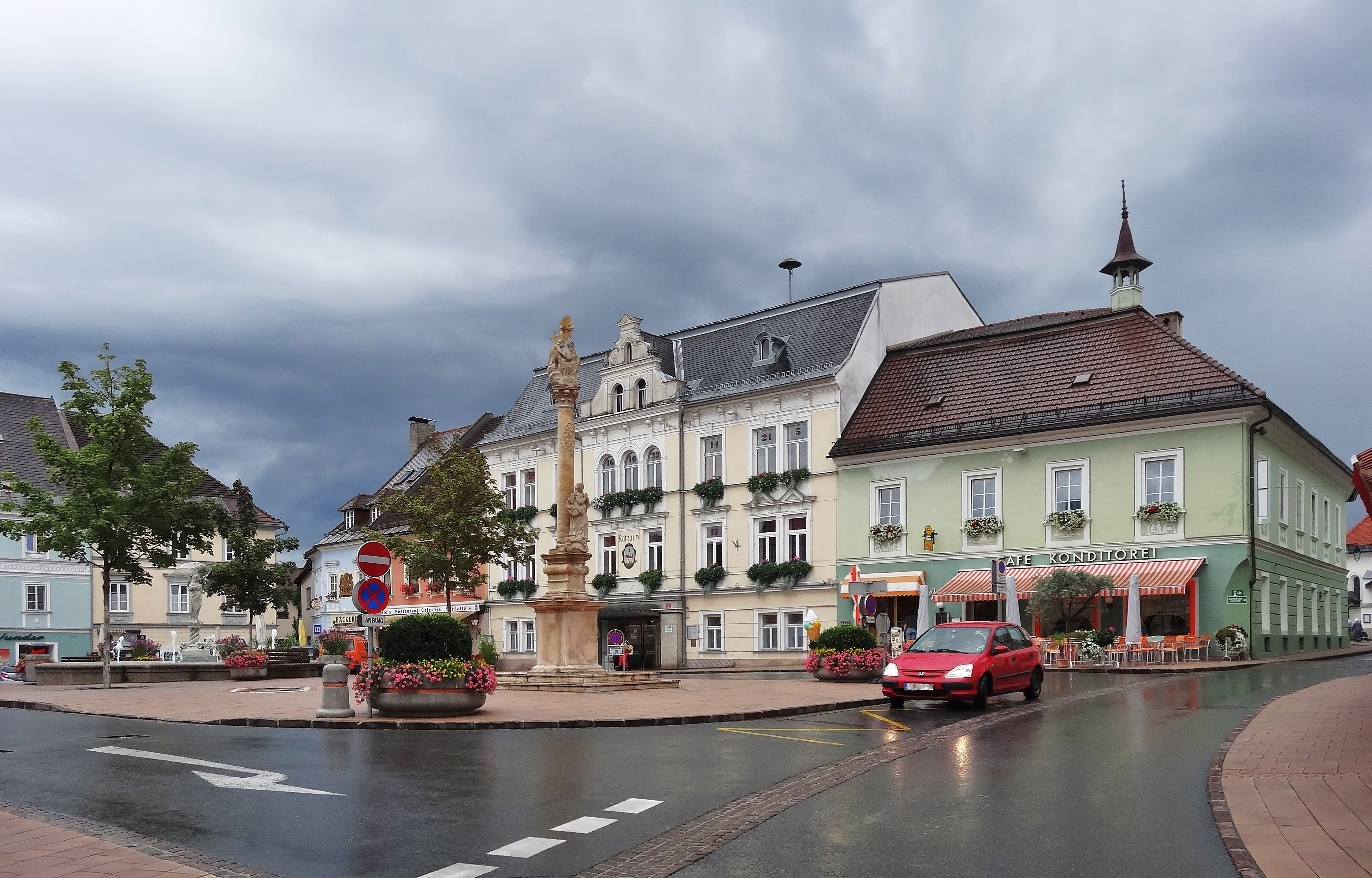
Reichenau () is a municipality in the district of Feldkirchen (district), Feldkirchen in the Austrian state of Carinthia (state), Carinthia. Geography The municipal area is situated in the upper valley of the Gurk (river), Gurk River within the Nock Mountains range (part of the Gurktal Alps). In the north, the road from Feldkirchen in Kärnten, Feldkirchen leads up to Turracher Höhe Pass and Turracher See at a height of Metres above the Adriatic, AA on the border with Predlitz-Turrach in Styria and further down into the Mur (river), Mur Valley. Another small mountain lake is Falkertsee at in the west. Reichenau is the eastern terminus of the ''Nockalmstraße'' scenic route through the Nock Mountains to Krems, Carinthia, Krems. Reichenau consists of the Cadastral community, cadastral communities Ebene Reichenau, Sankt Lorenzen, Sankt Margarethen, Wiedweg, and Winkl. Neighboring municipalities History The remote and densely forested area of the upper Gurk Valley was settled ... [...More Info...] [...Related Items...] OR: [Wikipedia] [Google] [Baidu] |
Municipality (Austria)
In the Republic of Austria, the municipality (, sometimes also ) is the administrative division encompassing a single village, town, or city. The municipality has municipal corporation, corporate status and local self-government on the basis of parliamentary democracy, parliamentary-style representative democracy: a municipal council () elected through a form of party-list proportional representation, party-list system enacts municipal laws, a municipal executive board () and a mayor (, grammatical gender, fem. ) appointed by the council are in charge of municipal administration. Austria is currently (January 1, 2020) partitioned into 2,095 municipalities, ranging in population from about fifty (the village of Gramais in Tyrol (state), Tyrol) to almost two million (the city of Vienna). There is no unincorporated area, unincorporated territory in Austria. Basics The existence of municipalities and their role as carriers of the right to self-administration are guaranteed by the ... [...More Info...] [...Related Items...] OR: [Wikipedia] [Google] [Baidu] |
Feldkirchen In Kärnten
Feldkirchen in Kärnten is a town in the Austrian state of Carinthia and the capital of the district of the same name. It consists of the Katastralgemeinden ''Fasching'', ''Feldkirchen'', ''Glanhofen'', ''Gradisch'', ''Hoefling'', ''Klein Sankt Veit'', ''Pernegg'', ''Rabensdorf'', ''Sankt Ulrich'', ''Sittich'', ''Tschwarzen'' and ''Waiern''. The name ''Feldkirchen'' means the church in the fields. Geography Location Feldkirchen is located on the northern edge of the Klagenfurt Basin at the junction of the federal highways (''Bundesstraßen'') ''B 93 Gurktal Straße'' toward Friesach, ''B 94 Ossiacher Straße'' to Villach and ''B 95 Turracher Straße'' to Klagenfurt. Waters Both the Glan river and the small ''Tiebel'', main inflow of Lake Ossiach, run through the town. There are three lakes in the vicinity to Feldkirchen * The Lake of Flatschach (''Flatschacher See'') * The Lake of Dietrichstein (''Dietrichsteiner See'') * The Lake of Maltschach (''Maltschacher See'') Fl ... [...More Info...] [...Related Items...] OR: [Wikipedia] [Google] [Baidu] |
Albeck, Carinthia
Albeck is a municipality in the district of Feldkirchen in the Austrian state of Carinthia. Geography The municipal area stretches along the valley of the Sirnitzbach creek, a tributary of the Gurk river, within the Gurktal Alps. In the northwest, Albeck borders on the state of Styria near Mt Eisenhut and Turracher Höhe Pass. In the west, the road leads from Sirnitz to Reichenau via Hochrindl Pass. The upper Gurk valley and its sources, two small cirque lakes (Gurksee and Torersee), are a protected area since 1981. Albeck comprises the cadastral communities of Albeck proper, Großreichenau, Sankt Leonhard, and Sirnitz. The main settlement is the village of Sirnitz. Neighbouring municipalities History Albeck is a settlement area since the 10th century, when the surrounding estates were held by the Counts of Friesach, ancestors of Saint Hemma of Gurk. In 1043 Hemma granted the Lordship of Albeck to the short-lived Benedictine nunnery of Gurk. When Archbishop Gebhard o ... [...More Info...] [...Related Items...] OR: [Wikipedia] [Google] [Baidu] |
Bad Kleinkirchheim
Bad Kleinkirchheim is a municipality and spa town in the district of Spittal an der Drau, in Carinthia, Austria. Until the middle of the 20th century, agriculture was the dominant focus, but it is now a renowned spa and ski resort. Although records show people appreciating the area as a recreation area as early as the 11th century, and the first bathing guests arriving in the 17th century, it was only in the last few decades that Bad Kleinkirchheim began to move away from agriculture and focus on its potential for tourism. Geography Location Bad Kleinkirchheim is at an average elevation of in a stretch of a glacial trough valley in the Gurktal Alps ( Nock Mountains), between the Millstätter See and the upper Gurk River. The populated section lies between and , and the highest point in the area is the peak of the Klomnock, at . North of Kleinkirchheim and St. Oswald, part of the Nockberge National Park is within the area’s boundaries. To the north and south of the valle ... [...More Info...] [...Related Items...] OR: [Wikipedia] [Google] [Baidu] |
Cadastral Community
A cadastral community (or cadastre community, cadastral r cadastremunicipality, cadastral r cadastrecommune,Problémy s překladem termínu „katastrální území“ do angličtiny. in: Geodetický a kartografický Obzor. Český úřad zeměměřický a katastrální, Úrad geodézie, kartografie a katastra Slovenskej republiky. 3, March 2015. p. 66, 67 cadastral r cadastreunit, cadastral r cadastredistrict, cadastral r cadastrearea, cadastral r cadastreterritory) is a cadastral subdivision of municipalities in the nations of Austria,Cadastral Template for Austria, web-pageCT-AT Bosnia and Herzegovina, Croatia, the Czech Republic, Serbia, Slovakia, Slovenia, the Netherlands, and the Italian provinces of South Tyrol, Trentino, Gorizia and Trieste. A cadastral community records property ownership in a cadastre, which is a register describing property ownership by boundary lines of the real estate. The common etymology in the Central European successor states of the ... [...More Info...] [...Related Items...] OR: [Wikipedia] [Google] [Baidu] |
Krems, Carinthia
Krems in Kärnten is a municipality in the district of Spittal an der Drau (district), Spittal an der Drau in Carinthia (state), Carinthia in Austria. Geography The municipal area is located in the Krems Valley of northern Carinthia, at the border with the Austrian States of Austria, states of Salzburg (state), Salzburg (Tamsweg District, Lungau) and Styria (Upper Styria). It stretches down from the Lieser River, a tributary of the Drava, up to the Nock Mountains, part of the Gurktal Alps range. The village of Innerkrems is the starting point of the scenic Nockalm Road to Reichenau, Carinthia, Reichenau, in the north the Schönfeldsattel Pass leads to Thomatal (Bundschuh) in Salzburg. To the west, the Katschberg Pass road and the parallel Tauern Autobahn are significant transport routes. The mountainous region is a popular winter sport destination, including several Alpine skiing, ski slopes and platter lifts. The Krems municipality is subdivided into seven cadastral community, ... [...More Info...] [...Related Items...] OR: [Wikipedia] [Google] [Baidu] |
Scenic Route
A scenic route, tourist road, tourist drive, scenic byway, or holiday road is a specially designated road or waterway that travels through an area of natural or cultural beauty. It often passes by scenic viewpoints. The designation is usually determined by a governmental body, such as a Department of Transportation or a Ministry of Transport. Tourist highway A tourist highway, tourist route, or holiday route is a road that is marketed as being particularly suited for tourists. Tourist highways may be formed when existing roads are promoted with traffic signs and advertising material. Some tourist highways such as the Blue Ridge Parkway are built especially for tourism purposes. Others may be roadways enjoyed by local citizens in areas of unique or exceptional natural beauty, such as the Lake District. Still others, such as the Lincoln Highway in Illinois are former main roads, only designated as "scenic" after most traffic bypasses them (termed scenic highway in the United St ... [...More Info...] [...Related Items...] OR: [Wikipedia] [Google] [Baidu] |
Falkertsee
Falkertsee is a lake of Carinthia, Austria Austria, formally the Republic of Austria, is a landlocked country in Central Europe, lying in the Eastern Alps. It is a federation of nine Federal states of Austria, states, of which the capital Vienna is the List of largest cities in Aust .... Lakes of Carinthia {{Carinthia-geo-stub ... [...More Info...] [...Related Items...] OR: [Wikipedia] [Google] [Baidu] |
Mur (river)
The Mur () or Mura (; ; ; Prekmurje Slovene: ''Müra''Novak, Vilko. 2006. ''Slovar stare knjižne prekmurščine''. Ljubljana: ZRC SAZU, pp. 262, 269. or ''Möra'') is a river in Central Europe rising in the Hohe Tauern national park of the Central Eastern Alps in Austria with its source at above sea level. It is a tributary of the Drava and subsequently the Danube. The Mur's total length is around . About 326 km are within the interior of Austria; 95 km flow in and around Slovenia (67 km along the borders with Austria and Croatia, 28 km inside Slovenia), and the rest forms the border between Croatia and Hungary. The largest city on the river is Graz, Austria. Its drainage basin covers an area of . Tributary, Tributaries of the Mur include the Mürz, the Sulm (Austria), Sulm, the Ščavnica, the Ledava and the Trnava (Međimurje), Trnava. Etymology The river was attested as ''Maura'' in AD 799, ''Muora'' in 890, ''Mura'' in 1259, ''Mvr'' and ''Mver'' ... [...More Info...] [...Related Items...] OR: [Wikipedia] [Google] [Baidu] |
Styria
Styria ( ; ; ; ) is an Austrian Federal states of Austria, state in the southeast of the country. With an area of approximately , Styria is Austria's second largest state, after Lower Austria. It is bordered to the south by Slovenia, and clockwise, from the southwest, by the other Austrian states of Carinthia, Salzburg (federal state), Salzburg, Upper Austria, Lower Austria, and Burgenland. The state's capital is Graz, the second largest city in Austria after only Vienna. Name The March of Styria derived its name from the original seat of its ruling Otakars, Otakar dynasty: Steyr, in today's Upper Austria, which in turn derives its name from the namesake river of Steyr, stemming from the Celtic Stiria. In the native German the area is still called "Steiermark", while in English the Latin name "Styria" is used. Until the late 19th century however, the German name "Steyer", a slightly modernized spelling of Steyr, was also common. The ancient link between the city of Steyr and S ... [...More Info...] [...Related Items...] OR: [Wikipedia] [Google] [Baidu] |
Predlitz-Turrach
Predlitz-Turrach is a former municipality in the district of Murau in Styria, Austria. Since the 2015 Styria municipal structural reform, it is part of the municipality Stadl-Predlitz. Geography The municipality lies in the upper valley of the Mur in the Gurktal Alps The Gurktal Alps (, ) is a mountain range in the Central Eastern Alps in Austria which is named after the valley of the Gurk river. The range stretches west to Lake Millstatt and east to Neumarkter Sattel (north-northwest of Neumarkt in Steie .... References Cities and towns in Murau District {{Styria-geo-stub ... [...More Info...] [...Related Items...] OR: [Wikipedia] [Google] [Baidu] |


