|
Real McCoy (ferry)
The ''Real McCoy'' was a ferryboat that operated for 63 years from Rio Vista, California on the Ryer Island Ferry route as part of California State Route 84, and was the oldest and most reliable piece of equipment owned by the California Department of Transportation. During its operating life – making the trip 24 hours per day, 7 days per week and roughly 200 trips a day – totaling approximately 460,000 safe passages over the 800 foot gap in the Sacramento River delta, between Ryer Island and Rio Vista. It was replaced in 2011 by the Real McCoy II The ''Real McCoy II'' is a ferryboat that has operated since 2011 from Rio Vista, California on the Ryer Island Ferry route as part of California State Route 84, operated by the California Department of Transportation. It replaced the original '' .... Notes Ferries on the California highway system Steamships of the United States Transportation in Solano County, California 1945 ships {{water-transport-stub ... [...More Info...] [...Related Items...] OR: [Wikipedia] [Google] [Baidu] |
California Department Of Transportation
The California Department of Transportation (Caltrans) is an executive department of the U.S. state of California. The department is part of the cabinet-level California State Transportation Agency (CalSTA). Caltrans is headquartered in Sacramento. Caltrans manages the state's highway system, which includes the California Freeway and Expressway System, supports public transportation systems throughout the state and provides funding and oversight for three state-supported Amtrak intercity rail routes ('' Capitol Corridor'', '' Pacific Surfliner'' and '' San Joaquins'') which are collectively branded as '' Amtrak California''. In 2015, Caltrans released a new mission statement: "Provide a safe, sustainable, integrated and efficient transportation system to enhance California’s economy and livability." History The earliest predecessor of Caltrans was the Bureau of Highways, which was created by the California Legislature and signed into law by Governor James Budd in 189 ... [...More Info...] [...Related Items...] OR: [Wikipedia] [Google] [Baidu] |
Ryer Island Ferry
The Ryer Island Ferry is a ferry that operates between Rio Vista and Ryer Island, crossing Cache Slough in the Sacramento–San Joaquin River Delta in Solano County, California. The California Department of Transportation (Caltrans) operates the vehicle roll-on/roll-off service, which is classified as part of California State Route 84. The ferry operates every 20 minutes; on the hour, 20 minutes after the hour, and 40 minutes after the hour. The ferry is served by the vessel Real McCoy II which is 88-feet long by 38-feet wide and entered service in 2011, replacing the venerable Real McCoy. It is powered by a hydraulic propulsion system, with 360 degree propellers for steering. The hull's capacity is 80,000 pounds, and can carry up to eight vehicles. There is a 16.25-ton weight limit, tractor-trailers are prohibited, and the length limit is at the discretion of the Coast Guard. Ryer Island is also connected via the other Caltrans delta ferry, the Howard Landing Ferry, on Highw ... [...More Info...] [...Related Items...] OR: [Wikipedia] [Google] [Baidu] |
Ferryboat
A ferry is a ship, watercraft or amphibious vehicle used to carry passengers, and sometimes vehicles and cargo, across a body of water. A passenger ferry with many stops, such as in Venice, Italy, is sometimes called a water bus or water taxi. Ferries form a part of the public transport systems of many waterside cities and islands, allowing direct transit between points at a capital cost much lower than bridges or tunnels. Ship connections of much larger distances (such as over long distances in water bodies like the Mediterranean Sea) may also be called ferry services, and many carry vehicles. History In ancient times The profession of the ferryman is embodied in Greek mythology in Charon, the boatman who transported souls across the River Styx to the Underworld. Speculation that a pair of oxen propelled a ship having a water wheel can be found in 4th century Roman literature "''Anonymus De Rebus Bellicis''". Though impractical, there is no reason why it could no ... [...More Info...] [...Related Items...] OR: [Wikipedia] [Google] [Baidu] |
Rio Vista, California
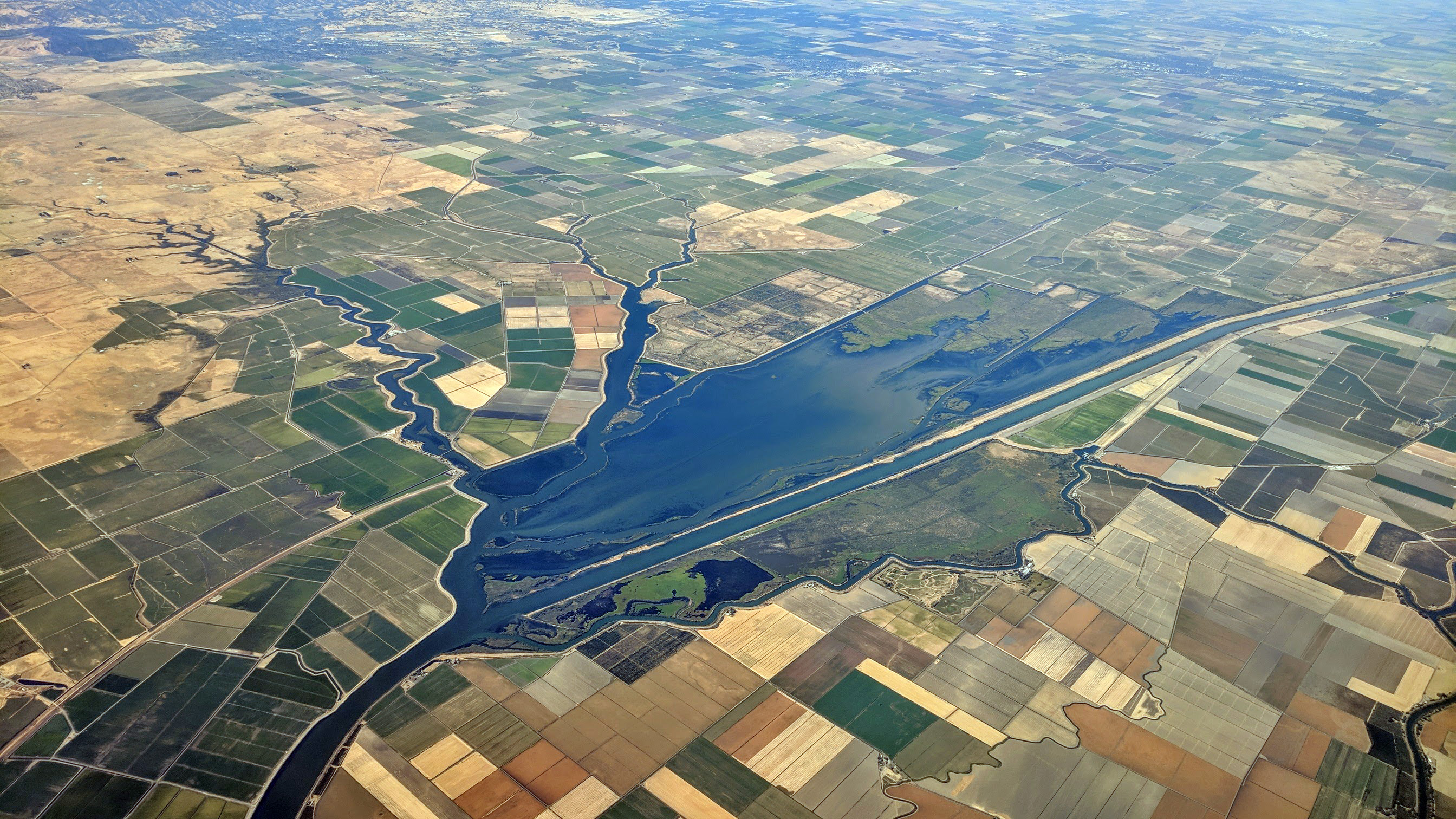
Rio Vista (Spanish: ''Río Vista'', meaning "River View") is a city located in the eastern end of Solano County, California, in the Sacramento River Delta region of Northern California. The population was 7,360 at the 2010 census. Geography Rio Vista is a small rural town approximately south of Sacramento, on the Sacramento River in the Sacramento River Delta. According to the United States Census Bureau, the city has a total area of , of which, of it is land and of it (5.68%) is water. Climate According to the Köppen Climate Classification system, Rio Vista has a warm-summer Mediterranean climate, abbreviated "Csa" on climate maps. History The present location of Rio Vista is several miles south of the original settlement. Colonel Nathan H. Davis founded "Brazos del Rio" near the entrance of Cache Slough at the Sacramento River, on the Rancho Los Ulpinos Mexican land grant, in 1858. The settlement was renamed "Rio Vista" before a flood in 1862 that resulted in the ... [...More Info...] [...Related Items...] OR: [Wikipedia] [Google] [Baidu] |
California State Route 84
State Route 84 (SR 84) is a state highway in the U.S. state of California that consists of two unconnected segments, one in the San Francisco Bay Area and the other primarily in the Sacramento–San Joaquin River Delta area. The first section is an east–west arterial road running from SR 1 in San Gregorio to Menlo Park, across the Dumbarton Bridge through Fremont and Newark and ending at I-580 in Livermore. The segment between Marsh Road and the Dumbarton Bridge has been upgraded to an expressway and is known as the Bayfront Expressway. The segment from the eastern end of the Dumbarton Bridge to the interchange with I-880 has been upgraded to a freeway. The other section is a north-south arterial road that begins at SR 12 in Rio Vista, passes through Ryer Island (where it connects to SR 220), and ends in West Sacramento. The Ryer Island Ferry provides the crossing over Cache Slough from Rio Vista to Ryer Island. The ferry is a diesel-powered boat operated by ... [...More Info...] [...Related Items...] OR: [Wikipedia] [Google] [Baidu] |
Sacramento River Delta
) , image_map = Sacramento County California Incorporated and Unincorporated areas Sacramento Highlighted.svg , mapsize = 250x200px , map_caption = Location within Sacramento County in California , pushpin_map = California#USA , pushpin_label = Sacramento , pushpin_map_caption = Location within California##Location in the United States , pushpin_relief = yes , coordinates = , coordinates_footnotes = , subdivision_type = Country , subdivision_name = United States , subdivision_type1 = State , subdivision_name1 = California , subdivision_type2 = County , subdivision_name2 = Sacramento ---- , subdivision_type3 = Region , subdivision_name3 = Sacramento Valley , subdivision_type4 = CSA , su ... [...More Info...] [...Related Items...] OR: [Wikipedia] [Google] [Baidu] |
Ryer Island
Ryer Island is an island in the Sacramento-San Joaquin River Delta surrounded by Miner Slough and Steamboat Slough at their confluence with the Sacramento River, 6.5 miles north-northeast of Rio Vista. It is in Solano County, California, and managed by Reclamation District 501. The island is named in honor of a California pioneer, Dr. Washington M. Ryer, and his family. A map prepared at the time of statehood shows the area divided by the west fork of the Sacramento River, with the western half identified as Priest Island and the eastern half identified as Sutter Island. The California Department of Transportation (Caltrans) operates two vehicle ferry services to the island, connecting the following state highways: * , towards Rio Vista * , towards Ryde Highway 220 then terminates at Highway 84 on Ryer Island, while the latter leaves the island north on a bridge, and towards West Sacramento. See also * List of islands of California * Ryer Island Ferry * Howard Landing Fe ... [...More Info...] [...Related Items...] OR: [Wikipedia] [Google] [Baidu] |
KGO-TV
KGO-TV (channel 7) is a television station licensed to San Francisco, California, United States, serving as the San Francisco Bay Area's ABC network outlet. Owned and operated by the network's ABC Owned Television Stations division, KGO-TV maintains studios at the ABC Broadcast Center immediately west of The Embarcadero north of the city's Financial District, and its transmitter is located atop Sutro Tower. In addition, KGO-TV leases part of its building to MyNetworkTV affiliate KRON-TV (channel 4, owned by Nexstar Media Group), but with completely separate operations. History KGO-TV first signed on the air on May 5, 1949, as the San Francisco Bay Area's second-oldest television station, signing on five months after KPIX (channel 5) and the 50th in the United States. In fact, KPIX had a hand in getting KGO-TV on the air, as the CBS-affiliated station produced informational programming on how to receive and view ABC's channel 7. KGO-TV's original studios were located in the ... [...More Info...] [...Related Items...] OR: [Wikipedia] [Google] [Baidu] |
San Francisco, California
San Francisco (; Spanish for "Saint Francis"), officially the City and County of San Francisco, is the commercial, financial, and cultural center of Northern California. The city proper is the fourth most populous in California and 17th most populous in the United States, with 815,201 residents as of 2021. It covers a land area of , at the end of the San Francisco Peninsula, making it the second most densely populated large U.S. city after New York City, and the fifth most densely populated U.S. county, behind only four of the five New York City boroughs. Among the 91 U.S. cities proper with over 250,000 residents, San Francisco was ranked first by per capita income (at $160,749) and sixth by aggregate income as of 2021. Colloquial nicknames for San Francisco include ''SF'', ''San Fran'', ''The '', ''Frisco'', and ''Baghdad by the Bay''. San Francisco and the surrounding San Francisco Bay Area are a global center of economic activity and the arts and sciences, spurred ... [...More Info...] [...Related Items...] OR: [Wikipedia] [Google] [Baidu] |
Real McCoy II
The ''Real McCoy II'' is a ferryboat that has operated since 2011 from Rio Vista, California on the Ryer Island Ferry route as part of California State Route 84, operated by the California Department of Transportation. It replaced the original ''Real McCoy'' in 2011. It operates 24 hours per day, 7 days per week, three trips per hour, over the 800 foot gap in California State Route 84 in the Sacramento River delta, between Ryer Island Ryer Island is an island in the Sacramento-San Joaquin River Delta surrounded by Miner Slough and Steamboat Slough at their confluence with the Sacramento River, 6.5 miles north-northeast of Rio Vista. It is in Solano County, California, and ... and Rio Vista. ''Real McCoy II'' is 88 feet long by 38 feet wide, has a capacity of 80,000 pounds, and can carry up to ten vehicles. There is a 16.25-ton weight limit, tractor-trailers are prohibited, and the length limit is at the discretion of the Coast Guard. Notes Ferries on the California h ... [...More Info...] [...Related Items...] OR: [Wikipedia] [Google] [Baidu] |
Ferries On The California Highway System
A ferry is a ship, watercraft or amphibious vehicle used to carry passengers, and sometimes vehicles and cargo, across a body of water. A passenger ferry with many stops, such as in Venice, Italy, is sometimes called a water bus or water taxi. Ferries form a part of the public transport systems of many waterside cities and islands, allowing direct transit between points at a capital cost much lower than bridges or tunnels. Ship connections of much larger distances (such as over long distances in water bodies like the Mediterranean Sea) may also be called ferry services, and many carry vehicles. History In ancient times The profession of the ferryman is embodied in Greek mythology in Charon, the boatman who transported souls across the River Styx to the Underworld. Speculation that a pair of oxen propelled a ship having a water wheel can be found in 4th century Roman literature "''Anonymus De Rebus Bellicis''". Though impractical, there is no reason why it could not w ... [...More Info...] [...Related Items...] OR: [Wikipedia] [Google] [Baidu] |
Steamships Of The United States
A steamship, often referred to as a steamer, is a type of steam-powered vessel, typically ocean-faring and seaworthy, that is propelled by one or more steam engines that typically move (turn) propellers or paddlewheels. The first steamships came into practical usage during the early 1800s; however, there were exceptions that came before. Steamships usually use the prefix designations of "PS" for ''paddle steamer'' or "SS" for ''screw steamer'' (using a propeller or screw). As paddle steamers became less common, "SS" is assumed by many to stand for "steamship". Ships powered by internal combustion engines use a prefix such as "MV" for ''motor vessel'', so it is not correct to use "SS" for most modern vessels. As steamships were less dependent on wind patterns, new trade routes opened up. The steamship has been described as a "major driver of the first wave of trade globalization (1870–1913)" and contributor to "an increase in international trade that was unprecedented in hum ... [...More Info...] [...Related Items...] OR: [Wikipedia] [Google] [Baidu] |


.jpg)


