|
Reach Out Worldwide
Reach Out Worldwide is a 501(c)(3) registered nonprofit founded in 2010 by Paul Walker that helps bring first responders to disaster areas to augment local relief efforts. Their teams typically consist of medical technicians, doctors, nurses, paramedics, firefighters, and construction workers. The group's goal is to air-drop into disaster zones the minute the news hits the wires. Paul Walker's brother, Cody Walker, is the current Chief Executive Officer of Reach Out Worldwide. Paul Walker organized a relief team in response to the 2010 Haiti earthquake, and, following their return, he founded Reach Out Worldwide to help fill the gap between available resources and the requirement for personnel in post-disaster situations. Reach Out Worldwide's work is mainly the result of volunteers that focus on quick deployments to areas that are small or remote and are often the first assistance a town or village sees. Domestically, they assist with clean up efforts ranging from mucking and gut ... [...More Info...] [...Related Items...] OR: [Wikipedia] [Google] [Baidu] |
Paul Walker
Paul William Walker IV (September 12, 1973 – November 30, 2013) was an American actor. He was known for his role as Brian O'Conner in the ''Fast & Furious'' franchise. Walker began his career as a child actor in the 1980s, gaining recognition in the 1990s after appearing in the television soap opera ''The Young and the Restless''; he received praise for his performances in the teen comedy '' She's All That'' and the comedy-drama '' Varsity Blues'' (both 1999), and saw international fame by starring in ''The Fast and the Furious'' (2001). Walker also starred in the commercially successful road thriller '' Joy Ride'' (2001), becoming an action star. He followed this with the box-office disappointments '' Into the Blue'' (2005) and '' Running Scared'' (2006), although he earned praise for his performance in the survival drama '' Eight Below'', and for his portrayal of Hank Hansen in '' Flags of Our Fathers'' (both 2006). Outside of these, Walker largely appeared in low budget ... [...More Info...] [...Related Items...] OR: [Wikipedia] [Google] [Baidu] |
October 2015 North American Storm Complex
The October 2015 North American storm complex was an extratropical storm that triggered a high precipitation event, which caused historic flash flooding across North and South Carolina. The incipient cold front traversed the Eastern United States on September 29–30, producing heavy rain in multiple states. The system subsequently stalled just offshore. Tapping into moisture from the nearby Hurricane Joaquin, a developing surface low brought heavy, continuous rain to southeastern States, with the worst effects concentrated in South Carolina where catastrophic flooding occurred. The event culminated in South Carolina on October 4 when numerous rivers burst their banks, washing away roads, bridges, vehicles, and homes. Hundreds of people required rescue and the state's emergency management department urged everyone in the state not to travel. Some areas of the state saw rainfall equivalent to a 1-in-1000-year event. At least 25 deaths have been attributed to t ... [...More Info...] [...Related Items...] OR: [Wikipedia] [Google] [Baidu] |
2010 Chile Earthquake
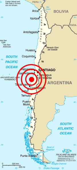
The 2010 Chile earthquake and tsunami ( es, Terremoto del 27F) occurred off the coast of central Chile on Saturday, 27 February at 03:34 local time (06:34 UTC), having a magnitude of 8.8 on the moment magnitude scale, with intense shaking lasting for about three minutes. It was felt strongly in six Chilean regions (from Valparaíso in the north to Araucanía in the south) that together make up about 80 percent of the country's population. According to the United States Geological Survey (USGS) the cities experiencing the strongest shaking—VIII (''Severe'') on the Mercalli intensity scale (MM)—were Concepción, Arauco, and Coronel. According to Chile's Seismological Service, Concepción experienced the strongest shaking at MM IX (''Violent''). The earthquake was felt in the capital Santiago at MM VII (''Very strong'') or MM VIII. Tremors were felt in many Argentine cities, including Buenos Aires, Córdoba, Mendoza, and La Rioja. Tremors were felt as far north as th ... [...More Info...] [...Related Items...] OR: [Wikipedia] [Google] [Baidu] |
2010 Mentawai Earthquake And Tsunami
The 2010 Mentawai earthquake occurred with a moment magnitude of 7.8 on 25 October off the western coast of Sumatra at 21:42 local time (14:42 UTC). The earthquake occurred on the same fault that produced the 2004 Indian Ocean earthquake. It was widely felt across the provinces of Bengkulu and West Sumatra and resulted in a substantial localized tsunami that struck the Mentawai Islands. Tectonic setting The island of Sumatra lies above the Sunda megathrust, the interface between the subducting Australian Plate and the overriding Sunda Plate. Movement on this structure has been responsible for many large historical megathrust earthquakes. The most recent sequence of large ruptures started with the 2004 Indian Ocean earthquake and included the 2005 Nias–Simeulue earthquake and the 2007 Sumatra earthquakes. Earthquake The earthquake occurred around west of Bengkulu, close to the Mentawai Islands, southwest of South Pagai. The USGS first reported the hypocenter of t ... [...More Info...] [...Related Items...] OR: [Wikipedia] [Google] [Baidu] |
Tropical Storm Washi
Severe Tropical Storm Washi, known in the Philippines as Tropical Storm Sendong, was a late-season tropical cyclone that caused around 1,200 to 1,500 deaths and catastrophic damage in the Philippines in late 2011. Washi made landfall over Mindanao, a major region in the Philippines, on December 16. Washi weakened slightly after passing Mindanao, but regained strength in the Sulu Sea, and made landfall again over Palawan on December 17. Meteorological history On December 12, the Joint Typhoon Warning Center (JTWC) noted that a developing area of low pressure had persisted about 945 km (585 mi) south-southeast of Guam. Situated along the southern edge of a subtropical ridge, the system tracked steadily westward towards the Philippines. Located within a region of good diffluence and moderate wind shear, deep convection was able to maintain itself over the circulation. Development of banding features and improvement of outflow indicated strengthening wa ... [...More Info...] [...Related Items...] OR: [Wikipedia] [Google] [Baidu] |
2013 El Reno Tornado
During the early evening of Friday, May 31, 2013, a very large and powerful tornado occurred over rural areas of Central Oklahoma. This rain-wrapped, multiple-vortex tornado was the widest tornado ever recorded and was part of a larger weather system that produced dozens of tornadoes over the preceding days. The tornado initially touched down at 6:03 p.m. Central Daylight Time (2303 UTC) about west-southwest of El Reno, rapidly growing in size and becoming more violent as it tracked through central portions of Canadian County. Remaining over mostly open terrain, the tornado did not impact many structures; however, measurements from mobile weather radars revealed extreme winds up to within the vortex. These are among the highest observed wind speeds on Earth, just slightly lower than the wind speeds of the 1999 Bridge Creek–Moore tornado. As it crossed U.S. 81, it had grown to a record-breaking width of , beating the previous width record held by the 200 ... [...More Info...] [...Related Items...] OR: [Wikipedia] [Google] [Baidu] |
2013 Colorado Floods
The 2013 Colorado floods were a series of natural disasters occurring in the U.S. state of Colorado. Starting on September 11, 2013, a slow-moving cold front stalled over Colorado, clashing with warm humid monsoonal air from the south. This resulted in heavy rain and catastrophic flooding along Colorado's Front Range from Colorado Springs north to Fort Collins. The situation intensified on September 11 and 12. Boulder County was worst hit, with recorded September 12 and up to of rain recorded by September 15, which is comparable to Boulder County's average annual precipitation (20.7 inches, 525 mm). This event has also been referred to as the 2013 Colorado Front Range Flood, reflecting a more precise geographic extent in and along the Colorado Front Range mountains. The National Weather Service's Hydrometeorological Design Studies Center stated in a document that the annual exceedance probability (AEP) for the entire rainfall event was as low as 1/1000 (0.1%) in places. ... [...More Info...] [...Related Items...] OR: [Wikipedia] [Google] [Baidu] |
Tornado Outbreak Of November 17, 2013
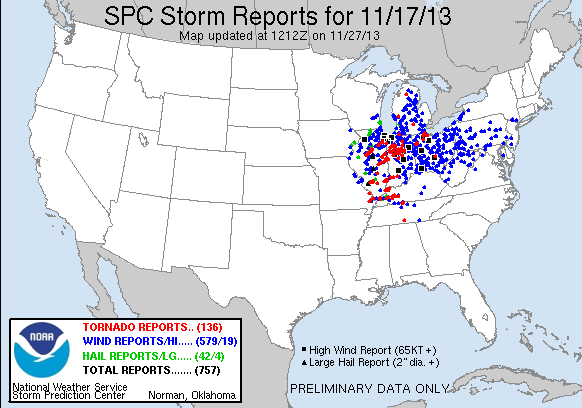
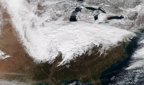
On November 17, 2013, the deadliest and costliest November tornado outbreak in Illinois history took shape, becoming the fourth-largest for the state overall. With more than 30 tornadoes in Indiana, it was that state's largest tornado outbreak for the month of November, and the second largest outbreak recorded in Indiana. Associated with a strong trough in the upper levels of the atmosphere, the event resulted in 77 tornadoes tracking across regions of the Midwest United States and Ohio River Valley, impacting seven states. Severe weather during the tornado outbreak caused over 100 injuries and eleven fatalities, of which eight were tornado related. Two tornadoes—both in Illinois and rated EF4 on the Enhanced Fujita Scale—were the strongest documented during the outbreak and combined for five deaths. In addition to tornadoes, the system associated with the outbreak produced sizeable hail peaking at in diameter in Bloomington, Illinois, as well as damaging winds estim ... [...More Info...] [...Related Items...] OR: [Wikipedia] [Google] [Baidu] |
Typhoon Haiyan
Typhoon Haiyan, known in the Philippines as Super Typhoon Yolanda, was one of the most powerful tropical cyclones ever recorded. On making landfall, Haiyan devastated portions of Southeast Asia, particularly the Philippines. It is one of the deadliest Philippine typhoons on record, killing at least 6,300 people in that country alone. In terms of JTWC-estimated 1-minute sustained winds, Haiyan is tied with Meranti in 2016 for being the second strongest landfalling tropical cyclone on record, only behind Goni of 2020. As of January 2014, bodies were still being found. Haiyan was also the most intense tropical cyclone worldwide in 2013. This typhoon is also the second deadliest typhoon in the Philippines. The 30th named storm, thirteenth typhoon, and fifth super typhoon of the 2013 Pacific typhoon season, Haiyan originated from an area of low pressure several hundred kilometers east-southeast of Pohnpei in the Federated States of Micronesia on November 2, 2013. Tracking ... [...More Info...] [...Related Items...] OR: [Wikipedia] [Google] [Baidu] |
Typhoon Yolanda
Typhoon Haiyan, known in the Philippines as Super Typhoon Yolanda, was one of List of the most intense tropical cyclones, the most powerful tropical cyclones ever recorded. On making landfall, Haiyan devastated portions of Southeast Asia, particularly the Philippines. It is one of the deadliest Typhoons in the Philippines, Philippine typhoons on record, killing at least 6,300 people in that country alone. In terms of JTWC-estimated 1-minute sustained winds, Haiyan is tied with Typhoon Meranti, Meranti in 2016 Pacific typhoon season, 2016 for being the second strongest landfall (meteorology), landfalling tropical cyclone on record, only behind Typhoon Goni, Goni of 2020 Pacific typhoon season, 2020. As of January 2014, bodies were still being found. Haiyan was also the most intense tropical cyclone Tropical cyclones in 2013, worldwide in 2013. This typhoon is also the second deadliest typhoon in the Philippines. The 30th Tropical cyclone naming, named storm, thirteenth typhoon, ... [...More Info...] [...Related Items...] OR: [Wikipedia] [Google] [Baidu] |
Tornado Outbreak Of April 27–30, 2014
A relatively widespread, damaging, and deadly tornado outbreak struck the central and southern United States in late April 2014. The storm complex responsible for the outbreak produced multiple long-track tornadoes – seven were deadly, causing 35 fatalities.U.S. tornadoes kill 35 over 2 days (via the ), April 29, 2014. One additional death occurred in , due to severe flooding associated with this system. ... [...More Info...] [...Related Items...] OR: [Wikipedia] [Google] [Baidu] |
January 2015 North American Blizzard
The January 2015 North American blizzard was a powerful and severe blizzard that dumped up to of snowfall in parts of New England. Originating from a disturbance just off the coast of the Northwestern United States on January 23, it initially produced a light swath of snow as it traveled southeastwards into the Midwest as an Alberta clipper on January 24–25. It gradually weakened as it moved eastwards towards the Atlantic Ocean, however, a new dominant low formed off the East Coast of the United States late on January 26, and rapidly deepened as it moved northeastwards towards southeastern New England, producing pronounced blizzard conditions. The nor’easter then gradually weakened as it moved away into Canada. The storm was also given unofficial names, such as ''Blizzard of 2015'', and ''Winter Storm Juno''. The nor'easter disrupted transportation, with snow emergencies declared in six states and travel bans enacted in four of these states – Connecticut, New Jersey, Massac ... [...More Info...] [...Related Items...] OR: [Wikipedia] [Google] [Baidu] |


