|
Rama Deva Raya
Rama Deva Raya (or Vira Rama Deva Raya) (reigned 1617–1632) ascended the throne after a gruesome war in 1617 as the Emperor of Vijaynagara. In 1614, his father Sriranga II, who was the preceding emperor, and his family were murdered by rival factions headed by Jagga Raya, who was one of their kins. Rama Deva himself was smuggled out of the prison by Yachama Naidu, a faithful commander and the viceroy of earlier emperor Venkata II. Civil War Jagga Raya made a claim of a putative son of Venkata II's queens as the King, which was strongly challenged by Yachama Naidu, the leading general in the imperial army and the Nayak of Kalahasti, who claimed the throne for Rama Deva, the rightful heir. In a long-drawn battle between the two factions in which the whole of the kingdom took part, Jagga Raya would be slain and his Gobburi estates in south west of Nellore in present-day Chennai, Chengelpet seized by Yachama Naidu. Battle of Toppur The defeated Jagga Raya sought refuge in ... [...More Info...] [...Related Items...] OR: [Wikipedia] [Google] [Baidu] |
Emperor Of Vijayanagara
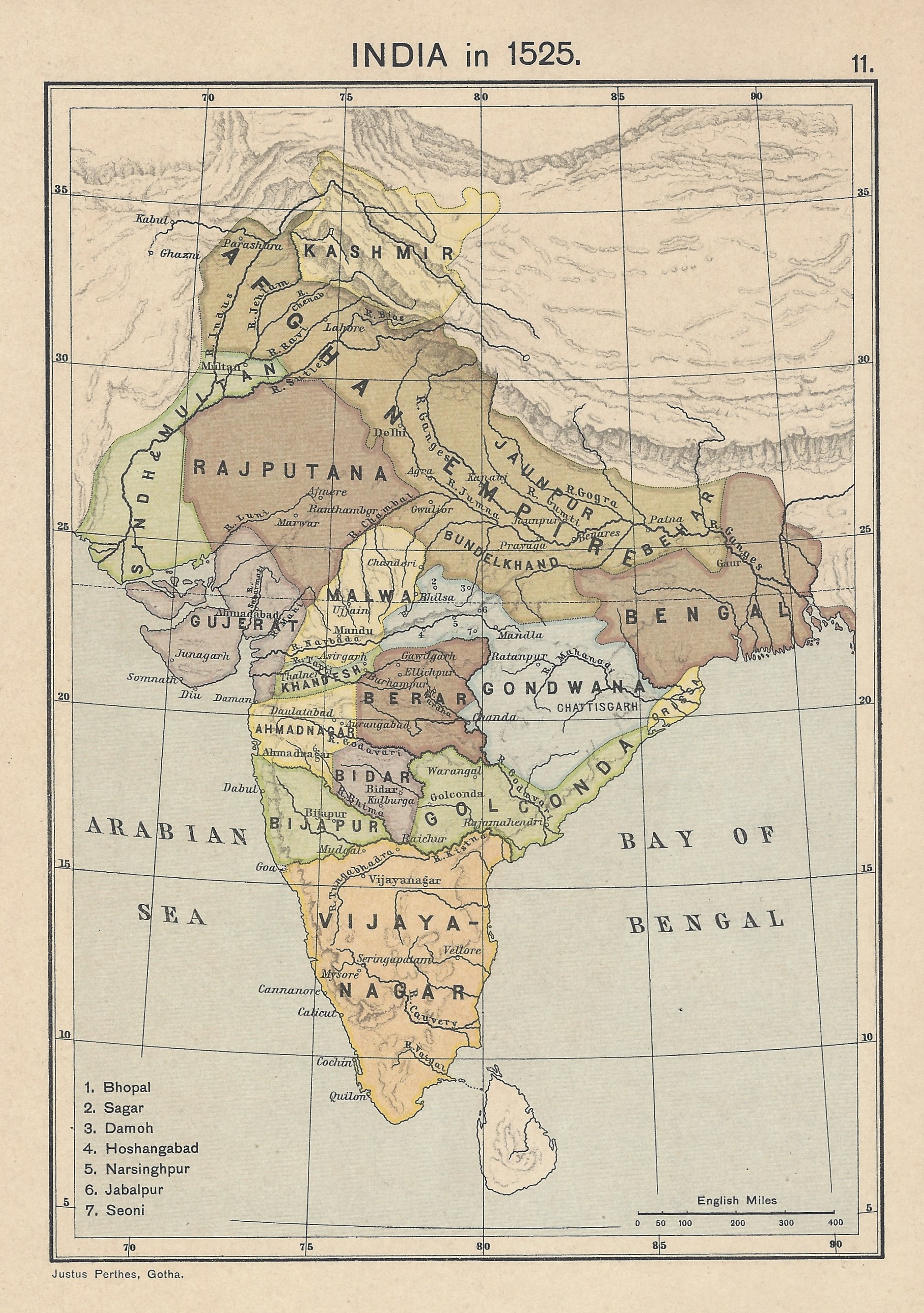
The Vijayanagara Empire (1336–1646) was the most prominent medieval India, medieval List of Hindu empires and dynasties, Hindu empire of southern India. It was established on the banks of Tungabhadra River in present-day Karnataka and consisted of parts or all of the modern states of Karnataka, Andhra Pradesh, Tamil Nadu, Kerala, Goa and some parts of Telangana, Maharashtra and Sri Lanka. The Vijayanagara Empire was established in 1336 by the brothers Harihara I and Bukka Raya I of the Sangama dynasty. Under the rule of Krishnadevaraya, the empire reached its peak. The empire lasted until 1646, although its power greatly declined after a major military defeat in the Battle of Talikota in 1565 by the combined armies of the Deccan sultanates. Family trees Sangama dynasty Saluva dynasty Tuluva dynasty Aravidu dynasty List of Emperors Vijayanagara Empire (1336–16 ... [...More Info...] [...Related Items...] OR: [Wikipedia] [Google] [Baidu] |
Gingee
Gingee, also known as Senji or Jinji and originally called Singapuri, is a panchayat town in Viluppuram district in the Indian state of Tamil Nadu. Gingee is located between three hills covering a perimeter of 3 km, and lies west of the Sankaraparani River. History The founding of the Kon dynasty established Gingee Fort as a fortified royal center. The Gingee country then came under the rule of the Hoysalas in the later part of the 13th and in the first half of the 14th century. From the Hoysalas, it passed to the first rulers of the Vijayanagara empire. The imperial Vijayanagara dominion gradually expanded over Southern India and divided the administration of the tamil country into three important provinces, which were assigned to the Nayaks. These were the Nayaks of Madurai, Nayaks of Tanjore, and Nayaks of Gingee. Information about the Gingee Nayaks and their rule is very scant. It is said that Tupakula Krishnappa Nayaka (1490 to 1521) of a Chandragiri family w ... [...More Info...] [...Related Items...] OR: [Wikipedia] [Google] [Baidu] |
Tanjore
Thanjavur (), also known as Thanjai, previously known as Tanjore,#Pletcher, Pletcher 2010, p. 195 is a city in the India, Indian state of Tamil Nadu. It is the 12th biggest city in Tamil Nadu. Thanjavur is an important center of South Indian culture, southern Indian religion, art, and architecture. Most of the Great Living Chola Temples, which are World Heritage Sites, UNESCO World Heritage Monuments, are located in and around Thanjavur. The foremost among these, the Brihadisvara Temple, built by the Chola emperor Rajaraja I, is located in the centre of the city. This temple has one of the largest bull statues (called Nandi) in India carved out of a single granite rock. Thanjavur is also home to Thanjavur painting, Tanjore painting, a painting style unique to the region. Thanjavur is the headquarters of the Thanjavur district, Thanjavur District. The city is an important agricultural centre located in the Cauvery Delta, Kaveri Delta and is known as the ''Rice bowl of Tamil Nadu' ... [...More Info...] [...Related Items...] OR: [Wikipedia] [Google] [Baidu] |
Kurnool
Kurnool is a city in the state of Andhra Pradesh, India. It formerly served as the capital of Andhra State (1953–1956). The city is often referred to as "The Gateway of Rayalaseema". Kurnool is also famous for Diamond hunting as diamonds can be found in the barren land of Kurnool after the top layers of soil are washed away by the monsoon rains. It also serves as the district headquarters of its Kurnool district. census, it is the fifth most populous city in the state with a population of 425,214. It is located on the banks of the Tungabhadra river. Although the area has been inhabited for thousands of years, modern Kurnool was founded in the 16th century CE with the construction of the Konda Reddy Fort. Etymology The original name of Kurnool is found in historical records as ''Kandanavōlu'' or ''Kandanōlu''. It used to be a crossing on the Tungabhadra River, where the bullock cart caravans are believed to have greased their wheels ("''kandana''" being a reference ... [...More Info...] [...Related Items...] OR: [Wikipedia] [Google] [Baidu] |
Bijapur Sultan
The Sultanate of Bijapur was an early modern kingdom in the western Deccan and South India, ruled by the Muslim Adil Shahi (or Adilshahi) dynasty. Bijapur had been a ''taraf'' (province) of the Bahmani Kingdom prior to its independence in 1490 and before the kingdom's political decline in the last quarter of the 15th century. It was one of the Deccan sultanates, the collective name of the kingdom's five successor states. The Sultanate of Bijapur was one of the most powerful states on the Indian Subcontinent at its peak, second to the Mughal Empire which conquered it in 1686 under Aurangzeb. After emigrating to the Bahmani Sultanate, Yusuf Adil Shah rose through the ranks to be appointed governor of the province of Bijapur. In 1490, he created a ''de facto'' independent Bijapur state which became formally independent with the Bahmani collapse in 1518. The Bijapur Sultanate's borders changed considerably throughout its history. Its northern boundary remained relatively stable, st ... [...More Info...] [...Related Items...] OR: [Wikipedia] [Google] [Baidu] |
Thanjavur Nayak
The Thanjavur Nayak dynasty (or Thanjavur Nayak kingdom) were the rulers of Thanjavur in the 15th and 17th centuries founded by Sevappa Nayak, Sevappa Nayaka. The Nayaks, who were Telugu people, Telugu Balija, Balijas,* * * * * * * * * were originally appointed as provincial governors by the Vijayanagara Empire, Vijayanagara Emperor in the 15th century, who divided the territory into Nayak kingdoms which were Madurai Nayak dynasty, Madurai, Thanjavur and Nayaks of Gingee, Gingee. In the mid-15th century they became an independent kingdom, although they continued their alliance with the Vijayanagara Empire. The Thanjavur Nayaks were notable for their patronage of literature and the arts. Origins of Nayak rule With the end of the Imperial Cholas, Chola Empire in 1279, Thanjavur was ruled by a branch of Chola dynasty, until the Vijayanagara Empire conquered all of South India, southern India by the late 14th century. In 1532 CE, Achyuta Deva Raya, the brother and successo ... [...More Info...] [...Related Items...] OR: [Wikipedia] [Google] [Baidu] |
Gingee Fort
Gingee Fort or Senji Fort (also known as Chenji, Chanchi, Jinji or Senchi) in Tamil Nadu, India is one of the surviving forts in Tamil Nadu, India. It is popularly known as Great Wall of South India. It lies in Villupuram District, from the state capital, Chennai, and is close to the Union Territory of Puducherry (union territory), Puducherry. The site is so fortified that Chhatrapati Shivaji Maharaj, the Maratha king, ranked it as the "most impregnable fortress in India", and it was called the "Troy of the East" by the United Kingdom, British. Originally built by Ananta Kon around 1190 AD and later fortified by Krishna Kon, it was later modified in the 13th century to elevate it to the status of an unbreachable citadel to protect the town of Gingee by Kurumba Gounder, kottailinga kurumbar king. It was also the headquarters domination in northern Tamil Nadu. The fort was built as a strategic place of fending off any invading armies. As per one account, the fort was further fort ... [...More Info...] [...Related Items...] OR: [Wikipedia] [Google] [Baidu] |
Grand Anicut
Kallanai (also known as the Grand Anicut) is an ancient dam built by Karikala of Chola dynasty in 150 CE. It was built (in running water) across the Kaveri river flowing from Tiruchirapalli District to Thanjavur district, Tamil Nadu, India. The dam is located in Thanjavur district,https://tngis.tnega.org/generic_viewer/ 15 km from Tiruchirapalli and 45 km from Thanjavur. It is the fourth oldest water-diversion or water-regulator structure in the world and the oldest in India that is still in use. Because of its spectacular architecture, it is one of the prime tourist spots in Tamil Nadu. History The dam was originally built by King Karikalan of the Chola Dynasty in . It is located on the river in Thanjavur district, exactly 14 km from the city of Tiruchirappalli and 45 km from the city of Thanjavur. The idea behind the construction of the dam was to divert the river to the delta districts thereby boosting irrigation. This dam was re-modeled by the British ... [...More Info...] [...Related Items...] OR: [Wikipedia] [Google] [Baidu] |
Cauvery
The Kaveri (also known as Cauvery) is a major river flowing across Southern India. It is the third largest river in the region after Godavari and Krishna. The catchment area of the Kaveri basin is estimated to be and encompasses the states of Tamil Nadu, Karnataka, Kerala, and the union territory of Puducherry. The river rises at Talakaveri in the Brahmagiri range in the Western Ghats. The source is located at an elevation of in the Kodagu district of Karnataka. The river flows for about through the Deccan plateau in Karnataka before entering Tamil Nadu. It flows further eastward in Tamil Nadu for before flowing into the Bay of Bengal near Poompuhar in Mayiladuthurai district of Tamil Nadu. The river flows for a total length of about . The major tributaries include Amaravati, Arkavati, Bhavani, Hemavati, Kabini, Lakshmana Tirtha, and Noyyal. There are a number of dams on the river which form part of an extensive irrigation system and are used for the generation ... [...More Info...] [...Related Items...] OR: [Wikipedia] [Google] [Baidu] |
Jaffna
Jaffna (, ; , ) is the capital city of the Northern Province, Sri Lanka, Northern Province of Sri Lanka. It is the administrative headquarters of the Jaffna District located on a Jaffna Peninsula, peninsula of the same name. With a population of 88,138 in 2012, Jaffna is Sri Lanka's 12th List of cities in Sri Lanka, most populous city. Jaffna is approximately from Kandarodai which served as an Marketplace, emporium in the Jaffna peninsula from classical antiquity. Jaffna's suburb Nallur, Jaffna, Nallur served as the capital of the four-century-long medieval Tamil Jaffna Kingdom. Prior to the Sri Lankan civil war, Sri Lankan Civil War, it was Sri Lanka's second most populous city after Colombo. The 1980s insurgent uprising led to extensive damage, expulsion of part of the population, and military occupation. Since the end of civil war in 2009, refugees and internally displaced people began returning to homes, while government and private sector reconstruction started taking plac ... [...More Info...] [...Related Items...] OR: [Wikipedia] [Google] [Baidu] |
Karnataka
Karnataka ( ) is a States and union territories of India, state in the southwestern region of India. It was Unification of Karnataka, formed as Mysore State on 1 November 1956, with the passage of the States Reorganisation Act, 1956, States Reorganisation Act, and renamed ''Karnataka'' in 1973. The state is bordered by the Lakshadweep Sea to the west, Goa to the northwest, Maharashtra to the north, Telangana to the northeast, Andhra Pradesh to the east, Tamil Nadu to the southeast, and Kerala to the southwest. With 61,130,704 inhabitants at the 2011 census, Karnataka is the List of states and union territories of India by population, eighth-largest state by population, comprising 31 List of districts in India, districts. With 15,257,000 residents, the state capital Bengaluru is the largest city of Karnataka. The economy of Karnataka is among the most productive in the country with a gross state domestic product (GSDP) of and a per capita GSDP of for the financial year 2023– ... [...More Info...] [...Related Items...] OR: [Wikipedia] [Google] [Baidu] |
Vellore
Vellore ( ), also spelled Velur, is a sprawling city and the administrative headquarters of Vellore district in the Indian state of Tamil Nadu. It is located on the banks of the Palar River and surrounded by the Javadi Hills in the northeastern part of Tamil Nadu and is separated into four zones that are further subdivided into 60 wards, covering an area of 153.14 km2 and housing a population of 315,128 as reported by the 2011 census. The Vellore city along with its sub urban areas is spread across approximately 200 km² with a population of 484,690 as of 2011. It is located about west of Chennai, and about east of Bangalore. Vellore is located on the Mumbai–Chennai arm of the Golden Quadrilateral. Vellore is governed under a mayor and the Vellore Municipal Corporation. It is a part of both the Vellore (Lok Sabha constituency), Lok Sabha and Vellore (State Assembly Constituency), state assembly constituencies of Vellore. Vellore is the home to the Christian Medic ... [...More Info...] [...Related Items...] OR: [Wikipedia] [Google] [Baidu] |


