|
Ralaghan
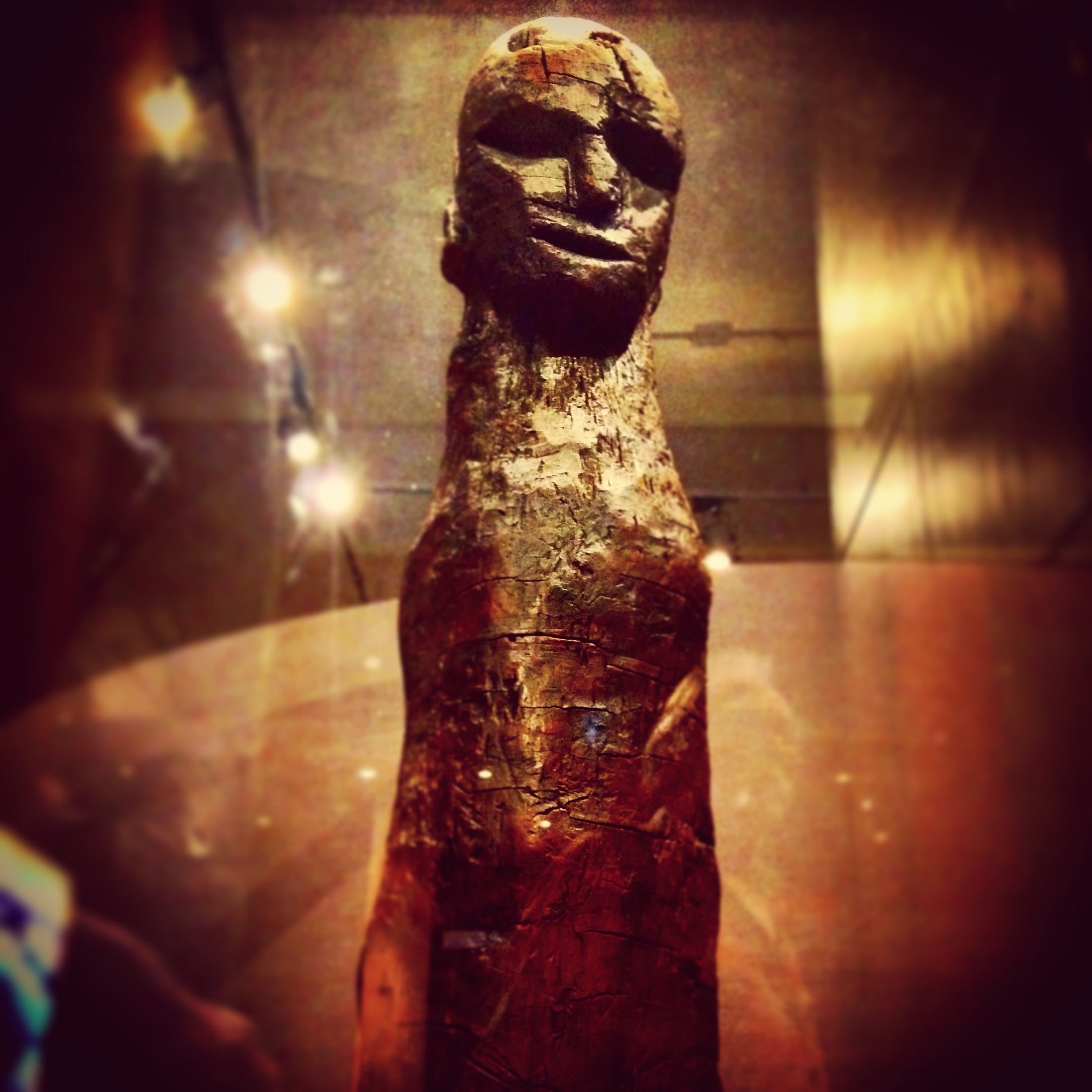
Ralaghan is a townland located outside Shercock, County Cavan in Ireland. Ralaghan Man In 1908 a rare, carved anthropomorphic figure, which has been named Ralaghan Man The Ralaghan idol, also known as the "Ralaghan figure", is a late Bronze Age anthropomorphic, carved wooden figure found in a bog in the townland of Ralaghan, County Cavan, Ireland. It is held by the National Museum of Ireland. A sample of wood f ..., was uncovered at the bog of Ralaghan. Townlands of County Cavan {{Cavan-geo-stub ... [...More Info...] [...Related Items...] OR: [Wikipedia] [Google] [Baidu] |
Ralaghan Man
The Ralaghan idol, also known as the "Ralaghan figure", is a late Bronze Age anthropomorphic, carved wooden figure found in a bog in the townland of Ralaghan, County Cavan, Ireland. It is held by the National Museum of Ireland. A sample of wood from the figure yielded a Radiocarbon date (OxA–1719) of 1096–906 cal. BC.Waddell (1998), p.233 Discovery The figure was found during turf cutting in a small peat bog close to the townland boundary between Ralaghan and Crossmakeelan, in the civil parish of Shercock, County Cavan, Ireland. Its discovery was announced in 1930 in the journal ''Antiquity'' by Adolf Mahr, keeper of Irish Antiquities in the National Museum in Dublin. Mahr reported that the figure was found face down "''under 3 to 4 feet of peat in an area of bog that had been "reclaimed since". No associated archaeological structures were reported, and Mahr reported that no other finds were retrieved from the bog. Description The figure is 113.5cm long and made from yew (' ... [...More Info...] [...Related Items...] OR: [Wikipedia] [Google] [Baidu] |
County Cavan
County Cavan ( ; gle, Contae an Chabháin) is a county in Ireland. It is in the province of Ulster and is part of the Border Region. It is named after the town of Cavan and is based on the historic Gaelic territory of East Breffny (''Bréifne''). Cavan County Council is the local authority for the county, which had a population of 76,176 at the 2016 census. Geography Cavan borders six counties: Leitrim to the west, Fermanagh and Monaghan to the north, Meath to the south-east, Longford to the south-west and Westmeath to the south. Cavan shares a border with County Fermanagh in Northern Ireland. Cavan is the 19th largest of the 32 counties in area and the 25th largest by population. The county is part of the Northern and Western Region, a NUTS II area, and in that region, is part of the Border strategic planning area, a NUTS III entity. The county is characterised by drumlin countryside dotted with many lakes and hills. The north-western area of the county is spar ... [...More Info...] [...Related Items...] OR: [Wikipedia] [Google] [Baidu] |
Shercock
Shercock ( ); ) is a small town situated in the east of County Cavan, Ireland. As of the 2016 census, the population of the town was 588. Shercock is located at the intersection of the R162 and R178 regional roads. It sits on the shores of three lakes: Lough Sillan, Steepleton's Lake, and Muddy Lake. Lough Sillan is the largest of the three, covering approximately 162 hectares. History The town was founded in the early seventeenth century as a plantation village to accommodate mainly Presbyterian Scottish settlers who were planted in this part of County Cavan. Usually, these planters gave their new settlements English or Scottish names—the neighbouring towns are Kingscourt, Cootehill, and Bailieborough—but Shercock retained its Irish name. The modern Irish-language name is ''Searcoig'' or ''Searcóg''. Nearly all of the surrounding townlands have kept their Gaelic names. For example, the townland of Lecks, on the Kingscourt road on the outskirts of Shercock, has been ... [...More Info...] [...Related Items...] OR: [Wikipedia] [Google] [Baidu] |
Townland
A townland ( ga, baile fearainn; Ulster-Scots: ''toonlann'') is a small geographical division of land, historically and currently used in Ireland and in the Western Isles in Scotland, typically covering . The townland system is of Gaelic origin, pre-dating the Norman invasion, and most have names of Irish origin. However, some townland names and boundaries come from Norman manors, plantation divisions, or later creations of the Ordnance Survey.Connolly, S. J., ''The Oxford Companion to Irish History, page 577. Oxford University Press, 2002. ''Maxwell, Ian, ''How to Trace Your Irish Ancestors'', page 16. howtobooks, 2009. The total number of inhabited townlands in Ireland was 60,679 in 1911. The total number recognised by the Irish Place Names database as of 2014 was 61,098, including uninhabited townlands, mainly small islands. Background In Ireland a townland is generally the smallest administrative division of land, though a few large townlands are further divided into ... [...More Info...] [...Related Items...] OR: [Wikipedia] [Google] [Baidu] |
Ireland
Ireland ( ; ga, Éire ; Ulster Scots dialect, Ulster-Scots: ) is an island in the Atlantic Ocean, North Atlantic Ocean, in Northwestern Europe, north-western Europe. It is separated from Great Britain to its east by the North Channel (Great Britain and Ireland), North Channel, the Irish Sea, and St George's Channel. Ireland is the List of islands of the British Isles, second-largest island of the British Isles, the List of European islands by area, third-largest in Europe, and the List of islands by area, twentieth-largest on Earth. Geopolitically, Ireland is divided between the Republic of Ireland (officially Names of the Irish state, named Ireland), which covers five-sixths of the island, and Northern Ireland, which is part of the United Kingdom. As of 2022, the Irish population analysis, population of the entire island is just over 7 million, with 5.1 million living in the Republic of Ireland and 1.9 million in Northern Ireland, ranking it the List of European islan ... [...More Info...] [...Related Items...] OR: [Wikipedia] [Google] [Baidu] |


