|
Radyvyliv
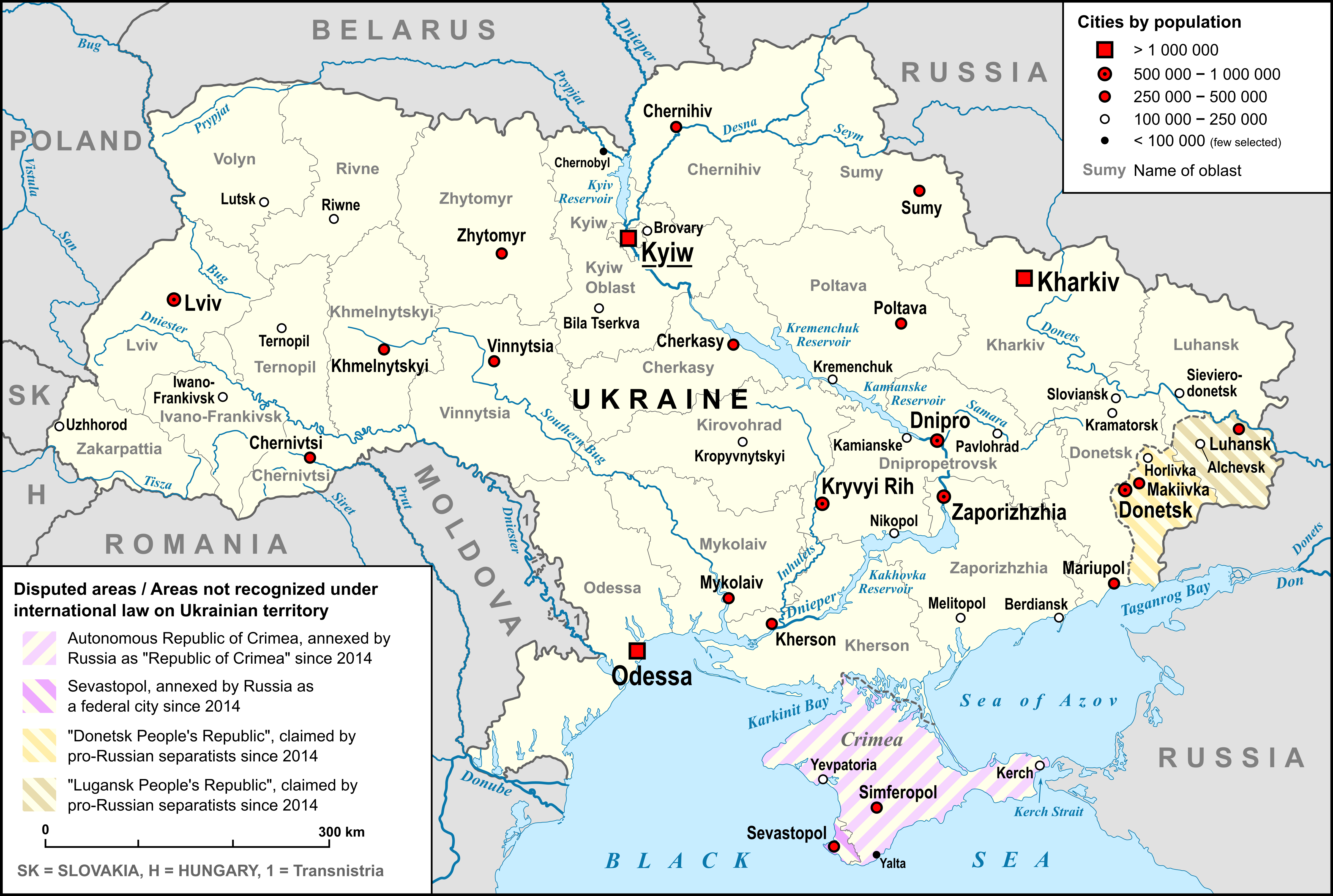
Radyvyliv (, ; ; ; ) is a small city in Rivne Oblast (region) of western Ukraine. It was the administrative center of the former Radyvyliv Raion (district) until its dissolution in 2020, and is located south-west of the oblast capital, Rivne, near European route E40. The nearest larger cities are Dubno and Brody; the latter being away. In Soviet times, from 1939 to 1992, the city was known as Chervonoarmiisk (, ). Population: History In the 14th century, together with whole Volhynia, Radyvyliv was annexed by the Grand Duchy of Lithuania. Following the 1569 Union of Lublin, the town was transferred to the Kingdom of Poland, where it remained for over 200 years. As a result of the Partitions of Poland, Radziwiłłow, as it was called, became a town of the Kremenetsky Uyezd in the Volhynian Governorate of the Russian Empire. In the late 1800s, the Jewish population reached 4,000. Between World War I and the civil war between Ukrainian nationalists and Bolsheviks, the Jewish pop ... [...More Info...] [...Related Items...] OR: [Wikipedia] [Google] [Baidu] |
Radyvyliv Raion
Radyvyliv Raion () was a raion in Rivne Oblast in western Ukraine. Its administrative center was the town of Radyvyliv. The raion was abolished and its territory was merged into Dubno Raion on 18 July 2020 as part of the administrative reform of Ukraine, which reduced the number of raions of Rivne Oblast to four. The last estimate of the raion population was See also * Subdivisions of Ukraine The administrative divisions of Ukraine ( ) are under the jurisdiction of the Constitution of Ukraine, Ukrainian Constitution. Ukraine is a unitary state with three levels of administrative divisions: 27 regions (24 Oblasts of Ukraine, oblasts ... References Former raions of Rivne Oblast 1939 establishments in Ukraine Ukrainian raions abolished during the 2020 administrative reform {{Rivne-geo-stub ... [...More Info...] [...Related Items...] OR: [Wikipedia] [Google] [Baidu] |
Rivne Oblast
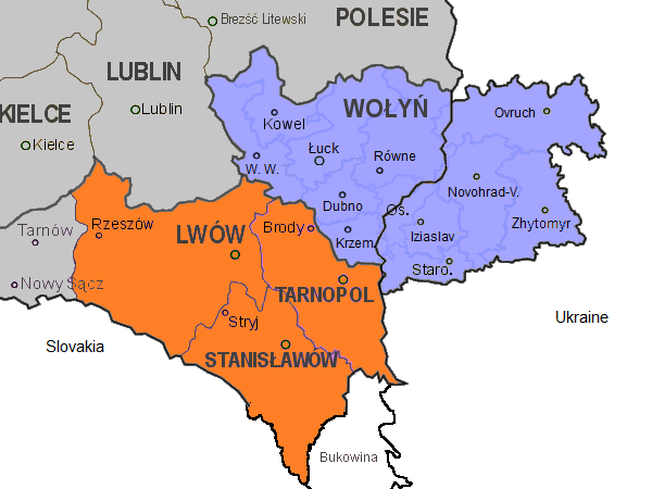
Rivne Oblast (), also referred to as Rivnenshchyna (), is an administrative divisions of Ukraine, oblast in western Ukraine. Its administrative center is Rivne. The surface area of the region is . Its population is: Before its annexation by the Soviet Union during World War II, the region was part of the Second Polish Republic's Wołyń Voivodeship (1921–1939), Wołyń Voivodeship following the Polish–Soviet War. Previously it was part of the Volhynian Governorate. The Rivne Nuclear Power Plant is located in the oblast, near the city of Varash. Geography The region is located almost in the middle of the historical region of Volhynia which is indicated on its coat of arms with a white cross on a red background. Volhynia was completely partitioned after the Soviet occupation of Poland in September 1939 and divided between three oblasts, Volyn Oblast, Volyn, Rivne, and Ternopil Oblast, Ternopil, with some additional eastern portions in Zhytomyr Oblast. The relief of the regio ... [...More Info...] [...Related Items...] OR: [Wikipedia] [Google] [Baidu] |
List Of Cities In Ukraine
There are 463 populated places in Ukraine, populated places in Ukraine that have been officially granted city status () by the Verkhovna Rada, the country's parliament, as of 23 April 2025. Settlements with more than 10,000 people are eligible for city status although the status is typically also granted to settlements of historical or regional importance. Smaller settlements are Populated places in Ukraine#Rural settlements, rural settlements () and villages (). Historically, there were systems of city rights, granted by the territorial lords, which defined the status of a place as a ''misto'' or ''selo''. In the past, cities were self-governing and had several privileges. The list of cities is roughly ordered by population and the 2022 estimates are compared to the 2001 Ukrainian census, except for Chernobyl for which the population is an unofficial estimate. The City with special status, cities with special status are shown in ''italic''. The average population size is 62,000. ... [...More Info...] [...Related Items...] OR: [Wikipedia] [Google] [Baidu] |
Second Polish Republic
The Second Polish Republic, at the time officially known as the Republic of Poland, was a country in Central and Eastern Europe that existed between 7 October 1918 and 6 October 1939. The state was established in the final stage of World War I. The Second Republic was taken over in 1939, after it was invaded by Nazi Germany, the Soviet Union, and the Slovak Republic, marking the beginning of the European theatre of the Second World War. The Polish government-in-exile was established in Paris and later London after the fall of France in 1940. When, after several regional conflicts, most importantly the victorious Polish-Soviet war, the borders of the state were finalized in 1922, Poland's neighbours were Czechoslovakia, Germany, the Free City of Danzig, Lithuania, Latvia, Romania, and the Soviet Union. It had access to the Baltic Sea via a short strip of coastline known as the Polish Corridor on either side of the city of Gdynia. Between March and August 1939, Poland a ... [...More Info...] [...Related Items...] OR: [Wikipedia] [Google] [Baidu] |
World War I
World War I or the First World War (28 July 1914 – 11 November 1918), also known as the Great War, was a World war, global conflict between two coalitions: the Allies of World War I, Allies (or Entente) and the Central Powers. Fighting took place mainly in European theatre of World War I, Europe and the Middle Eastern theatre of World War I, Middle East, as well as in parts of African theatre of World War I, Africa and the Asian and Pacific theatre of World War I, Asia-Pacific, and in Europe was characterised by trench warfare; the widespread use of Artillery of World War I, artillery, machine guns, and Chemical weapons in World War I, chemical weapons (gas); and the introductions of Tanks in World War I, tanks and Aviation in World War I, aircraft. World War I was one of the List of wars by death toll, deadliest conflicts in history, resulting in an estimated World War I casualties, 10 million military dead and more than 20 million wounded, plus some 10 million civilian de ... [...More Info...] [...Related Items...] OR: [Wikipedia] [Google] [Baidu] |
January Uprising
The January Uprising was an insurrection principally in Russia's Kingdom of Poland that was aimed at putting an end to Russian occupation of part of Poland and regaining independence. It began on 22 January 1863 and continued until the last insurgents were captured by the Russian forces in 1864. It was the longest-lasting insurgency in partitioned Poland. The conflict engaged all levels of society and arguably had profound repercussions on contemporary international relations and ultimately transformed Polish society. A confluence of factors rendered the uprising inevitable in early 1863. The Polish nobility and urban bourgeois circles longed for the semi-autonomous status they had enjoyed in Congress Poland before the previous insurgency, a generation earlier in 1830, and youth encouraged by the success of the Italian independence movement urgently desired the same outcome. Russia had been weakened by its Crimean adventure and had introduced a more liberal attitude in its ... [...More Info...] [...Related Items...] OR: [Wikipedia] [Google] [Baidu] |
Volhynia
Volhynia or Volynia ( ; see #Names and etymology, below) is a historic region in Central and Eastern Europe, between southeastern Poland, southwestern Belarus, and northwestern Ukraine. The borders of the region are not clearly defined, but in Ukraine it is roughly equivalent to Volyn Oblast, Volyn and Rivne Oblasts; the territory that still carries the name is Volyn Oblast. Volhynia has changed hands numerous times throughout history and been divided among competing powers. For centuries it was part of the Polish-Lithuanian Commonwealth. After the Russian annexation during the Partitions of Poland, all of Volhynia was made part of the Pale of Settlement on the southwestern border of the Russian Empire. Important cities include Rivne, Lutsk, Zviahel, and Volodymyr (city), Volodymyr. Names and etymology *, ; * ; *, ; * or ; *; * ; *; *; * or (both ); Volhynian German: , , or (all ); *, or . The alternative name for the region is Lodomeria after the city of Volodymyr (city ... [...More Info...] [...Related Items...] OR: [Wikipedia] [Google] [Baidu] |
Russian Empire
The Russian Empire was an empire that spanned most of northern Eurasia from its establishment in November 1721 until the proclamation of the Russian Republic in September 1917. At its height in the late 19th century, it covered about , roughly one-sixth of the world's landmass, making it the list of largest empires, third-largest empire in history, behind only the British Empire, British and Mongol Empire, Mongol empires. It also Russian colonization of North America, colonized Alaska between 1799 and 1867. The empire's 1897 census, the only one it conducted, found a population of 125.6 million with considerable ethnic, linguistic, religious, and socioeconomic diversity. From the 10th to 17th centuries, the Russians had been ruled by a noble class known as the boyars, above whom was the tsar, an absolute monarch. The groundwork of the Russian Empire was laid by Ivan III (), who greatly expanded his domain, established a centralized Russian national state, and secured inde ... [...More Info...] [...Related Items...] OR: [Wikipedia] [Google] [Baidu] |
Volhynian Governorate
Volhynia Governorate, also known as Volyn Governorate, was an administrative-territorial unit (''guberniya'') of the Southwestern Krai of the Russian Empire. It consisted of an area of and a population of 2,989,482 inhabitants. The governorate bordered Grodno Governorate, Grodno and Minsk Governorate, Minsk Governorates to the north, Kiev Governorate to the east, Podolia Governorate to the south, Lublin Governorate, Lublin and Siedlce Governorate, Siedlce Governorates, and after 1912, Kholm Governorate (Russian Empire), Kholm Governorate and Austria-Hungary, Austria to the west. Its capital was in Novograd-Volynsky until 1804, and then Zhitomir. It corresponded to most of modern-day Volyn Oblast, Volyn, Rivne Oblast, Rivne and Zhytomyr Oblast, Zhytomyr Oblasts of Ukraine and some parts of Brest Region, Brest and Gomel Region, Gomel Regions of Belarus. It was created at the end of 1796 after the Third Partition of Poland from the territory of the short-lived Volhynian Vice-royalt ... [...More Info...] [...Related Items...] OR: [Wikipedia] [Google] [Baidu] |
Kremenetsky Uyezd
Kremenetsky Uyezd (''Кременецкий уезд''; ''Кременецький повіт'') was one of the subdivisions of the Volhynian Governorate of the Russian Empire. It was situated in the southern part of the governorate. Its administrative centre was Kremenets. Demographics At the time of the Russian Empire Census of 1897, Kremenetsky Uyezd had a population of 219,934. Of these, 80.7% spoke Ukrainian, 12.2% Yiddish, 3.4% Russian, 3.0% Polish, 0.3% Tatar, 0.1% Czech and 0.1% German German(s) may refer to: * Germany, the country of the Germans and German things **Germania (Roman era) * Germans, citizens of Germany, people of German ancestry, or native speakers of the German language ** For citizenship in Germany, see also Ge ... as their native language. Демоскоп Weekly - Приложение. Справочник статист ... [...More Info...] [...Related Items...] OR: [Wikipedia] [Google] [Baidu] |


