|
R600 (South Africa)
The R600 is a Regional Route in South Africa. Route Its north-eastern terminus is the N11 south-west of Ladysmith, just east of the N11's divergence from the N3. It heads southwest, crossing the N3 to reach Winterton, where it intersects the R74 at a staggered junction. From Winterton, it continues south-west, ending at the Champagne Castle Champagne Castle is a mountain in the central Drakensberg range, and is the second highest peak in South Africa. It contains a series of subsidiary peaks, amongst them, Cathkin Peak (3149 m), Sterkhorn (previously called Mount Memory), Monk's ... hotel at an entrance to uKhahlamba / Drakensberg Park. References Regional routes in KwaZulu-Natal {{SouthAfrica-road-stub ... [...More Info...] [...Related Items...] OR: [Wikipedia] [Google] [Baidu] |
Regional Route (South Africa)
__NOTOC__Regional routes (also sometimes known as minor regional routes) are the third category of road in the South African route numbering scheme. They are designated with the letter "R" followed by a three-digit number. They serve as feeders connecting smaller towns to the national and provincial routes. Designation as a regional road does not necessarily imply any particular size of road; they range from gravel roads (like the R340 between Plettenberg Bay and Uniondale) to multi-lane freeways (like the R300 near Cape Town). Although most regional roads are maintained by provincial road authorities, this is not universally the case; in provinces which lack capacity, some may be under the control of the National Roads Agency (SANRAL), and in urban areas they may be ordinary streets under the control of the municipal roads department. Similarly, some national (N) roads and freeways are under the control of provincial or municipal authorities rather than SANRAL. List of ro ... [...More Info...] [...Related Items...] OR: [Wikipedia] [Google] [Baidu] |
South Africa
South Africa, officially the Republic of South Africa (RSA), is the Southern Africa, southernmost country in Africa. Its Provinces of South Africa, nine provinces are bounded to the south by of coastline that stretches along the Atlantic Ocean, South Atlantic and Indian Ocean; to the north by the neighbouring countries of Namibia, Botswana, and Zimbabwe; to the east and northeast by Mozambique and Eswatini; and it encloses Lesotho. Covering an area of , the country has Demographics of South Africa, a population of over 64 million people. Pretoria is the administrative capital, while Cape Town, as the seat of Parliament of South Africa, Parliament, is the legislative capital, and Bloemfontein is regarded as the judicial capital. The largest, most populous city is Johannesburg, followed by Cape Town and Durban. Cradle of Humankind, Archaeological findings suggest that various hominid species existed in South Africa about 2.5 million years ago, and modern humans inhabited the ... [...More Info...] [...Related Items...] OR: [Wikipedia] [Google] [Baidu] |
Ladysmith, KwaZulu-Natal
uMnambithi (formerly Ladysmith until 2024) is a town in the Uthukela District of KwaZulu-Natal, South Africa. It lies north-west of Durban and south-east of Johannesburg. Important industries in the area include food processing, textiles, and tyre production. uMnambithi is the seat for both the Alfred Duma Local Municipality and Uthukela District Municipality. The town was named after Juana María de los Dolores de León Smith, also known as "Lady Smith," the Spanish wife of Sir Harry Smith, the Governor of the Cape Colony from 1847–1852. It held strategic importance during the Second Boer War when, after numerous small skirmishes, it was besieged by Boer forces on 2 November 1899. After three British attempts to relieve the defenders and one Boer attempt to take the town all failed, the siege was eventually broken on 28 February 1900. Both Winston Churchill and Mahatma Gandhi were present at the siege, the former as a war correspondent and the latter as a ... [...More Info...] [...Related Items...] OR: [Wikipedia] [Google] [Baidu] |
Winterton, KwaZulu-Natal
Winterton is a small town on the banks of the Tugela River in the foothills of the Drakensberg mountains, KwaZulu-Natal, South Africa. It was founded in 1905 as Springfield when the Colony of Natal, Natal Government built a weir across the Little Tugela River. The town later changed its name to Winterton in honour the secretary for agriculture, HD Winter. Winterton is a small town with only a primary school. It is close to the Second Boer War battle sites of Battle of Vaal Krantz and Battle of Spion Kop, Spioenkop. The town is situated on the R74 (South Africa), R74 between Bergville and the N3 (South Africa), N3, as well as the R600 (South Africa), R600 between Ladysmith, KwaZulu-Natal, Ladysmith and the Central Drakensberg. Winterton also serves as an entry point to the Champagne Valley as well as the Cathedral area of the central Drakensberg, boasting well known mountain peaks such as Champagne Castle and Cathedral Peak (South Africa), Cathedral Peak respectively - these mounta ... [...More Info...] [...Related Items...] OR: [Wikipedia] [Google] [Baidu] |
Champagne Castle
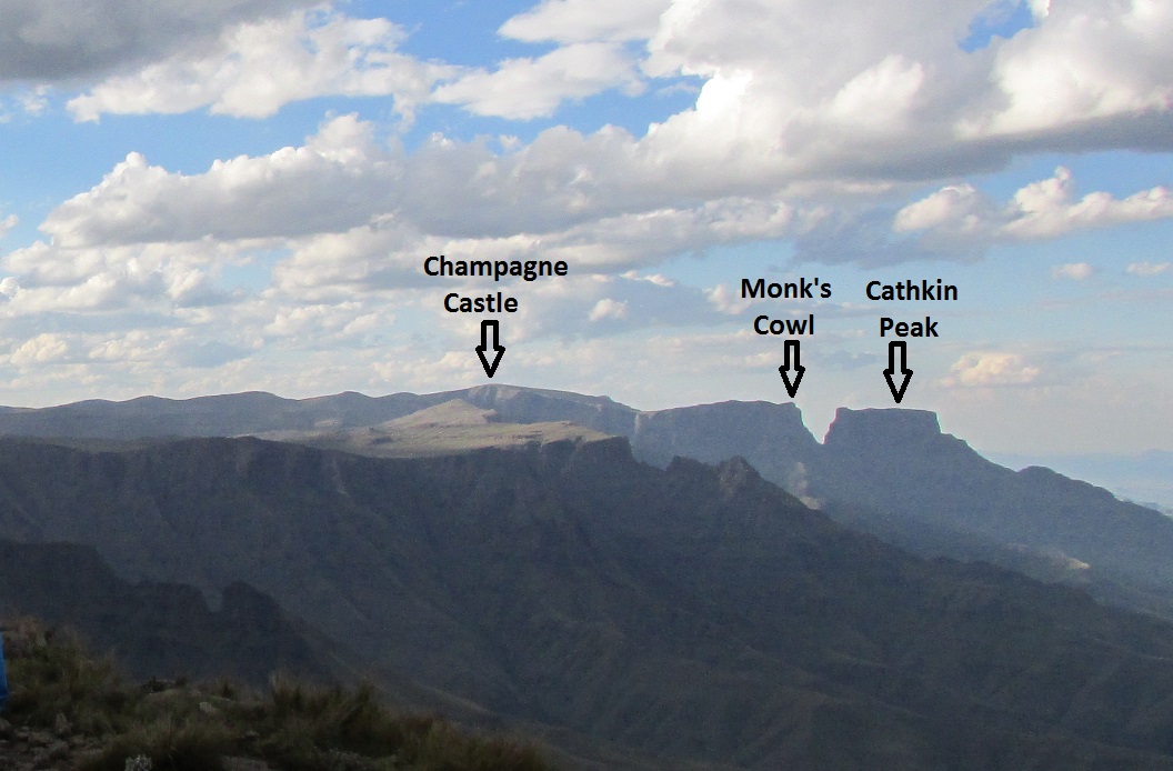
Champagne Castle is a mountain in the central Drakensberg range, and is the second highest peak in South Africa. It contains a series of subsidiary peaks, amongst them, Cathkin Peak (3149 m), Sterkhorn (previously called Mount Memory), Monk's Cowl and Dragon's Back. It is said that when two intrepid mountaineers, David Gray and Major Grantham, climbed the peaks directly in front of Cathkin, they were about to celebrate their long haul by popping a bottle of champagne. But as fate would have it, the guide dropped the bottle on a rock – and in that moment Champagne Castle in the heart of the Drakensberg was christened. Cathkin Peak was named after the residence of a Lanarkshire Lanarkshire, also called the County of Lanark (; ), is a Counties of Scotland, historic county, Lieutenancy areas of Scotland, lieutenancy area and registration county in the Central Lowlands and Southern Uplands of Scotland. The county is no l ... immigrant, Stephan Snyman, who named his home afte ... [...More Info...] [...Related Items...] OR: [Wikipedia] [Google] [Baidu] |
N11 Road (South Africa)
The N11 is a national route in South Africa which runs from the Botswana border at Groblersbrug, through Mokopane, Middelburg, Ermelo and Newcastle to end at the N3 just after Ladysmith. Route Limpopo The N11 begins at the Grobler's Bridge Border with Botswana on the Limpopo River. On the Botswana side of the Limpopo River, the border post is known as Martin's Drift. It begins by running south-east through Limpopo province for 190 kilometres to Mokopane. Upon entering Mokopane (at Masehlaneng), the N11 is joined by the R518 and they form one road into Mokopane Central. At the junction with the R101 road (Thabo Mbeki Drive) in the town centre, the N11 and the R518 join the R101 southwards. At the second junction afterwards (by Mokopane Mall), the R518 becomes its own road eastwards towards Zebediela, leaving the R101 and the N11 as the road southwards (Thabo Mbeki Drive). After 11 kilometres, the N11 becomes its own road towards the south-south-east and meets the N1 hi ... [...More Info...] [...Related Items...] OR: [Wikipedia] [Google] [Baidu] |
N3 Road (South Africa)
The N3 is a national route in South Africa that connects Johannesburg and Durban, respectively South Africa's largest and third-largest cities. Johannesburg is the financial and commercial heartland of South Africa, while Durban is South Africa's key port and one of the busiest ports in the Southern Hemisphere and is also a holiday destination. Durban is the port through which Johannesburg imports and exports most of its goods. As a result, the N3 is a very busy highway and has a high volume of traffic. Route The N3 is divided into 12 sections, starting with section 1 in Durban and ending with section 12 in Johannesburg. Between the two cities, the route passes the following towns and cities: Pinetown, Cato Ridge, Pietermaritzburg, Howick, Mooi River, Estcourt, Ladysmith, Van Reenen, Harrismith, Warden, Villiers, Heidelberg and Germiston. It no longer passes through most of these towns, as bypasses have been built around all of them (the N3 does not pass through any ci ... [...More Info...] [...Related Items...] OR: [Wikipedia] [Google] [Baidu] |
Winterton, KwaZulu–Natal
Winterton is a small town on the banks of the Tugela River in the foothills of the Drakensberg mountains, KwaZulu-Natal, South Africa. It was founded in 1905 as Springfield when the Natal Government built a weir across the Little Tugela River. The town later changed its name to Winterton in honour the secretary for agriculture, HD Winter. Winterton is a small town with only a primary school. It is close to the Second Boer War battle sites of Battle of Vaal Krantz and Spioenkop. The town is situated on the R74 between Bergville and the N3, as well as the R600 between Ladysmith and the Central Drakensberg. Winterton also serves as an entry point to the Champagne Valley as well as the Cathedral area of the central Drakensberg, boasting well known mountain peaks such as Champagne Castle and Cathedral Peak respectively - these mountains are considered to be among the most spectacular sights in Southern Africa. The world-famous Drakensberg Boys' Choir School Drakensberg B ... [...More Info...] [...Related Items...] OR: [Wikipedia] [Google] [Baidu] |
R74 Road (South Africa)
The R74 is a provincial route in South Africa that connects Harrismith with KwaDukuza (previously Stanger) on the coast, via Oliviershoek Pass, Bergville, Winterton, Colenso, Weenen and Greytown. Route Free State The R74 begins in Harrismith, Free State, at a t-junction with the N5 national route south of the town centre. It begins by going southwards for eight kilometres to meet the eastern terminus of the R712 road, which connects to Phuthaditjhaba. KwaZulu-Natal The R74 continues south-south-east for sixty-four kilometres, crossing into the KwaZulu-Natal Province, bypassing the Woodstock Dam, to enter the town of Bergville, where it meets the western terminus of the R616 road. Just after the Bergville town centre, the R74 crosses the Tugela River. From Bergville, the R74 continues south-east for 20 kilometres to meet the R600 road and enter the town of Winterton, where it crosses the Little Tugela River in the town centre. It continues south-east for twenty-tw ... [...More Info...] [...Related Items...] OR: [Wikipedia] [Google] [Baidu] |
UKhahlamba / Drakensberg Park
The uKhahlamba-Drakensberg Park is a protected area in the KwaZulu-Natal province of South Africa, covering , and is part of the Maloti-Drakensberg Park, a UNESCO World Heritage Site. The park includes Royal Natal National Park, a Provincial park, and covers part of the Drakensberg, an escarpment formation with the highest elevations in southern Africa. The park and the adjoining Sehlabathebe National Park in the Kingdom of Lesotho are part of the Maloti-Drakensberg Park, which was first declared a World Heritage Site on 30 November 2000. It is described by UNESCO as having "exceptional natural beauty in its soaring basaltic buttresses, incisive dramatic cutbacks, and golden sandstone ramparts... the site’s diversity of habitats protects a high level of endemic and globally threatened species, especially birds and plants... nd italso contains many caves and rock-shelters with the largest and most concentrated group of paintings in Africa south of the Sahara". The paintings men ... [...More Info...] [...Related Items...] OR: [Wikipedia] [Google] [Baidu] |


