|
Quapaw
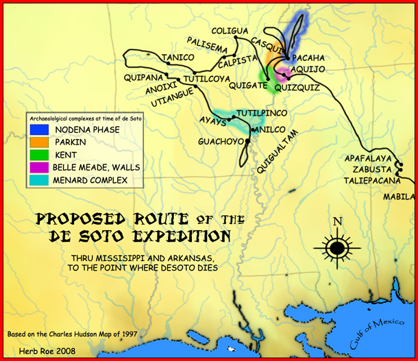
The Quapaw ( , Quapaw language, Quapaw: ) or Arkansas, officially the Quapaw Nation, is a List of federally recognized tribes in the United States, U.S. federally recognized tribe comprising about 6,000 citizens. Also known as the Ogáxpa or “Downstream” people, their ancestral homelands are traced from what is now the Ohio River, west to the Mississippi River to present-day St. Louis, south across present-day Arkansas and eastern and southern Oklahoma. The government Trail of Tears, forcibly removed them from Arkansas Territory in 1834. The Oklahoma Tribal Statistical Area, tribal Capital city, capital is Quapaw, Oklahoma, Quapaw, Oklahoma. Etymology The Quapaw broke from the other Dhegiha tribes and migrated down the Mississippi River into present-day Arkansas many generations before European contact. After that, the tribe began to refer to themselves Ogáxpa, which means the “Downstream” people." This was the name of their primary village or tribal band. Historicall ... [...More Info...] [...Related Items...] OR: [Wikipedia] [Google] [Baidu] |
Quapaw Language
Quapaw, or Arkansas, is a Siouan language of the Quapaw people, originally from a region in present-day Arkansas. It is now spoken in Oklahoma. It is similar to the other Dhegihan languages: Kansa, Omaha, Osage and Ponca. Written documentation The Quapaw language is well-documented in field notes and publications from many individuals including by George Izard in 1827, by Lewis F. Hadly in 1882, from 19th-century linguist James Owen Dorsey, in 1940 by Frank Thomas Siebert, and, in the 1970s by linguist Robert Rankin. The Quapaw language does not conform well to English language phonetics, and a writing system for the language has not been formally adopted. All of the existing source material on the language utilizes different writing systems, making reading and understanding the language difficult for the novice learner. To address this issue, an online dictionary of the Quapaw language is being compiled which incorporates all of the existing source material known to exi ... [...More Info...] [...Related Items...] OR: [Wikipedia] [Google] [Baidu] |
Quapaw, Oklahoma
Quapaw, officially the Town of Quapaw, is a town in Ottawa County, Oklahoma, United States, which serves as the capital of the Quapaw Nation. Located about northeast of Miami, it is part of the Joplin, Missouri metropolitan area. Incorporated in 1917,Mickey Johnson, ''Quapaw,'' Encyclopedia of Oklahoma History and Culture. Accessed March 15, 2015 Quapaw's population was 811 in 2020. History In 1891, Kansas farmer Isaac Bingham moved his family south into Ottawa County, then part of land assigned to the Quapaw Nation. It became part of the state of Oklahoma in 1907 after admission. The family founded a community and opened several businesses. Q ...[...More Info...] [...Related Items...] OR: [Wikipedia] [Google] [Baidu] |
Arkansas Post
The Arkansas Post (; ), officially the Arkansas Post National Memorial, was the first European colonization of the Americas, European settlement located along the Mississippi River, in the Mississippi Alluvial Plain, and in the present-day U.S. state of Arkansas. In 1686, Henri de Tonti established it on behalf of Louis XIV, Louis XIV of France for the purpose of trading with the Quapaw, Quapaw Nation. The Kingdom of France, French, Spanish Empire, Spanish, and Americans, who acquired the territory in 1803 with the Louisiana Purchase, considered the site of strategic value. It was the capital of Arkansas Territory, Arkansas from 1819 until 1821 when the territorial government relocated to Little Rock, Arkansas, Little Rock. During the fur trade years, Arkansas Post was protected by a series of fortifications. The forts and associated settlements were located at three known sites and possibly a fourth. Some of the historic structures have been lost as the waterfront has been ... [...More Info...] [...Related Items...] OR: [Wikipedia] [Google] [Baidu] |
Dhegihan History And Separation
The Dhegihan migration and separation was the long journey on foot by the North American Indians in the ancient Hą́ke tribe. During the migration from present-day Illinois/Kentucky and as far as Nebraska, they gradually split up into five groups. Each became an independent and historic tribe. They are the Omaha, Ponca, Kaw or Kansa, Osage and Quapaw. The term "Dhegiha" refers to all five Indian tribes since they each speak a Dhegiha Siouan language. Besides having related languages, they share an oral tradition about a common origin from an ancestral tribe. The timing of the separation for these tribes and history prior to their existence as separate groups is the subject of some debate. Pre-separation The Quapaw, the Ponca, the Omaha, the Osage and the Kaw share a tradition, that back in time they were one people. The claim is supported by similar tribal organization with kinship groups (clans) and closely related languages, although some of the tribes were widely scatter ... [...More Info...] [...Related Items...] OR: [Wikipedia] [Google] [Baidu] |
Ponca
The Ponca people are a nation primarily located in the Great Plains of North America that share a common Ponca culture, history, and language, identified with two Indigenous nations: the Ponca Tribe of Indians of Oklahoma or the Ponca Tribe of Nebraska. This nation comprised the modern-day Ponca, Omaha people, Omaha, Kaw people, Kaw, Osage people, Osage, and Quapaw people, Quapaw peoples until the mid-17th century when the people sought to establish their nation west of the Mississippi River as a result of the Beaver Wars. By the end of the 18th century, the Ponca people had established themselves at the mouth of the Niobrara River near its confluence with the Missouri River, remaining there until 1877 when the United States Indian removal, forcibly removed the Ponca people from the Ponca Reservation in the Dakota Territory to the Indian Territory. This event, known as the Ponca Trail of Tears, resulted in the deaths of hundreds of Ponca civilians and the splintering of the nati ... [...More Info...] [...Related Items...] OR: [Wikipedia] [Google] [Baidu] |
Arkansas
Arkansas ( ) is a landlocked state in the West South Central region of the Southern United States. It borders Missouri to the north, Tennessee and Mississippi to the east, Louisiana to the south, Texas to the southwest, and Oklahoma to the west. Its name derives from the Osage language, and refers to their relatives, the Quapaw people. The state's diverse geography ranges from the mountainous regions of the Ozark and Ouachita Mountains, which make up the U.S. Interior Highlands, to the densely forested land in the south known as the Arkansas Timberlands, to the eastern lowlands along the Mississippi River and the Arkansas Delta. Previously part of French Louisiana and the Louisiana Purchase, the Territory of Arkansas was admitted to the Union as the 25th state on June 15, 1836. Much of the Delta had been developed for cotton plantations, and landowners there largely depended on enslaved African Americans' labor. In 1861, Arkansas seceded from the United St ... [...More Info...] [...Related Items...] OR: [Wikipedia] [Google] [Baidu] |
Dhegiha
The Dhegihan languages are a group of Siouan languages that include Kansa– Osage, Omaha–Ponca, and Quapaw. Their historical region included parts of the Ohio and Mississippi River Valleys, the Great Plains, and southeastern North America. The shared Dhegihan migration story places them as a united group in the late 1600s near the confluence of the Ohio and Tennessee rivers (southern Illinois and western Kentucky) which then moved westward towards the Missouri River, and separated into different bands. However, some oral traditions and archeological evidence indicate that Dhegihan speaking peoples may have migrated west out of the Ohio River Valley much earlier. The Dhegihan languages were first described and classified as Siouan languages by James Dorsey in 1885. According to Dorsey, "Degiha" translates to "Belonging to the people of this land" or "Those who dwell here" in Omaha-Ponca. Other dialectical variants recorded by Dorsey with the same translation include "Ye-ga-ha ... [...More Info...] [...Related Items...] OR: [Wikipedia] [Google] [Baidu] |
Dhegihan Languages
The Dhegihan languages are a group of Siouan languages that include Kansa– Osage, Omaha–Ponca, and Quapaw. Their historical region included parts of the Ohio and Mississippi River Valleys, the Great Plains, and southeastern North America. The shared Dhegihan migration story places them as a united group in the late 1600s near the confluence of the Ohio and Tennessee rivers (southern Illinois and western Kentucky) which then moved westward towards the Missouri River The Missouri River is a river in the Central United States, Central and Mountain states, Mountain West regions of the United States. The nation's longest, it rises in the eastern Centennial Mountains of the Bitterroot Range of the Rocky Moun ..., and separated into different bands. However, some oral traditions and archeological evidence indicate that Dhegihan speaking peoples may have migrated west out of the Ohio River Valley much earlier. The Dhegihan languages were first described and classified as S ... [...More Info...] [...Related Items...] OR: [Wikipedia] [Google] [Baidu] |
Omaha People
The Omaha are a federally recognized Midwestern Native American tribe who reside on the Omaha Reservation in northeastern Nebraska and western Iowa, United States. The Omaha Indian Reservation lies primarily in the southern part of Thurston County and northeastern Cuming County, Nebraska, but small parts extend into the northeast corner of Burt County and across the Missouri River into Monona County, Iowa. Its total land area is and a population of 5,194 was recorded in the 2000 census. Its largest community is Macy. The Omaha people migrated to the upper Missouri area and the Plains by the late 17th century from earlier locations in the Ohio River Valley. The Omaha speak a Siouan language of the Dhegihan branch, which is very similar to that spoken by the Ponca. The latter were part of the Omaha before splitting off into a separate tribe in the mid-18th century. They are also related to the Osage, Quapaw, and Kansa peoples, who also migrated from the Ohio Valley. A ... [...More Info...] [...Related Items...] OR: [Wikipedia] [Google] [Baidu] |
Osage Nation
The Osage Nation ( ) () is a Midwestern Native American nation of the Great Plains. The tribe began in the Ohio and Mississippi river valleys around 1620 A.D along with other groups of its language family, then migrated west in the 17th century due to Iroquois incursions. The term "Osage" is a French version of the tribe's name, which can be roughly translated as "calm water". The Osage people refer to themselves in their Dhegihan Siouan language as (). By the early 19th century, the Osage had become the dominant power in the region, feared by neighboring tribes. The tribe controlled the area between the Missouri and Red rivers, the Ozarks to the east and the foothills of the Wichita Mountains to the south. They depended on nomadic buffalo hunting and agriculture. The 19th-century painter George Catlin described the Osage as "the tallest race of men in North America, either red or white skins; there being ... many of them six and a half, and others taller than seven f ... [...More Info...] [...Related Items...] OR: [Wikipedia] [Google] [Baidu] |
Oklahoma
Oklahoma ( ; Choctaw language, Choctaw: , ) is a landlocked U.S. state, state in the South Central United States, South Central region of the United States. It borders Texas to the south and west, Kansas to the north, Missouri to the northeast, Arkansas to the east, New Mexico to the west, and Colorado to the northwest. Partially in the western extreme of the Upland South, it is the List of U.S. states and territories by area, 20th-most extensive and the List of U.S. states and territories by population, 28th-most populous of the 50 United States. Its residents are known as Oklahomans and its capital and largest city is Oklahoma City. The state's name is derived from the Choctaw language, Choctaw words , 'people' and , which translates as 'red'. Oklahoma is also known informally by its List of U.S. state and territory nicknames, nickname, "The Sooner State", in reference to the Sooners, American pioneer, American settlers who staked their claims in formerly American Indian-o ... [...More Info...] [...Related Items...] OR: [Wikipedia] [Google] [Baidu] |


