|
Qiangtang Terrane
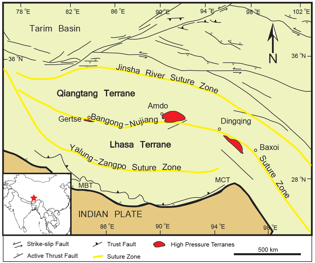
The Qiantang terrane is one of three main west-east-trending terranes of the Tibetan Plateau. During the Triassic, a southward-directed subduction along its northern margin resulted in the Jin-Shajing suture, the limit between it and the Songpan-Ganzi terrane. During the Late Jurassic and Early Cretaceous, the Lhasa terrane merged with its southern margin along the Bangong suture. This suture, the closure of part of the Tethys Ocean, transformed the Qiantang terrane into a large-scale anticline. The merging of the Lhasa and Qiangtang terranes resulted in the uplift of a palaeoplateau known as the Qiangtang Plateau, which rapidly thinned later in the Cretaceous. The Qiantang terrane is now located at above sea level, but the timing of this Orogeny, uplift remains debated, with estimates ranging from the Pliocene-Pleistocene (3–5 ) to the Eocene (35 Mya) when the plateau was first Denudation, denudated. See also Qiangtang terrane related (from south to north) * Ge ... [...More Info...] [...Related Items...] OR: [Wikipedia] [Google] [Baidu] |
Lithos (journal)
''Lithos'' is a peer review, peer-reviewed academic journal, publishing original research papers on the petrology, geochemistry and petrogenesis of Igneous rock, igneous and Metamorphic rock, metamorphic rocks. Lithos is a hybrid open-access journal and publishes both subscription and open access articles. References English-language journals Geology journals Elsevier academic journals {{geology-journal-stub ... [...More Info...] [...Related Items...] OR: [Wikipedia] [Google] [Baidu] |
Geology Of Tibet
Geology (). is a branch of natural science concerned with the Earth and other astronomical objects, the rocks of which they are composed, and the processes by which they change over time. Modern geology significantly overlaps all other Earth sciences, including hydrology. It is integrated with Earth system science and planetary science. Geology describes the structure of the Earth on and beneath its surface and the processes that have shaped that structure. Geologists study the mineralogical composition of rocks in order to get insight into their history of formation. Geology determines the relative ages of rocks found at a given location; geochemistry (a branch of geology) determines their absolute ages. By combining various petrological, crystallographic, and paleontological tools, geologists are able to chronicle the geological history of the Earth as a whole. One aspect is to demonstrate the age of the Earth. Geology provides evidence for plate tectonics, the evolutionary ... [...More Info...] [...Related Items...] OR: [Wikipedia] [Google] [Baidu] |
Earth And Planetary Science Letters
''Earth and Planetary Science Letters'' (EPSL) is a bimonthly peer-reviewed scientific journal covering research on physical, chemical and mechanical processes of the Earth and other planets, including extrasolar ones. Topics covered range from deep planetary interiors to atmospheres. The journal was established in 1966 and is published by Elsevier. The co-editors-in-chief are Tristan Horner, Yemane Asmerom, Jean-Philippe Avouac, James Badro, Huiming Bao, Rosemary Hickey-Vargas, Andrew Jacobson, Carolina Lithgow-Bertelloni, Olivier Mousis, Chiara Maria Petrone, Fang-Zhen Teng, Hans Thybo, Alexander Webb. Abstracting and indexing The journal is abstracted and indexed in: According to the ''Journal Citation Reports'', the journal has a 2023 impact factor The impact factor (IF) or journal impact factor (JIF) of an academic journal is a type of journal ranking. Journals with higher impact factor values are considered more prestigious or important within their field. The Impac ... [...More Info...] [...Related Items...] OR: [Wikipedia] [Google] [Baidu] |
Contributions To Mineralogy And Petrology
''Contributions to Mineralogy and Petrology'' is a peer-reviewed scientific journal published by Springer Science+Business Media since 1947. The journal is a hybrid open-access journal. The journal covers the fields of igneous and metamorphic petrology, geochemistry, and mineralogy. Abstracting and indexing This journal is indexed in the following databases: *Science Citation Index Expanded *Current Contents - Physical, Chemical & Earth Sciences * Chemical Abstracts *VINITI In 2018, the journal had an impact factor The impact factor (IF) or journal impact factor (JIF) of an academic journal is a type of journal ranking. Journals with higher impact factor values are considered more prestigious or important within their field. The Impact Factor of a journa ... of 3.23. References English-language journals Academic journals established in 1947 Springer Science+Business Media academic journals Geology journals 1947 establishments in the United States Mineralogy journa ... [...More Info...] [...Related Items...] OR: [Wikipedia] [Google] [Baidu] |
High Pressure Metamorphic Terranes Along The Bangong-Nujiang Suture Zone
High pressure terranes along the ~1200 km long east-west trending Bangong-Nujiang suture zone (BNS) on the Tibetan Plateau have been extensively mapped and studied. Understanding the geodynamic processes in which these terranes are created is key to understanding the development and subsequent deformation of the BNS and Eurasian deformation as a whole. Introduction With an average elevation of just above 5,000 m, the Tibetan Plateau is the largest elevated region on Earth. Explaining how such a large area (2.5 million km2) can have such high elevations has perplexed geologists for some time. It is known that significant tectonic activity took place before the Indo-Asian collision as terranes were being accreted onto the Eurasian plate during the Late Jurassic-Early Cretaceous, but the extent of deformation and the influence these earlier tectonic events had on the subsequent evolution of the Tibetan Plateau is poorly understood. In search of clues, geologists have looked to ... [...More Info...] [...Related Items...] OR: [Wikipedia] [Google] [Baidu] |
Karakoram Fault System
The Karakoram fault is an oblique-slip fault system in the Himalayan region across India and Asia. The slip along the fault accommodates radial expansion of the Himalayan arc, northward indentation of the Pamir Mountains, and eastward lateral extrusion of the Tibetan plateau. Current Tectonic plate, plate motions suggest that the convergence between the Indian plate and the Eurasian plate is around 44±5 mm per year in the western Himalaya-Pamir region and approximately 50±2 mm per year in the eastern Himalayan region. Origin The creation of the Karakoram fault started with the closing of the ancient Tethys Ocean seaway which once separated the two modern continents of Asia and India. The Karakoram fault itself does not trace a plate boundary, except for where it possibly ends in the Indus-Yarlung suture zone, Indus-Yarlung Suture Zone. The original thrusting occurred by linking existing thrust faults in what is now the Pamir Mountains starting between 17 and 20 million ... [...More Info...] [...Related Items...] OR: [Wikipedia] [Google] [Baidu] |
Transhimalaya
The Trans himalaya (also spelled Trans-Himalaya), or "Gangdise – Nyenchen Tanglha range" ( zh, s=冈底斯-念青唐古拉山脉, p=Gāngdǐsī-Niànqīngtánggǔlā Shānmài), is a mountain range in China, India and Nepal, extending in a west–east direction parallel to the main Himalayan range. Located north of Yarlung Tsangpo river on the southern edge of the Tibetan Plateau, the Transhimalaya is composed of the Gangdise range to the west and the Nyenchen Tanglha range to the east. The name ''Transhimalaya'' was introduced by the Swedish geographer Sven Hedin in early 20th century. The Transhimalaya was described by the ''Columbia Lippincott Gazetteer'' in 1952 as an "ill-defined mountain area" with "no marked crest line or central alignment and no division by rivers." On more-modern maps the Kailas Range (Gangdise or Kang-to-sé Shan) in the west is shown as distinct from the Nyenchen Tanglha range in the east. Geology The Transhimalayas are geologically distinct f ... [...More Info...] [...Related Items...] OR: [Wikipedia] [Google] [Baidu] |
Indus-Yarlung Suture Zone
The Indus-Yarlung suture zone or the Indus-Yarlung Tsangpo suture is a tectonic suture in southern Tibet and across the north margin of the Himalayas which resulted from the collision between the Indian Plate and the Eurasian Plate starting about 52 Ma. The north side of the suture zone is the Ladakh Batholith of the Karakoram-Lhasa Block. The rocks of the suture zone consist of an ophiolite mélanges composed of Neotethys oceanic crustal flyschs and ophiolites; the Dras Volcanics: which are basalts, dacites and minor radiolarian cherts – the remains of a mid- to late Mesozoic volcanic island arc; and the Indus Molasse which are an Eocene or later continental clastic sediments. The ophiolites within the Indus-Yarlung suture zone occur in two discontinuous belts. During the trench-continent collision, segments of the crust and upper mantle were emplaced onto the Indian Plate. However, following the collision of the Indian and Eurasian plates, the northern segment of ophio ... [...More Info...] [...Related Items...] OR: [Wikipedia] [Google] [Baidu] |
Geology Of The Himalaya
The geology of the Himalayas is a record of the most dramatic and visible creations of the immense mountain range formed by plate tectonic forces and sculpted by weathering and erosion. The Himalayas, which stretch over 2400 km between the Namcha Barwa syntaxis at the eastern end of the mountain range and the Nanga Parbat syntaxis at the western end, are the result of an ongoing orogeny — the collision of the continental crust of two tectonic plates, namely, the Indian Plate thrusting into the Eurasian Plate. The Himalaya-Tibet region supplies fresh water for more than one-fifth of the world population, and accounts for a quarter of the global sedimentary budget. Topographically, the belt has many superlatives: the highest rate of uplift (nearly 10 mm/year at Nanga Parbat), the highest relief (8848 m at Mt. Everest Chomolangma), among the highest erosion rates at 2–12 mm/yr, the source of some of the greatest rivers and the highest concentra ... [...More Info...] [...Related Items...] OR: [Wikipedia] [Google] [Baidu] |
Denudation
Denudation is the geological process in which moving water, ice, wind, and waves erode the Earth's surface, leading to a reduction in elevation and in relief of landforms and landscapes. Although the terms erosion and denudation are used interchangeably, erosion is the transport of soil and rocks from one location to another, and denudation is the sum of processes, including erosion, that result in the lowering of Earth's surface. Endogenous processes such as volcanoes, earthquakes, and tectonic uplift can expose continental crust to the exogenous processes of weathering, erosion, and mass wasting. The effects of denudation have been recorded for millennia but the mechanics behind it have been debated for the past 200 years and have only begun to be understood in the past few decades. Description Denudation incorporates the mechanical, biological, and chemical processes of erosion, weathering, and mass wasting. Denudation can involve the removal of both solid particles and dissol ... [...More Info...] [...Related Items...] OR: [Wikipedia] [Google] [Baidu] |
Orogeny
Orogeny () is a mountain-mountain formation, building process that takes place at a convergent boundary, convergent plate margin when plate motion compresses the margin. An or develops as the compressed plate crumples and is tectonic uplift, uplifted to form one or more mountain ranges. This involves a series of geological processes collectively called orogenesis. These include both structural deformation (physics), deformation of existing continental crust and the creation of new continental crust through volcanism. Magma rising in the orogen carries less dense material upwards while leaving more dense material behind, resulting in compositional differentiation of Earth's lithosphere (crust (geology), crust and uppermost mantle (geology), mantle). A synorogenic (or synkinematic) process or event is one that occurs during an orogeny. The word ''orogeny'' comes . Although it was used before him, the American geologist Grove Karl Gilbert, G. K. Gilbert used the term in 1890 to me ... [...More Info...] [...Related Items...] OR: [Wikipedia] [Google] [Baidu] |


