|
Port Sorell
Port Sorell is a town on the north-central coast of Tasmania, Australia. It is on the waterway of the same name, just off Bass Strait, 20 km east of Devonport, Tasmania, Devonport and close to Shearwater, Tasmania, Shearwater and Hawley Beach, Tasmania, Hawley Beach. It borders the Rubicon Estuary, which has been identified by BirdLife International as an Important Bird Area because of its importance for waders, especially pied oystercatchers. History The area was named Panatana by local Aborigines. The town was originally a fishing and seal hunting, sealing port named ''Burgess'', however the name was officially changed to Port Sorell (after William Sorell, Governor Sorell) in 1822. In 1823, in an attempt to encourage further immigration to the North, Governor Sorell would dispatch Captain Charles Browne Hardwicke to the area. While outright not discouraging Port Sorell itself, he would describe the land west (stretching to at least the Mersey River and perhaps across to ... [...More Info...] [...Related Items...] OR: [Wikipedia] [Google] [Baidu] |
Latrobe Council
Latrobe Council is a Local government in Australia, local government body in Tasmania, situated in the north of the state, east of Devonport, Tasmania, Devonport. The Latrobe local government area is classified as rural and has a population of 11,329, it encompasses the principal town, Latrobe, Tasmania, Latrobe, and the nearby localities including Port Sorell, Tasmania, Port Sorell, Sassafras, Tasmania, Sassafras and Wesley Vale. History and attributes The Latrobe municipality was established on 1 January 1907. Latrobe is classified as rural, agricultural and very large under the Australian Classification of Local Governments. Current composition Suburbs Not in above list * Beaconsfield, Tasmania, Beaconsfield * Frankford, Tasmania, Frankford * Holwell, Tasmania, Holwell * Parkham, Tasmania, Parkham * York Town, Tasmania, York Town See also *List of local government areas of Tasmania References External linksLatrobe Council official website [...More Info...] [...Related Items...] OR: [Wikipedia] [Google] [Baidu] |
BirdLife International
BirdLife International is a global partnership of non-governmental organizations that strives to conserve birds and their habitats. BirdLife International's priorities include preventing extinction of bird species, identifying and safeguarding important sites for birds, maintaining and restoring key bird habitats, and empowering conservationists worldwide. It has a membership of more than 2.5 million people across List of BirdLife International national partner organisations, 116 country partner organizations, including the Royal Society for the Protection of Birds, the Wild Bird Society of Japan, the National Audubon Society, and American Bird Conservancy. BirdLife International has identified 13,000 Important Bird Area, Important Bird and Biodiversity Areas and is the official International Union for Conservation of Nature's IUCN Red List, Red List authority for birds. BirdLife International has established that 1,375 bird species (13% of the total) are threatened with extinc ... [...More Info...] [...Related Items...] OR: [Wikipedia] [Google] [Baidu] |
Latrobe, Tasmania
Latrobe is a town in northern Tasmania, Australia on the Mersey River (Australia), Mersey River. It is 8 km south-east of Devonport, Tasmania, Devonport on the Bass Highway (Tasmania), Bass Highway. It is the main centre of the Latrobe Council. At the Census in Australia#2006, 2006 census, Latrobe had a population of 2,843. By the 2016 Australian census, 2016 census, this had increased to 4,169. The locality is in the Latrobe Council area, but with a mere 0.1% in the Kentish Council LGA. History The area was first settled by B. B. Thomas in 1826 and, in 1861, the settlement was named for Charles Joseph La Trobe (1801–1875), the administrator of the colony of Tasmania. La Trobe Post Office opened on 31 August 1860 and was renamed ''Latrobe'' in 1873. Latrobe has a museum based in the old court house. Climate Latrobe has a oceanic climate#Marine west coast (Cfb), oceanic climate (Köppen climate classification, Köppen: Cfb), with very mild, slightly drier summers a ... [...More Info...] [...Related Items...] OR: [Wikipedia] [Google] [Baidu] |
Bushfires In Australia
Bushfires in Australia are a widespread and regular occurrence that have contributed significantly to shaping the nature of the continent over millions of years. Eastern Australia is one of the most fire-prone regions of the world, and its predominant eucalyptus forests have evolved to thrive on the phenomenon of bushfire. However, the fires can cause significant property damage and loss of both human and animal life. Bushfires have killed approximately 800 people in Australia since 1851, and billions of animals. The most destructive fires are usually preceded by extreme high temperatures, low relative humidity and strong winds, which combine to create ideal conditions for the rapid spread of fire. Severe fire storms are often named according to the day on which they peaked, including the five most deadly blazes: Black Saturday bushfires, Black Saturday 2009 in Victoria (Australia), Victoria (173 people killed, 2,000 homes lost); Ash Wednesday bushfires, Ash Wednesday 1983 in ... [...More Info...] [...Related Items...] OR: [Wikipedia] [Google] [Baidu] |
William Sorell
William Sorell (1775 – 4 June 1848) was a soldier and third Lieutenant-Governor of Van Diemen's Land. Early life Sorell was born probably in the West Indies, the eldest son of Lieutenant-general William Alexander Sorell and his wife Jane. Sorell joined the British Army in August 1790 as an ensign with the 31st (Huntingdonshire) Regiment of Foot, was promoted lieutenant in August 1793, and saw active service in the West Indies, where he was seriously wounded. Sorell was promoted to captain in 1795. In 1799 he was aide-de-camp to Lieutenant-general Sir James Murray in the abortive expedition to North Holland, and in 1800 took part in the attacks on Spanish naval ports. After the peace at Amiens, Sorell was captain in the 18th or Royal Irish Regiment, and in 1804 was promoted major to the 43rd regiment. In 1807 he was made deputy-adjutant-general of the forces at the Cape of Good Hope, and was promoted brevet lieutenant-colonel. He returned to England in 1811 and on 4 February ... [...More Info...] [...Related Items...] OR: [Wikipedia] [Google] [Baidu] |
Seal Hunting
Seal hunting, or sealing, is the personal or commercial hunting of Pinniped, seals. Seal hunting is currently practiced in nine countries: Canada, Denmark (in self-governing Greenland only), Russia, the United States (above the Arctic Circle in Alaska), Namibia, Estonia, Norway, Finland and Sweden. Most of the world's seal hunting takes place in Canada and Greenland. The Canadian Fisheries and Oceans Canada, Department of Fisheries and Oceans (DFO) regulates the seal hunt in Canada. It sets quotas (total allowable catch – TAC), monitors the hunt, studies the seal population, works with the Canadian Sealers' Association to train sealers on new regulations, and promotes sealing through its website and spokespeople. The DFO set harvest quotas of over 90,000 seals in 2007; 275,000 in 2008; 280,000 in 2009; and 330,000 in 2010. The actual kills in recent years have been less than the quotas: 82,800 in 2007; 217,800 in 2008; 72,400 in 2009; and 67,000 in 2010. In 2007, Norway repo ... [...More Info...] [...Related Items...] OR: [Wikipedia] [Google] [Baidu] |
Fishing
Fishing is the activity of trying to catch fish. Fish are often caught as wildlife from the natural environment (Freshwater ecosystem, freshwater or Marine ecosystem, marine), but may also be caught from Fish stocking, stocked Body of water, bodies of water such as Fish pond, ponds, canals, park wetlands and reservoirs. Fishing techniques include trawling, Longline fishing, longlining, jigging, Fishing techniques#Hand-gathering, hand-gathering, Spearfishing, spearing, Fishing net, netting, angling, Bowfishing, shooting and Fish trap, trapping, as well as Destructive fishing practices, more destructive and often Illegal, unreported and unregulated fishing, illegal techniques such as Electrofishing, electrocution, Blast fishing, blasting and Cyanide fishing, poisoning. The term fishing broadly includes catching aquatic animals other than fish, such as crustaceans (shrimp/lobsters/crabs), shellfish, cephalopods (octopus/squid) and echinoderms (starfish/sea urchins). The term is n ... [...More Info...] [...Related Items...] OR: [Wikipedia] [Google] [Baidu] |
Pied Oystercatcher
The pied oystercatcher (''Haematopus longirostris'') is a species of oystercatcher. It is a wading bird native to Australia and commonly found on its coastline. The similar South Island pied oystercatcher (''H. finschi'') occurs in New Zealand. Description The name "oystercatcher" is something of a misnomer for this species, because they seldom eat oysters, which are found mainly on rocky coastlines. Pied oystercatchers frequent sandy coastlines, where they feed mainly on bivalve molluscs, which are prised apart with their specially adapted bill. These adaptations allow the Pied oystercatchers to slip their bills between the ventral edges of these shelled organisms, further allowing them to sever the shells and reach the edible flesh inside. This Australian species is easily recognized by the characteristic 5–8 cm long orange-red beak, slender pink legs and black and white plumage. With the wings extended, a white wing-stripe is also visible. The male and female show ... [...More Info...] [...Related Items...] OR: [Wikipedia] [Google] [Baidu] |
Wader
245px, A flock of Red_knot.html" ;"title="Dunlins and Red knot">Dunlins and Red knots Waders or shorebirds are birds of the order Charadriiformes commonly found wikt:wade#Etymology 1, wading along shorelines and mudflats in order to foraging, forage for food crawling or burrowing in the mud and sand, usually small arthropods such as aquatic insects or crustaceans. The term "wader" is used in Europe, while "shorebird" is used in North America, where "wader" may be used instead to refer to long-legged wading birds such as storks and herons. There are about 210 species of wader, most of which live in wetland or coastal environments. Many species of Arctic and temperate regions are strongly migratory, but tropical birds are often resident, or move only in response to rainfall patterns. Some of the Arctic species, such as the little stint, are amongst the longest distance migrants, spending the non- breeding season in the southern hemisphere. Many of the smaller species found ... [...More Info...] [...Related Items...] OR: [Wikipedia] [Google] [Baidu] |
Important Bird Area
An Important Bird and Biodiversity Area (IBA) is an area identified using an internationally agreed set of criteria as being globally important for the conservation of bird populations. IBA was developed and sites are identified by BirdLife International. There are over 13,000 IBAs worldwide. These sites are small enough to be entirely conserved and differ in their character, habitat or ornithological importance from the surrounding habitat. In the United States the program is administered by the National Audubon Society. Often IBAs form part of a country's existing protected area network, and so are protected under national legislation. Legal recognition and protection of IBAs that are not within existing protected areas varies within different countries. Some countries have a National IBA Conservation Strategy, whereas in others protection is completely lacking. History In 1985, following a specific request from the European Economic Community, Birdlife International dr ... [...More Info...] [...Related Items...] OR: [Wikipedia] [Google] [Baidu] |
Rubicon Estuary
The Rubicon Estuary is an estuary on the central coast of northern Tasmania, south-eastern Australia, lying next to the town of Port Sorell. Description The estuary has a shallow muddy substrate and is fed by several streams, including the Franklin Rivulet and Rubicon River. It is bounded by Port Sorell, Hawley Beach, Shearwater and Squeaking Point on the west, the Narawntapu National Park on the north-east, and pasture on the east and south. Birds The site has been identified by BirdLife International as a 14 km2 Important Bird Area (IBA) because it supports over 1% of the world population of pied oystercatchers, as well as smaller numbers of other wader 245px, A flock of Red_knot.html" ;"title="Dunlins and Red knot">Dunlins and Red knots Waders or shorebirds are birds of the order Charadriiformes commonly found wikt:wade#Etymology 1, wading along shorelines and mudflats in order to foraging, ... species. References Important Bird Areas of Tasmania Northern ... [...More Info...] [...Related Items...] OR: [Wikipedia] [Google] [Baidu] |
Division Of Braddon (state)
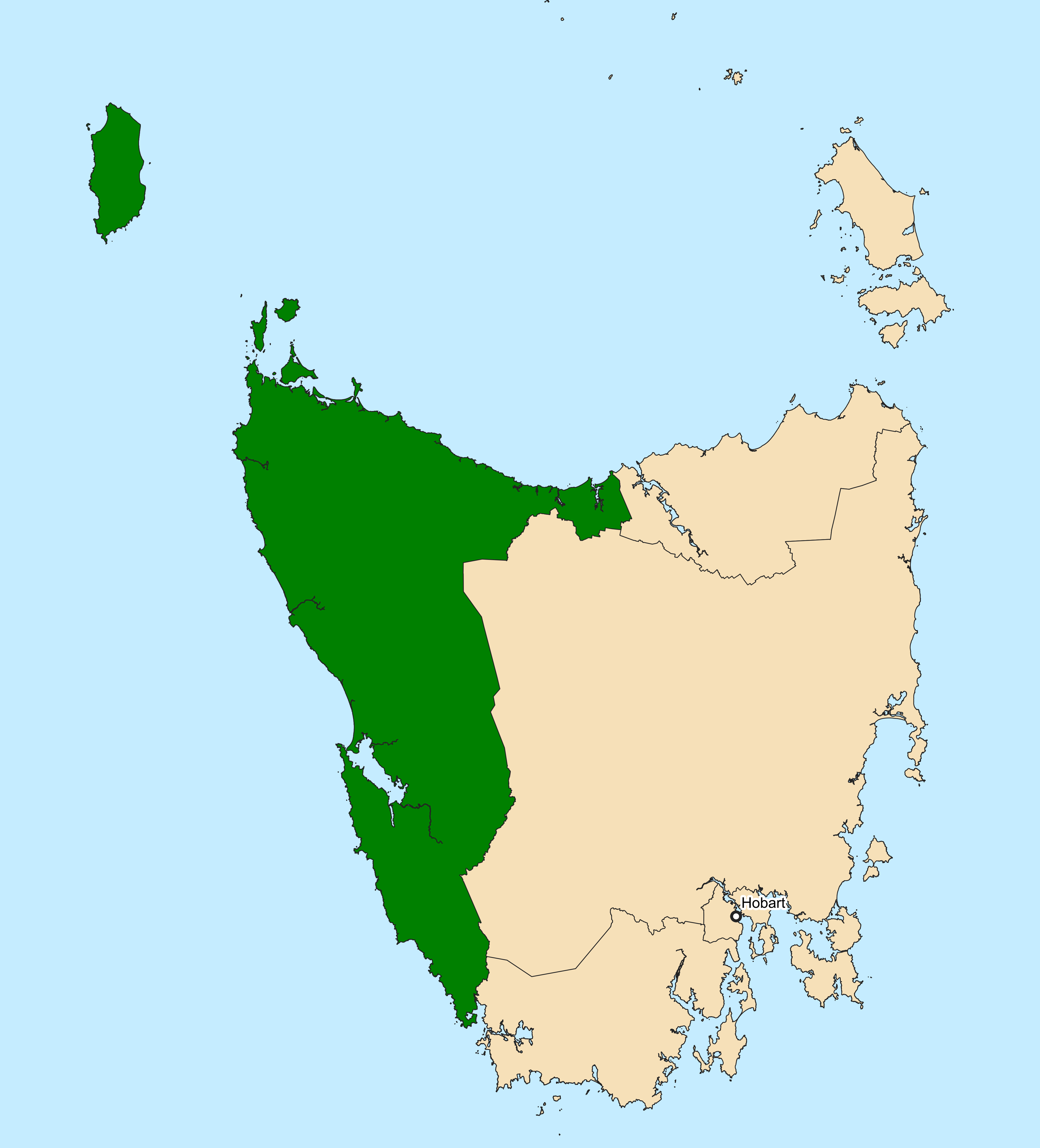
The electoral division of Braddon (named Darwin until 1955) is one of the Tasmanian House of Assembly electoral divisions, five electorates in the Tasmanian House of Assembly, it includes North West Tasmania, north-west and western Tasmania as well as King Island (Tasmania), King Island. Braddon takes its name from the former Premier of Tasmania, Edward Braddon, Sir Edward Braddon. The division shares its name and boundaries with the Division of Braddon, federal division of Braddon. Braddon and the other House of Assembly electoral divisions are each represented by seven members elected under the Hare-Clark electoral system. History and electoral profile Prior to 1955, the electorate was known as Darwin. The electoral constituency includes; King Island (Tasmania), King Island, the North-west towns of Devonport, Tasmania, Devonport, Burnie, Tasmania, Burnie, Wynyard, Tasmania, Wynyard, Ulverstone, Tasmania, Ulverstone, Penguin, Tasmania, Penguin, and Smithton, Tasmania, Smitht ... [...More Info...] [...Related Items...] OR: [Wikipedia] [Google] [Baidu] |


