|
Polissya
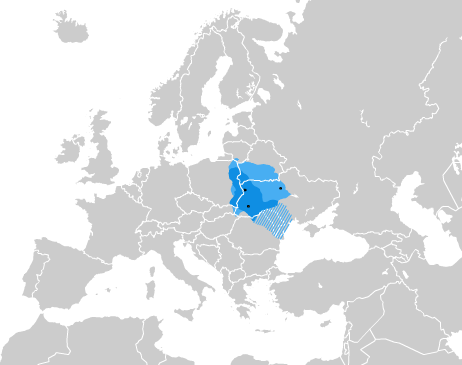
Polesia, also called Polissia, Polesie, or Polesye, is a natural (geographic) and historical region in Eastern Europe within the East European Plain, including the Belarus–Ukraine border region and part of eastern Poland. This region should not be confused with parts of Russia also traditionally called "Polesie". Extent One of the largest forest areas on the continent, Polesia is located in the southwestern part of the Eastern-European Lowland, the Polesian Lowland. On the western side, Polesia includes the crossing of the Bug River valley in Poland and the Pripyat River valley of Western Ukraine. The westernmost part of the region, located in Poland and around Brest, Belarus, historically also formed part of the historic region of Podlachia, and is also referred to as such. The modern Polish part was not considered part of Polesia by the late 19th-century ''Geographical Dictionary of the Kingdom of Poland'', which defined the region as roughly a triangle between the ci ... [...More Info...] [...Related Items...] OR: [Wikipedia] [Google] [Baidu] |
Polesian Lowland
The Polesian Lowland is a lowland in the southwestern portion of the East European Plain in the drainage basins of several rivers including the Dnieper, Pripyat and Desna. It stretches along the Belarus–Ukraine border. It basically defines the historical region of Polesia. It is politically split into the in the south of Belarus, in the north of Ukraine (where Волинське, Рівненське, Житомирське, Київське Полісся are distinguished), the eastern part of the lowland extends into Bryansk Oblast in the Russian Federation, and the western part extends into Poland. Geography The lowland has an area of . The Polesian Lowland is characterised by predominance of sandy lowlands with large, mostly swampy valleys. Its average elevation is , while its maximum elevation is (Ovruch Ridge). Most of the lowland is located in the Pripyat River Valley. The lowland borders the Dnieper and Volyn Uplands in the south, the Western Bug River Valley in ... [...More Info...] [...Related Items...] OR: [Wikipedia] [Google] [Baidu] |
Homel
Gomel (, ) or Homyel (, ) is a city in south-eastern Belarus. It serves as the administrative centre of Gomel Region and Gomel District, though it is administratively separated from the district. As of 2025, it is the second-largest city in Belarus, with 501,193 inhabitants. Etymology There are at least six narratives of the origin of the city's name. The most plausible is that the name is derived from the name of the stream Homeyuk, which flowed into the river Sozh near the foot of the hill where the first settlement was founded. Names of other Belarusian cities are formed along these lines: for example, Polotsk from the river Palata, and Vitebsk from the river Vitsba. The first appearance of the name, as "Gomy", dates from 1142. Up to the 16th century, the city was mentioned as Hom', Homye, Homiy, Homey, or Homyi. These forms are tentatively explained as derivatives of unattested ''*gomŭ'' of uncertain meaning. The modern name for the city has been in use only since the ... [...More Info...] [...Related Items...] OR: [Wikipedia] [Google] [Baidu] |
Belarus–Ukraine Border
The Belarusian-Ukrainian border (, ) is the state border between Belarus and Ukraine with a length of about . It starts from the triple junction with Poland to the west and stretches to the triple junction with Russia to the east. The tripoint border at the triple border junction of Belarus, Russia and Ukraine is marked in the form of a monument, while at the other border junction there is a river, the Western Bug that coincides with the Borders of Poland, border of Poland. Geography The border is situated in the Polesian Lowland, which stretches approximately from the Western Bug to the Dnieper along the Pripyat (river), Pripyat River. The western end of the border starts at the Western Bug, around the area of the Shatsky Lakes, and runs eastward across the Pripet Marshes, Pinsk Marshes. Further along, it stretches parallel to the south of the Pripyat River, passing densely wooded areas that were contaminated after the Chernobyl disaster. The border passes just to the north o ... [...More Info...] [...Related Items...] OR: [Wikipedia] [Google] [Baidu] |
Ubort River
The Ubort (Russian and Ukrainian: Уборть; , ''Ubarć'') is a river in Zhytomyr Oblast (Ukraine) and Gomel Region (Belarus), a right tributary to the Pripyat in the Dnieper river basin. It is long, and has a drainage basin of . The Ubort is fed mostly by melting snow (~70%) and peaks during the spring run-off, usually mid-March to early May, and maintains an even, albeit lower, flow during the summer months. It can freeze as early as mid-November or as late as January, and the ice breaks up as early as mid-February or as late as mid-April. Course The Ubort originates in the hills above and south of the village of Andreyevichi in Zhytomyr Oblast. It arises at elevation 207 m., from a series of small creeks flowing westward off of the Simony Hills, elevation 222 m, and northeastward off of the Marynivka Hills, elevation 225 m. The river flows north past Yemilchyne and Olevsk, thence across the international border into Belarus near Borovoye (Баравое). It then flows ... [...More Info...] [...Related Items...] OR: [Wikipedia] [Google] [Baidu] |
Pripet Marshes
__NOTOC__ The Pripet Marshes or Pripyat Marshes (), also known as Pinsk Marshes (), the Polesie Marshes, and the Rokitno Marshes, are a vast natural region of wetlands in Polesia, along the forested basin of the Pripyat River and its tributaries from Brest to the west, Mogilev in the northeast, and Kyiv to the southeast. Most of the region is in Belarus, and part is in Ukraine. The Pripet Marshes are the largest wetland area in Europe. Overview The Pripet Marshes mostly lie within the Polesian Lowland, hence Polesie Marshes (Woodland Marshes), and occupy most of the southern part of Belarus and the north-west of Ukraine. They cover roughly surrounding the sandy lowlands of the dense network of rivers and rivulets forming on both sides of the Pripyat River, one of the main tributaries of the Dnieper.Pripet Marshes |
Podlachia
Podlachia, also known by its Polish name Podlasie (; ; ), is a historical region in north-eastern Poland. Its largest city is Białystok, whereas the historical capital is Drohiczyn. Similarly to several other historical regions of Poland, e.g. Greater Poland, Lesser Poland, Mazovia, Pomerania, Silesia, Warmia, Podlachia possesses its own folk costumes, unique traditional architecture and cuisine. Between 1513 and 1795 it was a voivodeship with the capital in Drohiczyn. Now the part north of the Bug River is included in the modern Podlaskie Voivodeship with the capital in Białystok, whereas southern parts are located in the Masovian and Lublin Voivodeships. Names and etymology The region is called , or in Polish, in Lithuanian, ''Padliašša'' (Падляшша) in Belarusian, ''Podljas’e'' (Подлясье) in Russian, פּאָדליאַשע ''Podlyashe'' in Yiddish, and in Latin. There are two hypotheses regarding the origin of the name of the region. Accord ... [...More Info...] [...Related Items...] OR: [Wikipedia] [Google] [Baidu] |
Geographical Dictionary Of The Kingdom Of Poland
The Geographical Dictionary of the Kingdom of Poland and other Slavic Countries () is a monumental Polish gazetteer, published 1880–1902 in Warsaw Warsaw, officially the Capital City of Warsaw, is the capital and List of cities and towns in Poland, largest city of Poland. The metropolis stands on the Vistula, River Vistula in east-central Poland. Its population is officially estimated at ... by Filip Sulimierski, Bronisław Chlebowski, Władysław Walewski, and others. External links Słownik geograficzny Królestwa Polskiego* Alphabetic index DjVu format with a search engineAn index for a DjVu browser Gazetteers Encyclopedias in Polish Historical geography of Poland History books about Poland 1880 books 19th-century encyclopedias 20th-century encyclopedias {{poland-book-stub ... [...More Info...] [...Related Items...] OR: [Wikipedia] [Google] [Baidu] |
Mogilev
Mogilev (; , ), also transliterated as Mahilyow (, ), is a city in eastern Belarus. It is located on the Dnieper, Dnieper River, about from the Belarus–Russia border, border with Russia's Smolensk Oblast and from Bryansk Oblast. As of 2024, it has a population of 353,110. In 2011, its population was 360,918, up from an estimated 106,000 in 1956. It serves as the administrative centre of Mogilev Region, and is the List of cities and largest towns in Belarus, third-largest city in Belarus. History The city was first mentioned in historical records in 1267. From the 14th century, it was part of the Grand Duchy of Lithuania, and since the Union of Lublin (1569), it has been part of the Polish–Lithuanian Commonwealth, where it became known as ''Mohylew''. In the 16th and 17th centuries, the city flourished as one of the main nodes of the east-west and north-south trading routes. In 1577, Grand Duke Stefan Batory granted it Magdeburg law, city rights under Magdeburg law. In 1 ... [...More Info...] [...Related Items...] OR: [Wikipedia] [Google] [Baidu] |
Kyiv
Kyiv, also Kiev, is the capital and most populous List of cities in Ukraine, city of Ukraine. Located in the north-central part of the country, it straddles both sides of the Dnieper, Dnieper River. As of 1 January 2022, its population was 2,952,301, making Kyiv the List of European cities by population within city limits, seventh-most populous city in Europe. Kyiv is an important industrial, scientific, educational, and cultural center. It is home to many High tech, high-tech industries, higher education institutions, and historical landmarks. The city has an extensive system of Transport in Kyiv, public transport and infrastructure, including the Kyiv Metro. The city's name is said to derive from the name of Kyi, one of its four legendary founders. During History of Kyiv, its history, Kyiv, one of the oldest cities in Eastern Europe, passed through several stages of prominence and obscurity. The city probably existed as a commercial center as early as the 5th century. A Slav ... [...More Info...] [...Related Items...] OR: [Wikipedia] [Google] [Baidu] |
Chernobyl Exclusion Zone
The Chernobyl Nuclear Power Plant Zone of Alienation, also called the 30-Kilometre Zone or simply The Zone, was established shortly after the 1986 Chernobyl disaster in the Ukrainian SSR of the Soviet Union. Initially, Soviet authorities declared an exclusion zone spanning a radius around the Chernobyl Nuclear Power Plant, designating the area for evacuations and placing it under military control. Its borders have since been altered to cover a larger area of Ukraine: it includes the northernmost part of Vyshhorod Raion in Kyiv Oblast, and also adjoins the Polesie State Radioecological Reserve in neighbouring Belarus. The Chernobyl exclusion zone is managed by an agency of the State Emergency Service of Ukraine, while the power plant and its sarcophagus and the New Safe Confinement are administered separately. The current area of approximately in Ukraine is where radioactive contamination is the highest, and public access and habitation are accordingly restricted. Other ... [...More Info...] [...Related Items...] OR: [Wikipedia] [Google] [Baidu] |
Chernobyl Disaster
On 26 April 1986, the no. 4 reactor of the Chernobyl Nuclear Power Plant, located near Pripyat, Ukrainian Soviet Socialist Republic, Ukrainian SSR, Soviet Union (now Ukraine), exploded. With dozens of direct casualties, it is one of only two nuclear energy accidents rated at the maximum severity on the International Nuclear Event Scale, the other being the 2011 Fukushima nuclear accident. The response involved more than Chernobyl liquidators, 500,000 personnel and cost an estimated 18billion Soviet ruble, rubles (about $84.5billion USD in 2025). It remains the worst nuclear disaster and the List of disasters by cost, most expensive disaster in history, with an estimated cost of US$700 billion. The disaster occurred while running a test to simulate cooling the reactor during an accident in blackout conditions. The operators carried out the test despite an accidental drop in reactor power, and due to a design issue, attempting to shut down the reactor in those conditio ... [...More Info...] [...Related Items...] OR: [Wikipedia] [Google] [Baidu] |
Western Ukraine
Western Ukraine or West Ukraine (, ) refers to the western territories of Ukraine. There is no universally accepted definition of the territory's boundaries, but the contemporary Ukrainian administrative regions ( oblasts) of Chernivtsi, Ivano-Frankivsk, Lviv, Ternopil and Zakarpattia (which were part of the former Austro-Hungarian Empire) are typically included. In addition, Volyn and Rivne oblasts (parts of the territory annexed from the Polish–Lithuanian Commonwealth during its Third Partition) are also usually included. In modern sources, Khmelnytskyi Oblast is often included because of its geographical, linguistic and cultural association with Western Ukraine, although this can not be confirmed from a historical and political point of view. It includes several historical regions such as Carpathian Ruthenia, Halychyna including Pokuttia (the eastern portion of Eastern Galicia), most of Volhynia, northern Bukovina and the Hertsa region, and Podolia. Western Ukraine ... [...More Info...] [...Related Items...] OR: [Wikipedia] [Google] [Baidu] |


