|
Pocumtuck Ridge Trail
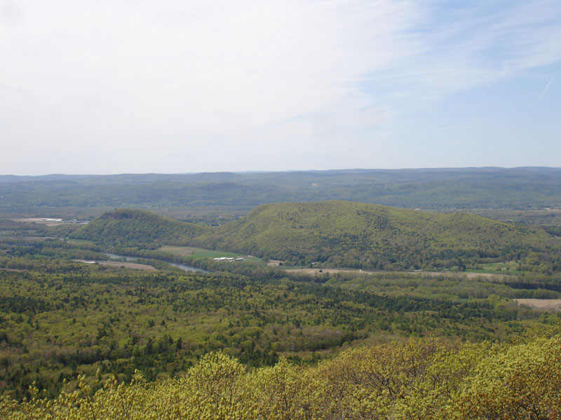
The Pocumtuck Ridge Trail is a footpath that traverses the Pocumtuck Range of Deerfield and Greenfield, Massachusetts. The trail is known for its dramatic views of the Deerfield River and Connecticut River valleys from extensive cliff faces. It traverses the ridgeline from Sugarloaf Mountain, at the southern end of the range, in the Mount Sugarloaf State Reservation Mount Sugarloaf State Reservation is a state-owned, public recreation area managed by the Massachusetts Department of Conservation and Recreation located in South Deerfield, just west of the Connecticut River. The state park includes the summits ..., north over the main ridgeline of Pocumtuck Ridge, to Poet's Seat in Greenfield. Seventy percent of the footway is located on conservation land.''Massachusetts Trail Guide, 8th ed.'' Appalachian Mountain Club, 2004, Boston. As of May 2010, an exception exists approximately one mile north of the east–west crossing high tension power line that is itself north of St ... [...More Info...] [...Related Items...] OR: [Wikipedia] [Google] [Baidu] |
Pocumtuck Range
The Pocumtuck Range, also referred to as the Pocumtuck Ridge, is the northernmost subrange of the Metacomet Ridge mountain range of southern New England. Located in Franklin County, Massachusetts, between the Connecticut River and the Deerfield River valleys, the Pocumtuck Range is a popular hiking destination known for its continuous high cliffs, scenic vistas, and microclimate ecosystems.''Massachusetts Trail Guide, 8th ed.'' Appalachian Mountain Club, 2004, Boston.Farnsworth, Elizabeth J"Metacomet-Mattabesett Trail Natural Resource Assessment.", 2004. PDF file. Cited Nov. 20, 2007Zen, E-an, Goldsmith, Richard, Ratcliffe, N.M., Robinson, Peter, Stanley, R.S., Hatch, N.L., Shride, A.F., Weed, E.G.A., and Wones, D.R. ''Bedrock Geologic Map of Massachusetts'' USGS. 1983 Geography The range, 11 miles (18 km) long by 1.75 miles (2.8 km) wide at its widest point, includes, from south to north, Sugarloaf Mountain of Deerfield; a central high ridge most often called ''Pocum ... [...More Info...] [...Related Items...] OR: [Wikipedia] [Google] [Baidu] |
Deerfield, Massachusetts
Deerfield is a town in Franklin County, Massachusetts, United States. Settled near the Connecticut River in the 17th century during the colonial era, the population was 5,090 as of the 2020 census. Deerfield is part of the Springfield, Massachusetts Metropolitan Statistical Area in western Massachusetts, lying north of the city of Springfield. Deerfield includes the villages of South Deerfield and Old Deerfield, which is home to two museums: Pocumtuck Valley Memorial Association and Historic Deerfield, Inc. Historic Deerfield is designated as a National Historic Landmark district, and the organization operates a museum with a focus on decorative arts, early American material culture, and history. Its eleven house museums offer interpretation of society, history, and culture from the colonial era through the late nineteenth century. The Pocumtuck Valley Memorial Association operates Memorial Hall Museum, which opened in 1880, as well as the Indian House Memorial Children's Mus ... [...More Info...] [...Related Items...] OR: [Wikipedia] [Google] [Baidu] |
Greenfield, Massachusetts
Greenfield is a city in and the county seat of Franklin County, Massachusetts, United States. Greenfield was first settled in 1686. The population was 17,768 at the 2020 census. Greenfield is home to Greenfield Community College, the Pioneer Valley Symphony Orchestra, and the Franklin County Fair. The city has a Main Street Historic District containing fine examples of Federal, Greek Revival, and Victorian architecture. Greenfield is part of the Springfield, Massachusetts, Metropolitan Statistical Area. History Pocumtuck Indians first settled and originally inhabited the Greenfield area. Native American artifacts found in the area have been dated between 7,000 and 9,000 years BCE. The Pocumtucks planted field crops and fished local rivers. Some sources claim that they were wiped out by the Mohawks in 1664 and that the land was left unoccupied. Other sources show that the Pocumtucks joined the Wampanoag chief Metacom in August 1675 in the fight against English encroachment ... [...More Info...] [...Related Items...] OR: [Wikipedia] [Google] [Baidu] |
South Deerfield, MA
South Deerfield is a census-designated place (CDP) in Deerfield, Massachusetts, Deerfield, Franklin County, Massachusetts, United States. It is home to the Yankee Candle Company. At the 2010 census, the population of South Deerfield was 1,880. South Deerfield is part of the Springfield, Massachusetts Springfield metropolitan area, Massachusetts, Metropolitan Statistical Area. History The area was once home to the Pocumtuck tribe, who were driven away by settlers relocated in 1673 from Dedham, Massachusetts, Dedham. In retaliation, on September 18, 1675, the Indigenous peoples of the Americas, Indians attacked and killed Captain Thomas Lathrop and a small force in the Battle of Bloody Brook before being routed by reinforcements. Thereafter called Bloody Brook or Muddy Brook, South Deerfield in 1809 attempted to be set off from Deerfield in part because of the distance to its meetinghouse and in part because of religious differences with its minister, the Reverend Samuel Willard. T ... [...More Info...] [...Related Items...] OR: [Wikipedia] [Google] [Baidu] |
United States
The United States of America (U.S.A. or USA), commonly known as the United States (U.S. or US) or America, is a country primarily located in North America. It consists of 50 U.S. state, states, a Washington, D.C., federal district, five major unincorporated territories, nine United States Minor Outlying Islands, Minor Outlying Islands, and 326 Indian reservations. The United States is also in Compact of Free Association, free association with three Oceania, Pacific Island Sovereign state, sovereign states: the Federated States of Micronesia, the Marshall Islands, and the Palau, Republic of Palau. It is the world's List of countries and dependencies by area, third-largest country by both land and total area. It shares land borders Canada–United States border, with Canada to its north and Mexico–United States border, with Mexico to its south and has maritime borders with the Bahamas, Cuba, Russia, and other nations. With a population of over 333 million, it is the List of ... [...More Info...] [...Related Items...] OR: [Wikipedia] [Google] [Baidu] |
Deerfield River
Deerfield River is a river that runs for from southern Vermont through northwestern Massachusetts to the Connecticut River. The Deerfield River was historically influential in the settlement of western Franklin County, Massachusetts, and its namesake town. It is the Connecticut River's second-longest tributary in Massachusetts, shorter than Metropolitan Springfield's Westfield River. The river's confluence with the Connecticut is in Greenfield, Massachusetts, downstream of Turners Falls (). The Deerfield is one of the most heavily dammed rivers in the country with, on average, a dam almost every for its entire length. In Shelburne Falls, the glacial potholes and the Bridge of Flowers are popular tourist attractions around the river. Geography The great descent of the river of nearly 1,100 feet over 50 miles furnished water power at many places. Several streams nearly as large as the main river enter the Deerfield River from the north. Among its tributaries is the Green ... [...More Info...] [...Related Items...] OR: [Wikipedia] [Google] [Baidu] |
Connecticut River
The Connecticut River is the longest river in the New England region of the United States, flowing roughly southward for through four states. It rises 300 yards (270 m) south of the U.S. border with Quebec, Canada, and discharges at Long Island Sound. Its watershed encompasses , covering parts of five U.S. states and one Canadian province, via 148 tributaries, 38 of which are major rivers. It produces 70% of Long Island Sound's fresh water, discharging at per second. The Connecticut River Valley is home to some of the northeastern United States' most productive farmland, as well as the Hartford–Springfield Knowledge Corridor, a metropolitan region of approximately two million people surrounding Springfield, Massachusetts, and Hartford, Connecticut. History The word "Connecticut" is a corruption of the Mohegan word ''quinetucket'', which means "beside the long, tidal river". The word came into English during the early 1600s to name the river, which was also called simply ... [...More Info...] [...Related Items...] OR: [Wikipedia] [Google] [Baidu] |
Sugarloaf Mountain (Franklin County, Massachusetts)
Sugarloaf Mountain or Mount Sugarloaf, is a butte-like mountain located in South Deerfield, Massachusetts, United States, with two summits, North Sugarloaf Mountain and its more popular knee, South Sugarloaf Mountain . Its cliffs, made of arkose sandstone, are a very prominent landscape feature visible for miles. Despite low elevations relative to the Berkshire Mountains to the west, dramatic cliff faces and a rise of to from the nearby Connecticut River make the mountain a popular tourist and hiking destination. Sugarloaf Mountain is the southern terminus of the Pocumtuck Range. Origin of the name The name ''sugarloaf'' refers to the loaf-like shape that sugar was once molded into for shipment. The names ''Sugarloaf Mountain'' and ''Mount Sugarloaf'' are both used to describe this mountain. USGS sources and published hiking maps refer to (North and South) ''Sugarloaf Mountain''. However, the Massachusetts state reservation encompassing them is called the Mount Sugarloaf ... [...More Info...] [...Related Items...] OR: [Wikipedia] [Google] [Baidu] |
Mount Sugarloaf State Reservation
Mount Sugarloaf State Reservation is a state-owned, public recreation area managed by the Massachusetts Department of Conservation and Recreation located in South Deerfield, just west of the Connecticut River. The state park includes the summits of North Sugarloaf Mountain and South Sugarloaf Mountain, as well as 1.75 miles of frontage on the Connecticut River and two river islands. The park is part of a larger park designation called the Connecticut River Greenway State Park. Portions of the park property along the river are used by the University of Massachusetts Amherst for agricultural research. Activities and amenities The state maintains an automobile road and an observation tower on South Sugarloaf, open from late spring through the fall foliage season. The reservation is accessible via Route 116. Parking for a fee is available at the base of the mountain and at the summit of the auto road. The reservation is open for hiking, picnicking, and scenic viewing. Hiking trails ... [...More Info...] [...Related Items...] OR: [Wikipedia] [Google] [Baidu] |
Protected Areas Of Franklin County, Massachusetts
Protection is any measure taken to guard a thing against damage caused by outside forces. Protection can be provided to physical objects, including organisms, to systems, and to intangible things like civil and political rights. Although the mechanisms for providing protection vary widely, the basic meaning of the term remains the same. This is illustrated by an explanation found in a manual on electrical wiring: Some kind of protection is a characteristic of all life, as living things have evolved at least some protective mechanisms to counter damaging environmental phenomena, such as ultraviolet light. Biological membranes such as bark on trees and skin on animals offer protection from various threats, with skin playing a key role in protecting organisms against pathogens and excessive water loss. Additional structures like scales and hair offer further protection from the elements and from predators, with some animals having features such as spines or camouflage serv ... [...More Info...] [...Related Items...] OR: [Wikipedia] [Google] [Baidu] |
Hiking Trails In Massachusetts
Hiking is a long, vigorous walk, usually on trails or footpaths in the countryside. Walking for pleasure developed in Europe during the eighteenth century.AMATO, JOSEPH A. "Mind over Foot: Romantic Walking and Rambling." In ''On Foot: A History of Walking'', 101-24. NYU Press, 2004. Accessed March 1, 2021. http://www.jstor.org/stable/j.ctt9qg056.7. Religious pilgrimages have existed much longer but they involve walking long distances for a spiritual purpose associated with specific religions. "Hiking" is the preferred term in Canada and the United States; the term "walking" is used in these regions for shorter, particularly urban walks. In the United Kingdom and the Republic of Ireland, the word "walking" describes all forms of walking, whether it is a walk in the park or backpacking in the Alps. The word hiking is also often used in the UK, along with rambling , hillwalking, and fell walking (a term mostly used for hillwalking in northern England). The term bushwalking is ende ... [...More Info...] [...Related Items...] OR: [Wikipedia] [Google] [Baidu] |


