|
Pocumtuck Ridge
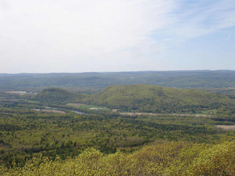
The Pocumtuck Range, also referred to as the Pocumtuck Ridge, is the northernmost subrange of the Metacomet Ridge mountain range of southern New England, itself a subrange of the Appalachian Mountains. Located in Franklin County, Massachusetts, between the Connecticut River and the Deerfield River valleys, the Pocumtuck Range is a popular hiking destination known for its continuous high cliffs, scenic vistas, and microclimate ecosystems.''Massachusetts Trail Guide, 8th ed.'' Appalachian Mountain Club, 2004, Boston.Farnsworth, Elizabeth J"Metacomet-Mattabesett Trail Natural Resource Assessment.", 2004. PDF file. Cited Nov. 20, 2007Zen, E-an, Goldsmith, Richard, Ratcliffe, N.M., Robinson, Peter, Stanley, R.S., Hatch, N.L., Shride, A.F., Weed, E.G.A., and Wones, D.R. ''Bedrock Geologic Map of Massachusetts'' USGS. 1983 Geography The range, 11 miles (18 km) long by 1.75 miles (2.8 km) wide at its widest point, includes, from south to north, Sugarloaf Mountain of Deerfield; ... [...More Info...] [...Related Items...] OR: [Wikipedia] [Google] [Baidu] |
Metacomet Ridge
The Metacomet Ridge, Metacomet Ridge Mountains, or Metacomet Range of southern New England is a narrow and steep fault-block mountain ridge known for its extensive cliff faces, scenic vistas, microclimate ecosystems, and rare or endangered plants. The ridge is an important recreation resource located within of more than 1.5 million people, offering four long-distance hiking trails and over a dozen parks and recreation areas, including several historic sites. It has been the focus of ongoing conservation efforts because of its natural, historic, and recreational value, involving municipal, state, and national agencies and nearly two dozen non-profit organizations.United States Census Bureau Data retrieved December 20, 2007. The Metacomet Ridge extends from |
I-91
Interstate 91 (I-91) is an Interstate Highway System, Interstate Highway in the New England region of the United States. It is the primary north–south thoroughfare in the western part of the region. Its southern terminus is in New Haven, Connecticut, at Interstate 95, I-95, while the northern terminus is in Derby Line, Vermont, at the Canada–United States border. Past the Derby Line–Rock Island Border Crossing, the road continues into Canada as Quebec Autoroute 55. I-91 is the longest of three Interstate highways whose entire route is located within the New England states (the other two highways being Interstate 89, I-89 and Interstate 93, I-93) and is also the only primary (two-digit) Interstate Highway in New England to intersect all five of the other highways that run through the region. The largest cities along its route, from south to north, are New Haven, Connecticut; Hartford, Connecticut; Springfield, Massachusetts; Northampton, Massachusetts; Greenfield, Massa ... [...More Info...] [...Related Items...] OR: [Wikipedia] [Google] [Baidu] |
Sleeping Giant (Connecticut)
Sleeping Giant (also known as the Blue Hills and Mount Carmel), (''Hobbomock'' in Quiripi language, Quinnipiac), is a rugged traprock mountain with a high point of , located north of New Haven, Connecticut, New Haven, Connecticut. A prominent landscape feature visible for miles, the Sleeping Giant receives its name from its anthropomorphic resemblance to a slumbering human figure as seen from either the north or south. The Giant is known for its expansive clifftop vistas, rugged topography, and microclimate ecosystems. Most of the Giant is located within Sleeping Giant State Park. The mountain is a popular recreation site: over of hiking trails traverse it including of the Quinnipiac Trail. Quinnipiac University is located at Mount Carmel's foot in Hamden. Geography The Sleeping Giant, long by wide, is located in Hamden, Connecticut, Hamden with its eastern edge falling into Wallingford, Connecticut, Wallingford. The Giant's profile features distinct "head," "chin," "chest, ... [...More Info...] [...Related Items...] OR: [Wikipedia] [Google] [Baidu] |
Beaver
Beavers (genus ''Castor'') are large, semiaquatic rodents of the Northern Hemisphere. There are two existing species: the North American beaver (''Castor canadensis'') and the Eurasian beaver (''C. fiber''). Beavers are the second-largest living rodents, after capybaras, weighing up to . They have stout bodies with large heads, long chisel-like incisors, brown or gray fur, hand-like front feet, webbed back feet, and tails that are flat and scaly. The two species differ in skull and tail shape and fur color. Beavers can be found in a number of freshwater habitats, such as rivers, streams, lakes and ponds. They are herbivorous, consuming tree bark, aquatic plants, grasses and sedges. Beavers build dams and lodges using tree branches, vegetation, rocks and mud; they chew down trees for building material. Dams restrict water flow, forming ponds, and lodges (usually built in ponds) serve as shelters. Their infrastructure creates wetlands used by many other species, a ... [...More Info...] [...Related Items...] OR: [Wikipedia] [Google] [Baidu] |
Native Americans (United States)
Native Americans (also called American Indians, First Americans, or Indigenous Americans) are the Indigenous peoples of the United States, particularly of the lower 48 states and Alaska. They may also include any Americans whose origins lie in any of the indigenous peoples of North or South America. The United States Census Bureau publishes data about "American Indians and Alaska Natives", whom it defines as anyone "having origins in any of the original peoples of North and South America ... and who maintains tribal affiliation or community attachment". The census does not, however, enumerate "Native Americans" as such, noting that the latter term can encompass a broader set of groups, e.g. Native Hawaiians, which it tabulates separately. The European colonization of the Americas from 1492 resulted in a precipitous decline in the size of the Native American population because of newly introduced diseases, including weaponized diseases and biological warfare by colonizers, ... [...More Info...] [...Related Items...] OR: [Wikipedia] [Google] [Baidu] |
Pocumtuc
The Pocomtuc (also Pocomtuck, Pocumtuc, Pocumtuck, or Deerfield Indians) were a Native American tribe historically inhabiting western areas of Massachusetts. Settlements Their territory was concentrated around the confluence of the Deerfield and Connecticut Rivers in today's Franklin County. Their homelands also included much of current-day Hampden and Hampshire Counties, plus areas now in northern Connecticut and southern Vermont. Their principal village, also known as Pocumtuck, was in the vicinity of the present day village of Deerfield, Massachusetts. Language Their language, now extinct, was an R-dialect of the Algonquian language family, most likely related to the Wappinger and nearby Mahican tribes of the Hudson River Valley.Swanton, John R. ''The Indian Tribes of North America'', pp. 23-24. Smithsonian Institution Bureau of American Ethnology Bulletin 145. Washington DC.: Government Printing Office, 1952. Subsistence The Pocumtuc people likely led lifestyles ... [...More Info...] [...Related Items...] OR: [Wikipedia] [Google] [Baidu] |
Mount Tom Range
The Mount Tom Range is a traprock mountain range located in the Connecticut River Valley of Massachusetts. It is a subrange of the Appalachians and part of the Metacomet Ridge that extends from Long Island Sound near New Haven, Connecticut, north through the Connecticut River Valley of Massachusetts to nearly the Vermont border. A popular outdoor recreation resource, the range is known for its continuous west facing cliffs and its rugged, scenic character. It is also notable for its unique microclimate ecosystems and rare plant communities, as well as significant historic sites, such as the ruins of the 18th century Eyrie House located on Mount Nonotuck.*''The Metacomet-Monadnock Trail Guide''. 9th Edition. The Appalachian Mountain Club. Amherst, Massachusetts, 1999.Farnsworth, ElizabethJ.Metacomet-Mattabesett Trail Natural Resource Assessment." 2004. PDF file cited November 1, 2007. Geography The Mount Tom Range rises steeply between above the Connecticut River Valley bel ... [...More Info...] [...Related Items...] OR: [Wikipedia] [Google] [Baidu] |
Holyoke Range
The Holyoke Range or Mount Holyoke Range is a traprock mountain range located in the Connecticut River Valley of Massachusetts. It is a subrange of the narrow, linear Metacomet Ridge that extends from Long Island Sound near New Haven, Connecticut, north through the Connecticut River Valley of Massachusetts to the Vermont border. It is also a subrange of the Appalachian Mountains. A popular hiking destination, the range is known for its anomalous east–west orientation, high ledges and its scenic character. It is also notable for its unique microclimate ecosystems and rare plant communities, as well as significant historic sites, such as the Mount Holyoke Summit House and the Horse Caves.Farnsworth, Elizabeth J"Metacomet-Mattabesett Trail Natural Resource Assessment." (2004). PDF file. Retrieved November 20, 2007. Retrieved December 10, 2007
|
Northfield, Massachusetts
Northfield is a town in Franklin County, Massachusetts, United States. Northfield was first settled in 1673. The population was 2,866 at the 2020 census. It is part of the Springfield, Massachusetts Metropolitan Statistical Area. The Connecticut River runs through the town, dividing West Northfield from East Northfield and the village of Northfield, where the town hall is located. Part of the town is included in the census-designated place of Northfield. History The village of Skakeat/Squakheag was the site of modern-day Northfield and was home to the Nashaway Nipmuc and Sokoki Abenaki. Northfield was first colonized by European settlers in 1673 and was officially incorporated in 1723. ''Indian Land Deeds for Hampshire County, Including Later Berkshire, Franklin, and Hampden Counties,'' gives the name of the otan (village) as Squakheag (a Nipmuk name), also Skakeat (Sokoki Abenaki). John Eliot, in his ''Brief Narrative...History of the Nipmuk,'' attributes this village ... [...More Info...] [...Related Items...] OR: [Wikipedia] [Google] [Baidu] |
New Hampshire
New Hampshire ( ) is a U.S. state, state in the New England region of the Northeastern United States. It borders Massachusetts to the south, Vermont to the west, Maine and the Gulf of Maine to the east, and the Canadian province of Quebec to the north. Of the List of states and territories of the United States, 50 U.S. states, New Hampshire is the List of U.S. states and territories by area, seventh-smallest by land area and the List of U.S. states and territories by population, tenth-least populous, with a population of 1,377,529 residents as of the 2020 United States census, 2020 census. Concord, New Hampshire, Concord is the List of capitals in the United States, state capital and Manchester, New Hampshire, Manchester is the List of municipalities in New Hampshire, most populous city. New Hampshire's List of U.S. state mottos, motto, "Live Free or Die", reflects its role in the American Revolutionary War; its state nickname, nickname, "The Granite State", refers to its ext ... [...More Info...] [...Related Items...] OR: [Wikipedia] [Google] [Baidu] |
Vermont
Vermont () is a U.S. state, state in the New England region of the Northeastern United States. It borders Massachusetts to the south, New Hampshire to the east, New York (state), New York to the west, and the Provinces and territories of Canada, Canadian province of Quebec to the north. According to the most recent U.S. Census estimates, the state has an estimated population of 648,493, making it the List of U.S. states and territories by population, second-least populated of all U.S. states. It is the nation's List of U.S. states and territories by area, sixth smallest state in area. The state's capital of Montpelier, Vermont, Montpelier is the least populous List of capitals in the United States, U.S. state capital. No other U.S. state has a List of largest cities of U.S. states and territories by population, most populous city with fewer residents than Burlington, Vermont, Burlington. Native Americans in the United States, Native Americans have inhabited the area for abou ... [...More Info...] [...Related Items...] OR: [Wikipedia] [Google] [Baidu] |


