|
Pivot Peak
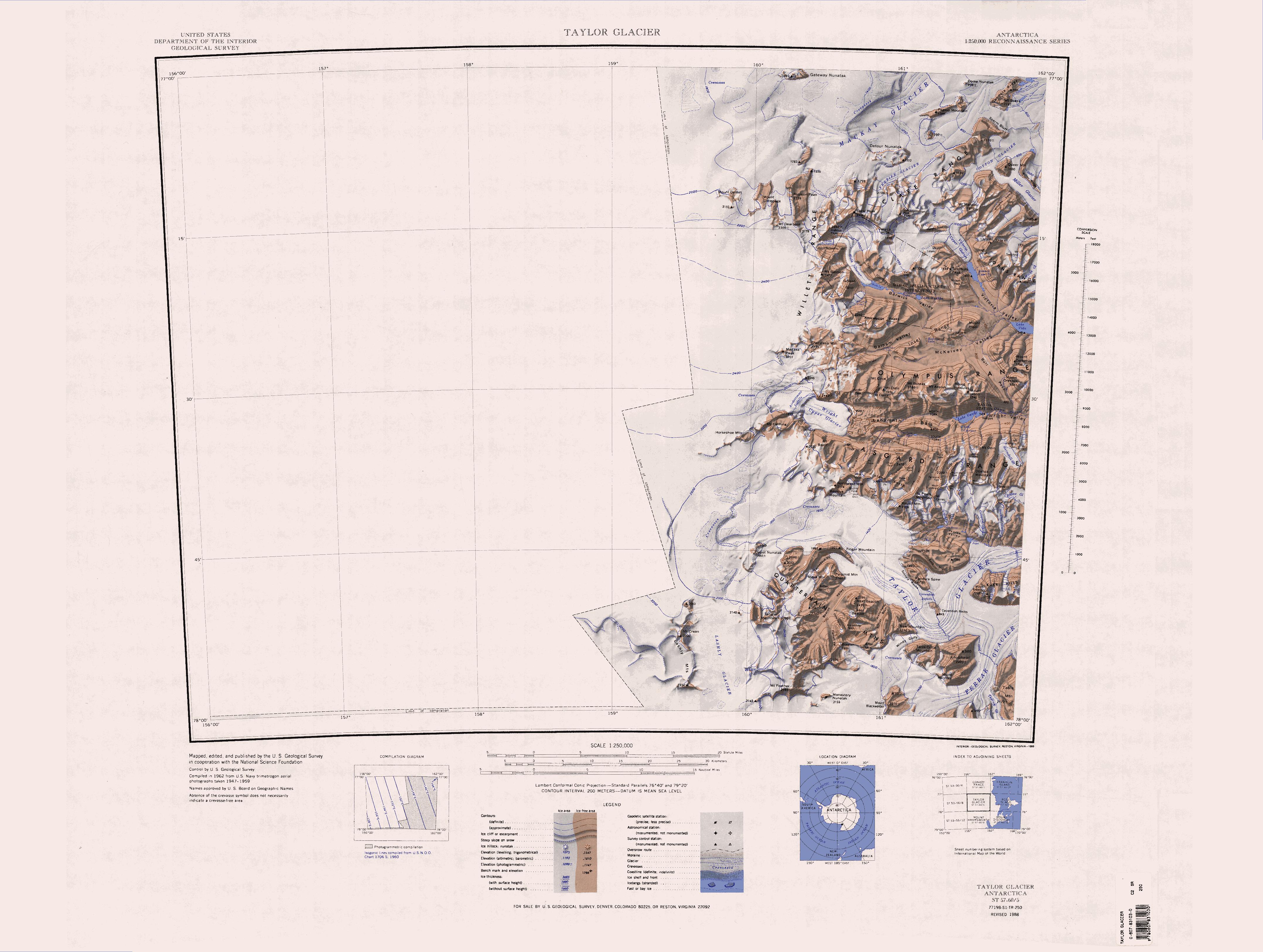
The Wilkniss Mountains () form a prominent group of conical peaks and mountains, long running north–south, located east-southeast of Mount Feather in the Quartermain Mountains, Victoria Land, Antarctica. The mountains are wide in the north portion where Mount Blackwelder, high, and Pivot Peak high, rise above ice-free valleys. Except for an outlying southwest peak, the south portion narrows to a series of mainly ice-covered smaller peaks. Name The Wilkniss Mountains were named by United States Advisory Committee on Antarctic Names (US-ACAN) in 1992 after Peter E. Wilkniss, a chemist who from 1975 has served in various positions at the National Science Foundation, including Deputy Assistant Director of the Directorate for Scientific, Technological, and International Affairs; Director, Division of Polar Programs, 1984–93; senior science associate to the assistant director for Geosciences, from 1993. Location The Wilkniss Mountains are south of the Knobhead massif, the ... [...More Info...] [...Related Items...] OR: [Wikipedia] [Google] [Baidu] |
Antarctica
Antarctica () is Earth's southernmost and least-populated continent. Situated almost entirely south of the Antarctic Circle and surrounded by the Southern Ocean (also known as the Antarctic Ocean), it contains the geographic South Pole. Antarctica is the fifth-largest continent, being about 40% larger than Europe, and has an area of . Most of Antarctica is covered by the Antarctic ice sheet, with an average thickness of . Antarctica is, on average, the coldest, driest, and windiest of the continents, and it has the highest average elevation. It is mainly a polar desert, with annual Climate of Antarctica#Precipitation, precipitation of over along the coast and far less inland. About 70% of the world's freshwater reserves are frozen in Antarctica, which, if melted, would raise global sea levels by almost . Antarctica holds the record for the Lowest temperature recorded on Earth, lowest measured temperature on Earth, . The coastal regions can reach temperatures over in the ... [...More Info...] [...Related Items...] OR: [Wikipedia] [Google] [Baidu] |
Skelton Glacier
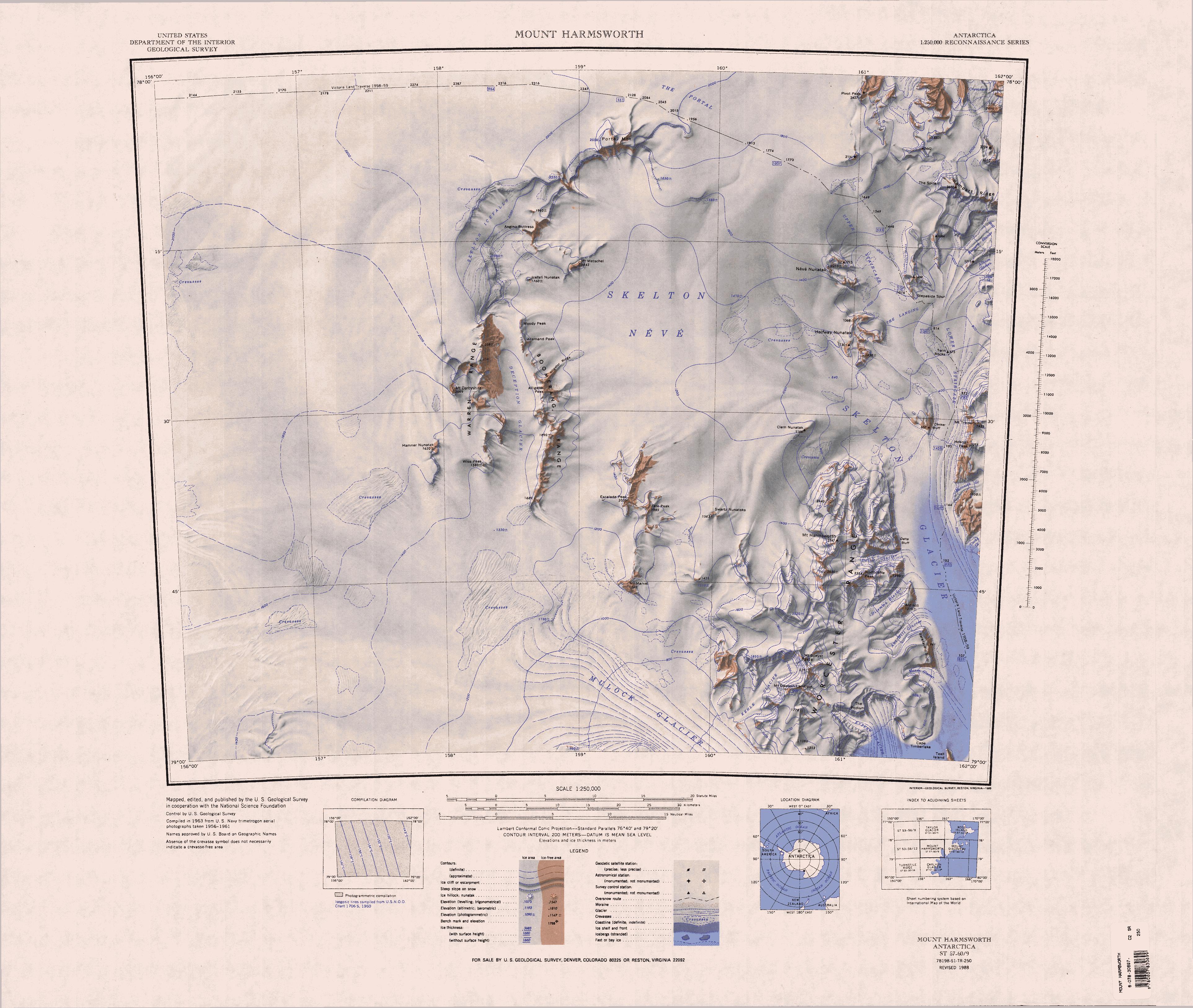
Skelton Glacier () is a large glacier flowing from the polar plateau into the Ross Ice Shelf at Skelton Inlet on the Hillary Coast, south of Victoria Land, Antarctica. Naming and exploration Skelton Glacier was named after the Skelton Inlet by the New Zealand party of the Commonwealth Trans-Antarctic Expedition (CTAE), 1956–58. The glacier was chosen in 1957 as the New Zealand party's route from the Ross Ice Shelf to the Antarctic Plateau. The Arctic Institute of North America organized two ground traverses in the antarctic summer of 1959–60 sponsored by the United States Antarctic Research Program. The first left New Zealand's Scott Base on 16 October 1959, crossed part of the Ross Ice Shelf, and on 27 October 1959 reached the foot of the Skelton Glacier. They traversed up the heavily crevassed glacier to a fuel cache deposited on the edge of the Victoria Land plateau by planes of the United States Navy and Air Force. From there they travelled more than to the end station ... [...More Info...] [...Related Items...] OR: [Wikipedia] [Google] [Baidu] |
McMurdo Dry Valleys
The McMurdo Dry Valleys are a row of largely Antarctic oasis, snow-free valleys in Antarctica, located within Victoria Land west of McMurdo Sound. The Dry Valleys experience extremely low humidity and surrounding mountains prevent the flow of ice from nearby glaciers. The rocks there are granites and gneisses, and glacial tills dot this bedrock landscape, with loose gravel covering the ground. It is one of the driest places on Earth, though there are several anecdotal accounts of rainfall within the Dry Valleys. The region is one of the world's most extreme deserts, and includes many features including Lake Vida, a saline lake, and the Onyx River, a meltwater stream and Antarctica's longest river. Although no living organisms have been found in the permafrost here, Endolithic lichen, endolithic Photosynthesis, photosynthetic bacteria have been found living in the relatively moist interior of rocks, and anaerobic bacteria, with a metabolism based on iron and sulfur, live under ... [...More Info...] [...Related Items...] OR: [Wikipedia] [Google] [Baidu] |
Terminal Moraine
A terminal moraine, also called an end moraine, is a type of moraine that forms at the terminal (edge) of a glacier, marking its maximum advance. At this point, debris that has accumulated by plucking and abrasion, has been pushed by the front edge of the ice, is driven no further and instead is deposited in an unsorted pile of sediment. Because the glacier acts very much like a conveyor belt, the longer it stays in one place, the greater the amount of material that will be deposited. The moraine is left as the marking point of the terminal extent of the ice. Formation As a glacier moves along its path, the surrounding area is continuously eroding. Loose rock and pieces of bedrock are constantly being picked up and transported with the glacier. Fine sediment and particles are also incorporated into the glacial ice. The accumulation of these rocks and sediment together form what is called glacial till when deposited. Push moraines are formed when a glacier retreats from ... [...More Info...] [...Related Items...] OR: [Wikipedia] [Google] [Baidu] |
Rampart Ridge
Rampart Ridge () is a prominent broken ridge on the west side of the Royal Society Range, Antarctica. It stands north of Rutgers Glacier and extends from The Spire to Bishop Peak. Exploration and name Rampart Ridge was surveyed and given this descriptive name in February 1957 by the New Zealand Northern Survey Party of the Commonwealth Trans-Antarctic Expedition (CTAE), 1956–58. Location Rampart Ridge is to the east of The Portal and the Upper Staircase, in the west of the Royal Society Range. The Spire is at its western extremity. Rutgers Glacier flows west and then southwest past the south of the ridge. Bishop Peak is at the eastern end of the ridge. The Johns Hopkins Ridge is to the east, across the névé of the Rutgers Glacier. Features Features of the ridge include, from west to east: The Spire . A prominent rock spire, over high, surmounting .the west extremity of Rampart Ridge. Surveyed and descriptively named in 1957 by the N.Z. party of the CTAE, 1956-58. ... [...More Info...] [...Related Items...] OR: [Wikipedia] [Google] [Baidu] |
Portal Mountain
The Lashly Mountains () are a small group of mountains, the most prominent at being Mount Crean, standing south of the head of Taylor Glacier and west of Lashly Glacier, in Victoria Land, Antarctica. Exploration and naming The Lashly Mountains were discovered by the British National Antarctic Expedition (1901–04) and named for William Lashly, a member of the party which explored this area. Location The Lashley Mountains are on the edge of the East Antarctic Ice Sheet. They are west of the Quartermain Mountains and Mount Feather, from which they are separated by the Lashly Glacier, which flows south into The Portal. Mount Crean is the highest peak of the range. Portal Mountain lies to the south of the range, above the Skelton Névé. Geology The Lashly Mountains lie between the intrusive rocks of the McMurdo Dry Valleys and the extrusive rocks of the Transantarctic Mountains. Samples from an unnamed nunatak north of Mount Crean indicated an extrusive origin. The Lashl ... [...More Info...] [...Related Items...] OR: [Wikipedia] [Google] [Baidu] |
Palais Glacier
Ferrar Glacier ()is a glacier in Antarctica. It is about long, flowing from the plateau of Victoria Land west of the Royal Society Range to New Harbour (Antarctica), New Harbour in McMurdo Sound. The glacier makes a right (east) turn northeast of Knobhead, where it where it is apposed, i.e., joined in Siamese-twin fashion, to Taylor Glacier. From there, it continues east along the south side of Kukri Hills to New Harbor. Discovery and naming Ferrar Glacier was discovered by the British National Antarctic Expedition, (1901–04) under Captain Robert Falcon Scott, who named this feature for Hartley T. Ferrar, geologist of the expedition. The name Ferrar Glacier was originally applied both to the part of this glacier below its right turn and to the present Taylor Glacier. Thomas Griffith Taylor, geologist of the British Antarctic Expedition, 1910–13, under Scott, found evidence that these are not two parts of a single glacier but are two glaciers apposed. With this discovery Sco ... [...More Info...] [...Related Items...] OR: [Wikipedia] [Google] [Baidu] |
Mount Feather
The Quartermain Mountains ( ) are a group of exposed mountains in Antarctica, about long, typical of ice-free features of the McMurdo Dry Valleys, Victoria Land. They are east of the Lashly Mountains, south of the Asgard Range, west of the Kukri Hills and Royal Society Range, and some distance north of the Worcester Range. Exploration The Quartermain Mountains were visited by British expeditions led by Robert Falcon Scott (1901–04 and 1910–13) and Ernest Shackleton (1907–09), who applied several names. Names were added in the years subsequent to the International Geophysical Year, 1957–58, concurrent with research carried out by New Zealand Antarctic Research Programme (NZARP) and United States Antarctic Research Program (USARP) field parties, and to fulfill the requirement for maps compiled from United States Navy aerial photographs, 1947–83. In 1977, the New Zealand Antarctic Place-Names Committee named the mountains after New Zealand Antarctic historian Lester B ... [...More Info...] [...Related Items...] OR: [Wikipedia] [Google] [Baidu] |
Ferrar Glacier
Ferrar Glacier ()is a glacier in Antarctica. It is about long, flowing from the plateau of Victoria Land west of the Royal Society Range to New Harbour in McMurdo Sound. The glacier makes a right (east) turn northeast of Knobhead, where it where it is apposed, i.e., joined in Siamese-twin fashion, to Taylor Glacier. From there, it continues east along the south side of Kukri Hills to New Harbor. Discovery and naming Ferrar Glacier was discovered by the British National Antarctic Expedition, (1901–04) under Captain Robert Falcon Scott, who named this feature for Hartley T. Ferrar, geologist of the expedition. The name Ferrar Glacier was originally applied both to the part of this glacier below its right turn and to the present Taylor Glacier. Thomas Griffith Taylor, geologist of the British Antarctic Expedition, 1910–13, under Scott, found evidence that these are not two parts of a single glacier but are two glaciers apposed. With this discovery Scott gave the names Ferr ... [...More Info...] [...Related Items...] OR: [Wikipedia] [Google] [Baidu] |
Knobhead
The Quartermain Mountains ( ) are a group of exposed mountains in Antarctica, about long, typical of ice-free features of the McMurdo Dry Valleys, Victoria Land. They are east of the Lashly Mountains, south of the Asgard Range, west of the Kukri Hills and Royal Society Range, and some distance north of the Worcester Range. Exploration The Quartermain Mountains were visited by British expeditions led by Robert Falcon Scott (1901–04 and 1910–13) and Ernest Shackleton (1907–09), who applied several names. Names were added in the years subsequent to the International Geophysical Year, 1957–58, concurrent with research carried out by New Zealand Antarctic Research Programme (NZARP) and United States Antarctic Research Program (USARP) field parties, and to fulfill the requirement for maps compiled from United States Navy aerial photographs, 1947–83. In 1977, the New Zealand Antarctic Place-Names Committee named the mountains after New Zealand Antarctic historian Lester B ... [...More Info...] [...Related Items...] OR: [Wikipedia] [Google] [Baidu] |


