|
Pivdennoukrainsk
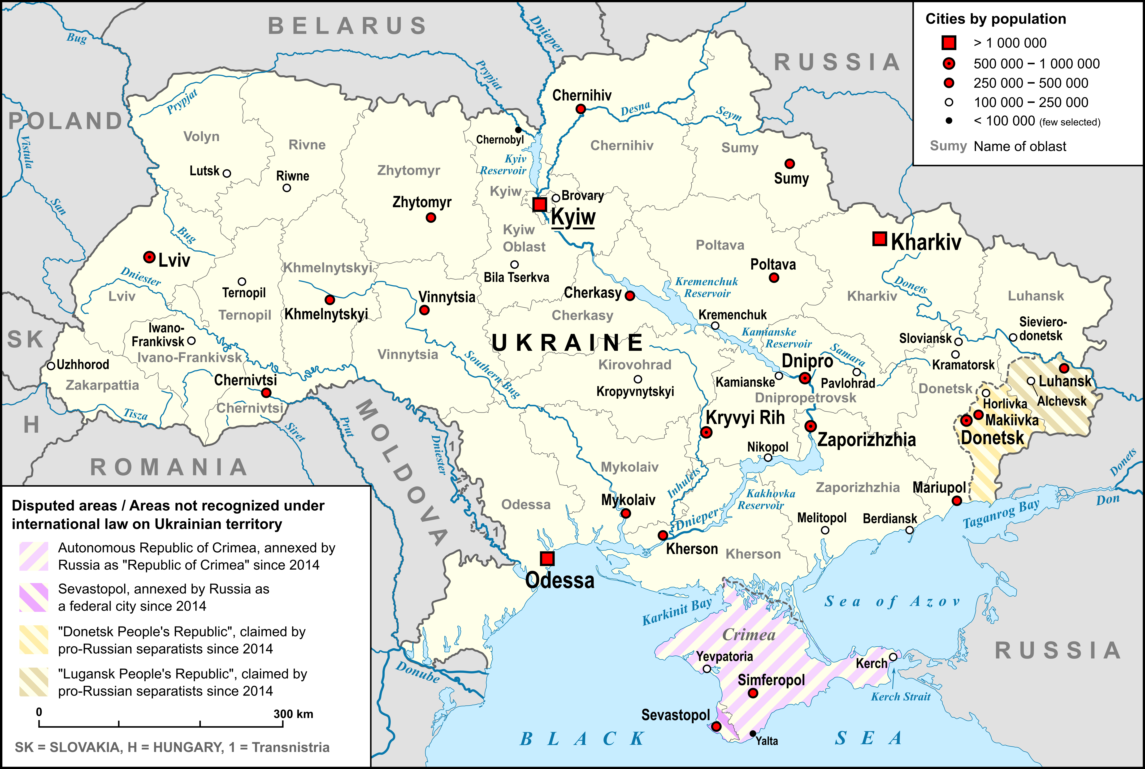
Pivdennoukrainsk (), formerly known as Yuzhnoukrainsk (), is a city on the Southern Bug river, in Voznesensk Raion, Mykolaiv Oblast, Ukraine, about 350 kilometers (over 200 miles) south of the capital Kyiv. It hosts the administration of Pivdennoukrainsk urban hromada, one of the hromadas of Ukraine. Population: Etymology In Ukrainian, the word "" means "South". History Yuzhnoukrainsk was founded in 1976. It is one of the youngest Ukrainian towns. It received city status and the name ''Yuzhnoukrainsk'' on 2 April 1987. Until 18 July 2020, Yuzhnoukrainsk was incorporated as a city of oblast significance. In July 2020, as part of the administrative reform of Ukraine, which reduced the number of raions of Mykolaiv Oblast to four, the city of Yuzhnoukrainsk was merged into Voznesensk Raion. In May 2022, as a result of the Russian invasion of Ukraine that began that year, many Ukrainian cities began removing Russian-derived toponymy. After deliberations, the city council of ... [...More Info...] [...Related Items...] OR: [Wikipedia] [Google] [Baidu] |
South Ukraine Nuclear Power Plant
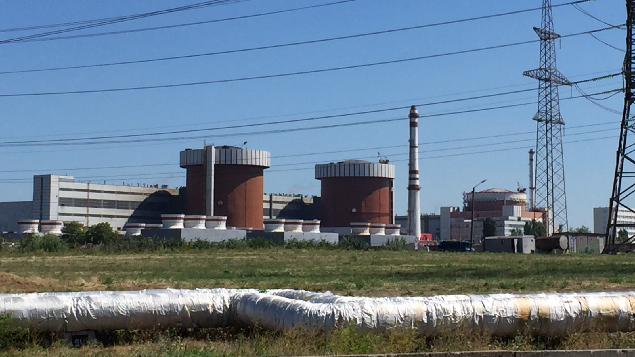
The South Ukraine Nuclear Power Plant (), also known as the Pivdennoukrainsk Nuclear Power Plant, is a nuclear power plant in Ukraine, near the city of Pivdennoukrainsk in Mykolaiv Oblast, about south of Kyiv. It is the second largest of the country's five nuclear power stations. It is part of the South Ukrainian Energy Complex, along with the Tashlyk Pumped-Storage Power Plant and Oleksandrivka, Oleksandrivka settlement hromada, Voznesensk Raion, Mykolaiv Oblast, Oleksandrivska hydroelectric power station. It has three VVER-1000 pressurized water reactors and a net generation capacity of 2,850 megawatts (MW). In 2013, following major upgrade work, unit 1 was given a 10-year license extension, which will take it beyond its original 30-year design lifetime. Similar extensions are planned for units 2 and 3, licensed until 2015 and 2019, respectively. The Vetrino–Isaccea–Yuzhnoukrainsk powerline runs from the plant to Isaccea, Romania, but is mostly dismantled or ruined. H ... [...More Info...] [...Related Items...] OR: [Wikipedia] [Google] [Baidu] |
Mykolaiv Oblast
Mykolaiv Oblast (, ), also referred to as Mykolaivshchyna (, ), is an administrative divisions of Ukraine, oblast (province) of Ukraine. The administrative center of the oblast is the city of Mykolaiv. At the most recent estimate, the population of the oblast stood at History Historically, at various times, the territory was ruled either entirely or partly by Scythia, ancient Greeks, Old Great Bulgaria, Khazars, Kipchaks, the Mongol Empire, Grand Duchy of Lithuania, Lithuania, the Crimean Khanate, the Ottoman Empire, Crown of the Kingdom of Poland, Poland, and Russian Empire, Russia. Historic cities of greatest importance were ancient Pontic Olbia, Olbia and the late medieval port city of Ochakiv. In the late 17th and 18th centuries the tripoint of three List of modern great powers, early modern great powers, the Polish–Lithuanian Commonwealth, the Ottoman Empire and Russia, was located at the site of Pervomaisk, Mykolaiv Oblast, Pervomaisk, the current second-largest city of ... [...More Info...] [...Related Items...] OR: [Wikipedia] [Google] [Baidu] |
Tashlyk Pumped-Storage Power Plant
Tashlyk Pumped-Storage Power Plant () is a pumped-storage power station near Pivdennoukrainsk in Mykolaiv Oblast, Ukraine. It connects with Oleksandrivka, Oleksandrivka settlement hromada, Voznesensk Raion, Mykolaiv Oblast, Oleksandrivka reservoir on the Southern Bug River. The Tashlyk Hydraulic Accumulation Station is located west of the district center of Arbuzynka, three kilometers south of Pivdennoukrainsk. History Tashlyk Pumped-Storage Power Plant is part of the South-Ukrainian Energy Complex, which includes the South Ukraine Nuclear Power Plant and Oleksandrivka, Oleksandrivka settlement hromada, Voznesensk Raion, Mykolaiv Oblast, Oleksandrivka hydroelectric power station. The pumped-storage plant is designed to cover peak loads in the southwestern part of the united power grid of Ukraine, and to provide a reliable baseline regime for the nuclear plant. Construction of the station began in 1981. In the original plans, the Tashlyk HPSP was to consist of six rotary (gene ... [...More Info...] [...Related Items...] OR: [Wikipedia] [Google] [Baidu] |
Voznesensk Raion
Voznesensk Raion () is a raion (district) in Mykolaiv Oblast, Ukraine. Its administrative center is the town of Voznesensk. Population: History In 1923, uyezds in Ukrainian Soviet Socialist Republic were abolished, and the governorates were divided into okruhas. In 1923, Voznesensk Raion with the administrative center located in Voznesensk was established. It belonged to Mykolaiv Okruha of Odessa Governorate. In 1925, the governorates were abolished, and okruhas were directly subordinated to Ukrainian SSR. In 1930, okruhas were abolished, and on 27 February 1932, Odessa Oblast was established, and Voznesensk Raion was included into Odessa Oblast. In 1944, Voznesensk Raion was transferred to Mykolaiv Oblast. In 1975, Voznesensk became the city of oblast significance. On 18 July 2020, as part of the administrative reform of Ukraine, the number of raions of Mykolaiv Oblast was reduced to four, and the area of Voznesensk Raion was significantly expanded. Four abolished raions, Br ... [...More Info...] [...Related Items...] OR: [Wikipedia] [Google] [Baidu] |
List Of Cities In Ukraine
There are 463 populated places in Ukraine, populated places in Ukraine that have been officially granted city status () by the Verkhovna Rada, the country's parliament, as of 23 April 2025. Settlements with more than 10,000 people are eligible for city status although the status is typically also granted to settlements of historical or regional importance. Smaller settlements are Populated places in Ukraine#Rural settlements, rural settlements () and villages (). Historically, there were systems of city rights, granted by the territorial lords, which defined the status of a place as a ''misto'' or ''selo''. In the past, cities were self-governing and had several privileges. The list of cities is roughly ordered by population and the 2022 estimates are compared to the 2001 Ukrainian census, except for Chernobyl for which the population is an unofficial estimate. The City with special status, cities with special status are shown in ''italic''. The average population size is 62,000. ... [...More Info...] [...Related Items...] OR: [Wikipedia] [Google] [Baidu] |
On The Condemnation And Prohibition Of Propaganda Of Russian Imperial Policy In Ukraine And The Decolonization Of Toponymy
The Law of Ukraine "On the Condemnation and Prohibition of Propaganda of Russian Imperial Policy in Ukraine and the Decolonization of Toponymy" () is a piece of Ukrainian legislation, enacted by the Verkhovna Rada of Ukraine on March 21, 2023. The law has been widely described as providing a legal framework for the process of the derussification and decolonization of Ukraine, which officially began after the collapse of the Soviet Union in 1991 and considerably intensified after the Russian invasion of Ukraine in 2022. Background The Russian invasion of Ukraine that began in 2022 has increased the rate of derussification in Ukraine, especially the removal of names associated with Russia and Russian imperialism. Ukrainian advocates for the process refer to it as decolonization. Street names associated with Russia were changed in major Ukrainian cities like Lviv, Dnipro, Kyiv, and Kharkiv. Ivano-Frankivsk became the first city to remove all its Russian toponyms altogether. Hist ... [...More Info...] [...Related Items...] OR: [Wikipedia] [Google] [Baidu] |
City Of Regional Significance (Ukraine)
A city of regional significance () in Ukraine was a type of second-level Administrative divisions of Ukraine, administrative division or municipality, the other type being Raions of Ukraine, raions (districts). In the first-level division of Oblasts of Ukraine, oblasts, they were referred to as ''cities of oblast significance''; in the first-level autonomous republic of Autonomous Republic of Crimea, Crimea, they were ''cities of republican significance''. The designation was created with the introduction of oblasts in 1932. It was abolished in a 2020 reform that merged raions together and integrated the city municipalities into them. Such city municipality was complex and usually combined the city proper and adjacent populated places. The city of regional (oblast) significance was governed by a city council known as ''mis'krada'', which was chaired by a mayor. There were instances where a municipality might have included only the city alone (city proper), while in others instanc ... [...More Info...] [...Related Items...] OR: [Wikipedia] [Google] [Baidu] |
Derussification In Ukraine
Derussification in Ukraine () is a process of removing Russian influence from the post-Soviet country of Ukraine. This derussification started after the collapse of the Soviet Union in 1991 and intensified with the demolition of monuments to Lenin during Euromaidan in 2014 and the further systemic process of decommunization in Ukraine. The Russo-Ukrainian War gave a strong impetus to the process. Along with decommunization, derussification has been described as one of the components of a larger process of decolonization in Ukraine. The process manifests itself in the renaming of toponyms named after Russian statesmen and cultural figures, or those that are believed to reflect Russianism and the Russian worldview, or are otherwise associated with Russia. Also part of the process is the dismantling of objects of the Russian rule (e.g., plaques, signs, monuments, busts, and panels). As of April 8, 2022, according to a poll by the sociological group ''Rating'', 76% of Ukrainians su ... [...More Info...] [...Related Items...] OR: [Wikipedia] [Google] [Baidu] |
Southern Bug
The Southern Bug, also called Southern Buh (; ; ; or just ), and sometimes Boh River (; ), at the Encyclopedia of Ukraine is a navigable river located in Ukraine. It is the List of longest rivers of Ukraine, second-longest river flowing exclusively in Ukraine. While located in relatively close proximity, the river should not be confused with Western Bug or Bug which flows in opposite direction towards Baltics. The source of the Southern Bug is in the west of Ukraine, in the Volhynian-Podolian Upland, about from the Polish border, from where it flows southeasterly into the Bug Estuary (Black Sea basin) through the southern steppes (see Granite-steppe lands of Buh park). It is long and drains . [...More Info...] [...Related Items...] OR: [Wikipedia] [Google] [Baidu] |
Postal Code
A postal code (also known locally in various English-speaking countries throughout the world as a postcode, post code, PIN or ZIP Code) is a series of letters or numerical digit, digits or both, sometimes including spaces or punctuation, included in a postal address for the purpose of sorting mail. the Universal Postal Union lists 160 countries which require the use of a postal code. Although postal codes are usually assigned to geographical areas, special codes are sometimes assigned to individual addresses or to institutions that receive large volumes of mail, such as government agencies and large commercial companies. One example is the French Cedex (France), CEDEX system. Terms There are a number of synonyms for postal code; some are country-specific: * Codice di Avviamento Postale, CAP: The standard term in Italy; CAP is an acronym for ('postal expedition code'). * Código de Endereçamento Postal, CEP: The standard term in Brazil; CEP is an acronym for ('postal add ... [...More Info...] [...Related Items...] OR: [Wikipedia] [Google] [Baidu] |
Armenians
Armenians (, ) are an ethnic group indigenous to the Armenian highlands of West Asia.Robert Hewsen, Hewsen, Robert H. "The Geography of Armenia" in ''The Armenian People From Ancient to Modern Times Volume I: The Dynastic Periods: From Antiquity to the Fourteenth Century''. Richard G. Hovannisian (ed.) New York: St. Martin's Press, 1997, pp. 1–17 Armenians constitute the main demographic group in Armenia and constituted the main population of the breakaway Republic of Artsakh until their Flight of Nagorno-Karabakh Armenians, subsequent flight due to the 2023 Azerbaijani offensive in Nagorno-Karabakh, 2023 Azerbaijani offensive. There is a large Armenian diaspora, diaspora of around five million people of Armenian ancestry living outside the Republic of Armenia. The largest Armenian populations exist in Armenians in Russia, Russia, the Armenian Americans, United States, Armenians in France, France, Armenians in Georgia, Georgia, Iranian Armenians, Iran, Armenians in Germany, ... [...More Info...] [...Related Items...] OR: [Wikipedia] [Google] [Baidu] |


