|
Pindari Glacier
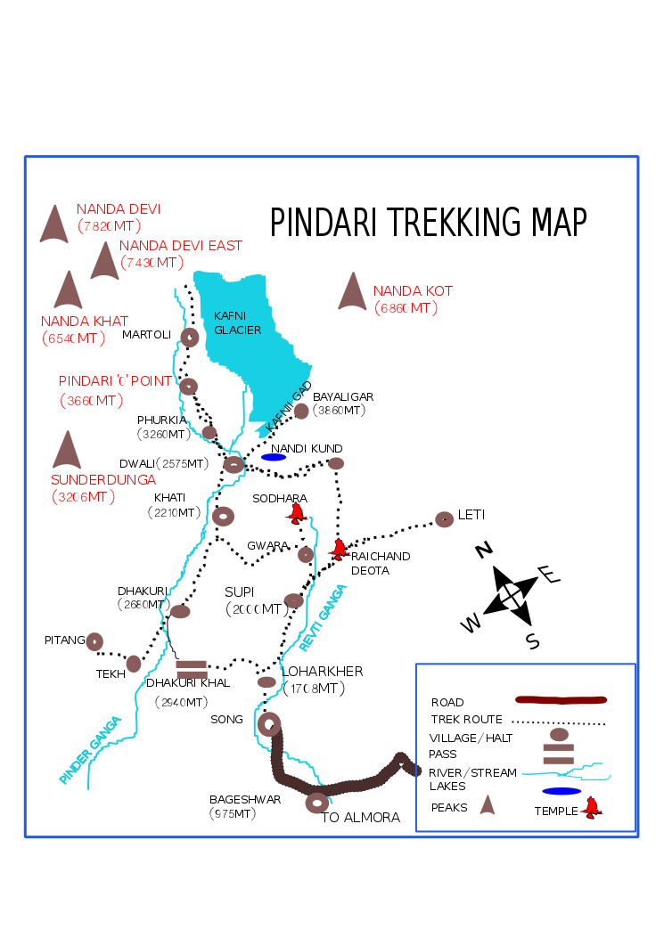
The Pindari Glacier is a glacier found in the upper reaches of the Kumaon Himalayas, to the southeast of Nanda Devi and Nanda Kot. Geography The glacier is about 9 kilometers long and gives rise to the Pindar River which meets the Alakananda at Karnaprayag in the Garhwal district. The trail to reach the glacier crosses the villages of Saung, Loharkhet, crosses over the Dhakuri Pass, continues onto Khati village (the last inhabited village on the trail), Dwali, Phurkia and finally Zero Point, Pindar, the end of the trail. Though most of the trail is along the banks of the Pindari River, the river is mostly hidden until after Khati. The Pindari Glacier trail provides for a round-trip trek that most people find comfortable to complete in 6 days. The Pindari Glacier is also famous for other adventure sports like Ice climbing and Mountain biking. Retreat Several surveys have mapped the retreat of Pindari over the years. The glacier was first surveyed by G.de P.Cotter in ... [...More Info...] [...Related Items...] OR: [Wikipedia] [Google] [Baidu] |
Kumaon Division
Kumaon (; , ; historically romanised as KemāonJames Prinsep (Editor)John McClelland ) is a List of divisions in India, revenue and administrative division in the Indian state of Uttarakhand. It spans over the eastern half of the state and is bounded on the north by Tibet, on the east by Nepal, on the south by the state of Uttar Pradesh, and on the west by Garhwal Division, Garhwal. Kumaon comprises six districts of the state: Almora district, Almora, Bageshwar district, Bageshwar, Champawat district, Champawat, Nainital district, Nainital, Pithoragarh district, Pithoragarh and Udham Singh Nagar district, Udham Singh Nagar. Historically known as Manaskhand and then Kurmanchal, the Kumaon region has been ruled by several dynasties over the course of history; most notably the Katyuri kings, Katyuris and the Chand kings, Chands. The Kumaon division was established in 1816, when the British reclaimed this region from the Gorkha Kingdom, Gorkhas, who had annexed the erstwhile Kumaon ... [...More Info...] [...Related Items...] OR: [Wikipedia] [Google] [Baidu] |
Ice Climbing
Ice climbing is a climbing discipline that involves ascending routes consisting entirely of frozen water. To ascend, the ice climber uses specialist equipment, particularly double ice axes (or the more modern ice tools) and rigid crampons. To protect the route, the ice climber uses steel ice screws that require skill to employ safely and rely on the ice holding firm in any fall. Ice climbing routes can vary significantly by type, and include seasonally frozen waterfalls, high permanently frozen alpine couloirs, and large hanging icicles. From the 1970s, ice climbing developed as a standalone skill from alpine climbing (where ice climbing skills are used on ice and snow). Ice climbing grades peak at WI6 to WI7 as ice tends to hang vertically at its most severe. WI7 is very rare and usually attributed to overhanging ice with serious risk issues (i.e. unstable ice, little protection, and a risk of death). Mixed climbing has pushed the technical difficulty of ice climbi ... [...More Info...] [...Related Items...] OR: [Wikipedia] [Google] [Baidu] |
Hiking Trails In Uttarakhand
A hike is a long, vigorous walk, usually on trails or footpaths in the countryside. Walking for pleasure developed in Europe during the eighteenth century. Long hikes as part of a religious pilgrimage have existed for a much longer time. "Hiking" is the preferred term in Canada and the United States; the term "walking" is used in these regions for shorter, particularly urban walks. In the United Kingdom and Ireland, the word "walking" describes all forms of walking, whether it is a walk in the park or backpacking in the Alps. The word hiking is also often used in the UK, along with rambling, hillwalking, and fell walking (a term mostly used for hillwalking in northern England). The term bushwalking is endemic to Australia, having been adopted by the Sydney Bush Walkers Club in 1927. In New Zealand a long, vigorous walk or hike is called tramping. It is a popular activity with numerous hiking organizations worldwide, and studies suggest that all forms of walking have health bene ... [...More Info...] [...Related Items...] OR: [Wikipedia] [Google] [Baidu] |
Kafni Glacier
The Kafni Glacier is located in the upper reaches of the Kumaon Himalayas, to the southeast of Nanda Devi. The glacier gives rise to the Kafni River, which is a tributary of the Pindar River. The Pindar River is a tributary to Alaknanda River, which eventually is one of the two headstreams of the Ganges. This is relatively small glacier but a popular trekking destination along with Pindari Glacier. List of peaks nearby A list of notable peaks adjacent to, near to or seen on the Kafni Glacier Trek includes: * Nanda Kot, * Changuch ( 6322m ) * Maiktoli ( 6803m ) * Mrigthuni ( 6855m ) * Nanda Devi ( 7816m ) * Nanda Khat ( 6611m ) * Panwali Dwar ( 6663m ) * Sunanda Devi ( 7434m ) * Tharkot ( 6099m ) * Nanda Bhanar ( 6236m ) * Nanda Khani ( 6029m ) * Bauljuri ( 5922m ) * Lapsa Dhura ( 6000m ) List of glaciers nearby A list of notable glaciers adjacent to or near the Kafni Glacier includes: * Pindari Glacier * Milam Glacier * Maiktoli Glacier Trek Route The glacier is located ... [...More Info...] [...Related Items...] OR: [Wikipedia] [Google] [Baidu] |
List Of Glaciers
A glacier ( ) or () is a persistent body of dense ice that is constantly moving under its own weight; it forms where the accumulation of snow exceeds its ablation (melting and sublimation) over many years, often centuries. Glaciers slowly deform and flow due to stresses induced by their weight, creating crevasses, seracs, and other distinguishing features. Because glacial mass is affected by long-term climate changes, e.g., precipitation, mean temperature, and cloud cover, glacial mass changes are considered among the most sensitive indicators of climate change. There are about 198,000 to 200,000 glaciers in the world. Catalogs of glaciers include:World Glacier Inventory* World Glacier Monitoring ServiceGlobal Land Ice Measurements from Space (GLIMS) Glacier Database Glaciers by continent
|
Ganges
The Ganges ( ; in India: Ganga, ; in Bangladesh: Padma, ). "The Ganges Basin, known in India as the Ganga and in Bangladesh as the Padma, is an international which goes through India, Bangladesh, Nepal and China." is a trans-boundary river of Asia which flows through India and Bangladesh. The river rises in the western Himalayas in the States and union territories of India, Indian state of Uttarakhand. It flows south and east through the Gangetic Plain, Gangetic plain of North India, receiving the right-bank tributary, the Yamuna, which also rises in the western Indian Himalayas, and several left-bank tributaries from Nepal that account for the bulk of its flow. In West Bengal state, India, a feeder canal taking off from its right bank diverts 50% of its flow southwards, artificially connecting it to the Hooghly River. The Ganges continues into Bangladesh, its name changing to the Padma River, Padma. It is then joined by the Jamuna River (Bangladesh), Jamuna, the lower str ... [...More Info...] [...Related Items...] OR: [Wikipedia] [Google] [Baidu] |
International Geophysical Year
The International Geophysical Year (IGY; ), also referred to as the third International Polar Year, was an international scientific project that lasted from 1 July 1957 to 31 December 1958. It marked the end of a long period during the Cold War when scientific interchange between East and West had been seriously interrupted. Sixty-seven countries participated in IGY projects, although one notable exception was the mainland China, People's Republic of China, which was protesting against the participation of the Republic of China (Taiwan). East and West agreed to nominate the Belgian Marcel Nicolet as secretary general of the associated international organization. The IGY encompassed fourteen Earth science disciplines: Auroral light, aurora, airglow, cosmic rays, Earth's magnetic field, geomagnetism, gravity, ionosphere, ionospheric physics, longitude and latitude determinations (precision mapping), meteorology, oceanography, Ionizing radiation, nuclear radiation, glaciology, seismo ... [...More Info...] [...Related Items...] OR: [Wikipedia] [Google] [Baidu] |
Glacial Motion
Glacial motion is the motion of glaciers, which can be likened to rivers of ice. It has played an important role in sculpting many landscapes. Most lakes in the world occupy basins scoured out by glaciers. Glacial motion can be fast (up to , observed on Jakobshavn Isbræ in Greenland) or slow ( on small glaciers or in the center of ice sheets), but is typically around . Processes of motion Glacier motion occurs from four processes, all driven by gravity: basal sliding, glacial quakes generating fractional movements of large sections of ice, bed deformation, and internal deformation. * In the case of basal sliding, the entire glacier slides over its bed. This type of motion is enhanced if the bed is soft sediment, if the glacier bed is thawed and if meltwater is prevalent. * Bed deformation is thus usually limited to areas of sliding. Seasonal melt ponding and penetrating under glaciers shows seasonal acceleration and deceleration of ice flows affecting whole icesheets. * ... [...More Info...] [...Related Items...] OR: [Wikipedia] [Google] [Baidu] |
PINDARI GLACIERMAPENGLISH Made By Sumita Roy
The Pindaris (Bhalse, Maratha, Rohilla and Pathans) were irregular military plunderers and foragers in 17th- through early 19th-century Indian subcontinent who accompanied initially the Mughal army, Mughal Army, and later the Maratha Army, and finally on their own before being eliminated in the 1817–19 Pindari War.Pindari: Indian History Encyclopædia Britannica They were unpaid and their compensation was entirely the booty they plundered during wars and raids. They were mostly horsemen armed with spears and swords who would create chaos and deliver intelligence about the enemy positions to benefit the army they accompanied. The majority of their leaders were Muslims, but also had people of all classes and religions. The earliest m ... [...More Info...] [...Related Items...] OR: [Wikipedia] [Google] [Baidu] |
Mountain Biking
Mountain biking (MTB) is a sport of riding bicycles off-road, often over rough terrain, usually using specially designed mountain bikes. Mountain bikes share similarities with other bikes but incorporate features designed to enhance durability and performance in rough terrain, such as air or coil-sprung shocks used as suspension, larger and wider wheels and tires, stronger frame materials, and mechanically or hydraulically actuated disc brakes. Mountain biking can generally be broken down into distinct categories: Cross-country cycling, cross country, trail riding#Mountain biking, trail, all mountain, Enduro (mountain biking), enduro, Downhill cycling, downhill and freeride (mountain biking), freeride. About The sport requires endurance, core and back strength, balance, bike handling skills, and self-reliance. Advanced riders pursue both steep technical descents and high-incline climbs. In the case of freeride, downhill, and dirt jumping, aerial maneuvers are performed off bo ... [...More Info...] [...Related Items...] OR: [Wikipedia] [Google] [Baidu] |
Himalayas
The Himalayas, or Himalaya ( ), is a mountain range in Asia, separating the plains of the Indian subcontinent from the Tibetan Plateau. The range has some of the Earth's highest peaks, including the highest, Mount Everest. More than list of highest mountains on Earth, 100 peaks exceeding elevations of above sea level lie in the Himalayas. The Himalayas abut on or cross territories of Himalayan states, six countries: Nepal, China, Pakistan, Bhutan, India and Afghanistan. The sovereignty of the range in the Kashmir region is disputed among India, Pakistan, and China. The Himalayan range is bordered on the northwest by the Karakoram and Hindu Kush ranges, on the north by the Tibetan Plateau, and on the south by the Indo-Gangetic Plain. Some of the world's major rivers, the Indus River, Indus, the Ganges river, Ganges, and the Yarlung Tsangpo River, Tsangpo–Brahmaputra River, Brahmaputra, rise in the vicinity of the Himalayas, and their combined drainage basin is home to some 6 ... [...More Info...] [...Related Items...] OR: [Wikipedia] [Google] [Baidu] |


