|
Pilling Sands
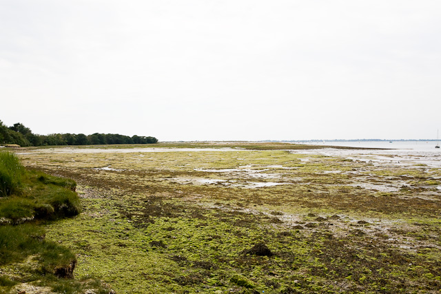
Pilling Sands is a tidal marsh in the Borough of Wyre, Lancashire, England. Named after the village of Pilling, located on the Fylde coast immediately to the south, it forms part of the southern edge of Morecambe Bay. Cockerham Sands adjoins it to the east. The -long Lancashire Coastal Way runs beside the sands. This section is closed from 26 December to Good Friday to protect lambs and birdlife. Rare birds for Lancashire that have been spotted near the sands include lesser yellowlegs and hoopoe Hoopoes () are colourful birds found across Africa, Asia, and Europe, notable for their distinctive "crown" of feathers. Three living and one extinct species are recognized, though for many years all of the extant species were lumped as a single .... In 2022, the North West Inshore Fisheries and Conservation Authority found that the Pilling Sands cockle fishery was, in a Habitats Regulations Assessment, in non-compliance of the North West Sea Fisheries Commission byelaw 13A, and wa ... [...More Info...] [...Related Items...] OR: [Wikipedia] [Google] [Baidu] |
Heysham Power Station
Heysham nuclear power station is operated by EDF Energy in Heysham, Lancashire, England. The site is divided into two separately-managed nuclear power stations, Heysham 1 and Heysham 2, both with two reactors of the advanced gas-cooled reactor (AGR) type. In 2010, the British government announced that Heysham was one of the eight sites it considered suitable for future nuclear power stations. On 1 August 2016, Heysham 2's Unit 8 broke the world record for longest continuous operation of a nuclear generator without a shutdown. This record-breaking run exceeds the previous record of 894days set by Pickering Nuclear Generating Station's Unit 7 (Lake Ontario, Canada) in 1994. The reactor has generated 13.5TWh of electricity so far during this continuous operation, taking its lifetime generation to 115.46TWh. Heysham 1 Construction of Heysham 1, which was undertaken by British Nuclear Design & Construction (BNDC), a consortium backed of English Electric, Babcock & Wilcox and Tayl ... [...More Info...] [...Related Items...] OR: [Wikipedia] [Google] [Baidu] |
Borough Of Wyre
Wyre is a local government district with borough status in Lancashire, England. The population of the non-metropolitan district at the 2011 census was 107,749. The district borders the unitary authority area of Blackpool as well as the districts of Lancaster, Ribble Valley, Fylde and Preston. The council is based in Poulton-le-Fylde. The district is named after the River Wyre, which runs through the district. The district is a rare contemporary example of a non-contiguous local government area. There are no road or rail connections between the parts of the borough divided by the River Wyre, and it is necessary to travel through the Fylde district in order to travel between the two divided parts of Wyre, or else use the passenger ferry between Fleetwood and Knott End. The borough also includes parts of Blackpool built-up area. History The district was created on 1 April 1974 under the Local Government Act 1972, as a non-metropolitan district covering the territory o ... [...More Info...] [...Related Items...] OR: [Wikipedia] [Google] [Baidu] |
Lancashire
Lancashire ( , ; abbreviated Lancs) is the name of a Historic counties of England, historic county, Ceremonial County, ceremonial county, and non-metropolitan county in North West England. The boundaries of these three areas differ significantly. The non-metropolitan county of Lancashire was created by the Local Government Act 1972. It is administered by Lancashire County Council, based in Preston, Lancashire, Preston, and twelve district councils. Although Lancaster, Lancashire, Lancaster is still considered the county town, Preston is the administrative centre of the non-metropolitan county. The ceremonial county has the same boundaries except that it also includes Blackpool and Blackburn with Darwen, which are unitary authorities. The historic county of Lancashire is larger and includes the cities of Manchester and Liverpool as well as the Furness and Cartmel peninsulas, but excludes Bowland area of the West Riding of Yorkshire transferred to the non-metropolitan county ... [...More Info...] [...Related Items...] OR: [Wikipedia] [Google] [Baidu] |
Pilling
Pilling is a village and civil parish within the Wyre borough of Lancashire, England. It is north-northeast of Poulton-le-Fylde, south-southwest of Lancaster and northwest of Preston, in a part of the Fylde known as Over Wyre. The civil parish of Pilling, which includes the localities of Stake Pool, Scronkey and Eagland Hill, had a total resident population of 1,739 in 2001, increasing to 2,020 at the 2011 Census. Populations in the 19th century ranged from 1,281 in 1851 to 1,572 in 1871. Etymology Eilert Ekwall suggests the name is Celtic, linking it with the Welsh place-name element "Pîl" (rendered as Pyl in Old English). This etymology would suggest the settlement started as a tidal inlet used as a harbour. Ekwall suggested the geography of Pilling may be "accurately described as a pill". The name appears as ''Pylin'' in 1246 and, if the name is indeed Celtic in origin, the termination is almost certainly the same as the common Welsh diminutive suffix "-yn", giv ... [...More Info...] [...Related Items...] OR: [Wikipedia] [Google] [Baidu] |
Tidal Marsh
A tidal marsh (also known as a type of "tidal wetland") is a marsh found along rivers, coasts and estuaries which floods and drains by the tidal movement of the adjacent estuary, sea or ocean. Tidal marshes are commonly zoned into lower marshes (also called intertidal marshes) and upper or high marshes, based on their elevation above sea level. A middle marsh zone also exists for tidal freshwater marshes. Tidal marshes may be further classified into back-barrier marshes, estuarine brackish marshes and tidal freshwater marshes, depending on the influence of sea level. Coastal Coastal tidal marshes are found within coastal watersheds and encompass a variety of types including fresh and salt marshes, bottomland hardwood swamps, mangrove swamps, and palustrine wetlands. Island and barrier island Tidal Marshes also form between a main shoreline and barrier islands. These elongated shifting landforms evolve parallel and in close proximity to the shoreline of a tidal marsh. Many ... [...More Info...] [...Related Items...] OR: [Wikipedia] [Google] [Baidu] |


