|
Pilkholi
Pilkholi is a village located in the Almora district of Uttarakhand state, India. It is located close to Ranikhet and Chaubatia Chaubattia is a settlement in Almora district, in the state of Uttarakhand, northern India. It is located roughly south of the cantonment town of Ranikhet. Chabattia is above sea level, within sight of the western peaks of the Himalayas. Its na .... The village had a population of 1,154 in 2011. References Villages in Almora district {{Uttarakhand-geo-stub ... [...More Info...] [...Related Items...] OR: [Wikipedia] [Google] [Baidu] |
Chaubatia
Chaubattia is a settlement in Almora district, in the state of Uttarakhand, northern India. It is located roughly south of the cantonment town of Ranikhet. Chabattia is above sea level, within sight of the western peaks of the Himalayas. Its name,in Kumaoni language, literally means a common meeting point of four paths ("chau" meaning ''four'' and "bat" meaning ''path''). It is named this way because of its location at the intersection of four places connects in front of Rawat Building: Bhargaon, Ranikhet, Dehrti and Pilkholi. Chaubattia is best known as the location of a botanical garden and fruit orchard which are popular with tourists to the region. The gardens contain predominantly apple, peach, plum and apricot An apricot (, ) is a fruit, or the tree that bears the fruit, of several species in the genus '' Prunus''. Usually, an apricot is from the species '' P. armeniaca'', but the fruits of the other species in ''Prunus'' sect. ''Armeniaca'' are al ... trees. It ... [...More Info...] [...Related Items...] OR: [Wikipedia] [Google] [Baidu] |
Almora District
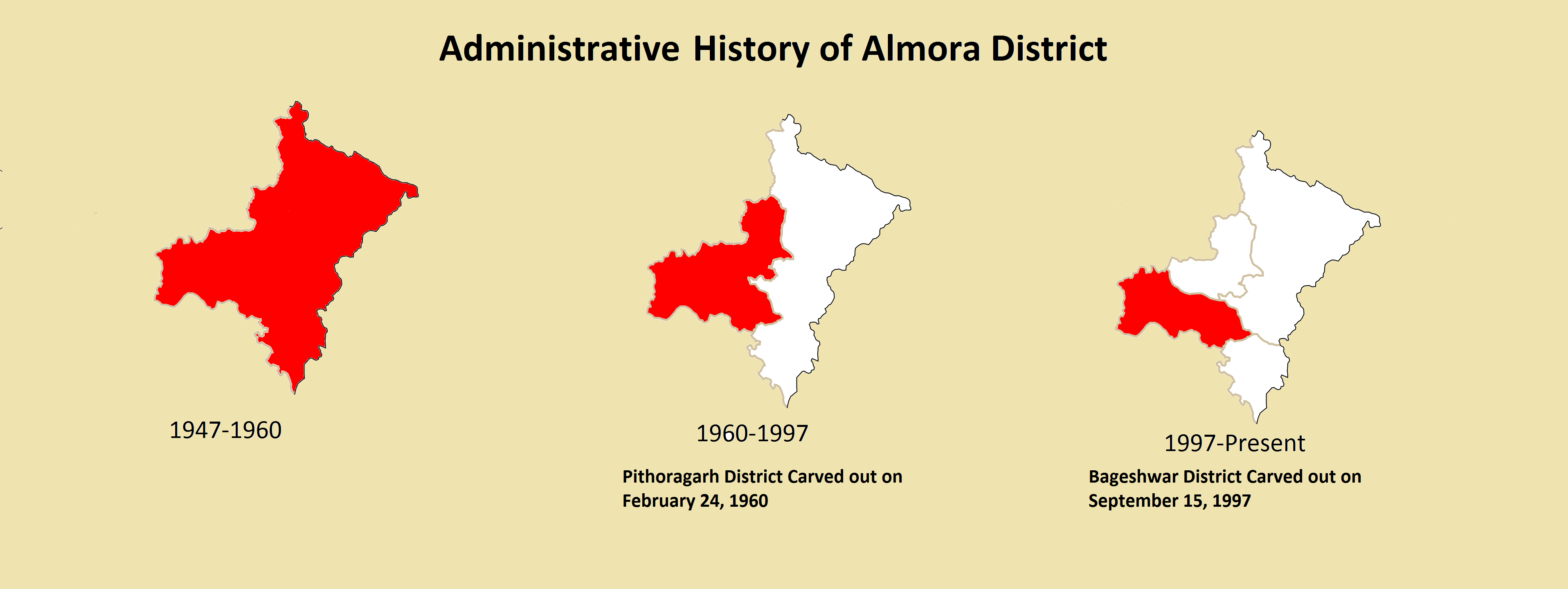
Almora is a district in the Kumaon Division of Uttarakhand state, India. The headquarters is at Almora. It is 1,638 meters above sea level. The neighbouring regions are Pithoragarh district to the east, Chamoli district to the west, Bageshwar district to the north and Nainital district to the south. History The ancient town of Almora was capital of the Kumaon Kingdom, before its establishment, it was under the possession of Katyuri king Baichaldeo. Later on when the Chand dynasty was founded in Champawat, the town of Almora was founded at this centrally located place in 1568 by Kalyan Chand. Later Chand kings shifted the capital of the Kumaon Kingdom from Champawat to Almora. Almora town was the administrative headquarter of the Kumaun district; that was formed in 1815 following the defeat of Gorkha army in the Anglo-Gorkha war and the 1816 Treaty of Sugauli. The Kumaun district then consisted of the complete Kumaon Division excluding the Terai district with its hea ... [...More Info...] [...Related Items...] OR: [Wikipedia] [Google] [Baidu] |
Uttarakhand
Uttarakhand ( , or ; , ), also known as Uttaranchal ( ; List of renamed places in India, the official name until 2007), is a States and union territories of India, state in the North India, northern part of India. It is often referred to as the "Devbhumi" (literally 'Land of the Gods') due to its religious significance and numerous Hindu temples and Hindu pilgrimage sites in India, pilgrimage centres found throughout the state. Uttarakhand is known for the natural environment of the Himalayas, the Bhabar and the Terai regions. It borders the Tibet Autonomous Region of China to the north; the Sudurpashchim Province of Nepal to the east; the Indian states of Uttar Pradesh to the south and Himachal Pradesh to the west and north-west. The state is divided into two divisions, Garhwal division, Garhwal and Kumaon division, Kumaon, with a total of List of districts of Uttarakhand, 13 districts. The winter capital of Uttarakhand is Dehradun, the largest city of the state, which is a ra ... [...More Info...] [...Related Items...] OR: [Wikipedia] [Google] [Baidu] |
Ranikhet
Ranikhet ( Kumaoni: ) is a hill station and cantonment town, nearby Almora Town in Almora district in the Indian state of Uttarakhand. It is the home for the Military Hospital, Kumaon Regiment (KRC) and Naga Regiment and is maintained by the Indian Army. Ranikhet is at an altitude of 1,869 metres (6,132 ft) above sea level and within sight of the western peaks of the Himalayas. Ranikhet is a Class IV town with a civic status of a Cantonment board. History Ranikhet, which means ''Queen's Meadow'' in Kumaoni, gets its name from a local legend, which states that it was here, that Raja Sudhardev, a Katyuri ruler, won the heart of his queen, Rani Padmini, who subsequently chose the area for her residence, giving it the name, Ranikhet, though no palace exists in the area. Ranikhet had been under Nepalese rule after the Nepalese invasion of Kumaon and Doti in 1790, and the Kumaonis won it under the leadership of their able General Kashi Nath Adhikari – after whom the small t ... [...More Info...] [...Related Items...] OR: [Wikipedia] [Google] [Baidu] |


