|
Picunche
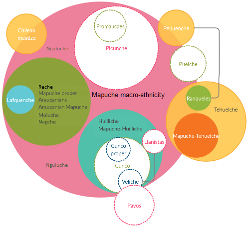
The Picunche (a Mapudungun word meaning "North People"), also referred to as ''picones'' by the Spanish, were a Mapudungun-speaking people living to the north of the Mapuches or Araucanians (a name given to those Mapuche living between the Itata and Toltén rivers) and south of the Choapa River and the Diaguitas. Until the Conquest of Chile the Itata was the natural limit between the Mapuche, located to the south, and Picunche, to the north. During the Inca attempt to conquer Chile the southern Picunche peoples that successfully resisted them were later known as the Promaucaes. The Picunche living north of the Promaucaes were called ''Quillotanes'' (those living in the Aconcagua River valley north to the Choapa) and '' Mapochoes'' (those living in the Maipo River basin) by the Spanish, and were part of the Inca Empire at the time when the first Spaniards arrived in Chile. Among the peoples the Spanish called the Promaucaes, the people of the Rapel River valley were part ... [...More Info...] [...Related Items...] OR: [Wikipedia] [Google] [Baidu] |
Mapuche
The Mapuche ( , ) also known as Araucanians are a group of Indigenous peoples of the Americas, Indigenous inhabitants of south-central Chile and southwestern Argentina, including parts of Patagonia. The collective term refers to a wide-ranging ethnicity composed of various groups who share a common social, religious, and economic structure, as well as a common linguistic heritage as Mapudungun speakers. Their homelands once extended from Choapa River, Choapa Valley to the Chiloé Archipelago and later spread eastward to Puelmapu, a land comprising part of the Pampas, Argentine pampa and Patagonia. Today the collective group makes up over 80% of the Indigenous peoples in Chile and about 9% of the total Chilean population. The Mapuche are concentrated in the Araucanía (historic region), Araucanía region. Many have migrated from rural areas to the cities of Santiago and Buenos Aires for economic opportunities, more than 92% of the Mapuches are from Chile. The Mapuche traditional e ... [...More Info...] [...Related Items...] OR: [Wikipedia] [Google] [Baidu] |
Promaucaes
Promaucae, also spelled as ''Promaucas'' or ''Purumaucas'' (from Quechua ''purum awqa'': wild enemy), were an Indigenous pre-Columbian Mapuche tribal group that lived in the present territory of Chile, south of the Maipo River basin of Santiago, Chile and the Itata River. Those to the north were called ''Quillotanes'' and '' Mapochoes'' by the Spanish colonists). They spoke Mapudungun, like the Moluche to the south, and were part of the Picunche tribe that lived north of the Itata River. Description The Inca referred to all the peoples who were not under their empire as ''puruma auca''. Because these Picunche tribes were successful in defending their territory against the Inca Empire in the Battle of the Maule, they were given this distinctive name. In an effort to transliterate the word into Spanish phonetics, the Spanish referred to them as the ''Purumaucas'' or ''Promaucaes''. The early Spanish in the area knew their region as the province of Promaucae and its inhabitants ... [...More Info...] [...Related Items...] OR: [Wikipedia] [Google] [Baidu] |
Incas In Central Chile
Inca rule in Chile was brief, lasting from the 1470s to the 1530s when the Inca Empire was absorbed by Spain. The main settlements of the Inca Empire in Chile lay along the Aconcagua, Mapocho and Maipo rivers. Quillota in Aconcagua Valley was likely the Incas' foremost settlement. The bulk of the people conquered by the Incas in Central Chile were Diaguitas and part of the Promaucae (also called Picunches). Incas appear to have distinguished between a "province of Chile" and a "province of Copayapo" neighboring it to the north. In Aconcagua Valley the Incas settled people from the areas of Arequipa and possibly also the Lake Titicaca. Inca expansion The exact date of the conquest of Central Chile by the Inca Empire is not known. A study of ceramics from 2014 suggest Inca influence in Central Chile begun as early as 1390. Nevertheless, it is generally accepted that Central Chile was conquered during the reign of Topa Inca Yupanqui and most early Spanish chronicles point out t ... [...More Info...] [...Related Items...] OR: [Wikipedia] [Google] [Baidu] |
Itata River
The Itata River flows in the Ñuble Region, southern Chile. Until the Conquest of Chile, the Itata was the natural limit between the Mapuche The Mapuche ( , ) also known as Araucanians are a group of Indigenous peoples of the Americas, Indigenous inhabitants of south-central Chile and southwestern Argentina, including parts of Patagonia. The collective term refers to a wide-ranging e ..., located to the south, and Picunche, to the north. The Itata River flows westward and reaches the Pacific Ocean approximately 60 kilometers north of Conception. See also * Itata * List of rivers in Chile References * (December 2004)Cuenca de rio Itata() External links Google Map of Itata River Rivers of Chile Rivers of Ñuble Region {{Chile-river-stub ... [...More Info...] [...Related Items...] OR: [Wikipedia] [Google] [Baidu] |
Quillota
Quillota is a city located in the valley of the Aconcagua River in Valparaíso Region, Chile. It is the capital and largest city of Quillota Province. It is surrounded by the localities of San Isidro, La Palma, Pocochay, and San Pedro. It is an important agricultural center, mainly because of the plantations of avocado and cherimoya trees. Quillota is connected to the city of La Calera by the small city of La Cruz. Charles Darwin described the area's agriculture and the landscape in his book '' The Voyage of the Beagle''. In nearby La Campana National Park, there is a plaque at a viewpoint commemorating Darwin's visit. History The Quillota Valley had been populated for about 2,000 years. At the outset, the area was inhabited by Native Americans of the Bato and Lleo-Lleo cultures, who had migrated to the valley because of the fertile land south of the Aconcagua River. These natives were later influenced by Mapuches and Diaguitas. he Diaguitas are credited with the e ... [...More Info...] [...Related Items...] OR: [Wikipedia] [Google] [Baidu] |
Inca Empire
The Inca Empire, officially known as the Realm of the Four Parts (, ), was the largest empire in pre-Columbian America. The administrative, political, and military center of the empire was in the city of Cusco. The History of the Incas, Inca civilisation rose from the Peruvian highlands sometime in the early 13th century. The Portuguese explorer Aleixo Garcia was the first European to reach the Inca Empire in 1524. Later, in 1532, the Spanish Empire, Spanish began the conquest of the Inca Empire, and by 1572 Neo-Inca State, the last Inca state was fully conquered. From 1438 to 1533, the Incas incorporated a large portion of western South America, centered on the Andes, Andean Mountains, using conquest and peaceful assimilation, among other methods. At its largest, the empire joined modern-day Peru with what are now western Ecuador, western and south-central Bolivia, northwest Argentina, the southwesternmost tip of Colombia and Incas in Central Chile, a large portion of modern- ... [...More Info...] [...Related Items...] OR: [Wikipedia] [Google] [Baidu] |
Maipo River
The Maipo River is the main river flowing through the Santiago Metropolitan Region and the Valparaíso Region of Chile. It is located just south of the capital of Santiago. The Mapocho River, which flows through central Santiago, is one of its tributaries. Its headwaters are on the west slope of Maipo volcano, in the Andes. The Maipo River is by far the major source of irrigation and potable water for the region. The river's mouth bar have moved to disconnect the river from the sea several times in history, for example, after the 2010 Chile earthquake and then again since January 19, 2023. This last change in bar morphology was a consequence of a storm surge. By January 28 a ditch had been made to reconnect the river to the sea. Governor of Valpraíso Region Rodrigo Mundaca criticized however the fact that works were carried out without permission. Low discharge rates caused by excessive uptakes of water in Maipo River have been credited for the inability of the river to bre ... [...More Info...] [...Related Items...] OR: [Wikipedia] [Google] [Baidu] |
Spaniards
Spaniards, or Spanish people, are a Romance-speaking ethnic group native to the Iberian Peninsula, primarily associated with the modern nation-state of Spain. Genetically and ethnolinguistically, Spaniards belong to the broader Southern and Western European populations, exhibiting a high degree of continuity with other Indo-European-derived ethnic groups in the region. Spain is also home to a diverse array of national and regional identities, shaped by its complex history. These include various languages and dialects, many of which are direct descendants of Latin, the language imposed during Roman rule. Among them, Spanish (also known as Castilian) is the most widely spoken and the only official language across the entire country. Commonly spoken regional languages include, most notably, the sole surviving indigenous language of Iberia, Basque, as well as other Latin-descended Romance languages like Spanish itself, Catalan and Galician. Many populations outside Sp ... [...More Info...] [...Related Items...] OR: [Wikipedia] [Google] [Baidu] |
Theodor Ohlsen
Theodor Ohlsen (1855 in Klein-Brebel – 1913 in Wiesbaden) was a German landscape, marine and portrait painter. Life Ohlsen, son of a tailor, studied in Hamburg, Munich and Berlin, where he was a student of Gyula Benczúr, Ludwig von Löfftz, Karl Gussow and Franz von Defregger. On 20 October 1880, he entered the Academy of Fine Arts, Munich. He was a member of the Hamburg Artists' Association. From 1883 to 1893 he travelled to several continents, with Chile being a particular fascination for him. He captured the country, its people and its way of life in many travel pictures, some of which are also of cultural and historical significance. After his return to Hamburg in 1895 he exhibited two large-format marine paintings at the Hamburg Great Art Exhibition and at the Saxon Art Association. auf arcadja.com [...More Info...] [...Related Items...] OR: [Wikipedia] [Google] [Baidu] |
Mataquito River
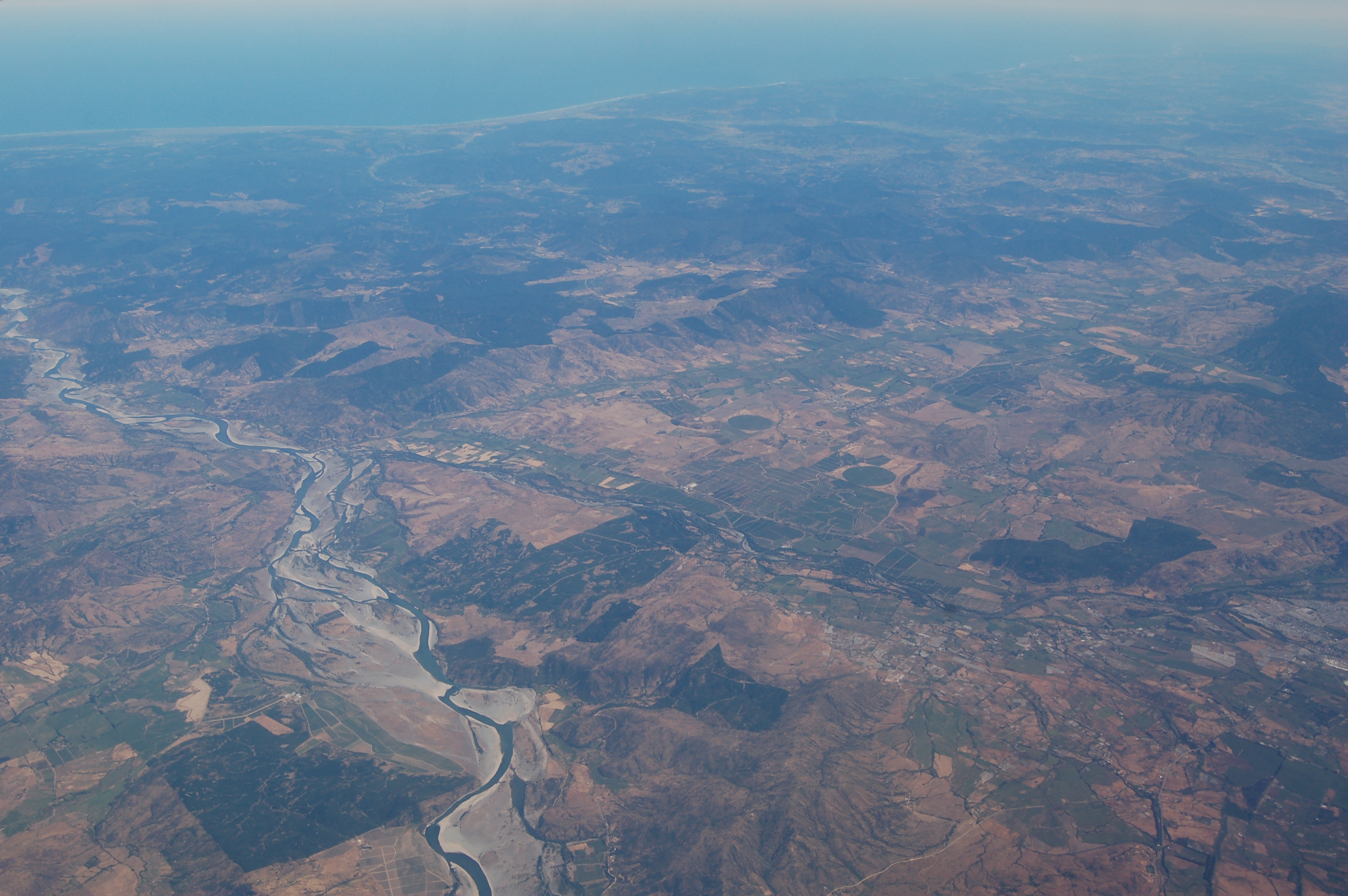
Mataquito is a river located in the Province of Curicó, Maule Region of Chile and formed by the union of rivers Teno and Lontué about 10 kilometers west of Curicó near the locality of Sagrada Familia and empties into the Pacific Ocean The Pacific Ocean is the largest and deepest of Earth's five Borders of the oceans, oceanic divisions. It extends from the Arctic Ocean in the north to the Southern Ocean, or, depending on the definition, to Antarctica in the south, and is ... south of the town of Iloca, Licantén. Sources Cuenca del río Mataquito Rivers of Maule Region Rivers of Chile {{Chile-river-stub ... [...More Info...] [...Related Items...] OR: [Wikipedia] [Google] [Baidu] |
Maule River
The Maule river or Río Maule ( Mapudungun: ''rainy'') is one of the most important rivers of Chile. It is inextricably linked to the country's pre-Hispanic (Inca) times, the country's conquest, colonial period, wars of Independence, modern history, agriculture (wine, traditional crops), culture (literature, poetry, folklore), religion, economy and politics. The Maule River marked the southern limits of the Inca Empire. Many famous men and women in Chile's history have been born in the Region named after the river. The river has also lent its name to one of the viticultural regions of the country (also known as appellations), the Valley of Maule, a subregion of the Central Valley. Upper reach The river is 240 km long and its basin covers around 20,600 km2. Thirty percent of the basin is located in the Andean range. It is born in Laguna del Maule in Talca Province, at an altitude of 2,200 mt in the vicinity of the border with Argentina. From that point the rivers ... [...More Info...] [...Related Items...] OR: [Wikipedia] [Google] [Baidu] |


