|
Perth And Dunkeld Railway
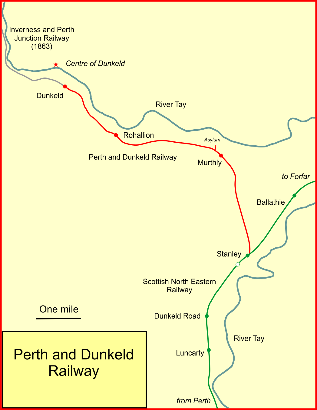
The Perth and Dunkeld Railway was a Scottish railway company. It was built from a junction with the Scottish Midland Junction Railway at Stanley, north of Perth, to a terminus at Birnam, on the south bank of the River Tay opposite Dunkeld. It was promoted by local landed proprietors, and opened in 1856. As a minor branch line inconveniently serving a modest town, its financial performance was poor. However, when a railway line from Inverness to Perth was promoted, the Dunkeld line was taken as part of the new route, which opened in 1863; the Perth and Dunkeld Railway Company ceased to exist, and the line was now part of the Inverness and Perth Junction Railway. The original line of the P&DR continues in use today, an intrinsic part of the Highland Main Line. Independence at first Aberdeen was connected to the railway network of Central Scotland in 1850. Inverness too expected a southward connection, but the intervening terrain was unpromising, and two railway schemes proposed ... [...More Info...] [...Related Items...] OR: [Wikipedia] [Google] [Baidu] |
Scotland
Scotland is a Countries of the United Kingdom, country that is part of the United Kingdom. It contains nearly one-third of the United Kingdom's land area, consisting of the northern part of the island of Great Britain and more than 790 adjacent Islands of Scotland, islands, principally in the archipelagos of the Hebrides and the Northern Isles. To the south-east, Scotland has its Anglo-Scottish border, only land border, which is long and shared with England; the country is surrounded by the Atlantic Ocean to the north and west, the North Sea to the north-east and east, and the Irish Sea to the south. The population in 2022 was 5,439,842. Edinburgh is the capital and Glasgow is the most populous of the cities of Scotland. The Kingdom of Scotland emerged as an independent sovereign state in the 9th century. In 1603, James VI succeeded to the thrones of Kingdom of England, England and Kingdom of Ireland, Ireland, forming a personal union of the Union of the Crowns, three kingdo ... [...More Info...] [...Related Items...] OR: [Wikipedia] [Google] [Baidu] |
George Murray, 6th Duke Of Atholl
George Augustus Frederick John Murray, 6th Duke of Atholl, (20 September 1814 – 16 January 1864) was a Scottish peer, important landowner, and freemason. Life Born at Great Cumberland Place, Westminster, Murray was the son of James Murray, 1st Baron Glenlyon. His father was the second son of John Murray, 4th Duke of Atholl, and his wife Lady Emily Frances Percy, a daughter of Hugh Percy, 2nd Duke of Northumberland. In 1837, he succeeded his father as Lord Glenlyon, gaining a seat in the House of Lords, and also served in the British Army as a lieutenant of the 2nd Dragoon Guards, retiring in 1840. As Lord Glenlyon, he re-formed the Atholl Highlanders in 1839 as his personal bodyguard. On 30 August of that year he attended the Archibald Montgomerie, 13th Earl of Eglinton, 13th Earl of Eglinton's tournament in Ayrshire in the guise of 'The Knight of the Gael', accompanied by a retinue of his Highlanders. In 1844, when Queen Victoria stayed at Blair Castle, the Atholl Highlanders ... [...More Info...] [...Related Items...] OR: [Wikipedia] [Google] [Baidu] |
26 & 27 Vict
6 (six) is the natural number following 5 and preceding 7. It is a composite number and the smallest perfect number. In mathematics A six-sided polygon is a hexagon, one of the three regular polygons capable of tessellation, tiling the plane. A hexagon also has 6 Edge (geometry), edges as well as 6 internal and external angles. 6 is the second smallest composite number. It is also the first number that is the sum of its proper divisors, making it the smallest perfect number. It is also the only perfect number that doesn't have a digital root of 1. 6 is the first unitary perfect number, since it is the sum of its positive proper unitary divisors, without including itself. Only five such numbers are known to exist. 6 is the largest of the four Harshad number, all-Harshad numbers. 6 is the 2nd superior highly composite number, the 2nd colossally abundant number, the 3rd triangular number, the 4th highly composite number, a pronic number, a congruent number, a harmonic divisor nu ... [...More Info...] [...Related Items...] OR: [Wikipedia] [Google] [Baidu] |
Dalguise
Dalguise (Scottish Gaelic Dàil Ghiuthais) is a settlement in Perth and Kinross, Scotland. It is situated on the western side of the River Tay on the B898 road, north of Dunkeld. Located there is Dalguise House, a place where, from the age of four, Beatrix Potter stayed annually with her family throughout the summer, from May till the end of the salmon season. History Dalguise House Plans to build a house in Dalguise were completed in 1714, and building was completed in 1753. Extensions to the property were built in 1791, 1812 and 1821. Beatrix Potter stayed at Dalguise House with her family during the early 1890s. Whilst staying at Dalguise in 1893, Potter wrote picture letters which provided the basis for her first book, ''The Tale of Peter Rabbit'', and the book ''The Tale of Jeremy Fisher''. The latter was influenced by her exploration of the River Tay. ''The Tale of Mrs Tiggy Winkle'', published in 1905, was also inspired by the Potters' old washer woman at Dalguise, Kitt ... [...More Info...] [...Related Items...] OR: [Wikipedia] [Google] [Baidu] |
Pass Of Killiecrankie
The Pass of Killiecrankie is a gorge at the lower end of River Garry, Perthshire, Glen Garry in Atholl, Scotland. It leads from Glen Garry into River Tummel, Strath Tummel. The A9 road (Scotland), A9 Road, the Highland Main Line, and a former military roads of Scotland, military road all run through the pass. The village of Killiecrankie lies at its northern end. Killiecrankie is part of the Loch Tummel national scenic area (Scotland), National Scenic Area, one of 40 such areas in Scotland, which are defined so as to identify areas of exceptional scenery and to ensure its protection by restricting certain forms of development. Footnotes External links Mountain passes of Scotland {{PerthKinross-geo-stub ... [...More Info...] [...Related Items...] OR: [Wikipedia] [Google] [Baidu] |
Blair Atholl
Blair Atholl (from the Scottish Gaelic: ''Blàr Athall'', originally ''Blàr Ath Fhodla'') is a village in Perthshire, Scotland, built about the confluence of the Rivers Tilt and Garry in one of the few areas of flat land in the midst of the Grampian Mountains. The Gaelic place-name Blair, from ''blàr'', 'field, plain', refers to this location. Atholl, which means 'new Ireland', from the archaic ''Ath Fhodla'' is the name of the surrounding district. On 13 March 2008, it was announced that Blair Atholl (together with some other Highland Perthshire villages) would be included in the Cairngorms National Park. This change was made at the request of the people of the town. The Forest of Atholl already formed part of the Cairngorms. Blair Castle Blair Atholl's most famous feature is Blair Castle (NN 865 662), one of Scotland's premier stately homes, and the last castle in the British Isles to be besieged, in 1746 during the last Jacobite rising. The Castle was the traditional ... [...More Info...] [...Related Items...] OR: [Wikipedia] [Google] [Baidu] |
Pass Of Drumochter
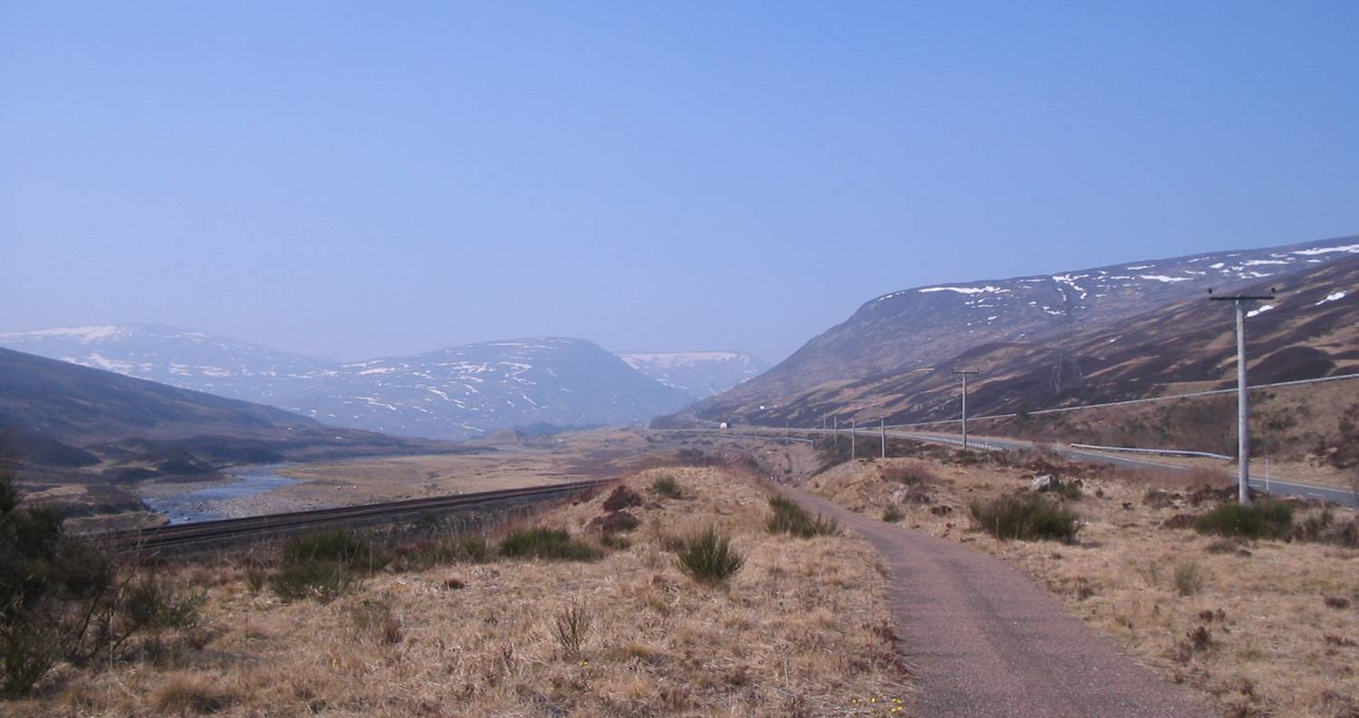
The Pass of Drumochter () meaning simply 'high ridge' is the main mountain pass between the northern and southern central Scottish Highlands. The A9 road (Great Britain), A9 road passes through here, as does the Highland Main Line, the railway between Inverness and the south of Scotland. The Sustrans NCR 7, National Cycle Route 7 between Glasgow and Inverness also runs through the pass. The pass is the only gap in the main Grampian Mountains, Grampian Watershed suitable for road traffic routes for almost 100 km, between Glen Coe (west) and Cairnwell Pass (east); the West Highland Railway is the only other crossing, at Corrour. The pass is a natural low point, where the headwaters of the river Spey, Spey and river Tay, Tay penetrate most deeply into the broad Gaick Plateau, with the River Garry, Perthshire, River Garry flowing south, and the River Truim north. The gap has been shaped into a "U" convenient for a transport corridor by glacial action over successive ice ages, al ... [...More Info...] [...Related Items...] OR: [Wikipedia] [Google] [Baidu] |
Grampian Mountains
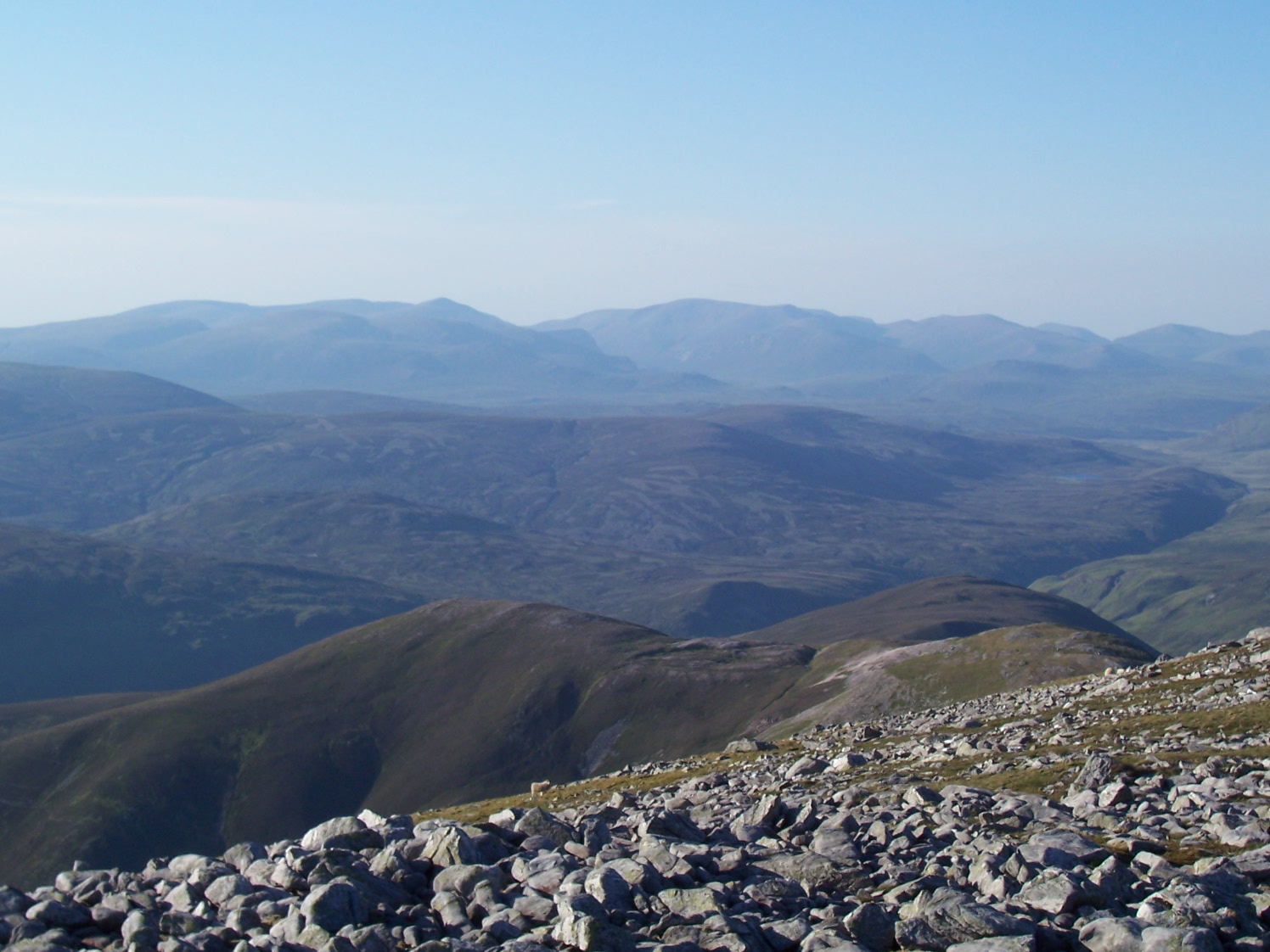
The Grampian Mountains () is one of the three major mountain ranges in Scotland, that together occupy about half of Scotland. The other two ranges are the Northwest Highlands and the Southern Uplands. The Grampian range extends northeast to southwest between the Highland Boundary Fault and the Great Glen. The range includes many of the highest mountains in the British Isles, including Ben Nevis (whose peak contains the highest point in the British Isles at above sea level) and Ben Macdhui (Scotland), Ben Macdui (whose peak contains second-highest at ). A number of rivers and streams rise in the Grampians, including the River Tay, Tay, River Spey, Spey, Cowie Water, Burn of Muchalls, Burn of Pheppie, Burn of Elsick, Cairnie Burn, River Don, Aberdeenshire, Don, River Dee, Aberdeenshire, Dee and River South Esk, Esk. The area is generally sparsely populated. There is some ambiguity about the extent of the range, and until the nineteenth century, they were generally considered to ... [...More Info...] [...Related Items...] OR: [Wikipedia] [Google] [Baidu] |
Kingussie
Kingussie ( ; ) is a small town in the Badenoch and Strathspey ward of the Highland council area of Scotland. Counties of Scotland, Historically in Inverness-shire, it lies beside the A9 road (Great Britain), A9 road, although the old route of the A9 serves as the town's main street which has been bypassed since 1979. Kingussie is south of Inverness, south of Aviemore, and north of Newtonmore. History The name "Kingussie" comes from the Scottish Gaelic, Gaelic, "Ceann a' Ghiuthsaich" which means "Head of the Pine forest". The ruins of the early 18th-century Ruthven Barracks (Historic Environment Scotland; open to visitors at all times) lie near the original site of the village, which was moved to avoid the flood plain of the River Spey. The Hanoverian Barracks were built on the site of Ruthven Castle, the seat of the John I Comyn, Lord of Badenoch, Comyns, Lord of Badenoch, Lords of Badenoch in the Middle Ages. On 9 January 2025 British big cats#Proven captures and rema ... [...More Info...] [...Related Items...] OR: [Wikipedia] [Google] [Baidu] |
River Spey
The River Spey () is a river in the northeast of Scotland. At it is the ninth longest river in the United Kingdom and the third longest and fastest-flowing river in Scotland. It is an important location for the traditions of salmon fishing and whisky production in Scotland. Etymology The origin of the name ''Spey'' is uncertain. A possible etymological genesis for the name ''Spey'' is Early Celtic ''*skwej-'', meaning "thorn". The involvement of a Pictish form of Welsh ''ysbyddad'', meaning "hawthorn", has been suggested, but adjudged unlikely. One proposal is a derivation from a Pictish cognate of Old Gaelic ''sceïd'', "vomit" (cf. Welsh ''chwydu''), which is dubious both on phonological and semantic grounds. Ptolemy named the river on his map of 150 as ''Tuesis''. The name 'Spey' first appears in 1451. Course The Spey is long. It rises at over at Loch Spey in Corrieyairack Forest in the Scottish Highlands, south of Fort Augustus. Some miles downstream from i ... [...More Info...] [...Related Items...] OR: [Wikipedia] [Google] [Baidu] |
Grantown-on-Spey
Grantown-on-Spey () is a town in the Highland Council Area, Counties of Scotland, historically within the county of Moray. It is located on a low plateau at Freuchie beside the river Spey at the northern edge of the Cairngorms, Cairngorm mountains, about south-east of Inverness ( by road). The town was founded in 1765 as a New town, planned settlement, and was originally called simply Grantown after Sir James Grant, 8th Baronet, Sir James Grant. The addition 'on Spey' was added by the burgh council in 1898. The town has several listed 18th and 19th century buildings, including several large hotels, and serves as a regional centre for tourism and services in the Strathspey, Scotland, Strathspey region. The town is Twinned cities, twinned with Notre-Dame-de-Monts in the Vendée, Pays de la Loire, France. History The burgh was founded in 1765 during the early stages of the Industrial Revolution, to encourage both agricultural marketing and handicrafts, as well as to increase ... [...More Info...] [...Related Items...] OR: [Wikipedia] [Google] [Baidu] |
Forres
Forres (; ) is a town and former royal burgh in the north of Scotland on the County of Moray, Moray coast, approximately northeast of Inverness and west of Elgin, Moray, Elgin. Forres has been a winner of the Scotland in Bloom award on several occasions. There are many geographical and historical attractions nearby such as the River Findhorn, and there are also classical, historical artifacts and monuments within the town itself, such as Forres Tolbooth and Nelson's Tower. Brodie Castle, the home of the Brodie Clan, lies to the west of the town, close to the A96. Pre-history and archaeology Between 2002 and 2013 some 70 hectares of land was investigated by archaeologists in advance of a proposed residential development on the southern fringes of the town. They found an extensive Iron Age settlement and evidence that people lived in the area from the Neolithic British Isles, Neolithic (Radiocarbon dating, radiocarbon dates from the 4th to the mid-3rd millennium BC were found) ... [...More Info...] [...Related Items...] OR: [Wikipedia] [Google] [Baidu] |
