|
Peral-Kannur
Kannur is a village located in the Puthige panchayath, in Kasaragod district of the Indian state of Kerala. Kannur is home to the Ananthapura Lake Temple (), a Hindu temple located in the middle of a lake. Peral-Kannur and Kannur Peral-Kannur is a small village under the administration of Puthige panchayath in Kasaragod district. Kannur is a city and headquarters of the Kannur district some 106 kilometers south. Demographics As of 2011 Census, Kannur village had total population of 2,421 where 1,183 are males and 1,238 are females. Kannur village spreads over with 445 families residing in it. Population in the age group 0-6 was 284 among which 147 are males and 137 are females. Kannur had overall literacy of 90% where male literacy stands at 94.1% and female literacy was 86.1%. Landmarks Peral-Kannur can be accessed from Madhur-Seethangoli road. The village school is located in this junction. The village Dargah and the watersfall can be accessed from this junction. Geogra ... [...More Info...] [...Related Items...] OR: [Wikipedia] [Google] [Baidu] |
Manjeshwaram Taluk
Manjeshwaram taluk is the northern most taluk of Kerala which borders Karnataka state. It is located in Kasaragod district, Kerala which was carved out from Kasaragod taluk on 2013. Constituent Villages Manjeshwaram taluk has 48 revenue villages. * Manjeshwaram Panchayat: Kunjathur, Hosabettu, Udyavar(Manjeshwaram CT), Hosangadi, Badaje * Meenja Panchayat: Meenja, Kadambar, Koliyoor, Kaliyoor, Talakala, Kuloor, Majibail, Moodambail * Vorkady Panchayat: Vorkady, Pavoor, Kodalamogaru, Pathur * Paivalike Panchayat: Paivalike, Chippar, Bayar, Kayyar, Kudalmarkala * Enmakaje Panchayat: Enmakaje, Sheni, Padre, Kattukukke * Puthige Panchayat: Edanad, Badoor, Kannur, Puthige, Angadimogaru, Mugu * Kumbla Panchayat: Kumbla, Ichilampady, Mogral, Bombrana, Arikady, Kidoor, Ujarulvar, * Mangalpady Panchayat: Uppala, Mannamkuzhi, Ichilangod, Mangalpady Mangalpady is a Grama Panchayat in Kasaragod district, Kerala. Uppala is the major town in this panchaya ... [...More Info...] [...Related Items...] OR: [Wikipedia] [Google] [Baidu] |
States And Union Territories Of India
India is a federalism, federal union comprising 28 federated state, states and 8 union territory, union territories, with a total of 36 entities. The states and union territories are further subdivided into List of districts in India, districts and smaller administrative divisions of India, administrative divisions. History Pre-independence The Indian subcontinent has been ruled by many different South Asian ethnic groups, ethnic groups throughout its history, each instituting their own policies of administrative division in the region. The British Raj mostly retained the administrative structure of the preceding Mughal Empire. India was divided into provinces (also called Presidencies), directly governed by the British, and princely states, which were nominally controlled by a local prince or raja loyal to the British Empire, which held ''de facto'' sovereignty (suzerainty) over the princely states. 1947–1950 Between 1947 and 1950 the territories of the prin ... [...More Info...] [...Related Items...] OR: [Wikipedia] [Google] [Baidu] |
Temple
A temple (from the Latin ) is a building reserved for spiritual rituals and activities such as prayer and sacrifice. Religions which erect temples include Christianity (whose temples are typically called church (building), churches), Hinduism (whose temples are called Mandir), Buddhism, Sikhism (whose temples are called Gurdwara, gurudwara), Jainism (whose temples are sometimes called derasar), Islam (whose temples are called mosques), Judaism (whose temples are called synagogues), Zoroastrianism (whose temples are sometimes called Agiary), the Baha'i Faith (which are often simply referred to as Baha'i House of Worship), Taoism (which are sometimes called Daoguan), Shinto (which are sometimes called Shinto shrine, Jinja), Confucianism (which are sometimes called the Temple of Confucius), and ancient religions such as the Ancient Egyptian religion and the Ancient Greek religion. The form and function of temples are thus very variable, though they are often considered by belie ... [...More Info...] [...Related Items...] OR: [Wikipedia] [Google] [Baidu] |
Backwater (river)
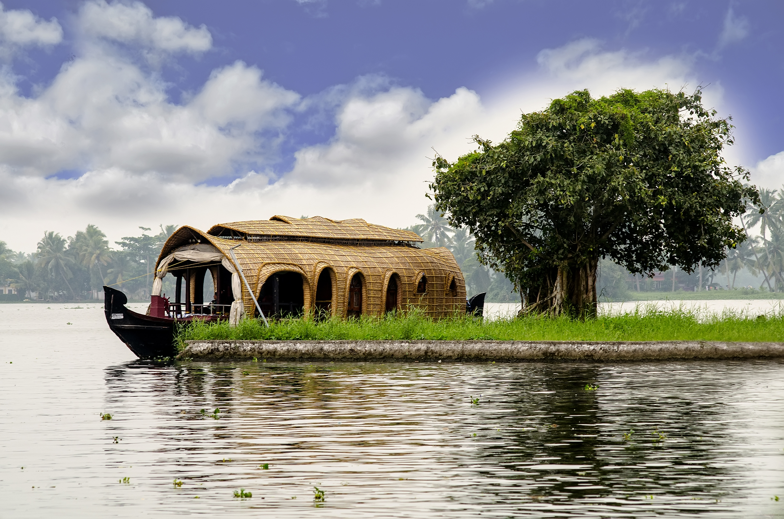
A backwater is a part of a river in which there is little or no current. It can refer to a branch of a main river, which lies alongside it and then rejoins it, or to a body of water in a main river, backed up by the sea tide or by an obstruction such as a dam. Manmade restrictions to natural stream flow or temporary natural obstructions such as ice jams, vegetation blockage, or flooding of a lower stream can create backwater. Alternative channel If a river has developed one or more alternative courses in its evolution, one channel is usually designated the main course, and secondary channels may be termed backwaters. The main river course will usually have the fastest stream and will likely be the main navigation route; backwaters may be shallower and flow more slowly, if at all. Some backwaters are rich in mangrove forest. This results in a more diverse environment of scientific interest and worthy of preservation. Backwaters also provide opportunities for leisure activities s ... [...More Info...] [...Related Items...] OR: [Wikipedia] [Google] [Baidu] |
Rainforest
Rainforests are characterized by a closed and continuous tree canopy, moisture-dependent vegetation, the presence of epiphytes and lianas and the absence of wildfire. Rainforest can be classified as tropical rainforest or temperate rainforest, but other types have been described. Estimates vary from 40% to 75% of all biotic species being indigenous to the rainforests. There may be many millions of species of plants, insects and microorganisms still undiscovered in tropical rainforests. Tropical rainforests have been called the "jewels of the Earth" and the " world's largest pharmacy", because over one quarter of natural medicines have been discovered there. Rainforests as well as endemic rainforest species are rapidly disappearing due to deforestation, the resulting habitat loss and pollution of the atmosphere. Definition Rainforest are characterized by a closed and continuous tree canopy, high humidity, the presence of moisture-dependent vegetation, a moist layer of ... [...More Info...] [...Related Items...] OR: [Wikipedia] [Google] [Baidu] |
Monsoon
A monsoon () is traditionally a seasonal reversing wind accompanied by corresponding changes in precipitation but is now used to describe seasonal changes in atmospheric circulation and precipitation associated with annual latitudinal oscillation of the Intertropical Convergence Zone (ITCZ) between its limits to the north and south of the equator. Usually, the term monsoon is used to refer to the rainy phase of a seasonally changing pattern, although technically there is also a dry phase. The term is also sometimes used to describe locally heavy but short-term rains. The major monsoon systems of the world consist of the West African, Asia–Australian, the North American, and South American monsoons. The term was first used in English in British India and neighboring countries to refer to the big seasonal winds blowing from the Bay of Bengal and Arabian Sea in the southwest bringing heavy rainfall to the area. Etymology The etymology of the word monsoon is not w ... [...More Info...] [...Related Items...] OR: [Wikipedia] [Google] [Baidu] |
Kerala Industrial Infrastructure Development Corporation
Kerala Industrial Infrastructure Development Corporation (KINFRA) is a Public sector undertakings in Kerala, government agency under the Government of Kerala, government of the Indian state of Kerala headquartered in Thiruvananthapuram. It undertakes development of industrial estates to nurture industrialization in the state. Gopala Pillai, Dr. G. C. Gopala Pillai, the former CMD of FACT, Ernakulam was at its helm for the first 12 years and was instrumental in the growth of KINFRA as an industrial facilitator in the state of Kerala. It is now led by S. Ramnath, a protégé of Dr. Pillai. KINFRA plans to set up an industrial park, Kera Park, at Kodakara in Thrissur district. Land acquisition is under way, and the company is awaiting clearances. Since its inception, KINFRA has mainly identified itself with land acquisition and development of industrial infrastructure in the form of parks, townships and zones. With the objective of boosting industrial growth, KINFRA has promoted the ... [...More Info...] [...Related Items...] OR: [Wikipedia] [Google] [Baidu] |
Mogral River
The Mogral River (also known as the Madhuvahini River) is a west-flowing river in the Kasaragod district in the Indian state of Kerala. It is named after Mogral, a coastal village on its northern banks. The river empties into the Arabian Sea at Mogral Puthur. It has a length of 34 kilometers and a drainage area of 132 square kilometers. Course The river originates in the lower foothills of the Western Ghats at the Karadka Reserve Forest in the Kasaragod district. Initially it flows through several hilly towns in the eastern region of Kasargod, namely, Badiyadka, Karadka, Mulleriya, Paika, Edneer and Nekraje. From Nekraje, the river takes a meandering course enters the Malabar plains where passes the towns of Pady, Cherkala, Muttathody, Chettumkuzhy, Shiribagilu, Madhur, Patla, Kannathur, Peral, Mogral and Puthur. Towards Mogral Puthur, the Mogral River empties into the Arabian Sea forming an estuary Lake. Flora and Fauna There is a significant patch of mangroves in ... [...More Info...] [...Related Items...] OR: [Wikipedia] [Google] [Baidu] |
Laccadive Sea
The Laccadive Sea or Lakshadweep Sea is a body of water bordering India (including its Lakshadweep islands), the Maldives, and Sri Lanka. It is located to the southwest of Karnataka, to the west of Kerala and to the south of Tamil Nadu. This warm sea has a stable water temperature through the year and is rich in marine life, the Gulf of Mannar alone hosting about 3,600 species. Mangaluru, Kasaragod, Kannur, Kozhikode, Ponnani, Kochi, Alappuzha, Kollam, Thiruvananthapuram, Tuticorin, Colombo, and Malé are the major cities on the shore of the Laccadive Sea. Kanyakumari, the southernmost tip of peninsular India, also borders this sea. Extent The International Hydrographic Organization defines the limits of the Laccadive Sea as follows: ''On the West.'' A line running from Sadashivgad Lt. on West Coast of India () to Corah Divh () and thence down the West side of the Laccadive and Maldive Archipelagos to the most Southerly point of Addu Atoll in the Maldives. ''O ... [...More Info...] [...Related Items...] OR: [Wikipedia] [Google] [Baidu] |
Konkan
The Konkan ( kok, कोंकण) or Kokan () is a stretch of land by the western coast of India, running from Damaon in the north to Karwar in the south; with the Arabian Sea to the west and the Deccan plateau in the east. The hinterland east of the coast has numerous river valleys and riverine islands among the hilly slopes leading up into the tablelands of the Deccan. The region has been recognised by name, since at least the time of Strabo in the third century C.E., and was a thriving mercantile port with Arab tradesmen from the 10th century. The best-known islands of Konkan are Ilhas de Goa, the site of the Goa state's capital at Panjim, and the seven islands of Bombay, on which lies the capital of the State of Maharashtra. Definition Historically, the limits of Konkan have been flexible, and it has been known by additional names like " Aparanta" and "Gomanchal", the latter being defined as the coastal area between the Daman Ganga River in the north and t ... [...More Info...] [...Related Items...] OR: [Wikipedia] [Google] [Baidu] |
2011 Census Of India
The 2011 Census of India or the 15th Census of India, Indian Census was conducted in two phases, house listing and population enumeration. The House listing phase began on 1 April 2010 and involved the collection of information about all buildings. Information for National Population Register (NPR) was also collected in the first phase, which will be used to issue a 12-digit unique identification number to all registered Indian residents by Aadhaar, Unique Identification Authority of India. The second population enumeration phase was conducted between 9 and 28 February 2011. Census has been conducted in India since 1872 and 2011 marks the first time biometric information was collected. According to the provisional reports released on 31 March 2011, the Indian population increased to 1.21 billion with a decadal growth of 17.70%. Adult literacy rate increased to 74.04% with a decadal growth of 9.21%. The motto of the census was 'Our Census, Our future'. Spread across 28 States of ... [...More Info...] [...Related Items...] OR: [Wikipedia] [Google] [Baidu] |


