|
Paumotu
Tuamotuan, Paumotu or Paumotu (Tuamotuan: ' or ') is a Polynesian language spoken by 4,000 people in the Tuamotu archipelago, with an additional 2,000 speakers in Tahiti. The Tuamotu people today refer to their land as Tuamotu, while referring to themselves and their language as Paʻumotu. Paʻumotu is one of six Polynesian languages spoken in French Polynesia, the other five languages being Tahitian, Marquesan, Mangarevan, Rapa, and Austral. The Paʻumotu alphabet is based on the Latin script. History and culture Little is known regarding the early history of the Tuamotus. It is believed that they were settled c. 700 AD by people from the Society Islands. Europeans first discovered the islands in 1521, when Ferdinand Magellan reached them while sailing across the Pacific Ocean. Subsequent explorers visited the islands over the centuries, including Thor Heyerdahl, the famous Norwegian ethnographer who sailed the Kon-Tiki expedition across the Pacific in 1947. The effe ... [...More Info...] [...Related Items...] OR: [Wikipedia] [Google] [Baidu] |
Tuamotus
The Tuamotu Archipelago or the Tuamotu Islands (french: Îles Tuamotu, officially ) are a French Polynesian chain of just under 80 islands and atolls in the southern Pacific Ocean. They constitute the largest chain of atolls in the world, extending (from northwest to southeast) over an area roughly the size of Western Europe. Their combined land area is . This archipelago's major islands are Anaa, Fakarava, Hao and Makemo. The Tuamotus have approximately 16,000 inhabitants. The islands were initially settled by Polynesians, and modern Tuamotuans have inherited from them a shared culture and the Tuamotuan language. The Tuamotus are a French overseas collectivity. History The early history of the Tuamotu islands is generally unknown. Archaeological findings suggest that the western Tuamotus were settled from the Society Islands as early as 900 CE or as late as 1200 CE. DNA evidence suggests that they were settled about 1110 CE. On the islands of Rangiroa, Manihi and M ... [...More Info...] [...Related Items...] OR: [Wikipedia] [Google] [Baidu] |
Moruroa
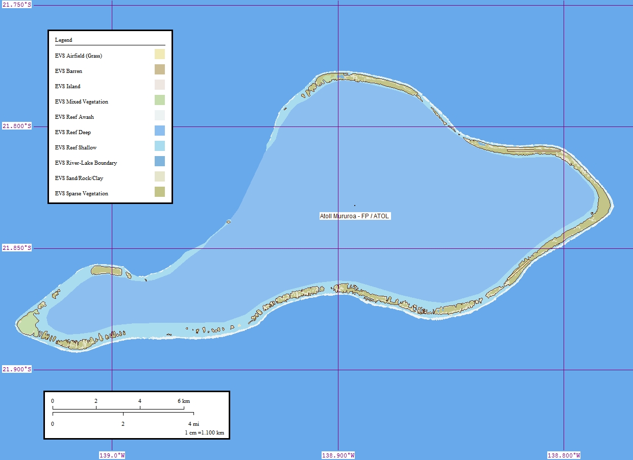
Moruroa (Mururoa, Mururura), also historically known as Aopuni, is an atoll which forms part of the Tuamotu Archipelago in French Polynesia in the southern Pacific Ocean. It is located about southeast of Tahiti. Administratively Moruroa Atoll is part of the commune of Tureia, which includes the atolls of Tureia, Fangataufa, Tematangi and Vanavana. France undertook nuclear weapon tests between 1966 and 1996 at Moruroa and Fangataufa, causing international protests, notably in 1974 and 1995. The number of tests performed on Moruroa has been variously reported as 175 and 181. History Ancient Polynesians knew Mururoa Atoll by the ancestral name of Hiti-Tautau-Mai. The first recorded European to visit this atoll was Commander Philip Carteret on HMS ''Swallow'' in 1767, just a few days after he had discovered Pitcairn Island. Carteret named Mururoa "Bishop of Osnaburgh Island". In 1792, the British whaler was wrecked here, and it became known as Matilda's Rocks. Frederick Will ... [...More Info...] [...Related Items...] OR: [Wikipedia] [Google] [Baidu] |
Mangareva Language
Mangareva, Mangarevan ( autonym , ; in French ) is a Polynesian language spoken by about 600 people in the Gambier Islands of French Polynesia (especially the largest island Mangareva) and on the islands of Tahiti and Moorea, located to the North-West of the Gambier Islands, where Mangarevians have emigrated. Vitality At the 2017 census, only 24.8% of the population age 15 and older in the Gambier Islands still reported that Mangarevan was the language they spoke the most at home (down from 38.6% at the 2007 census), while 62.6% reported French as the main language spoken at home (up from 52.3% at the 2007 census), 4.9% reported Tahitian (down from 6.4% in 2007), and 4.6% reported some Chinese dialects (predominantly Hakka) (up from 3.5% in 2007). The ten years between 2007 and 2017, based on official census numbers, have seen a global decline in the number of Mangarevan-speaking adults (i.e. people aged 15 and older who reported that Mangarevan was the language they spoke the ... [...More Info...] [...Related Items...] OR: [Wikipedia] [Google] [Baidu] |
Polynesian Languages
The Polynesian languages form a genealogical group of languages, itself part of the Oceanic branch of the Austronesian family. There are 38 Polynesian languages, representing 7 percent of the 522 Oceanic languages, and 3 percent of the Austronesian family. While half of them are spoken in geographical Polynesia (the Polynesian triangle), the other half – known as Polynesian outliers – are spoken in other parts of the Pacific: from Micronesia to atolls scattered in Papua New Guinea, the Solomon Islands or Vanuatu. The most prominent Polynesian languages, in number of speakers, are Tahitian, Samoan, Tongan, Māori and Hawaiian. The ancestors of modern Polynesians were Lapita navigators, who settled in the Tonga and Samoa areas about 3,000 years ago. Linguists and archaeologists estimate that this first population went through common development during about 1000 years, giving rise to Proto-Polynesian, the linguistic ancestor of all modern Polynesian languages ... [...More Info...] [...Related Items...] OR: [Wikipedia] [Google] [Baidu] |
Tahitic Languages
The Polynesian languages form a genealogical group of languages, itself part of the Oceanic branch of the Austronesian family. There are 38 Polynesian languages, representing 7 percent of the 522 Oceanic languages, and 3 percent of the Austronesian family. While half of them are spoken in geographical Polynesia (the Polynesian triangle), the other half – known as Polynesian outliers – are spoken in other parts of the Pacific: from Micronesia to atolls scattered in Papua New Guinea, the Solomon Islands or Vanuatu. The most prominent Polynesian languages, in number of speakers, are Tahitian, Samoan, Tongan, Māori and Hawaiian. The ancestors of modern Polynesians were Lapita navigators, who settled in the Tonga and Samoa areas about 3,000 years ago. Linguists and archaeologists estimate that this first population went through common development during about 1000 years, giving rise to Proto-Polynesian, the linguistic ancestor of all modern Polynesian languages. A ... [...More Info...] [...Related Items...] OR: [Wikipedia] [Google] [Baidu] |
French Polynesia
)Territorial motto: ( en, "Great Tahiti of the Golden Haze") , anthem = , song_type = Regional anthem , song = "Ia Ora 'O Tahiti Nui" , image_map = French Polynesia on the globe (French Polynesia centered).svg , map_alt = Location of French Polynesia , map_caption = Location of French Polynesia (circled in red) , mapsize = 290px , subdivision_type = Sovereign state , subdivision_name = , established_title = Protectorate proclaimed , established_date = 9 September 1842 , established_title2 = Territorial status , established_date2 = 27 October 1946 , established_title3 = Collectivity status , established_date3 = 28 March 2003 , established_title4 = Country status (nominal title) , established_date4 = 27 February 2004 , official_languages = French , regional_languages = , capital = Papeete , coordinates = , largest_city = Fa'a'ā , demonym = French Polynesian , ethnic_groups = 66.5% unmixed Polynesians7.1% mixed Polynesians9.3% Demis11 ... [...More Info...] [...Related Items...] OR: [Wikipedia] [Google] [Baidu] |
France And Weapons Of Mass Destruction
France is one of the five "Nuclear Weapons States" under the Treaty on the Non-Proliferation of Nuclear Weapons, but is not known to possess or develop any chemical or biological weapons. France was the fourth country to test an independently developed nuclear weapon, doing so in 1960 under the government of Charles de Gaulle. The French military is currently thought to retain a weapons stockpile of around 300 operational (deployed) nuclear warheads, making it the third-largest in the world, speaking in terms of warheads, not megatons. The weapons are part of the national '' Force de frappe'', developed in the late 1950s and 1960s to give France the ability to distance itself from NATO while having a means of nuclear deterrence under sovereign control. France did not sign the Partial Nuclear Test Ban Treaty, which gave it the option to conduct further nuclear tests until it signed and ratified the Comprehensive Nuclear-Test-Ban Treaty in 1996 and 1998 respectively. France deni ... [...More Info...] [...Related Items...] OR: [Wikipedia] [Google] [Baidu] |
Fangataufa
Fangataufa (or Fangatafoa) is an uninhabited coral atoll in the eastern part of the Tuamotu Archipelago in French Polynesia. The atoll has been fully-owned by the French state since 1964. From 1966 to 1996 it was used as a nuclear test site by the French government. In total, 4 atmospheric and 10 underground nuclear explosions were carried out on the atoll. Geography The atoll is a coral outgrowth of a seamount which rises some from the seafloor, to a depth of . The seamount was formed 33.4 - 34.7 million years ago by the Pitcairn hotspot. The island is approx. long and wide. It has a lagoon area of and a land area of . It is located south of Moruroa atoll, east of Tematangi, southwest of the Gambier Islands and southeast of Tahiti. Access to the lagoon is through a pass lying SW of the northernmost point of the atoll; the channel has a width of about and a dredged depth of . A quay, in of water, is situated in the NE part of the lagoon; another quay, long in of wat ... [...More Info...] [...Related Items...] OR: [Wikipedia] [Google] [Baidu] |
Atlas
An atlas is a collection of maps; it is typically a bundle of maps of Earth or of a region of Earth. Atlases have traditionally been bound into book form, but today many atlases are in multimedia formats. In addition to presenting geographic features and political boundaries, many atlases often feature geopolitical, social, religious and economic statistics. They also have information about the map and places in it. Etymology The use of the word "atlas" in a geographical context dates from 1595 when the German-Flemish geographer Gerardus Mercator published ("Atlas or cosmographical meditations upon the creation of the universe and the universe as created"). This title provides Mercator's definition of the word as a description of the creation and form of the whole universe, not simply as a collection of maps. The volume that was published posthumously one year after his death is a wide-ranging text but, as the editions evolved, it became simply a collection of maps and ... [...More Info...] [...Related Items...] OR: [Wikipedia] [Google] [Baidu] |


