|
Oulujoki
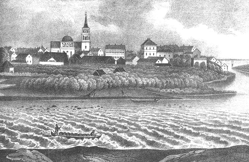
Oulujoki () is a river in North Ostrobothnia, Finland. Its name in Finnish literally means "Oulu River", originally in old Northern Ostrobothnian dialect literally "Flood River". Its origin is Oulujärvi, and its watershed area covers a significant part of Kainuu region. It flows into the Bothnian Bay at Oulu Oulu ( , ; ) is a city in Finland and the regional capital of North Ostrobothnia. It is located on the northwestern coast of the country at the mouth of the Oulujoki, River Oulu. The population of Oulu is approximately , while the Oulu sub-regio .... Port of Oulu is located at the mouth of the river. External links * Rivers of Finland Rivers of Muhos Rivers of Oulu {{Finland-river-stub ... [...More Info...] [...Related Items...] OR: [Wikipedia] [Google] [Baidu] |
Oulu
Oulu ( , ; ) is a city in Finland and the regional capital of North Ostrobothnia. It is located on the northwestern coast of the country at the mouth of the Oulujoki, River Oulu. The population of Oulu is approximately , while the Oulu sub-region, sub-region has a population of approximately . It is the most populous Municipalities of Finland, municipality in Finland, and the fourth most populous List of urban areas in Finland by population, urban area in the country. Oulu is also the most populous city in Northern Finland. Oulu's neighbouring municipalities are: Hailuoto, Ii, Finland, Ii, Kempele, Liminka, Lumijoki, Muhos, Pudasjärvi, Tyrnävä and Utajärvi. Oulu is the third northernmost city in the world with a population of over 100,000, after Murmansk and Norilsk in Russia. Due to its large population and geopolitical, economic and cultural-historical position, Oulu has been called the "capital of Northern Finland". Oulu is also considered one of Europe's "living labs", ... [...More Info...] [...Related Items...] OR: [Wikipedia] [Google] [Baidu] |
Oulujärvi
Oulujärvi () or Lake Oulu or Ule (), is a large lake in the Kainuu region of Finland. It is also historically known as Lake Cajania from a former name of Kainuu.. With an area of it is the List of lakes of Finland, fifth largest lake in the country. The lake is drained by the Oulujoki, Oulu River, which flows northwestward from the lake into the Gulf of Bothnia. Its nickname is the "Kainuu Sea", and it is bordered by the three Municipalities of Finland, municipalities of Vaala, Paltamo, and Kajaani. About 40 percent of the lake is in Vaala. See also *Mulkkusaaret References External links *Oulujarvi, Official tourism website Oulujärvi, Oulujoki basin Landforms of Kainuu {{OuluProvince-geo-stub ... [...More Info...] [...Related Items...] OR: [Wikipedia] [Google] [Baidu] |
Port Of Oulu
Port of Oulu (''Oulun satama'' in Finnish) is a complex of three separate harbours located at the mouth of Oulujoki river in Oulu, Finland. Port of Oulu is a corporation owned by the City of Oulu. Annual average of 3 million tons of cargo is shipped on 500 vessels. Two of the ports, Nuottasaari and Oritkari, are also rail-served. Harbours in Port of Oulu Vihreäsaari oil and bulk docks Vihreäsaari oil docks on Vihreäsaari island, on the north bank of Oulujoki river is the most important oil dock in the city, with a maximum allowed draught of 10.0m. In addition to oil handling facilities there are six-ton bulk cranes in Vihreäsaari. The harbour was opened in 1963 Nuottasaari docks Located next to the Stora Enso paper mill on the south bank of the river is the Nuottasaari docks with three separate piers: the main pier and two separate chemical piers. Maximum allowed draught in 6.4m. Two cranes of 8-ton and 6-ton capacities are in service. The harbour was opened in 1953 Ori ... [...More Info...] [...Related Items...] OR: [Wikipedia] [Google] [Baidu] |
Vaala
Vaala () is a municipality in Finland. It is located in the North Ostrobothnia regions of Finland, region. Established in 1954 (predecessor municipality ''Säräisniemi'', established in 1867), the municipality has a population of () and covers an area of of which is water. The population density is . Previously Vaala was part of the Kainuu region but was transferred to Northern Ostrobothnia on 1 January 2016. Half of Oulujärvi, the fifth largest lake of Finland is located in Vaala. The municipality is unilingually Finnish language, Finnish. Vaala is also an old Finnish word, which means the phase in a river just before rapids. History The original center of the area was Manamansalo, the largest island in the Oulujärvi with a village by the same name. Both it and Säräisniemi were first mentioned in 1555 when they were parts of the large Liminka parish. The parish of Oulujärvi, covering all of Kainuu with its center in Manamansalo, was separated from Liminka in 1559, ... [...More Info...] [...Related Items...] OR: [Wikipedia] [Google] [Baidu] |
Bothnian Bay
The Bothnian Bay or Bay of Bothnia (; ) is the northernmost part of the Gulf of Bothnia, which is in turn the northern part of the Baltic Sea. The land holding the bay is still rising after the weight of ice-age glaciers has been removed, and within 2,000 years the bay will be a large freshwater lake since its link to the south Kvarken is mostly less than deep. The bay today is fed by several large rivers, and is relatively unaffected by tides, so has low salinity. It freezes over each year for up to six months. Compared to other parts of the Baltic, it has little plant or animal life. Extent The bay is divided from the Bothnian Sea, the southern part of the Gulf of Bothnia, by the Northern Quark ( Kvarken) strait. The Northern Quark has a greatest depth of , with two ridges that are just deep. It lies between a group of islands off Vaasa in Finland and another group at Holmöarna in Sweden. The bay is bounded by Finland to the east and Sweden to the west. The bay is asymm ... [...More Info...] [...Related Items...] OR: [Wikipedia] [Google] [Baidu] |
Rivers Of Finland
This is a list of rivers of Finland. Listing begins with rivers flowing into the Baltic sea, from the north, that is from the Swedish border. Tributaries are listed down the page in an upstream direction. Water flows from Finland directly to the Baltic Sea, which is divided here into the Gulf of Bothnia and Gulf of Finland, and the Archipelago Sea between them. Some rivers flow to Russia, ending either to Gulf of Finland or to the White Sea, and a few to the Arctic Ocean through Russia or Norway. There are many lakes in Finland and this listing also includes several lakes through which the rivers flow or begin from. Due to the great number of lakes especially in the Finnish Lakeland, where watercourses tend to consist of chains of lakes rather than long rivers, some rivers with a large catchment area can also be quite short or there may only be a short rapid between large lakes, like for example Tammerkoski in Tampere. Rivers flowing to the Gulf of Bothnia * Torne River (, , i ... [...More Info...] [...Related Items...] OR: [Wikipedia] [Google] [Baidu] |
Finland
Finland, officially the Republic of Finland, is a Nordic country in Northern Europe. It borders Sweden to the northwest, Norway to the north, and Russia to the east, with the Gulf of Bothnia to the west and the Gulf of Finland to the south, opposite Estonia. Finland has a population of 5.6 million. Its capital and largest city is Helsinki. The majority of the population are Finns, ethnic Finns. The official languages are Finnish language, Finnish and Swedish language, Swedish; 84.1 percent of the population speak the first as their mother tongue and 5.1 percent the latter. Finland's climate varies from humid continental climate, humid continental in the south to boreal climate, boreal in the north. The land cover is predominantly boreal forest biome, with List of lakes of Finland, more than 180,000 recorded lakes. Finland was first settled around 9000 BC after the Last Glacial Period, last Ice Age. During the Stone Age, various cultures emerged, distinguished by differen ... [...More Info...] [...Related Items...] OR: [Wikipedia] [Google] [Baidu] |
North Ostrobothnia
North Ostrobothnia (; ) is a Regions of Finland, region of Finland. It borders the Finnish regions of Lapland (Finland), Lapland, Kainuu, Northern Savonia, North Savo, Central Finland and Central Ostrobothnia, as well as the Russian Republic of Karelia. The easternmost corner of the region between Lapland, Kainuu and the Russian border is known as Koillismaa ("North-East Finland"). Historical provinces Municipalities The region of North Ostrobothnia consists of 30 municipalities of Finland, municipalities, 11 of which have city status (marked in bold). Map of municipalities Sub-regions Koillismaa, Koillismaa sub-region * Kuusamo * Taivalkoski Nivala-Haapajärvi sub-region * Haapajärvi * Kärsämäki * Nivala * Pyhäjärvi * Reisjärvi Oulu sub-region * Hailuoto * Kempele * Liminka * Lumijoki * Muhos * Oulu * Tyrnävä Oulunkaari, Oulunkaari sub-region * Ii, Finland, Ii * Pudasjärvi * Utajärvi * Vaala Raahe sub-region * Pyh ... [...More Info...] [...Related Items...] OR: [Wikipedia] [Google] [Baidu] |
Kainuu
Kainuu (), also historically known as Cajania (), is one of the 19 regions of Finland (''maakunta'' / ''landskap''). Kainuu borders the regions of North Ostrobothnia, North Savo and North Karelia. In the east, it also borders Russia (Republic of Karelia). Culturally Kainuu is part of larger Eastern-Finnish cultural heritage. The dialect of Kainuu resembles Savonian and Karelian dialects. Geography Boreal forest makes up most of the biome in Kainuu. The forest in Kainuu mostly consists of birches, pines and spruces. The atypical regional geography and landscape consist of lakes, hills and vast uninhabited forest areas. The largest lake in the region is the Oulujärvi (928.09 km2), one of the largest lakes in Finland. Its shorelines, open waters and islands in Kainuu belong to the municipalities of Paltamo and Kajaani. The highest point in Kainuu is the Iso Tuomivaara (385 m), located in the municipality of Hyrynsalmi. The regional climate is continental. The three mos ... [...More Info...] [...Related Items...] OR: [Wikipedia] [Google] [Baidu] |
Rivers Of Muhos
A river is a natural stream of fresh water that flows on land or inside caves towards another body of water at a lower elevation, such as an ocean, lake, or another river. A river may run dry before reaching the end of its course if it runs out of water, or only flow during certain seasons. Rivers are regulated by the water cycle, the processes by which water moves around the Earth. Water first enters rivers through precipitation, whether from rainfall, the runoff of water down a slope, the melting of glaciers or snow, or seepage from aquifers beneath the surface of the Earth. Rivers flow in channeled watercourses and merge in confluences to form drainage basins, or catchments, areas where surface water eventually flows to a common outlet. Rivers have a great effect on the landscape around them. They may regularly overflow their banks and flood the surrounding area, spreading nutrients to the surrounding area. Sediment or alluvium carried by rivers shapes the landscape aro ... [...More Info...] [...Related Items...] OR: [Wikipedia] [Google] [Baidu] |


