|
Oquirrh Mountains
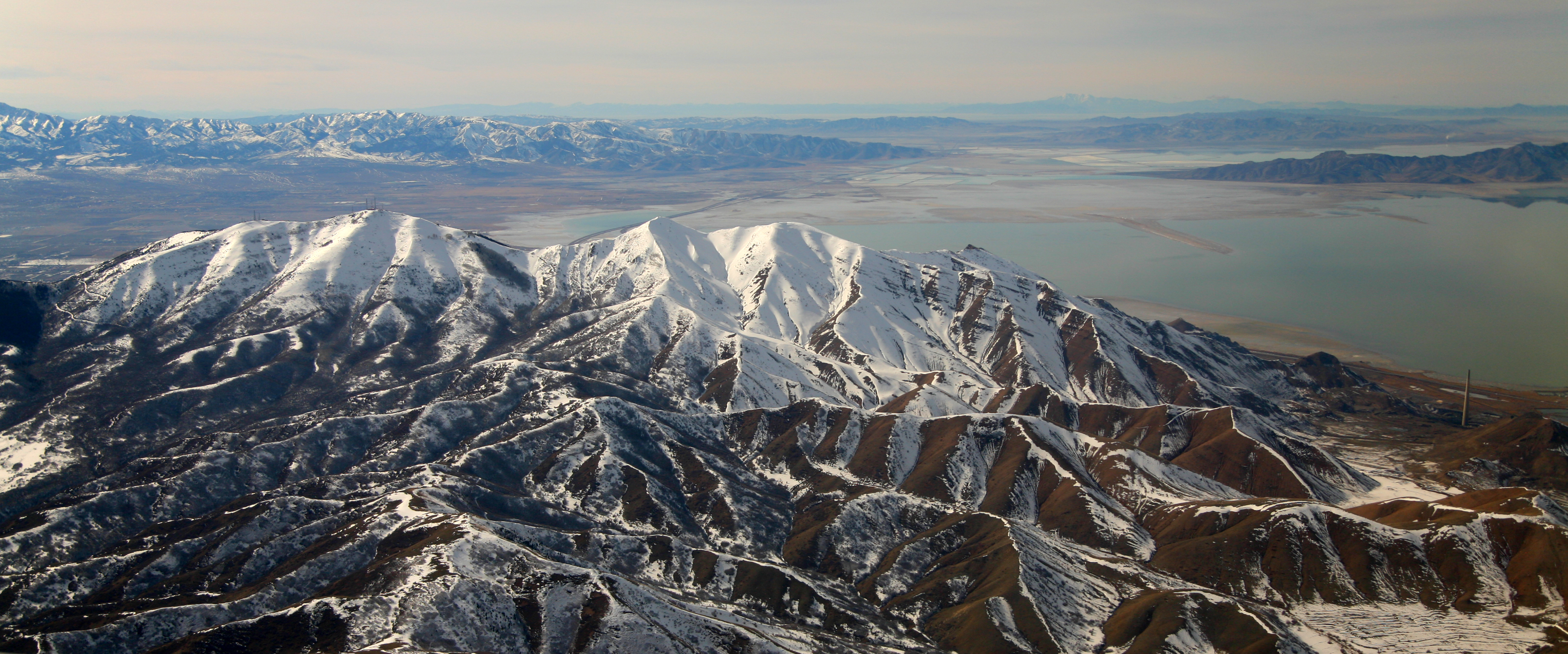
The Oquirrh Mountains is a mountain range that runs north-south for approximately 30 miles (50 km) to form the west side of Utah's Salt Lake Valley, separating it from Tooele Valley. The range runs from northwestern Utah County–central & eastern Tooele County, to the south shore of the Great Salt Lake. The highest elevation is Flat Top Mountain at 10,620 ft (3,237 m). The name Oquirrh was taken from the Goshute word meaning "wood sitting."William Bright, ed. ''Native American Placenames of the United States'' (2004, University of Oklahoma Press) The Oquirrh Mountains have been mined for gold, silver, lead, and most famously for copper, as home of the porphyry copper deposit at Bingham Canyon Mine, one of the world's largest open pit mines. As seen from Salt Lake City, the view of the mountain range is dominated by the displaced rock material (known as overburden) dug from the Kennecott mine. At the north end of the range is Kennecott's smelter complex, which refi ... [...More Info...] [...Related Items...] OR: [Wikipedia] [Google] [Baidu] |
Salt Lake County, Utah
Salt Lake County is located in the U.S. state of Utah. As of the 2020 United States Census, the population was 1,185,238, making it the most populous county in Utah. Its county seat and largest city is Salt Lake City, the state capital. The county was created in 1850. Salt Lake County is the 37th most populated county in the United States and is one of four counties in the Rocky Mountains to make it into the top 100. (Others being Denver County and El Paso County, Colorado and Clark County, Nevada.) Salt Lake County is the only county of the first class in Utah - under the Utah Code (Title 17, Chapter 50, Part 5) is a county with a population of 700,000 or greater. Salt Lake County occupies the Salt Lake Valley, as well as parts of the surrounding mountains, the Oquirrh Mountains to the west and the Wasatch Range to the east (essentially the entire Jordan River watershed north of the Traverse Mountains). In addition, the northwestern section of the county includes part o ... [...More Info...] [...Related Items...] OR: [Wikipedia] [Google] [Baidu] |
Copper
Copper is a chemical element with the symbol Cu (from la, cuprum) and atomic number 29. It is a soft, malleable, and ductile metal with very high thermal and electrical conductivity. A freshly exposed surface of pure copper has a pinkish-orange color. Copper is used as a conductor of heat and electricity, as a building material, and as a constituent of various metal alloys, such as sterling silver used in jewelry, cupronickel used to make marine hardware and coins, and constantan used in strain gauges and thermocouples for temperature measurement. Copper is one of the few metals that can occur in nature in a directly usable metallic form (native metals). This led to very early human use in several regions, from circa 8000 BC. Thousands of years later, it was the first metal to be smelted from sulfide ores, circa 5000 BC; the first metal to be cast into a shape in a mold, c. 4000 BC; and the first metal to be purposely alloyed with another metal, tin, to create br ... [...More Info...] [...Related Items...] OR: [Wikipedia] [Google] [Baidu] |
Television
Television, sometimes shortened to TV, is a telecommunication Media (communication), medium for transmitting moving images and sound. The term can refer to a television set, or the medium of Transmission (telecommunications), television transmission. Television is a mass medium for advertising, entertainment, news, and sports. Television became available in crude experimental forms in the late 1920s, but only after several years of further development was the new technology marketed to consumers. After World War II, an improved form of black-and-white television broadcasting became popular in the United Kingdom and the United States, and television sets became commonplace in homes, businesses, and institutions. During the 1950s, television was the primary medium for influencing public opinion.Diggs-Brown, Barbara (2011''Strategic Public Relations: Audience Focused Practice''p. 48 In the mid-1960s, color broadcasting was introduced in the U.S. and most other developed countri ... [...More Info...] [...Related Items...] OR: [Wikipedia] [Google] [Baidu] |
Frequency Modulation
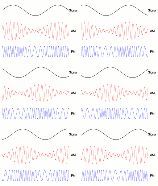
Frequency modulation (FM) is the encoding of information in a carrier wave by varying the instantaneous frequency of the wave. The technology is used in telecommunications, radio broadcasting, signal processing, and Run-length limited#FM: .280.2C1.29 RLL, computing. In Analog signal, analog frequency modulation, such as radio broadcasting, of an audio signal representing voice or music, the instantaneous frequency deviation, i.e. the difference between the frequency of the carrier and its center frequency, has a functional relation to the modulating signal amplitude. Digital data can be encoded and transmitted with a type of frequency modulation known as frequency-shift keying (FSK), in which the instantaneous frequency of the carrier is shifted among a set of frequencies. The frequencies may represent digits, such as '0' and '1'. FSK is widely used in computer modems, such as fax modems, telephone caller ID systems, garage door openers, and other low-frequency transmissions. R ... [...More Info...] [...Related Items...] OR: [Wikipedia] [Google] [Baidu] |
Farnsworth Peak
Farnsworth Peak is a peak located on the northern end of the Oquirrh Mountain range, approximately south west of Salt Lake City, Utah, United States. The mountain is named for Philo Farnsworth, the inventor of the first completely electronic television. It is used mainly for radio and television transmission, but could potentially become part of a ski resort owned by nearby Kennecott Land. On the eastern side of the mountain, the land is completely private, and access is restricted. The peak can be reached by hiking from the Tooele side, which is mostly public land. The Bureau of Land Management land extends from Ridge Peak west to the base of the mountain. Public access to this land is available off SR-36 near Lake Point. Several cattle gates need to be opened and closed, but are access roads to hiking, mountain biking, and horseback riding areas. Radio and television use Farnsworth Peak, in local radio terms, refers to three separate radio transmitter sites. They are know ... [...More Info...] [...Related Items...] OR: [Wikipedia] [Google] [Baidu] |
Herriman, Utah
Herriman ( ) is a city in southwestern Salt Lake County, Utah. The population was 55,144 as of the 2020 census. Although Herriman was a town in 2000, it has since been classified as a fourth-class city by state law. The city has experienced rapid growth since incorporation in 1999, as its population was just 1,523 at the 2000 census. It grew from being the 111th-largest incorporated place in Utah in 2000 to the 14th-largest in 2020. History Founding Herriman was established in 1851 by Henry Harriman, Thomas Jefferson Butterfield, John Jay Stocking, and Robert Cowan Petty. A fort was established where the community garden is today. The only remnants of Fort Herriman are the two black locust trees that stand where the entrance to the fort once was. The Fort was abandoned in 1857 as the Johnston Army came West. Incorporation Herriman remained a small community until 1999, when proactive citizens, including Brett Wood and J. Lynn Crane, went door to door asking people to sign ... [...More Info...] [...Related Items...] OR: [Wikipedia] [Google] [Baidu] |
Tooele, Utah
Tooele ( ) is a city in Tooele County in the U.S. state of Utah. The population was 35,742 at the 2020 census. It is the county seat of Tooele County. Located approximately 30 minutes southwest of Salt Lake City, Tooele is known for Tooele Army Depot, for its views of the nearby Oquirrh Mountains and the Great Salt Lake. History The Tooele Valley was the traditional territory of the Tooele Valley Goshute, a band of the Goshute Shoshone. The ancient presence of humans in the area is attested by extensive archaeological work at the Danger Cave site, which confirms people were present and active by 9000 BP 000 BC When Mormon pioneers entered the Great Salt Lake Valley in July 1847, it was covered with abundant tall grass. The Mormons first used the valley as wintering grounds for their herds. In September 1849, three families settled on a small stream south of present-day Tooele City. Other families slowly joined them, and by 1853 Tooele City Corporation was organized. Duri ... [...More Info...] [...Related Items...] OR: [Wikipedia] [Google] [Baidu] |
Butterfield Canyon (Utah)
Butterfield Canyon is a canyon in the Oquirrh Mountains in southwest Salt Lake County, Utah, United States, located just west of the city of Herriman. Locals use this canyon to commute to and from Herriman/Tooele. Butterfield Canyon Road is a recreation road. The canyon was named after Thomas Jefferson Butterfield, the founder of Herriman, Utah. Description Butterfield Canyon contains a paved road owned by Kennecott Utah Copper (Butterfield Canyon Road - closed Nov 1 to June 1). Butterfield Canyon road climbs to a summit of above sea level. Past the summit, when it becomes Middle Canyon Road on the Tooele County side of the mountain, there is a portion that is well-maintained dirt. When roads on both sides of the mountain are open, they connect the city of Tooele with Herriman. The canyon was discovered in 1851 when Thomas Butterfield & Samuel Egbert, two men from West Jordan, were searching for an area to raise livestock and their families and found a stream of water flowing ... [...More Info...] [...Related Items...] OR: [Wikipedia] [Google] [Baidu] |
Stockton, Utah
Stockton is a town in Tooele County, Utah, United States. It is part of the Salt Lake City, Utah Metropolitan Statistical Area. The population was 616 at the 2010 census. History Stockton was born of the first mining boom in the Utah Territory. The mining industry began in the early 1860s with the arrival of Col. Patrick E. Connor, commander of the Third California Volunteers, who had been sent to the territory in 1862 to keep an eye on the overland mail routes during the Civil War. Connor wanted to counterbalance his perceived dominance of Mormon leaders in the area by exploring and developing the territory's mineral wealth. He posited that if precious metals could be discovered in Utah, the resulting flood of miners into the territory would overwhelm the Mormons, and outsiders would balance the Church's power. So he sent the men under his command out to prospect, and they almost singlehandedly opened the precious metals industry in Utah in 1863 by locating deposits, stakin ... [...More Info...] [...Related Items...] OR: [Wikipedia] [Google] [Baidu] |
Bald Eagle
The bald eagle (''Haliaeetus leucocephalus'') is a bird of prey found in North America. A sea eagle, it has two known subspecies and forms a species pair with the white-tailed eagle (''Haliaeetus albicilla''), which occupies the same niche as the bald eagle in the Palearctic. Its range includes most of Canada and Alaska, all of the contiguous United States, and northern Mexico. It is found near large bodies of open water with an abundant food supply and old-growth trees for nesting. The bald eagle is an opportunistic feeder which subsists mainly on fish, which it swoops down upon and snatches from the water with its talons. It builds the largest nest of any North American bird and the largest tree nests ever recorded for any animal species, up to deep, wide, and in weight. Sexual maturity is attained at the age of four to five years. Bald eagles are not actually bald; the name derives from an older meaning of the word, "white headed". The adult is mainly brown with ... [...More Info...] [...Related Items...] OR: [Wikipedia] [Google] [Baidu] |
Interstate 80 In Utah
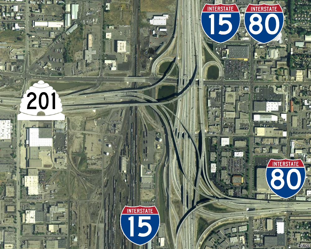
Interstate 80 (I-80) is a part of the Interstate Highway System that runs from San Francisco, California, to Teaneck, New Jersey. The portion of the highway in the US state of Utah is long through the northern part of the state. From west to east, I-80 crosses the state line from Nevada in Tooele County and traverses the Bonneville Salt Flats—which are a part of the larger Great Salt Lake Desert. It continues alongside the Wendover Cut-off—the corridor of the former Victory Highway— US Route 40 (US-40) and the Western Pacific Railroad Feather River Route. After passing the Oquirrh Mountains, I-80 enters the Salt Lake Valley and Salt Lake County. A short portion of the freeway is concurrent with I-15 through Downtown Salt Lake City. At the Spaghetti Bowl, I-80 turns east again into the mouth of Parleys Canyon and Summit County, travels through the mountain range, and intersects the eastern end of I-84 near Echo Reservoir before turning northeast toward ... [...More Info...] [...Related Items...] OR: [Wikipedia] [Google] [Baidu] |
Overburden
In mining, overburden (also called waste or spoil) is the material that lies above an area that lends itself to economical exploitation, such as the rock, soil, and ecosystem that lies above a coal seam or ore body. Overburden is distinct from tailings, the material that remains after economically valuable components have been extracted from the generally finely milled ore. Overburden is removed during surface mining, but is typically not contaminated with toxic components. Overburden may also be used to restore an exhausted mining site during reclamation. Interburden is material that lies between two areas of economic interest, such as the material separating coal seams within strata.Peng, Syd S. (1986) ''Coal Mine Ground Control'' (2nd edition), Wiley, New York, page 303, Analogous uses Overburden is also used for all soil and ancillary material above the bedrock horizon in a given area. By analogy, overburden is also used to describe the soil and other material that lies ... [...More Info...] [...Related Items...] OR: [Wikipedia] [Google] [Baidu] |


.jpg)

