|
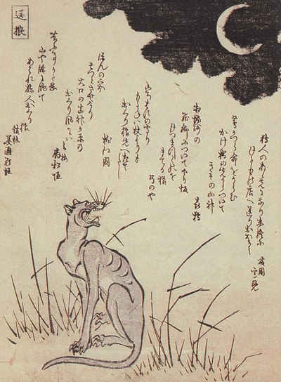
Okuri-inu
The (literally, 'escorting dog') is a kind of yōkai. There are stories of the okuri-inu from the Tōhoku region to Kyushu, but depending on the area it can be a wolf not a dog, and there are numerous differences in its behaviour. It is sometimes also called simply the 'yama-inu' () (wild dog, wolf) or the 'ōkami' ( (wolf). Characteristics The okuri-inu closely follows people who are walking along mountain paths at nighttime. If by chance the person falls over they will be immediately eaten up, but if they pretend to be having a short rest they will not be attacked. It is important not to look too tired, though. These features are common to every region, but the dog's behaviour does sometimes vary – for instance in some places it is said that the okuri-inu will charge into you, and if you fall a pack of dogs will quickly appear and attack you. There are also regions that have stories about what happens once you safely make it to the end of the mountain path. For example, one ... [...More Info...] [...Related Items...] OR: [Wikipedia] [Google] [Baidu] |
Japanese Wolf
The Japanese wolf ( ja, ニホンオオカミ(日本狼), ja, script=Latn, label= Hepburn, Nihon ōkami, or , below]; ''Canis lupus hodophilax''), also known as the Honshū wolf, is an extinct subspecies of the gray wolf that was once endemic to the islands of Honshū, Shikoku and Kyūshū in the Japanese archipelago. It was one of two subspecies that were once found in the Japanese archipelago, the other being the Hokkaido wolf. Phylogenetic evidence indicates that Japanese wolf was the last surviving wild member of the Pleistocene wolf lineage (in contrast to the Hokkaido wolf which belonged to the lineage of the modern day gray wolf), and may have been the closest wild relative of the domestic dog. Many dog breeds originating from Japan also have Japanese wolf DNA from past hybridization. Despite long being revered in Japan, the introduction of rabies and canine distemper to Japan led to the decimation of the population, and policies enacted during the Meiji Restoration ... [...More Info...] [...Related Items...] OR: [Wikipedia] [Google] [Baidu] |
List Of Legendary Creatures From Japan
The following is a list of demons, ghosts, and other legendary creatures that are notable in Japanese folklore and mythology. A B C D E F G H I J K M N O R S T ... [...More Info...] [...Related Items...] OR: [Wikipedia] [Google] [Baidu] |
Yōkai
are a class of supernatural entities and spirits in Japanese folklore. The word is composed of the kanji for "attractive; calamity" and "apparition; mystery; suspicious." are also referred to as , or . Despite often being translated as such, are not literally demons in the Western sense of the word, but are instead spirits and entities. Their behavior can range from malevolent or mischievous to benevolent to humans. often have animal features (such as the , depicted as appearing similar to a turtle, and the , commonly depicted with wings), but may also appear humanoid in appearance, such as the . Some resemble inanimate objects (such as the ), while others have no discernible shape. are typically described as having spiritual or supernatural abilities, with shapeshifting being the most common trait associated with them. that shapeshift are known as or . Japanese folklorists and historians explain as personifications of "supernatural or unaccountable phenomena ... [...More Info...] [...Related Items...] OR: [Wikipedia] [Google] [Baidu] |
Tōhoku Region
The , Northeast region, or consists of the northeastern portion of Honshu, the largest island of Japan. This traditional region consists of six prefectures (''ken''): Akita, Aomori, Fukushima, Iwate, Miyagi, and Yamagata. Tōhoku retains a reputation as a remote, scenic region with a harsh climate. In the 20th century, tourism became a major industry in the Tōhoku region. History Ancient & Classical period In mythological times, the area was known as Azuma (吾妻, あづま) and corresponded to the area of Honshu occupied by the native Emishi and Ainu. The area was historically the Dewa and the Michinoku regions, a term first recorded in (654). There is some variation in modern usage of the term "Michinoku". Tōhoku's initial historical settlement occurred between the seventh and ninth centuries, well after Japanese civilization and culture had become firmly established in central and southwestern Japan. The last stronghold of the indigenous Emishi on Hons ... [...More Info...] [...Related Items...] OR: [Wikipedia] [Google] [Baidu] |
Kyushu
is the third-largest island of Japan's five main islands and the most southerly of the four largest islands ( i.e. excluding Okinawa). In the past, it has been known as , and . The historical regional name referred to Kyushu and its surrounding islands. Kyushu has a land area of and a population of 14,311,224 in 2018. In the 8th-century Taihō Code reforms, Dazaifu was established as a special administrative term for the region. Geography The island is mountainous, and Japan's most active volcano, Mount Aso at , is on Kyushu. There are many other signs of tectonic activity, including numerous areas of hot springs. The most famous of these are in Beppu, on the east shore, and around Mt. Aso in central Kyushu. The island is separated from Honshu by the Kanmon Straits. Being the nearest island to the Asian continent, historically it is the gateway to Japan. The total area is which makes it the 37th largest island in the world. It's slightly larger than Taiwan is ... [...More Info...] [...Related Items...] OR: [Wikipedia] [Google] [Baidu] |
Chiisagata District
is a district located in Nagano Prefecture, Japan. Population As of February 1, 2006, the district has an estimated population of 12,039. The total area is now down to 241.04 km2. There are only one town and one village left in the district: Aoki and Nagawa. History *January 14, 1879 - Due to the district, ward, town and village status enforcement, the district seat was located at the town of Ueda. *April 1, 1889 - Due to enforcing the town and village status, Chiisagata District formed the towns of Ueda, Nagakuboshin, and Nagakubofuru, and 32 villages (3 towns, 32 villages) *October 30, 1912 - The village of Maruko gained town status. (4 towns, 31 villages) *May 1, 1919 - The town of Ueda gained city status which lasted until March 6, 2006. (3 towns, 31 villages) *September 10, 1921 - The village of Sakashita merged into the city of Ueda. (3 towns, 30 villages) *September 1, 1949 - The villages of Higashishiota and Fujisan merged to form the village of Higashishiota. ... [...More Info...] [...Related Items...] OR: [Wikipedia] [Google] [Baidu] |
Shōwa Period
Shōwa may refer to: * Hirohito (1901–1989), the 124th Emperor of Japan, known posthumously as Emperor Shōwa * Showa Corporation, a Japanese suspension and shock manufacturer, affiliated with the Honda keiretsu Japanese eras * Jōwa (Heian period) (承和), alternatively read as Shōwa, from 834 to 848 * Shōwa (Kamakura period) (正和), from 1312 to 1317 * Shōwa (1926–1989) (昭和), from 1926 to 1989 Japanese places * Shōwa, Akita, a former town in Akita Prefecture * Shōwa, Yamanashi, a town in Yamanashi Prefecture * Shōwa, a former town in Tokyo, now part of Akishima, Tokyo * Shōwa-ku, a ward of Nagoya, Aichi Prefecture * Shōwa, Fukushima, a village in Fukushima Prefecture * Shōwa, Gunma, a village in Gunma Prefecture * Shōwa, Saitama, a dissolved town in Saitama Prefecture * Showa Station (Antarctica), a Japanese research station located in Antarctica Japanese educational institutions * Showa University, in Tokyo * Showa Women's University, in Tokyo ... [...More Info...] [...Related Items...] OR: [Wikipedia] [Google] [Baidu] |
Ueda, Nagano
is a city located in Nagano Prefecture, Japan. , the city had an estimated population of 157,480 in 67,783 households, and a population density of 290 persons per km2. The total area of the city is , which makes it the fifth largest city in Nagano Prefecture in terms of area. Geography Ueda is located in central Nagano Prefecture, some 40 kilometers from the prefectural capital of Nagano City and 190 kilometers from Tokyo. The Chikuma River divides the city into two parts. Surrounding municipalities *Nagano Prefecture ** Matsumoto ** Tōmi ** Suzaka ** Nagano ** Chikuma ** Nagawa ** Aoki ** Chikuhoku * Gunma Prefecture ** Tsumagoi Climate The city has a climate characterized by hot and humid summers, and relatively mild winters (Köppen climate classification ''Cwa''). The average annual temperature in Ueda is . The average annual rainfall is with September as the wettest month. The temperatures are highest on average in August, at around , and lowest in January, at ... [...More Info...] [...Related Items...] OR: [Wikipedia] [Google] [Baidu] |
Koumi
is a town located in Nagano Prefecture, Japan. , the town had an estimated population of 4,676 in 2012 households, and a population density of 41 persons per km². The total area of the town is . The town mascot is "Ptylitza", an imaginary small gnome-like creature, images of which can be seen all over the town. Geography Koumi is located in the far east of Nagano. The nearest city is Saku, about 40 minutes drive away. Nagano city is about 100 km away. Mount Tengu (2646 meters) is located on the border of Koumi with Chino. the Chikuma River flows through the town. Surrounding municipalities *Nagano Prefecture ** Chino ** Minamimaki **Kitaaiki **Minamiaiki ** Sakuho Climate The town has a humid continental climate characterized by warm and humid summers, and cold winters with heavy snowfall (Köppen climate classification ''Dfb''). The average annual temperature in Koumi is 8.2 °C. The average annual rainfall is 1398 mm with September as the wettest month. T ... [...More Info...] [...Related Items...] OR: [Wikipedia] [Google] [Baidu] |
Kantō Region
The is a geographical area of Honshu, the largest island of Japan. In a common definition, the region includes the Greater Tokyo Area and encompasses seven prefectures: Gunma, Tochigi, Ibaraki, Saitama, Tokyo, Chiba and Kanagawa. Slightly more than 45 percent of the land area within its boundaries is the Kanto Plain. The rest consists of the hills and mountains that form land borders with other regions of Japan. As the Kanto region contains Tokyo, the capital and largest city of Japan, the region is considered the center of Japan's politics and economy. According to the official census on October 1, 2010, by the Japan Statistics Bureau, the population was 42,607,376, amounting to approximately one third of the total population of Japan. Other definitions The Kantō regional governors' association (関東地方知事会, ''Kantō chihō chijikai'') assembles the prefectural governors of Ibaraki, Tochigi, Gunma, Saitama, Chiba, Tokyo, Kanagawa, Yamanashi, Nag ... [...More Info...] [...Related Items...] OR: [Wikipedia] [Google] [Baidu] |
Kinki Region
The or the , lies in the southern-central region of Japan's main island Honshū. The region includes the prefectures of Nara, Wakayama, Kyoto, Osaka, Hyōgo and Shiga, often also Mie, sometimes Fukui, Tokushima and Tottori. The metropolitan region of Osaka, Kobe and Kyoto (Keihanshin region) is the second-most populated in Japan after the Greater Tokyo Area. Name The terms , , and have their roots during the Asuka period. When the old provinces of Japan were established, several provinces in the area around the then-capital Kyoto were collectively named Kinai and Kinki, both roughly meaning "the neighbourhood of the capital". Kansai (literally ''west of the tollgate'') in its original usage refers to the land west of the Osaka Tollgate (), the border between Yamashiro Province and Ōmi Province (present-day Kyoto and Shiga prefectures).Entry for . Kōjien, fifth edition, 1998, During the Kamakura period, this border was redefined to include Ōmi and Iga Provinces. I ... [...More Info...] [...Related Items...] OR: [Wikipedia] [Google] [Baidu] |


