|
Odžak
Odžak ( sr-cyrl, Оџак) is a town and municipality located in Posavina Canton of the Federation of Bosnia and Herzegovina, an entity of Bosnia and Herzegovina. It is situated in the northern part of Bosnia and Herzegovina, near the river Sava, from the border with Croatia. The name is derived from Turkish ''Ocak'', during its time as a frontier town of the Ottoman Empire, and means "fireplace" in Turkish and "chimney" in modern Bosnian. The town of Odžak is notable for being the battlegrounds of the last battle in Europe of World War II, fought between the Croatian Ustaše and Yugoslav Partisans. History Roman & Medieval era During the Roman era, there was a settlement and a fortress about 670 meters long in the area of the Odžak municipality, discovered by Karlo Mać. These are the remains of a large Roman city named Ad Basante (near Bosna). At that time, the Bosna River flowed beside today's mosque, and the city was right on the shore. It was necessary for the ... [...More Info...] [...Related Items...] OR: [Wikipedia] [Google] [Baidu] |
Posavina Canton
The Posavina Canton (; Serbian and ; cyrl, Посавски кантон) is one of ten cantons of the Federation of Bosnia and Herzegovina in Bosnia and Herzegovina. It is the smallest canton with an area of only . The canton is an exclave of Federation of Bosnia and Herzegovina, being bordered by Republika Srpska and Brčko District to the south and the river Sava and Croatia to the north. Its capital is Orašje and the largest town is Odžak. History The Posavina area was inhabited since prehistoric times, as evidenced by various archaeological finds of coins and other artifacts. After the 1718 Treaty of Passarowitz between the Ottoman Empire and Habsburg monarchy, mostly Catholic families from mountain villages were displaced across the plains, as the Turks themselves settled in the hills and valleys. The Croats from Županja, Babina Greda and Štitar moved to the villages of Kopanice, Vidovice, Tolisa and Domaljevac. The current municipalities of Derventa and B ... [...More Info...] [...Related Items...] OR: [Wikipedia] [Google] [Baidu] |
Battle Of Odžak
The Battle of Odžak was the last battle of World War II in Europe Europe is a continent located entirely in the Northern Hemisphere and mostly in the Eastern Hemisphere. It is bordered by the Arctic Ocean to the north, the Atlantic Ocean to the west, the Mediterranean Sea to the south, and Asia to the east .... The battle began on 19 April 1945 and lasted until 25 May 1945, 17 days after the end of the war in Europe. The combatants were the Croatian Armed Forces (Independent State of Croatia) (NDH) commanded by Petar Rajkovačić and the Yugoslav Army commanded by Miloš Zekić. The battle took place in the Bosnian town of Odžak. The battle was a victory for the Partisans. The battle is thoroughly described in a number of books, for example, in a 1969 book on 53rd Division, 1981 book on 16th Muslim Brigade, 1983 book on 27th East Bosnian Division, and 1983 book on 14th Central Bosnian Brigade. File:"Vlaška Mala" from 23rd to 28th of April 1945.jpg, alt=, Operation ... [...More Info...] [...Related Items...] OR: [Wikipedia] [Google] [Baidu] |
Ustaše
The Ustaše (), also known by anglicised versions Ustasha or Ustashe, was a Croats, Croatian fascist and ultranationalist organization active, as one organization, between 1929 and 1945, formally known as the Ustaša – Croatian Revolutionary Movement (). From its inception and before the World War II, Second World War, the organization engaged in a series of terrorist activities against the Kingdom of Yugoslavia, including collaborating with Internal Macedonian Revolutionary Organization, IMRO to assassinate King Alexander I of Yugoslavia#Assassination of Alexander I, Alexander I of Yugoslavia in 1934.The Assassination of Europe, 1918-1942: A Political History, Howard M. Sachar, University of Toronto Press, 2014, , pp. 251–258. During World War II in Yugoslavia, the Ustaše went on to perpetrate The Holocaust in the Independent State of Croatia, the Holocaust and genocide against its Jews, Jewish, Genocide of Serbs in the Independent State of Croatia, Serb and Romani Holoca ... [...More Info...] [...Related Items...] OR: [Wikipedia] [Google] [Baidu] |
Posavina
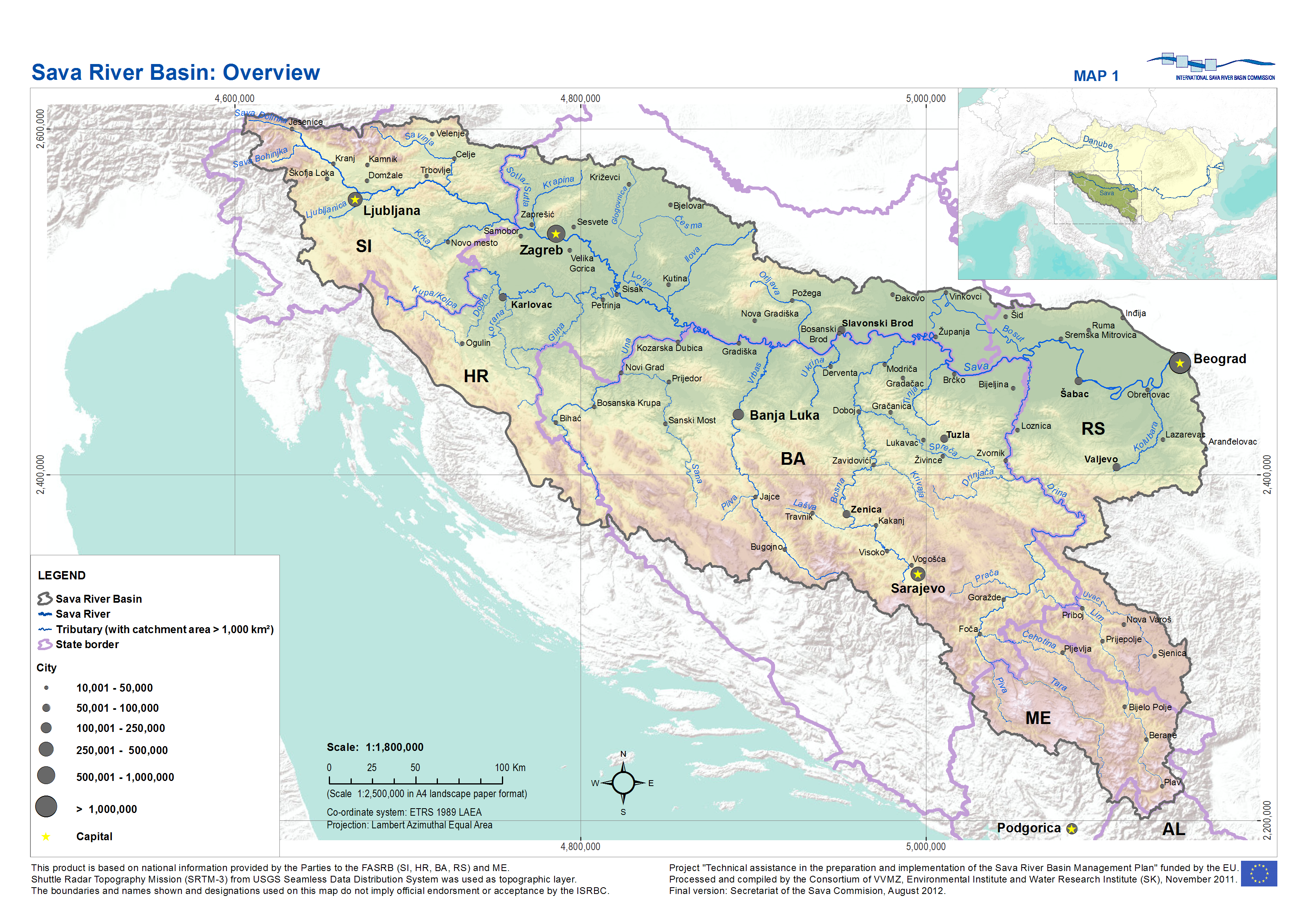
Posavina ( sr-cyr, Посавина) is a geographical region that stretches along the Sava river, encompassing only the inner areas of the Sava river basin, that are adjacent or near to the Sava river itself, namely catch region spanning from the Julian Alps in the northwest to the confluence with the Danube in the southeast. It passes through several countries of former Yugoslavia, namely Slovenia, Croatia, Bosnia and Herzegovina and Serbia. In Slovene, the term Posavina is not used to describe the parts of Slovenia that lie by the Sava river. Instead, the terms Posavje, Zasavje and Zgornjesavska dolina are used (however, the parts of Slovenia between Litija and Bled, as well as Bohinj, are generally not defined by their proximity to the Sava river in Slovenian geographical nomenclature). Geography The geography of the Posavina region is defined by geological features of the central (inner) zones of the Sava river basin, near or adjacent to the Sava river itself. ... [...More Info...] [...Related Items...] OR: [Wikipedia] [Google] [Baidu] |
Municipalities Of Bosnia And Herzegovina
In Bosnia and Herzegovina, the smallest administrative unit is the municipality ("''opština''/општина" or "''općina''/опћина" in the official languages and scripts of the country). Prior to the 1992–95 Bosnian War there were 109 municipalities in what was then Socialist Republic of Bosnia and Herzegovina. Ten of these formed the area of the capital Sarajevo. After the war, the number of municipalities was increased to 143, grouped in the following way: *79 municipalities constitute the Federation of Bosnia and Herzegovina (FBiH), which comprises 51% of the country's total territory. The municipalities within the federation are grouped into ten cantons. *64 municipalities constitute the Republika Srpska (RS), which comprises 49% of the country's total territory. In addition, Brčko District does not belong to either entity and is governed as a condominium of both FBiH and RS entities. The district corresponds to the pre-war Brčko municipality. Although tec ... [...More Info...] [...Related Items...] OR: [Wikipedia] [Google] [Baidu] |
Rome
Rome (Italian language, Italian and , ) is the capital city and most populated (municipality) of Italy. It is also the administrative centre of the Lazio Regions of Italy, region and of the Metropolitan City of Rome. A special named with 2,746,984 residents in , Rome is the list of cities in the European Union by population within city limits, third most populous city in the European Union by population within city limits. The Metropolitan City of Rome Capital, with a population of 4,223,885 residents, is the most populous metropolitan cities of Italy, metropolitan city in Italy. Rome metropolitan area, Its metropolitan area is the third-most populous within Italy. Rome is located in the central-western portion of the Italian Peninsula, within Lazio (Latium), along the shores of the Tiber Valley. Vatican City (the smallest country in the world and headquarters of the worldwide Catholic Church under the governance of the Holy See) is an independent country inside the city boun ... [...More Info...] [...Related Items...] OR: [Wikipedia] [Google] [Baidu] |
Tabula Peutingeriana
' (Latin Language, Latin for 'The Peutinger Map'), also known as Peutinger's Tabula, Peutinger tablesJames Strong (theologian) , James Strong and John McClintock (theologian) , John McClintock (1880)"Eleutheropolis" In: ''The Cyclopedia of Biblical, Theological, and Ecclesiastical Literature''. NY: Haper and Brothers. Accessed 30 August 2024 via biblicalcyclopedia.com. and Peutinger Table, is an illustrated ' (ancient Roman road map) showing the layout of the ''cursus publicus'', the road network of the Roman Empire. The map is a parchment copy, dating from around 1200, of a Late antiquity, Late Antique original. It covers Europe (without the Iberian Peninsula and the British Isles), North Africa, and parts of Asia, including the Middle East, Persia, and the Indian subcontinent. According to one hypothesis, the existing map is based on a document of the 4th or 5th century that contained a copy of the world map originally prepared by Marcus Vipsanius Agrippa, Agrippa during the re ... [...More Info...] [...Related Items...] OR: [Wikipedia] [Google] [Baidu] |
Constantinople
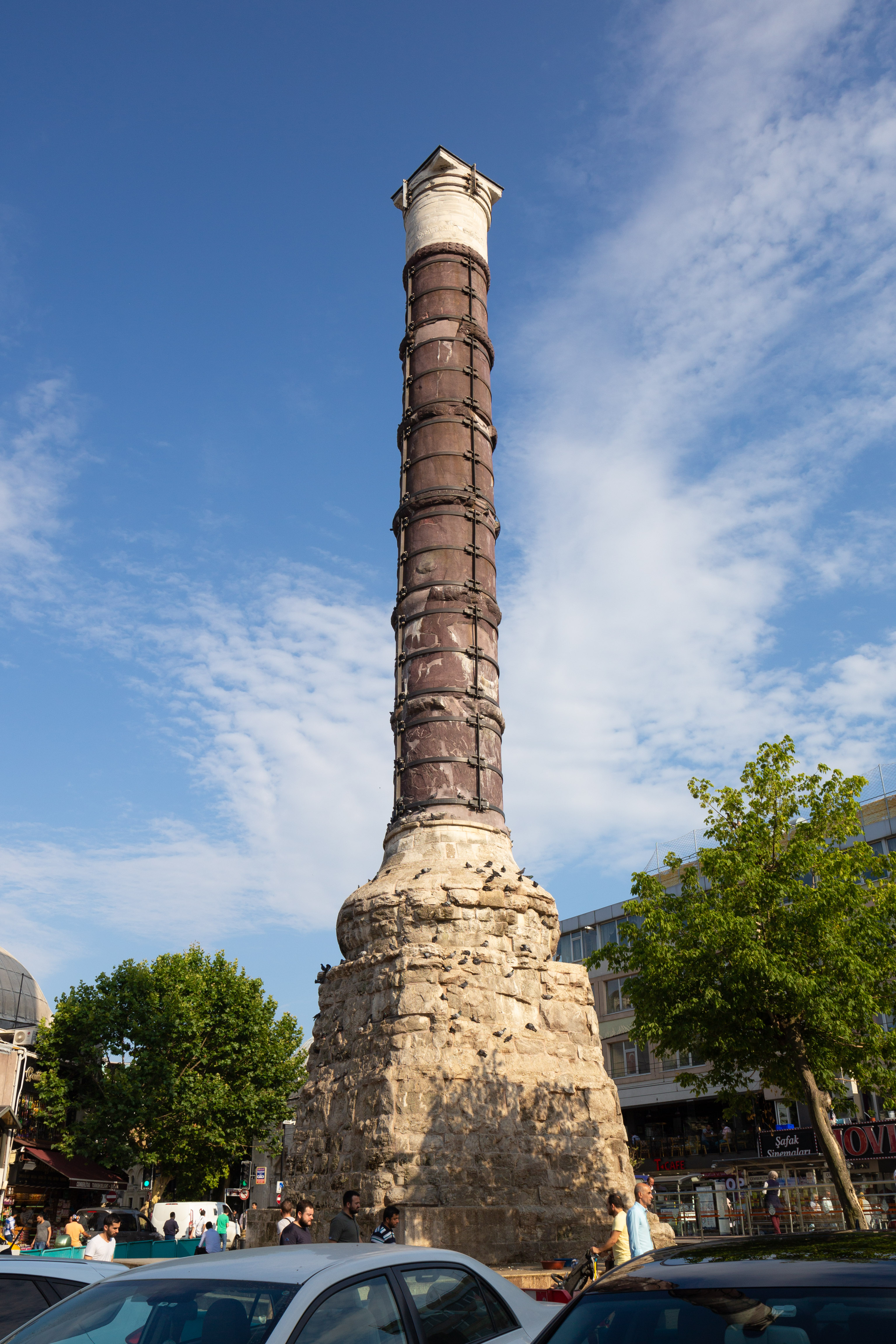
Constantinople (#Names of Constantinople, see other names) was a historical city located on the Bosporus that served as the capital of the Roman Empire, Roman, Byzantine Empire, Byzantine, Latin Empire, Latin, and Ottoman Empire, Ottoman empires between its consecration in 330 until 1930, when it was renamed to Istanbul. Initially as New Rome, Constantinople was founded in 324 during the reign of Constantine the Great on the site of the existing settlement of Byzantium, and shortly thereafter in 330 became the capital of the Roman Empire. Following the collapse of the Western Roman Empire in the late 5th century, Constantinople remained the capital of the Eastern Roman Empire (also known as the Byzantine Empire; 330–1204 and 1261–1453), the Latin Empire (1204–1261), and the Ottoman Empire (1453–1922). Following the Turkish War of Independence, the Turkish capital then moved to Ankara. Although the city had been known as Istanbul since 1453, it was officially renamed as Is ... [...More Info...] [...Related Items...] OR: [Wikipedia] [Google] [Baidu] |
Punic Wars
The Punic Wars were a series of wars fought between the Roman Republic and the Ancient Carthage, Carthaginian Empire during the period 264 to 146BC. Three such wars took place, involving a total of forty-three years of warfare on both land and sea across the western Mediterranean region, and a four-year-long Mercenary War, revolt against Carthage. The First Punic War broke out on the Mediterranean island of Sicily in 264BC as a result of Rome's expansionary attitude combined with Carthage's proprietary approach to the island. At the start of the war Carthage was the dominant power of the western Mediterranean, with an extensive maritime empire (a thalassocracy), while Rome was a rapidly expanding power in Roman Italy, Italy, with a strong Roman army of the mid-Republic, army but no navy. The fighting took place primarily on Sicily and its surrounding waters, as well as in North Africa, Corsica and Sardinia. It lasted twenty-three years, until 241BC, when the Carthaginians were ... [...More Info...] [...Related Items...] OR: [Wikipedia] [Google] [Baidu] |
Slavonski Brod
Slavonski Brod (, ), commonly shortened to simply Brod, is a city in eastern Croatia, near the border with Bosnia and Herzegovina. Being one of the principal cities in the historical regions of Slavonia and Posavina, Slavonski Brod is the 7th largest city in the country, with a population of 59,141 at the 2011 census. It is the centre of Brod-Posavina County and a major river port on the Sava river. Names Although ''brod'' means 'ship' in modern Croatian language, Croatian, the city's name bears witness to an older meaning - 'water crossing', 'Ford (crossing), ford'. Among the names historically in use: ''Marsonia'' in the Roman Empire, ''Brood'' (in Slawonien) in the German speaking Austrian period, ''Brod na Savi'' after 1934. The ancient name "Marsonia" probably comes from the Proto-Indo-European word *mory (marsh), and the same root is seen in the nearby toponyms such as "Mursa" and "Mariniana". Geography The city is located southeast of Zagreb and at an elevation of . It ... [...More Info...] [...Related Items...] OR: [Wikipedia] [Google] [Baidu] |
Adriatic Sea
The Adriatic Sea () is a body of water separating the Italian Peninsula from the Balkans, Balkan Peninsula. The Adriatic is the northernmost arm of the Mediterranean Sea, extending from the Strait of Otranto (where it connects to the Ionian Sea) to the northwest and the Po Valley. The countries with coasts on the Adriatic are Albania, Bosnia and Herzegovina, Croatia, Italy, Montenegro, and Slovenia. The Adriatic contains more than 1,300 islands, mostly located along its eastern coast. It is divided into three basins, the northern being the shallowest and the southern being the deepest, with a maximum depth of . The prevailing currents flow counterclockwise from the Strait of Otranto. Tidal movements in the Adriatic are slight, although acqua alta, larger amplitudes occur occasionally. The Adriatic's salinity is lower than the Mediterranean's because it collects a third of the fresh water flowing into the Mediterranean, acting as a dilution basin. The surface water temperatures ... [...More Info...] [...Related Items...] OR: [Wikipedia] [Google] [Baidu] |
Fruška Gora
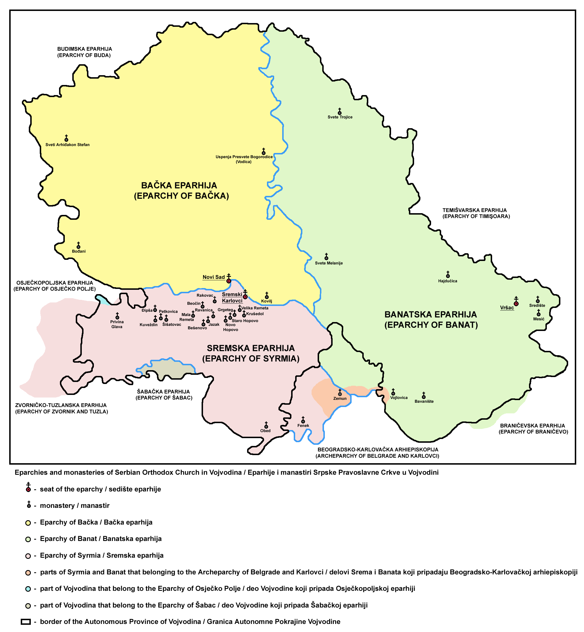
Fruška gora ( sr-Cyrl, Фрушка гора) is a mountain in Syrmia, with most of the mountain being part of Serbia and its westernmost edge extending into eastern Croatia. The Serbian part of the mountain forms the country's oldest National parks of Serbia, national park. Sometimes also referred to as the ''Jewel of Serbia'', due to its largely pristine landscape and protection effort, or the ''Serbian Mount Athos'', being the home of a large number of historical Serbian Orthodox monasteries. Name In Serbian language, Serbian, it is known as ''Fruška gora'' (, Фрушка гора), in Hungarian language, Hungarian as ''Tarcal'' (also ''Almus-hegy'' or ''Árpatarló''), in German language, German as ''Frankenwald'', and in Latin language, Latin as ''Alma Mons''. In Medieval Greek, it was known as ''Frangochoria''. The mountain's name originates in the old Serbian language, Serbian word ''"Fruzi"'' derived from the singular form ''"Frug"''; and its adjective is ''Fruški'', ... [...More Info...] [...Related Items...] OR: [Wikipedia] [Google] [Baidu] |


