|
North Kivu
North Kivu (french: link=no, Nord-Kivu) is a province bordering Lake Kivu in the eastern Democratic Republic of the Congo. Its capital is Goma. North Kivu borders the provinces of Ituri to the north, Tshopo to the northwest, Maniema to the southwest, and South Kivu to the south. To the east, it borders the countries of Uganda and Rwanda. The province consists of three cities—Goma, Butembo and Beni—and six territories— Beni, Lubero, Masisi, Rutshuru, Nyiragongo and Walikale. It is home to the Virunga National Park, a World Heritage Site containing the endangered mountain gorillas. The region is politically unstable and since 1998 has been one of the flashpoints of the military conflicts in the region. North Kivu was the site of an Ebola epidemic, which was compounded by political instability in the region. History The frontiers of the Congo Free State were defined by the Neutrality Act during the 1885 Berlin Conference, in which the European powers staked out the ... [...More Info...] [...Related Items...] OR: [Wikipedia] [Google] [Baidu] |
Provinces Of The Democratic Republic Of The Congo
Article 2 of the Constitution of the Democratic Republic of the Congo divides the country into the capital city of Kinshasa and 25 named provinces. It also gives the capital the status of a province. Therefore, in many contexts Kinshasa is regarded as the 26th province. List History When Belgium annexed the Belgian Congo as a colony in November 1908, it was initially organised into 22 districts. Ten western districts were administered directly by the main colonial government, while the eastern part of the colony was administered under two vice-governments: eight northeastern districts formed Orientale Province, and four southeastern districts formed Katanga. In 1919, the colony was organised into four provinces: * Congo-Kasaï (five southwestern districts), * Équateur (five northwestern districts), * Orientale Province and Katanga (previous vice-governments). [...More Info...] [...Related Items...] OR: [Wikipedia] [Google] [Baidu] |
Beni Territory
Beni Territory is a territory in North Kivu, Democratic Republic of the Congo. It has been the site of fighting during the Allied Democratic Forces insurgency between government troops and the ADF militia, which also crosses the border into the territory from Uganda }), is a landlocked country in East Africa. The country is bordered to the east by Kenya, to the north by South Sudan, to the west by the Democratic Republic of the Congo, to the south-west by Rwanda, and to the south by Tanzania. The sou .... France24, 6 November 2019. References {{coord, 0.4833, N, 29.4500, E, source:wikidata-and-enwiki-cat-tree_region:CD, display=title[...More Info...] [...Related Items...] OR: [Wikipedia] [Google] [Baidu] |
Ruzizi River
The Ruzizi (also sometimes spelled Rusizi) is a river, long, that flows from Lake Kivu to Lake Tanganyika in Central Africa, descending from about to about above sea level over its length. The steepest gradients occur over the first , where hydroelectric dams have been built. Further downstream, the Ruzizi Plain, the floor of the Western Rift Valley, has gentle hills, and the river flows into Lake Tanganyika through a delta, with one or two small channels splitting off from the main channel. The Ruzizi is a young river, formed about 10,000 years ago when volcanism associated with continental rifting created the Virunga Mountains. The mountains blocked Lake Kivu's former outlet to the drainage basin of the Nile and instead forced the lake overflow south down the Ruzizi and the drainage basin of the Congo. Course Along its upstream reaches, the river forms part of the border between Rwanda on the east with the Democratic Republic of the Congo (DRC) on the west. Further down ... [...More Info...] [...Related Items...] OR: [Wikipedia] [Google] [Baidu] |
Lake Tanganyika
Lake Tanganyika () is an African Great Lake. It is the second-oldest freshwater lake in the world, the second-largest by volume, and the second-deepest, in all cases after Lake Baikal in Siberia. It is the world's longest freshwater lake. The lake is shared among four countries—Tanzania, the Democratic Republic of the Congo (DRC), Burundi, and Zambia, with Tanzania (46%) and DRC (40%) possessing the majority of the lake. It drains into the Congo River system and ultimately into the Atlantic Ocean. Etymology "Tanganika" was the name of the lake that Henry Morton Stanley encountered when he was at Ujiji in 1876. The name first originated from the Bembe language when they arrived in South Kivu around the 7th century, they discovered the lake and started calling it “êtanga ‘ya’ni’â” which means “a big river” in their Bantu language. Stanley found also other names for the lake among different ethnic groups, like the Kimana, the Yemba and the Msaga. An altern ... [...More Info...] [...Related Items...] OR: [Wikipedia] [Google] [Baidu] |
Berlin Conference
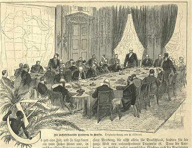
The Berlin Conference of 1884–1885, also known as the Congo Conference (, ) or West Africa Conference (, ), regulated European colonisation and trade in Africa during the New Imperialism period and coincided with Germany's sudden emergence as an imperial power. The conference was organized by Otto von Bismarck, the first chancellor of Germany. Its outcome, the General Act of the Berlin Conference, can be seen as the formalisation of the Scramble for Africa, but some historians warn against an overemphasis of its role in the colonial partitioning of Africa, and draw attention to bilateral agreements concluded before and after the conference. The conference contributed to ushering in a period of heightened colonial activity by European powers, which eliminated or overrode most existing forms of African autonomy and self-governance. Of the fourteen countries being represented, six of them – Austria-Hungary, Russia, Denmark, the Netherlands, Sweden–Norway, and the Un ... [...More Info...] [...Related Items...] OR: [Wikipedia] [Google] [Baidu] |
Congo Free State
''(Work and Progress) , national_anthem = Vers l'avenir , capital = Vivi Boma , currency = Congo Free State franc , religion = Catholicism (''de facto'') , leader1 = Leopold II of Belgium , year_leader1 = 1885–1908 , title_leader = Sovereign , representative1 = F. W. de Winton , year_representative1 = 1885–1886 , representative2 = Théophile Wahis , year_representative2 = 1900–1908 , title_representative = Governor-General , today = Democratic Republic of the Congo , demonym = , area_km2 = 2,345,409 , area_rank = , percent_water = 3.32 , population_estimate = 9,130,000 , population_estimate_year = 1907 , population_density_km2 = 3.8 , GDP_PPP = , GDP_PPP_year = , HDI = , HDI_year = The Congo Free State, al ... [...More Info...] [...Related Items...] OR: [Wikipedia] [Google] [Baidu] |
2018–19 Kivu Ebola Epidemic
The Kivu Ebola epidemic was an outbreak of Ebola virus disease (EVD) that ravaged the eastern Democratic Republic of the Congo (DRC) in Central Africa from 2018 to 2020. Between 1 August 2018 and 25 June 2020 it resulted in 3,470 reported cases. The Kivu outbreak also affected Ituri Province, whose first case was confirmed on 13 August 2018. In November 2018, the outbreak became the biggest Ebola outbreak in the DRC's history, and had become the second-largest Ebola outbreak in recorded history worldwide, behind only the 2013–2016 Western Africa epidemic. In June 2019, the virus reached Uganda, having infected a 5-year-old Congolese boy who entered Uganda with his family, but was contained. A military conflict in the region that had begun in January 2015 hindered treatment and prevention efforts. The World Health Organization (WHO) described the combination of military conflict and civilian distress as a potential "perfect storm" that could lead to a rapid worsening of the o ... [...More Info...] [...Related Items...] OR: [Wikipedia] [Google] [Baidu] |
Mountain Gorilla
The mountain gorilla (''Gorilla beringei beringei'') is one of the two subspecies of the eastern gorilla. It is listed as endangered by the IUCN as of 2018. There are two populations: One is found in the Virunga volcanic mountains of Central/ East Africa, within three National Parks: Mgahinga, in southwest Uganda; Volcanoes, in northwest Rwanda; and Virunga, in the eastern Democratic Republic of Congo (DRC). The other population is found in Uganda's Bwindi Impenetrable National Park. Some primatologists speculate the Bwindi population is a separate subspecies, though no description has been finalized. As of June 2018, there were more than 1,000 individuals. Evolution, taxonomy, and classification Mountain gorillas are descendants of ancestral monkeys and apes found in Africa and Arabia during the start of the Oligocene epoch (34–24 million years ago). The fossil record provides evidence of the hominoid primates (apes) found in east Africa approximately 22–32 m ... [...More Info...] [...Related Items...] OR: [Wikipedia] [Google] [Baidu] |
World Heritage Site
A World Heritage Site is a landmark or area with legal protection by an international convention administered by the United Nations Educational, Scientific and Cultural Organization (UNESCO). World Heritage Sites are designated by UNESCO for having cultural, historical, scientific or other form of significance. The sites are judged to contain " cultural and natural heritage around the world considered to be of outstanding value to humanity". To be selected, a World Heritage Site must be a somehow unique landmark which is geographically and historically identifiable and has special cultural or physical significance. For example, World Heritage Sites might be ancient ruins or historical structures, buildings, cities, deserts, forests, islands, lakes, monuments, mountains, or wilderness areas. A World Heritage Site may signify a remarkable accomplishment of humanity, and serve as evidence of our intellectual history on the planet, or it might be a place of great natural beauty. ... [...More Info...] [...Related Items...] OR: [Wikipedia] [Google] [Baidu] |
Virunga National Park
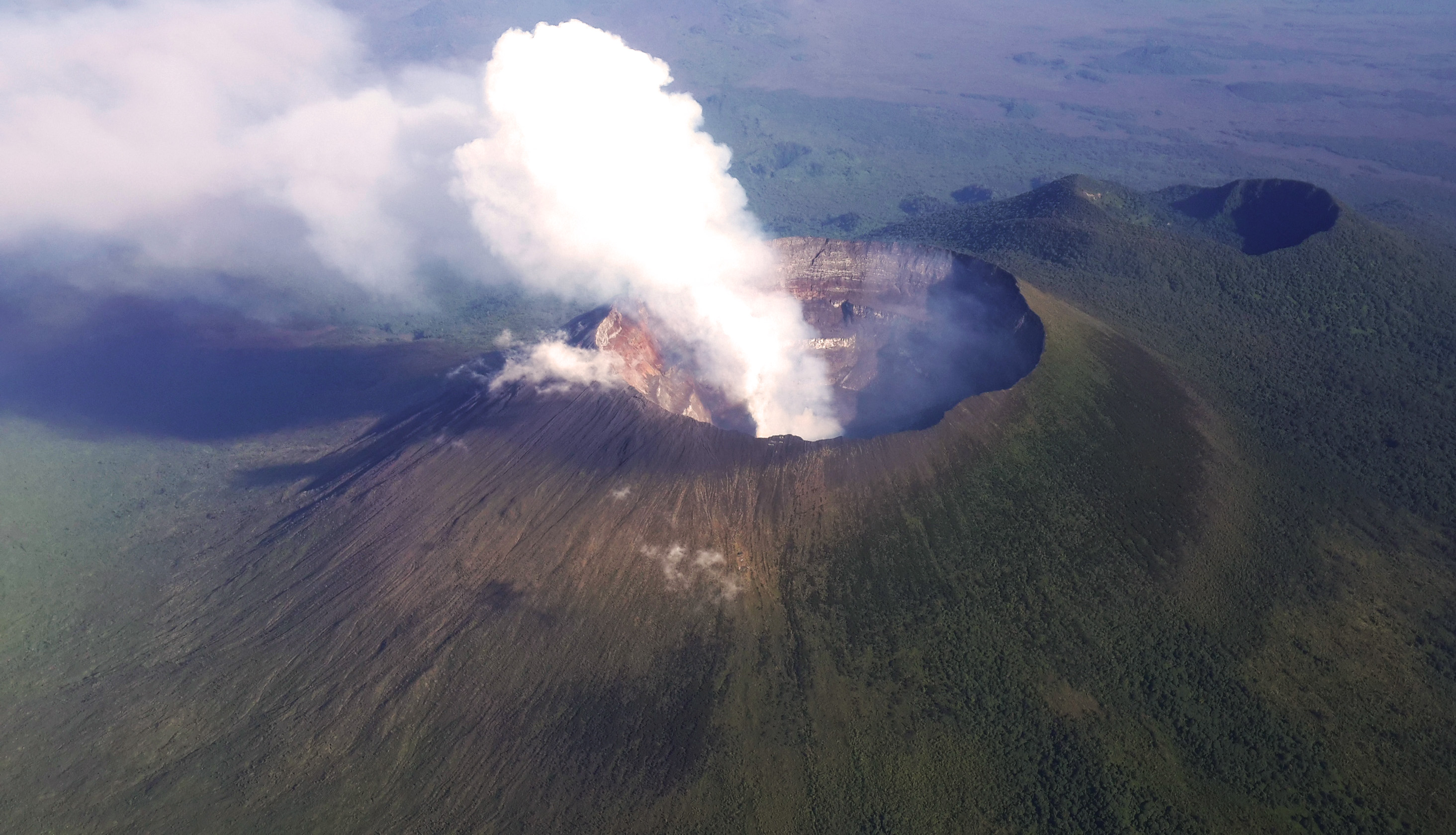
, iucn_category = II , iucn_ref = , location = Democratic Republic of the Congo , map = Democratic Republic of the Congo , relief = 1 , coordinates = , area = , established = , nearest_city = Goma , photo =Virunga National Park-107997.jpg , photo_caption = , governing_body = Institut Congolais pour la Conservation de la Nature , website = , administrator =Emmanuel de Merode , embedded1 = , embedded2 = , visitation_num = , visitation_year = Virunga National Park is a national park in the Albertine Rift Valley in the eastern part of the Democratic Republic of the Congo. It was created in 1925. In elevation, it ranges from in the Semliki River valley to in the Rwenzori Mountains. From north to south it extends approximately , largely along the international borders with Uganda and Rwanda in the east. It covers an area of . Two active volcanoes are located in the park, Mount Nyiragongo and Nyamuragira. They have significantly shaped the national park's ... [...More Info...] [...Related Items...] OR: [Wikipedia] [Google] [Baidu] |
Walikale Territory
Walikale Territory is a territory located within the Congolese province of North Kivu, in the eastern regions of the Democratic Republic of the Congo. The headquarters are in the town of Walikale. The locality is situated between Bukavu and Lubutu (Maniema Province) on DR Congo National Road No. 2 in the valley of the river Lowa, 135 km to the west of Goma. Walikale is rich in cassiterite, which is refined elsewhere into tin. As of 2008, Walikale's cassiterite resources were largely controlled by warlords empowered by the ongoing Kivu conflict. Specifically, the renegade FARDC 85th Brigade, under Colonel Samy Matumo, controlled the mine at Bisie, up to early 2009, when it was replaced by "accelerated integration" FARDC elements. The FDLR is continuing its activities in the territory, with May 2009 attacks in Busurungi, in the area bordering South Kivu. Busurungi has around 7,000 inhabitants, spread between the villages of Bunyamisimbwa, Busurungi, Kahunju, Kamaito, Kaman ... [...More Info...] [...Related Items...] OR: [Wikipedia] [Google] [Baidu] |
Nyiragongo Territory
Nyiragongo Territory is a territory in North Kivu, Democratic Republic of the Congo The Democratic Republic of the Congo (french: République démocratique du Congo (RDC), colloquially "La RDC" ), informally Congo-Kinshasa, DR Congo, the DRC, the DROC, or the Congo, and formerly and also colloquially Zaire, is a country in .... References {{Coord missing, Democratic Republic of the Congo Territories of the Democratic Republic of the Congo Populated places in North Kivu ... [...More Info...] [...Related Items...] OR: [Wikipedia] [Google] [Baidu] |


