|
North Jutlandic Island
The North Jutlandic Island (), Vendsyssel-Thy, or Jutland north of the Limfjord (''Jylland nord for Limfjorden'') is the northernmost part of continental Denmark and of Jutland. It is more common to refer to the three traditional districts of Vendsyssel, Hanherred, and Thy. The area has been intermittently a tied island and, during modern times, was not surrounded by water until a storm in February 1825, which severed the region from the remainder of Jutland and created a water connection between the North Sea and the western end of the Limfjord. Vendsyssel-Thy retains its traditional status as a part of Jutland even though it is now an island. By area, it is the second-largest island of Denmark after Zealand (excluding Greenland), with a population of 294,424 on 1 January 2020. 309,834 people lived on the island in 1981. Danes rarely refer to the area as a whole, but more often to the three constituent districts or to North Jutland (which also includes an area south of t ... [...More Info...] [...Related Items...] OR: [Wikipedia] [Google] [Baidu] |
Grenen
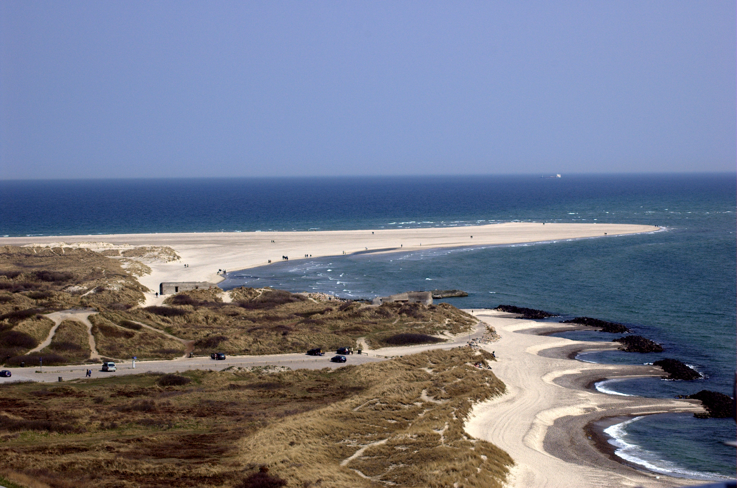
Grenen is a long sandbar spit at Skagen Odde (the headland of Jutland), north of the town of Skagen. Overview ''Grenen'' (The Branch) was named for its shape like a tree-branch, reaching out from the mainland. The beach of Grenen appears in many of the works of the Skagen Painters, a community that gathered there every summer between 1875 and the end of the 19th century. The area is also home to the Skagen Odde Nature Centre, designed by Jørn Utzon. Near the tip of the spit are two small museums: Skagen Bunker Museum and Grenens Kunstmuseum. Danish national road 40 terminates at Grenen, and it is one of the most popular tourist destinations in the country, with approximately 2 million visitors each year. Nature Grenen marks the junction between the strait of Skagerrak (part of the North Sea) and the Kattegat sea. The turbulent colliding waves have created a 4-km long curved sandbar above and below the waves stretching east. The reef is still active and has grown about 1 ... [...More Info...] [...Related Items...] OR: [Wikipedia] [Google] [Baidu] |
Greenland
Greenland is an autonomous territory in the Danish Realm, Kingdom of Denmark. It is by far the largest geographically of three constituent parts of the kingdom; the other two are metropolitan Denmark and the Faroe Islands. Citizens of Greenland are full Danish nationality law, citizens of Denmark and European Union citizenship, of the European Union. Greenland is one of the Special territories of members of the European Economic Area#Overseas countries and territories, Overseas Countries and Territories of the European Union and is part of the Council of Europe. It is the List of islands by area, world's largest island, and lies between the Arctic Ocean, Arctic and Atlantic oceans, east of the Arctic Archipelago, Canadian Arctic Archipelago. It is the location of the northernmost point of land in the world; Kaffeklubben Island off the northern coast is the world's Northernmost point of land, northernmost undisputed point of land—Cape Morris Jesup on the mainland was thought to ... [...More Info...] [...Related Items...] OR: [Wikipedia] [Google] [Baidu] |
Læsø
Læsø ("Isle of Ægir, Hlér") is the largest island in the North Sea bay of Kattegat, and is located off the northeast coast of the Jutland Peninsula, the Denmark, Danish mainland. Læsø is also the name of the municipality (Danish language, Danish, ''Municipalities of Denmark, kommune'') on that island. The island is a location mentioned in several instances in Old Norse sources detailing Norse mythology. In a 2010 survey, readers of the Danish newspaper ''Kristeligt Dagblad'' voted Læsø as Denmark's second most wonderful island, behind only Fur (island). Name and Norse mythology The modern Danish language, Danish form of the island's name, ''læsø'', developed from Old Norse ''Hlésey'', meaning 'Hlér's island'.McKinnell (2005:110) and Faulkes (1995:59). Hlér (Old Norse 'sea'), also known as ''Ægir'' (also Old Norse 'sea'), is a jötunn and personification of the sea in Norse mythology whose Nine Daughters of Ægir and Rán, nine daughters personify waves. Similarly, ... [...More Info...] [...Related Items...] OR: [Wikipedia] [Google] [Baidu] |
Mors (island)
Mors or Morsø (the latter more formal) is an island in the shallow sound called Limfjorden between Denmark's Jutland peninsula and the North Jutlandic Island. It has an area of 367.3 km2 and as of 1 January 2025, it had a population of 19,486."BEF4: Population 1. January by islands" (). Retrieved 28 June 2019. The main town on the island is called . Geologically Mors is unique. Like the neighbouring island of |
Himmerland
Himmerland is a peninsula in northeastern Jutland, Denmark. It is delimited to the north and the west by the Limfjord, to the east by the Kattegat, and to the south by the Mariager Fjord. The largest city is Aalborg; smaller towns include Hobro, Aars, Løgstør, Støvring and Nibe. In northeastern Himmerland is the Lille Vildmose, Denmark's largest raised bog, which sustains a rich bird life of international importance. Etymology It is generally assumed that the name Himmerland is derived from the tribe of the Cimbri since, in the ''Geography'' of Ptolemy (2nd century AD), the ''Kimbroi'' (in Greek ''Κίμβροι'') are located in the northernmost part of the peninsula of Jutland, called ''Kimbrikē chersonēsos'' in Greek (Κιμβρική Χερσόνησος). The Latin ''c'' and Greek ''k'' attest an earlier stage of Germanic in which the Germanic sound shift was not yet completed (*''k'' > *''χ'' > ''h''), or it has been assumed the Latin form may be derived through C ... [...More Info...] [...Related Items...] OR: [Wikipedia] [Google] [Baidu] |
Counties Of Denmark
The Counties of Denmark () were former subdivisions of metropolitan Denmark and overseas territories, used primarily for administrative regions, with each county having its own council with substantial powers. Originally there had been twenty-four counties, but the number was reduced to roughly fourteen in 1970 – the number fluctuated slightly over the next three decades. In 2006 there were thirteen traditional counties as well as three municipalities with county status (the island of Bornholm, which was a county from 1660 until 2002, became a ''regional municipality'' with county powers, but only briefly from 2003 until 2006). On 1 January 2007, as a result of the '' strukturreformen'', the counties were abolished and replaced by five larger '' regions'' which, unlike the counties, are not municipalities. Copenhagen County comprised all the municipalities of Metropolitan Copenhagen, except Copenhagen Municipality and Frederiksberg Municipality which, on account of the ... [...More Info...] [...Related Items...] OR: [Wikipedia] [Google] [Baidu] |
Isthmus
An isthmus (; : isthmuses or isthmi) is a narrow piece of land connecting two larger areas across an expanse of water by which they are otherwise separated. A tombolo is an isthmus that consists of a spit or bar, and a strait is the sea counterpart of an isthmus, a narrow stretch of sea between two landmasses that connects two larger bodies of water. Isthmus vs land bridge vs peninsula ''Isthmus'' and ''land bridge'' are related terms, with isthmus having a broader meaning. A land bridge is an isthmus connecting Earth's major land masses. The term ''land bridge'' is usually used in biogeology to describe land connections that used to exist between continents at various times and were important for the migration of people and various species of animals and plants, e.g. Beringia and Doggerland. An isthmus is a land connection between two bigger landmasses, while a peninsula is rather a land protrusion that is connected to a bigger landmass on one side only and surrounded by ... [...More Info...] [...Related Items...] OR: [Wikipedia] [Google] [Baidu] |
Vendsyssel 2 Lng N Ubt
Vendsyssel () is the northernmost traditional district of Denmark and of Jutland. Being divided from mainland Jutland by the Limfjord, it is technically a part of the North Jutlandic Island which also comprises the areas Hanherred and Thy. Vendsyssel is part of the North Denmark Region. Vendsyssel neighbours Hanherred to the southwest and Himmerland to the south, across the Limfjord. Whether the island Læsø is also a part of Vendsyssel, is a matter of definition. The major towns of Vendsyssel are Hjørring, Frederikshavn, Brønderslev, Sæby, Hirtshals, Løkken, Nørresundby and, on its northern tip, Skagen. The dominating city is, however, Aalborg which is mainly situated outside Vendsyssel on the southern shore of the Limfjord with Nørresundby as a secondary, northern centre. Etymology Adam of Bremen (ca. 1075) calls Vendsyssel Wendila, Ælnoth (ca. 1100) calls it Wendel, the Icelandic literature Vendill or Vandill. Derived from this is the ethnic name wændlar, Danish ven ... [...More Info...] [...Related Items...] OR: [Wikipedia] [Google] [Baidu] |
Syssel
A syssel is a historical type of country subdivision in Denmark and elsewhere in Scandinavia. The mediaeval Danish ''sysler'' may be compared to the '' fylker'' of Norway, the '' landskap'' of Sweden and Finland, the shires of England and Scotland, and the '' Gaue'' of the Holy Roman Empire. A ''syssel'' was subdivided into a number of hundreds or ''herreder''. The name still can be found in the Danish district of Vendsyssel, as well as in a governmental title, ''sýslumenn'', in Iceland, the Faroe Islands, and Svalbard. Jutland ''Sysler'' and hundreds: # Vendsyssel: Horns Herred, Vennebjerg Herred, Børglum Herred, Jerslev Herred, Hvetbo Herred, Kær Herred # Thysyssel: Hillerslev Herred, Hundborg Herred, Hassing Herred, Refs Herred # Sallingsyssel: Morsø Nørre Herred, Morsø Sønder Herred, Salling Nørre Herred, Harre Herred, Rødding Herred, Hindborg Herred and Fjends Herred) # Himmersyssel: Slet Herred, Hornum Herred, Fleskum Herred, Års Herred, Hellum Herred, Gi ... [...More Info...] [...Related Items...] OR: [Wikipedia] [Google] [Baidu] |
Thyborøn Channel
Thyborøn is a fishing village in Jutland, Denmark, with a population of 1,816 (1 January 2024),BY3: Population 1. January by rural and urban areas, area and population density The Mobile Statbank from mainly known for being the site of numerous shipwrecks, such as that of the Imperial n '' |
Salmonsens Konversationsleksikon
''Salmonsens Konversationsleksikon'' is a Danish encyclopedia An encyclopedia is a reference work or compendium providing summaries of knowledge, either general or special, in a particular field or discipline. Encyclopedias are divided into article (publishing), articles or entries that are arranged Alp ... that has been published in several editions. The first edition, ''Salmonsens Store Illustrerede Konversationsleksikon'' was published in nineteen volumes 1893–1911 by Brødrene Salmonsens Forlag, and named after the publisher Isaac Salmonsen. The second edition, ''Salmonsens Konversationsleksikon'', was published in 26 volumes 1915–1930, under the editorship of Christian Blangstrup (volume 1–21), and Johannes Brøndum-Nielsen and Palle Raunkjær (volume 22–26), issued by J. H. Schultz Forlagsboghandel. Editions * ''Salmonsens Store Illustrerede Konversationsleksikon'', 19 volumes, Copenhagen: Brødrene Salmonsen, 1893–1911 * ''Salmonsens Konversati ... [...More Info...] [...Related Items...] OR: [Wikipedia] [Google] [Baidu] |
Agger Tange
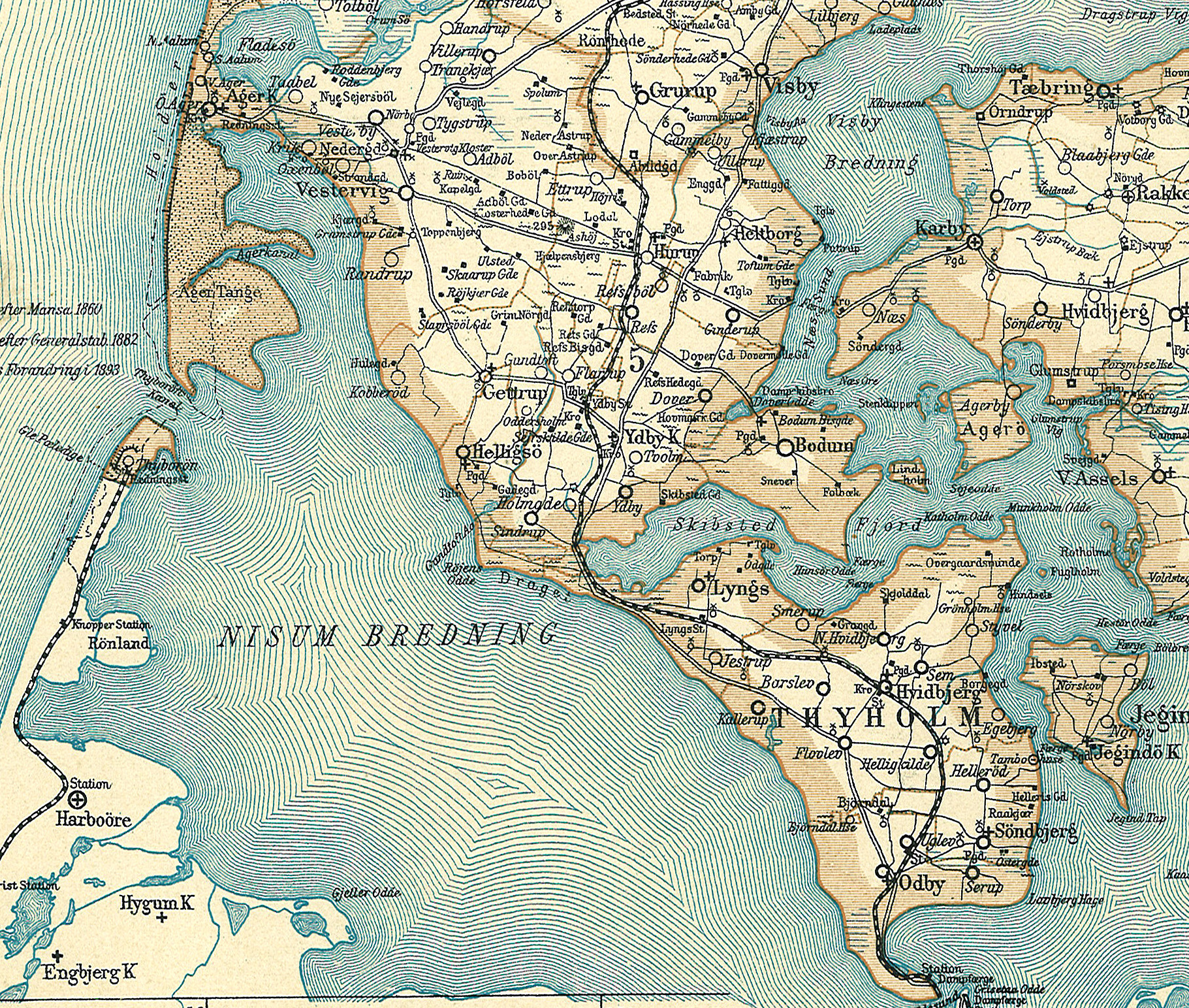
Agger Tange ("tange" is Danish language, Danish for "isthmus" or "panhandle") is a peninsula located between the Limfjord and the North Sea. Agger Tange protrudes from the North Jutlandic Island, immediately south of the village Agger (place), Agger in Thy (district), Thy. As the name implies, Agger Tange was originally an isthmus, but North Sea storms breached the tombolo in the 1800s, creating two peninsulas, north and south. The north peninsula retained the name Agger Tange, although it was no longer an isthmus. The south peninsula became known as Harboøre Tange. The two peninsulas are separated by the Thyborøn Channel, facilitating ship traffic through the Limfjord canal. History The sand tombolo of Agger Tange was created around 1100 AD, as a result of natural siltation. The North Sea coast is often windy and fierce, and Agger Tange has experienced many smaller floods during storms. In 1825, a severe storm breached and created what became known as the Agger Channel (in ... [...More Info...] [...Related Items...] OR: [Wikipedia] [Google] [Baidu] |


