|
North Holland
North Holland (, ) is a Provinces of the Netherlands, province of the Netherlands in the northwestern part of the country. It is located on the North Sea, north of South Holland and Utrecht (province), Utrecht, and west of Friesland and Flevoland. As of January 2023, it had a population of about 2,952,000 and a total area of , of which is water. From the 9th to the 16th century, the area was an integral part of the County of Holland. During this period West Friesland (region), West Friesland was incorporated. In the 17th and 18th centuries, the area was part of the province of Holland and commonly known as the Noorderkwartier (English: "Northern Quarter"). In 1840, the province of Holland was split into the two provinces of North Holland and South Holland. In 1855, the Haarlemmermeer was drained and turned into land. The provincial capital is Haarlem (pop. 161,265). The province's largest city and also the largest city in the Netherlands is the Dutch capital Amsterdam, with a ... [...More Info...] [...Related Items...] OR: [Wikipedia] [Google] [Baidu] |
Provinces Of The Netherlands
There are twelve provinces ( or ; Grammatical number#Overview, sing. ) of the Netherlands representing the administrative layer between the cabinet of the Netherlands, national government and the municipalities of the Netherlands, local governments, with responsibility for matters of subnational or regional importance. The most populous province is South Holland, with just over 3.8 million inhabitants , and also the most densely populated province with . With 391,124 inhabitants, Zeeland has the smallest population. However Drenthe is the least densely populated province with . In terms of area, Friesland is the largest province with a total area of . If water is excluded, Gelderland is the largest province by land area at . The province of Utrecht (province), Utrecht is the smallest with a total area of , while Flevoland is the smallest by land area at . In total about 10,000 people were employed by the provincial administrations in 2018. The provinces of the Netherlan ... [...More Info...] [...Related Items...] OR: [Wikipedia] [Google] [Baidu] |
Utrecht (province)
Utrecht (), officially the Province of Utrecht (), is a Provinces of the Netherlands, province of the Netherlands. It is located in the centre of the country, bordering the Eemmeer in the north-east, the province of Gelderland in the east and south-east, the province of South Holland in the west and south-west and the province of North Holland in the north-west and north. The province of Utrecht has a population of about 1,388,000 as of January 2023. With a land area of approximately , it is the second smallest province in the country. Apart from its Utrecht, eponymous capital, major cities and towns in the province are Amersfoort, Houten, IJsselstein, Nieuwegein, Veenendaal and Zeist. The busiest railway station in the Netherlands, Utrecht Centraal railway station, Utrecht Centraal, is located in the province of Utrecht. History The Archdiocese of Utrecht (695–1580), Bishopric of Utrecht was established in 695 when Saint Willibrord was consecrated bishop of the Frisians a ... [...More Info...] [...Related Items...] OR: [Wikipedia] [Google] [Baidu] |
Binnenstad Hoorn, 1621 Hoorn, Netherlands - Panoramio (71)
{{geodis ...
Binnenstad (Dutch, 'Inner city') may refer to the following places in the Netherlands: * Binnenstad (Amsterdam) * Binnenstad (Maastricht) * Binnenstad (tram stop) in Utrecht See also * Inner city * City centre A city centre, also known as an urban core, is the Commerce, commercial, Culture, cultural and often the historical, Politics, political, and geographic heart of a city. The term "city centre" is primarily used in British English, and closely e ... [...More Info...] [...Related Items...] OR: [Wikipedia] [Google] [Baidu] |
Amsterdam, Netherlands (Unsplash 2Hs8zbwOLDA)
Amsterdam ( , ; ; ) is the capital and largest city of the Kingdom of the Netherlands. It has a population of 933,680 in June 2024 within the city proper, 1,457,018 in the urban area and 2,480,394 in the metropolitan area. Located in the Dutch province of North Holland, Amsterdam is colloquially referred to as the "Venice of the North", for its large number of canals, now a UNESCO World Heritage Site. Amsterdam was founded at the mouth of the Amstel River, which was dammed to control flooding. Originally a small fishing village in the 12th century, Amsterdam became a major world port during the Dutch Golden Age of the 17th century, when the Netherlands was an economic powerhouse. Amsterdam was the leading centre for finance and trade, as well as a hub of secular art production. In the 19th and 20th centuries, the city expanded and new neighborhoods and suburbs were built. The city has a long tradition of openness, liberalism, and tolerance. Cycling is key to the city's moder ... [...More Info...] [...Related Items...] OR: [Wikipedia] [Google] [Baidu] |
Amsterdam Airport Schiphol
Amsterdam Airport Schiphol , known informally as Schiphol Airport (, ), is the main international airport of the Netherlands, and is one of the major hubs for the SkyTeam airline alliance. It is located southwest of Amsterdam, in the municipality of Haarlemmermeer in the province of North Holland. It was the world's third busiest airport by international passenger traffic in 2023. With almost 72 million passengers in 2019, it is the third-busiest airport in Europe in terms of passenger volume and the busiest in Europe in terms of aircraft movements. With an annual cargo tonnage of 1.74 million, it is the 4th busiest in Europe. AMS covers a total area of of land. The airport is built on the single-terminal concept: one large terminal split into three departure halls. Schiphol is the principal hub for KLM and its regional affiliate KLM Cityhopper as well as for Martinair. The airport also serves as an operating base for Corendon Dutch Airlines, easyJet, Transavia, TUI f ... [...More Info...] [...Related Items...] OR: [Wikipedia] [Google] [Baidu] |
Water Board (Netherlands)
In the Netherlands, a water board, water council or water authority () is a regional governing body solely charged with the management of surface water in the environment. Water boards are independent of administrative governing bodies like provinces and municipalities. In general, they are responsible for managing rivers and canals, issues with the flow of watercourses and drainage issues, water collection, flood and erosion prevention and provision of potable water. They manage polder systems, water levels, water barriers and Lock (water navigation), locks, enforcements, water quality and sewage treatment in their respective regions. The concept of a coordinating "High Water Authority" (''Hoogheemraadschap'') originated in what now is the province of South Holland in the 12th century. Background Since the settlement of the Netherlands, large parts of the land have been constantly threatened by rivers and the sea. Fertile soil and peatlands often were located near rivers, thu ... [...More Info...] [...Related Items...] OR: [Wikipedia] [Google] [Baidu] |
List Of Municipalities Of The Netherlands
Since 1 January 2023, there have been 342 regular municipalities ( ; Grammatical number#Overview, sing. ) and three Caribbean Netherlands, special municipalities ( ) in the Netherlands. The latter is the status of three of the six island territories that make up the Dutch Caribbean. Municipalities are the second-level administrative division, or public body (Netherlands), public bodies (), in the Netherlands and are subdivisions of their respective provinces of the Netherlands, provinces. Their duties are delegated to them by the Cabinet of the Netherlands, central government and they are ruled by a municipal council (Netherlands), municipal council that is elected every four years. Municipal merger (politics), mergers have reduced the total number of municipalities by two-thirds since the first official boundaries were created in the mid 19th century. Municipalities themselves are informally subdivided into districts and neighbourhoods for administrative and statistical ... [...More Info...] [...Related Items...] OR: [Wikipedia] [Google] [Baidu] |
Haarlemmermeer
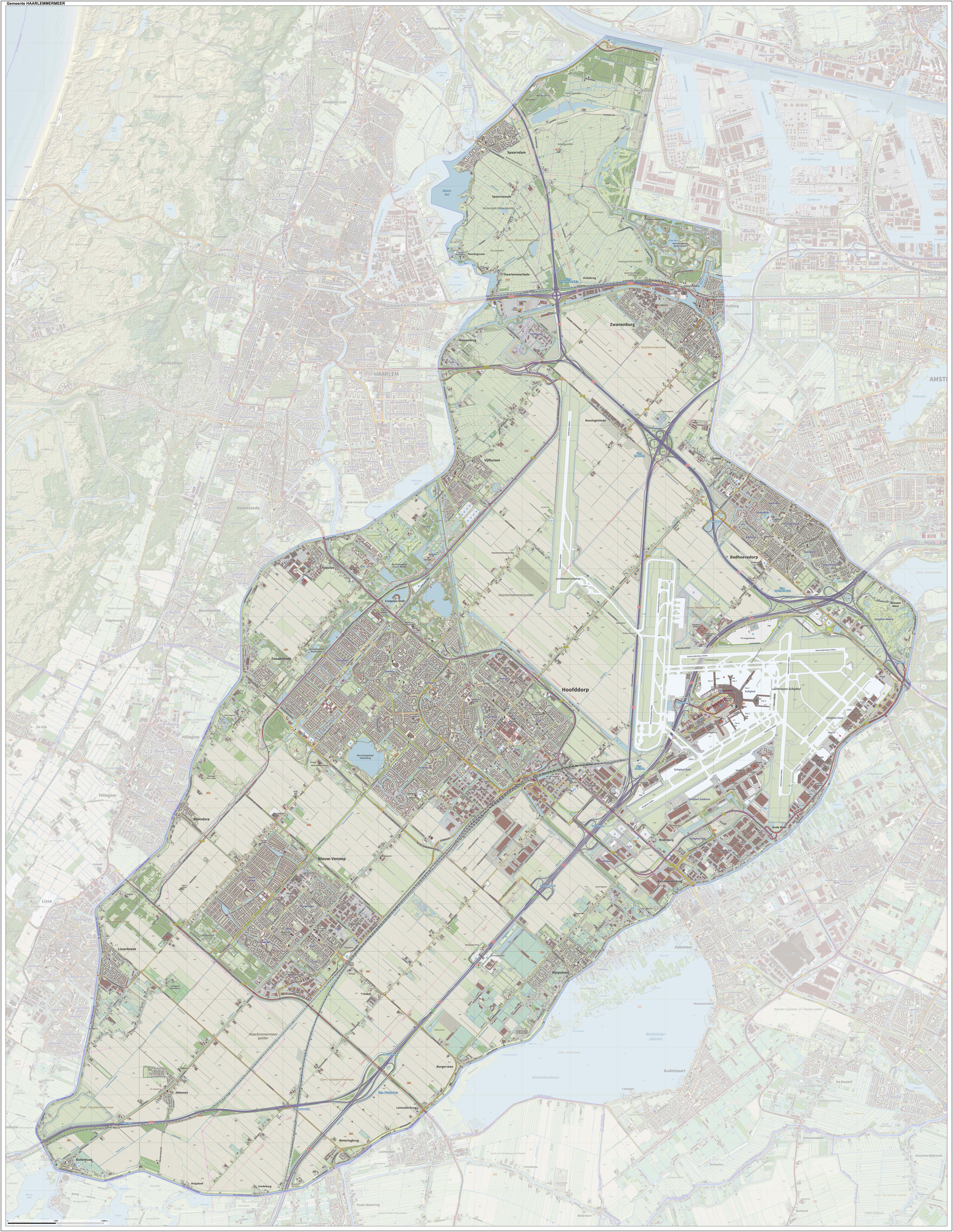
Haarlemmermeer () is a List of municipalities of the Netherlands, municipality in the west of the Netherlands, in the Provinces of the Netherlands, province of North Holland. Haarlemmermeer is a polder, consisting of land reclaimed from water. The name Haarlemmermeer means 'Haarlem's lake', referring to the body of water from which the region was reclaimed in the 19th century. Haarlemmermeer's main town is Hoofddorp, which has a population of 76,660. Hoofddorp, along with the rapidly growing towns of Nieuw-Vennep and Badhoevedorp, are part of the Randstad agglomeration. The main international airport of the Netherlands, Amsterdam Airport Schiphol, Schiphol, is located in Haarlemmermeer. History The original Haarlemmermeer lake is said to have been mostly a peat bog, a relic of a northern arm of the Rhine which passed through the district in Ancient Rome, Roman times. In 1531, the original Haarlemmermeer had an area of , and near it were three smaller lakes: the Leidsche Meer (Leid ... [...More Info...] [...Related Items...] OR: [Wikipedia] [Google] [Baidu] |
Noorderkwartier
Noorderkwartier (; ) is a historical term referring to the part of the former Dutch province of Holland north of the river IJ, covering the regions Kennemerland, Zaanstreek, Waterland and West Friesland and now part of the modern province of North Holland North Holland (, ) is a Provinces of the Netherlands, province of the Netherlands in the northwestern part of the country. It is located on the North Sea, north of South Holland and Utrecht (province), Utrecht, and west of Friesland and Flevola .... Other historical terms for this area were "North Holland", "Noordeland", and "Noorderland". {{Coord missing, Netherlands Regions of the Netherlands Regions of North Holland ... [...More Info...] [...Related Items...] OR: [Wikipedia] [Google] [Baidu] |
West Friesland (region)
West Friesland () is a contemporary region in the Northwest of the Netherlands, in the province of North Holland. History The River Vlie (also called Fli), is an extension of the IJssel branch of the Rhine River. The river divides the northern Netherlands into two parts, the western and the eastern part. In the eleventh century, heavy rainfall caused the river to flood over large parts of the land. The Zuiderzee bay (previously a lake called Lacus Flevo by Roman authors) was formed, separating West Friesland from the contemporary Province of Friesland. In the Middle Ages, the Westflinge area of West Friesland became an island, bordered on the north by the Medem and Zijpe inlets, and to the south by various interconnecting lakes (now polder land) that were connected with the Zuiderzee. Because of this, the toponym "West Friesland" was applied more to the Westflinge area than to the original West Friesland. For approximately 300 years, West Friesland operated as an autonomo ... [...More Info...] [...Related Items...] OR: [Wikipedia] [Google] [Baidu] |


