|
Norderneyer Seegatt
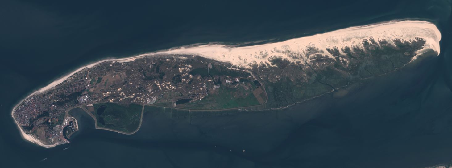
The Norderneyer Seegatt or (officially) Norderneyer Seegat is a gat in the southern North Sea. The gat runs in a north–south direction between the East Frisian Islands of Juist to the west and Norderney to the east. There are two marked shipping channels for craft navigating from the North Sea into the Norderneyer Seegatt. From the west the gat is approached along the Schluchter and from the east the Dovetief. The Norderneyer Seegatt is subject to marked morphological changes as a result of tidal action, so that the location and depth of the channels changes continuously. External links Information about the ''Norderneyer Seegat'' at www.wattenschipper.de''Norderney'' at www.skipperguide.de Wadden Sea Juist Norderney {{EastFrisia-stub ... [...More Info...] [...Related Items...] OR: [Wikipedia] [Google] [Baidu] |
Gat (landform)
A gat (, ''gat''; , ''Seegat'' or diminutive ''Gatje'') is an inshore channel or strait connecting coastal waters with the open sea or dividing two landmasses, such as two islands or an island and a peninsula. Algemeen Nederlands Woordenboek,Zeegat (in Dutch). Accessed on July 5, 2024. Gats are usually relatively narrow but deep and are in many instances constantly eroded by currents flowing back and forth, such as tidal currents. The term is mostly used for features on the North Sea and Baltic Sea coasts. According to Whittow a gat is either a strait dividing offshore islands from the mainland e.g. the Frisian Islands, or it is an opening in a line of sea cliffs allowing access to the coast from inland.Whittow, John (1984). ''Dictionary of Physical Geography''. London: Penguin, 1984, pp. 214 and 240. . The term sometimes also refers to a shallower passage on lagoon coasts, including those without any tidal range, and can also refer to shallow bars in an area of mudflats. It ... [...More Info...] [...Related Items...] OR: [Wikipedia] [Google] [Baidu] |
North Sea
The North Sea lies between Great Britain, Denmark, Norway, Germany, the Netherlands, Belgium, and France. A sea on the European continental shelf, it connects to the Atlantic Ocean through the English Channel in the south and the Norwegian Sea in the north. It is more than long and wide, covering . It hosts key north European shipping lanes and is a major fishery. The coast is a popular destination for recreation and tourism in bordering countries, and a rich source of energy resources, including wind energy, wind and wave power. The North Sea has featured prominently in geopolitical and military affairs, particularly in Northern Europe, from the Middle Ages to the modern era. It was also important globally through the power northern Europeans projected worldwide during much of the Middle Ages and into the modern era. The North Sea was the centre of the Viking Age, Vikings' rise. The Hanseatic League, the Dutch Golden Age, Dutch Republic, and Kingdom of Great Britain, Brita ... [...More Info...] [...Related Items...] OR: [Wikipedia] [Google] [Baidu] |
East Frisian Islands
The East Frisian Islands (, ; ; ) are a chain of islands in the North Sea, off the coast of East Frisia in Lower Saxony, Germany. The islands extend for some from west to east between the mouths of the Ems and Jade / Weser rivers and lie about offshore. Between the islands and the mainland are extensive mudflats, known locally as ''Watten'', which form part of the Wadden Sea. In front of the islands are Germany's territorial waters, which occupy a much larger area than the islands themselves. The islands, the surrounding mudflats and the territorial waters (The ''Küstenmeer vor den ostfriesischen Inseln'' nature reserve) form a close ecological relationship. The island group makes up about 5% of the Lower Saxon Wadden Sea National Park. The largest island by surface area is Borkum, located at the western end of the chain; the other six inhabited islands are from west to east: Juist, Norderney with the largest town in the islands, Baltrum, Langeoog, Spiekeroog and Wange ... [...More Info...] [...Related Items...] OR: [Wikipedia] [Google] [Baidu] |
Juist
Juist (; ) is an island and municipality in the district of Aurich (district), Aurich in Lower Saxony in Germany. The island is one of seven East Frisian Islands at the edge of the Lower Saxony, Lower Saxon Wadden Sea in the southern North Sea. It is located between Borkum Island (west), Memmert Island (southwest) and Norderney (east). The island is long and from to wide, depending on the tide levels. There are two villages on the island: the main village Juist, and Loog. The island is separated from Norderney by the Norderneyer Seegatt. Overview and geography The tallest buildings on Juist that can be seen from the North Sea are the water tower and an old hotel. There is a lighthouse on the island, but it is not in use. At the western end of the island is the Billreef, a large sandbank where birds such as dunlins, grey plovers and red knot, knots rest during their migration. In the western part of the island, the beach and the dunes are eroded by the sea. The edge of the dunes ... [...More Info...] [...Related Items...] OR: [Wikipedia] [Google] [Baidu] |
Norderney
Norderney (; ) is one of the seven populated East Frisian Islands off the North Sea coast of Germany. The island is , having a total area of about and is therefore Germany's ninth-largest island. Norderney's population amounts to about 5,850 people. In 1946 Norderney gained municipal status and belongs to the Aurich "Kreis" (county). On the northern side of the island lies a long sandy beach. The neighbouring island to the east is Baltrum, which lies about 800m (half a mile) away beyond the Wichter Ee. To the west is the island of Juist, about away on the other side of the Norderneyer Seegatt. The entire eastern half of Norderney belongs to the Lower Saxon Wadden Sea National Park. Access to the park is restricted, as it is subdivided in zones of different accessibility for the protection of the wildlife. The status as a National Park also affects all types of traffic on the island, while especially car traffic is subject to strict regulations. The mainland is easily ... [...More Info...] [...Related Items...] OR: [Wikipedia] [Google] [Baidu] |
Sea Mark
A sea mark, also seamark and navigation mark, is a form of aid to navigation and pilotage that identifies the approximate position of a maritime channel, hazard, or administrative area to allow boats, ships, and seaplanes to navigate safely. There are three types of sea mark: beacons fixed to the seabed or on shore, towers (sometimes rock cairns) built on the shore or on a submerged rock/object (especially in calmer waters), and buoys (consisting of a floating object that is usually anchored to a specific location on the bottom of the sea or to a submerged object). Sea marks are used to indicate channels, dangerous rocks or shoals, mooring positions, areas of speed limits, traffic separation schemes, submerged shipwrecks, and for a variety of other navigational purposes. Some are only intended to be visible in daylight ('' daymarks''), others have some combination of lights, reflectors, fog bells, foghorns, whistles and radar reflectors to make them usable at night and i ... [...More Info...] [...Related Items...] OR: [Wikipedia] [Google] [Baidu] |
Sea Lane
A sea lane, sea road or shipping lane is a regularly used navigable route for large water vessels (ships) on wide waterways such as oceans and large lakes, and is preferably safe, direct and economic. During the Age of Sail, they were determined by the distribution of land masses but also by the prevailing winds, whose discovery was crucial for the success of long maritime voyages. Sea lanes are very important for seaborne trade. History The establishment of the North Atlantic sea lanes was inspired by the sinking of the US mail steamer SS ''Arctic'' by collision with the French steamer SS ''Vesta'' in October 1854 which resulted in the loss of over 300 lives. Lieutenant M. F. Maury of the US Navy first published a section titled "Steam Lanes Across the Atlantic" in his 1855 ''Sailing Directions'' proposing sea lanes along the 42 degree latitude. A number of international conferences and committees were held in 1866, 1872, 1887, 1889, and 1891 all of which left the de ... [...More Info...] [...Related Items...] OR: [Wikipedia] [Google] [Baidu] |
Tide
Tides are the rise and fall of sea levels caused by the combined effects of the gravitational forces exerted by the Moon (and to a much lesser extent, the Sun) and are also caused by the Earth and Moon orbiting one another. Tide tables can be used for any given locale to find the predicted times and amplitude (or " tidal range"). The predictions are influenced by many factors including the alignment of the Sun and Moon, the phase and amplitude of the tide (pattern of tides in the deep ocean), the amphidromic systems of the oceans, and the shape of the coastline and near-shore bathymetry (see '' Timing''). They are however only predictions, the actual time and height of the tide is affected by wind and atmospheric pressure. Many shorelines experience semi-diurnal tides—two nearly equal high and low tides each day. Other locations have a diurnal tide—one high and low tide each day. A "mixed tide"—two uneven magnitude tides a day—is a third regular category. ... [...More Info...] [...Related Items...] OR: [Wikipedia] [Google] [Baidu] |
List Of Geographical Names Of The German Bight
A list is a set of discrete items of information collected and set forth in some format for utility, entertainment, or other purposes. A list may be memorialized in any number of ways, including existing only in the mind of the list-maker, but lists are frequently written down on paper, or maintained electronically. Lists are "most frequently a tool", and "one does not ''read'' but only ''uses'' a list: one looks up the relevant information in it, but usually does not need to deal with it as a whole".Lucie Doležalová,The Potential and Limitations of Studying Lists, in Lucie Doležalová, ed., ''The Charm of a List: From the Sumerians to Computerised Data Processing'' (2009). Purpose It has been observed that, with a few exceptions, "the scholarship on lists remains fragmented". David Wallechinsky, a co-author of ''The Book of Lists'', described the attraction of lists as being "because we live in an era of overstimulation, especially in terms of information, and lists help us ... [...More Info...] [...Related Items...] OR: [Wikipedia] [Google] [Baidu] |
Wadden Sea
The Wadden Sea ( ; ; or ; ; ; ) is an intertidal zone in the southeastern part of the North Sea. It lies between the coast of northwestern continental Europe and the range of low-lying Frisian Islands, forming a shallow body of water with tidal flats and wetlands. It has a high biodiversity, biological diversity and is an important area for both breeding and migrating birds. In 2009, the Dutch and German parts of the Wadden Sea were inscribed on UNESCO's World Heritage List and the Danish part was added in June 2014. The Wadden Sea stretches from Den Helder, in the northwest of the Netherlands, past the great river estuaries of Germany to its northern boundary at Skallingen in Denmark along a total coastline of some and a total area of about . Within the Netherlands, it is bounded from the IJsselmeer by the Afsluitdijk. Historically, the coastal regions were often subjected to large floods, resulting in thousands of deaths, including the Saint Marcellus' floods of 1219 and 136 ... [...More Info...] [...Related Items...] OR: [Wikipedia] [Google] [Baidu] |


