|
Niger River
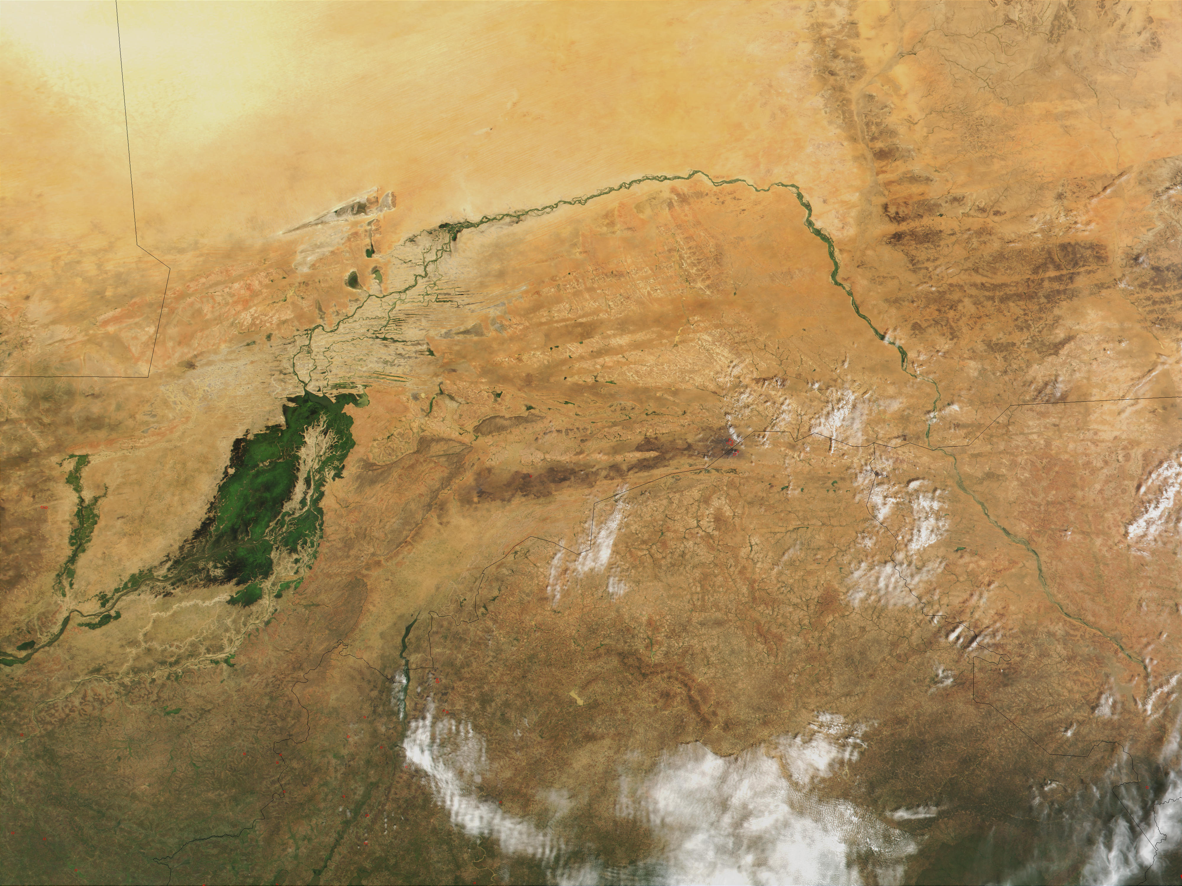
The Niger River ( ; ) is the main river of West Africa, extending about . Its drainage basin is in area. Its source is in the Guinea Highlands in south-eastern Guinea near the Sierra Leone border. It runs in a crescent shape through Mali, Niger, on the border with Benin and then through Nigeria, discharging through a massive River delta, delta, known as the Niger Delta, into the Gulf of Guinea in the Atlantic Ocean. The Niger is the third-longest river in Africa, exceeded by the Nile and the Congo River. Its main tributary is the Benue River. Etymology The Niger has different names in the different languages of the region: * Fula language, Fula: ''Maayo Jaaliba'' * Manding languages, Manding: ''Jeliba'' or ''Joliba'' "great river" * Tuareg languages, Tuareg: ''Eġərəw n-Igərǝwăn'' "river of rivers" * Songhay languages, Songhay: ''Isa'' "the river" * Zarma language, Zarma: ''Isa Beeri'' "great river" * Hausa language, Hausa: ''Kwara'' *Nupe language, Nupe: ''Èdù'' ... [...More Info...] [...Related Items...] OR: [Wikipedia] [Google] [Baidu] |
Bani River
The Bani River is the principal tributary of the Niger River in Mali. The river is formed from the confluence of the Baoulé and Bagoé rivers some east of Bamako and it merges with the Niger near Mopti. Its length is about . Geography The Bani River has three main tributaries: the Baoulé that rises near Odienné in Côte d'Ivoire and passes just south of Bougouni, the Bagoé River that rises near Boundiali in Côte d'Ivoire and the Banifing-Lotio that drains the region around Sikasso. The drainage basin upstream of Douna has an area of , 85% of which lies in southern Mali and 15% in northern Côte d'Ivoire. The annual rainfall varies across the catchment basin with the southern area in Côte d'Ivoire receiving a year while the northern area around Douna receiving only . For the period 1965-1995 the average annual rainfall for the basin was . The rainfall is seasonal with most of the rain falling between May and October. The maximum rainfall occurs in August. The disc ... [...More Info...] [...Related Items...] OR: [Wikipedia] [Google] [Baidu] |
Niger Delta
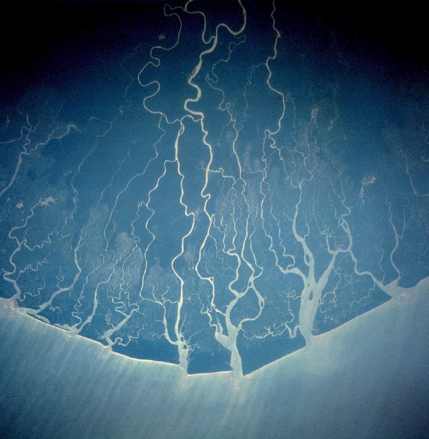
The Niger Delta is the delta of the Niger River sitting directly on the Gulf of Guinea on the Atlantic Ocean in Nigeria. It is located within nine coastal southern Nigerian states, which include: all six states from the South South geopolitical zone, one state ( Ondo) from South West geopolitical zone and two states ( Abia and Imo) from South East geopolitical zone. The Niger Delta is a very densely populated region sometimes called the Oil Rivers because it was once a major producer of palm oil. The area was the British Oil Rivers Protectorate from 1885 until 1893, when it was expanded and became the Niger Coast Protectorate. The delta is a petroleum-rich region and has been the center of international concern over extensive pollution which is often used as an example of ecocide. The principal cause is major oil spills by multinational corporations of the petroleum industry. Geography The Niger Delta, as now defined officially by the Nigerian government, extends ove ... [...More Info...] [...Related Items...] OR: [Wikipedia] [Google] [Baidu] |
Maninka Language
Maninka (also known as Malinke), or more precisely Eastern Maninka, is the name of several closely related languages and dialects of the southeastern Manding subgroup of the Mande language family (itself, possibly linked to the Niger–Congo phylum). It is the mother tongue of the Malinké people in Guinea, where it is spoken by 3.1 million people and is the main language in the Upper Guinea region, and in Mali, where the closely related Bambara is a national language, as well as in Liberia, Senegal, Sierra Leone and Ivory Coast, where it has no official status. It was the language of court and government during the Mali Empire. Phonology The Wudala dialect of Eastern Maninka, spoken in the central highlands of Guinea and comprehensible to speakers of all dialects in that country, has the following phonemic inventory.Mamadou Camara (1999) ''Parlons Malinké'' (Apart from tone, which is not written, sounds are given in orthography, as IPA values are not certain.) Tones The ... [...More Info...] [...Related Items...] OR: [Wikipedia] [Google] [Baidu] |
Kaduna River
The Kaduna River is a tributary of the Niger River which flows for through Nigeria. It got its name from the crocodiles that lived in the river and surrounding area. Kaduna (city), Kaduna in the native dialect, Hausa language, Hausa, was the word for "crocodiles". It starts in Plateau State on the Jos Plateau southwest of Jos town, flows through its namesake Kaduna State and through its capital Kaduna (city), Kaduna, and meets the Niger River in Niger State. Most of its course passes through open savanna woodland, but its lower section has cut several gorges above its entrance into the extensive Niger floodplains. The river is used for fishing and transport of local produce. Pollution Urban and industrial wastes have been linked to elevated temperatures and heavy metal concentrations in the River Kaduna (Arah, 1985). Untreated industrial wastes that are carelessly dumped directly or indirectly into River Kaduna's inflow wastewaters have been determined to be a source of pollu ... [...More Info...] [...Related Items...] OR: [Wikipedia] [Google] [Baidu] |
Oli River
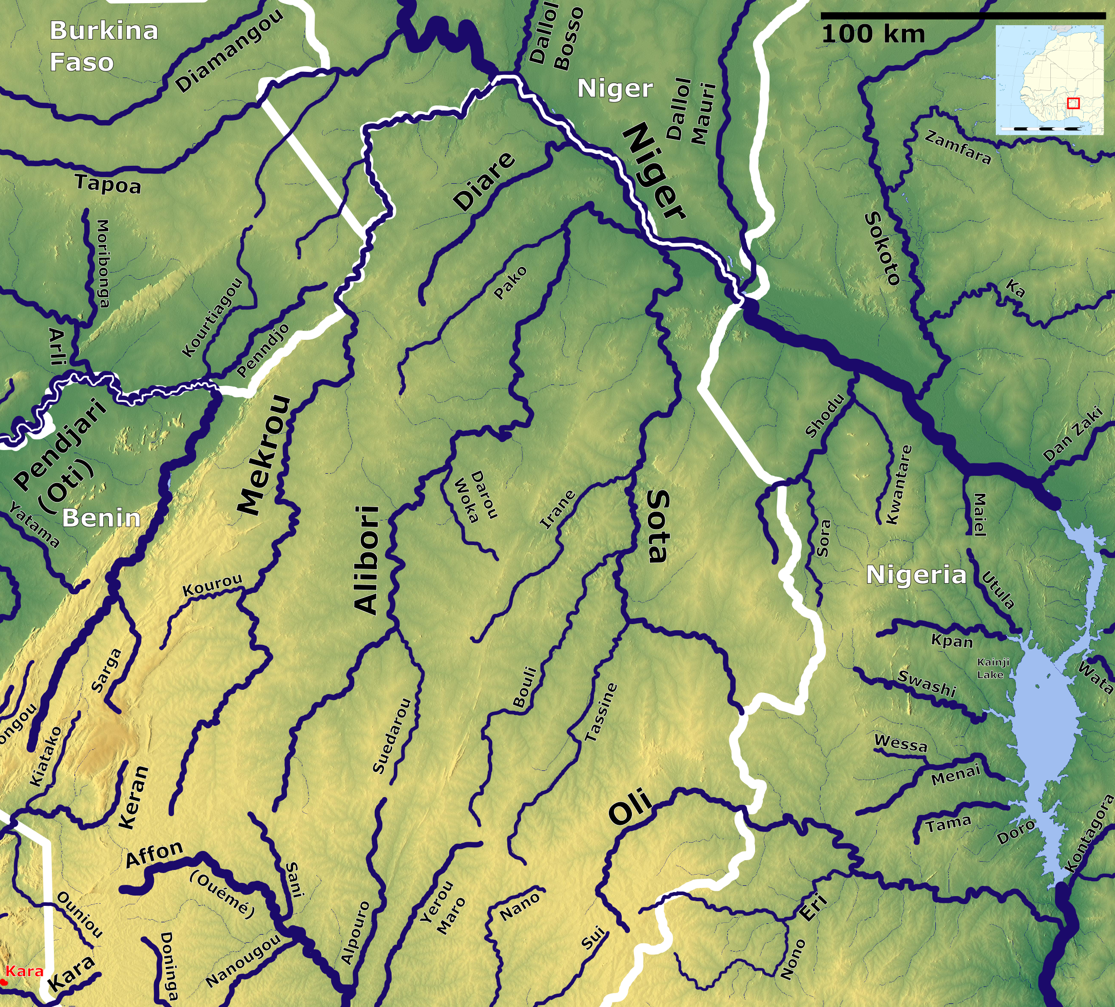
The Oli River is a river of Nigeria and Benin, tributary of the Niger River The Niger River ( ; ) is the main river of West Africa, extending about . Its drainage basin is in area. Its source is in the Guinea Highlands in south-eastern Guinea near the Sierra Leone border. It runs in a crescent shape through Mali, Nige ....Rand McNally, ''The New International Atlas'', 1993. References Rivers of Benin Niger River Rivers of Nigeria {{Benin-river-stub ... [...More Info...] [...Related Items...] OR: [Wikipedia] [Google] [Baidu] |
Sota River
The Sota is a river of northern Benin flowing through the departments of Borgou and Alibori. It is a tributary of the Niger River and the Tassiné River is one of its tributaries. The river is approximately in length and covers a basin area of . Geography The Sota rises northeast of the town of Ndali in the Borgou Department. The river runs toward the north-north-east and empties into the Niger River at Malanville. Rainfall The annual precipitation has been recorded at several stations in the basin of the Sota: * Segbana (center-east of the basin, near the Nigerian border): spread over 53 days. * Kandi (center-west of the basin): , spread over 80 days * Malanville (at the north end of the basin at the confluence with Niger): in 53 days There is everywhere a large surplus rainfall from July to September (boreal summer), giving rise to violent floods, but the deficit is a severe dry season from December to April. Hydrometry The flow of the river has been observed for 40 y ... [...More Info...] [...Related Items...] OR: [Wikipedia] [Google] [Baidu] |
Alibori River
The Alibori River is a river in the northeastern part of Benin. It rises near the village of Tobré in Atakora Department and flows northeast, ultimately emptying into the Niger River near Birni-Lafia.Rand McNally, ''The New International Atlas'', 1993. In Alibori Department it forms the eastern border of the communes of Banikoara and Karimama, as well the eastern boundary of W Transborder Park. The Pako River is one of its tributaries. It is populated with crocodile Crocodiles (family (biology), family Crocodylidae) or true crocodiles are large, semiaquatic reptiles that live throughout the tropics in Africa, Asia, the Americas and Australia. The term "crocodile" is sometimes used more loosely to include ...s. References Rivers of Benin Tributaries of the Niger River {{Benin-river-stub ... [...More Info...] [...Related Items...] OR: [Wikipedia] [Google] [Baidu] |
Mékrou River
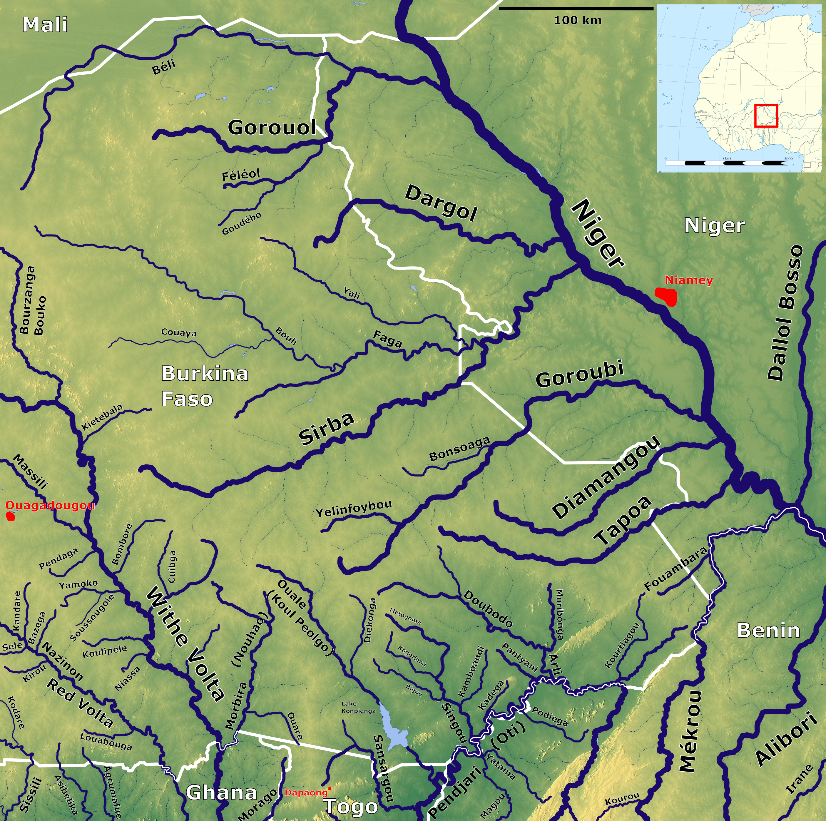
The Mékrou River is a river of Benin, Burkina Faso, and Niger. It flows through the W National Park. A tributary of the Niger River The Niger River ( ; ) is the main river of West Africa, extending about . Its drainage basin is in area. Its source is in the Guinea Highlands in south-eastern Guinea near the Sierra Leone border. It runs in a crescent shape through Mali, Nige ..., it begins in Benin north of Kouande and flows for 250 kilometers. It forms part of the border between Benin and Burkina Faso and between Benin and Niger. The proposed construction of the Dyondyonga electricity dam on the river has caused concern among environmentalistsUNESCO (2003), W-Arly-Pendjari Complex. Notes References * Rivers of Benin Rivers of Burkina Faso Rivers of Niger Tributaries of the Niger River International rivers of Africa Benin–Burkina Faso border Benin–Niger border {{Niger-river-stub ... [...More Info...] [...Related Items...] OR: [Wikipedia] [Google] [Baidu] |
Sirba River
 The Sirba River is a tributary of the Niger River in western Africa. The Sirba arises in Burkina Faso and flows east, crosses into Niger and then forms a short part of the international border between the two countries. It meets the Niger River at the midway point between the settlements of Gothèye and Karma, Niger, Karma in Niger, about 50 kilometres upstream from Niamey.
Rivers of Burkina Faso
Rivers of Niger
International rivers of Africa
Tributaries of the Niger River
Burkina Faso–Niger border
{{BurkinaFaso-river-stub ...
[...More Info...] [...Related Items...] OR: [Wikipedia] [Google] [Baidu] |
Béli River
The Béli River is a seasonal river of northern Burkina Faso, just south of the Malian border. It is a western tributary of the Niger River, the confluence is near Ayourou Ayourou (or Ayorou or Ayerou) is a town and rural commune in the Tillabéri Region, in western Niger. It is situated 208 km northwest of the capital Niamey near the Malian border. The old town stands on an eponymous island An island .... Rivers of Burkina Faso {{BurkinaFaso-river-stub ... [...More Info...] [...Related Items...] OR: [Wikipedia] [Google] [Baidu] |
Milo River
The Milo River is a river in Guinea in West Africa. It rises in the Simandou Mountains near Beyla, flows about to the south of Siguiri and flows north at which point it becomes one of the main tributaries of the River Niger. The pre-colonial Baté Empire was founded in the seventeenth century and was situated in the Milo River valley. In the colonial period, the river was a valuable transportation route, as it was navigable to shallow-draft vessels from Kankan Kankan ( Mandingo: Kánkàn; N’ko: ߞߊ߲ߞߊ߲߫) is the largest city in Guinea in land area, and the third largest in population, with a population of 198,013 people as of 2020. The city is located in eastern Guinea about east of the ... to the Niger River. References Rivers of Guinea Tributaries of the Niger River {{Guinea-river-stub ... [...More Info...] [...Related Items...] OR: [Wikipedia] [Google] [Baidu] |


